

The first step to learning a language is making a plan. Revisiting your study plan often and making adjustments as necessary will also help boost your effectiveness in learning Chinese. In this blog, we will present a ten step process for creating the perfect Chinese language study plan.
About the author: I am an American English native speaker has been studying Chinese for almost two decades. I also hold a Bachelor's degree in Chinese and I know what it takes to become fluent in Mandarin as a native English speaker. Let's get this list started! 
0 Comments
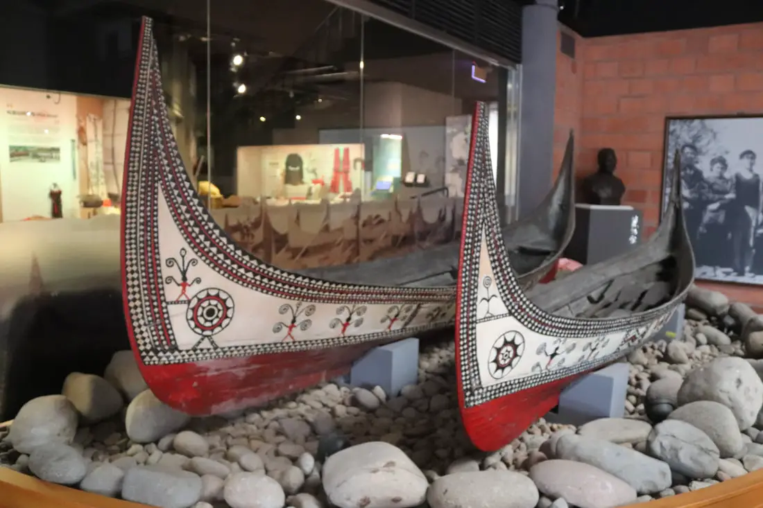
Academia Sinica's Museum of Ethnology features artifacts from Taiwan's indigenous people and also Han Chinese culture. Entrance is free, it is usually devoid of people, and has amazing ancient artifacts from Taiwan. It is definitely worth a visit on your trip to Taipei.
Background: The museum first began in 1988, and was formerly the Department of Ethnology Studies, Academia Sinica. The Ethnology Department was created in 1928 in Beijing. After 1949, the institute was moved to Taiwan as part of the ROC retreat to Taiwan. Much of the collection comes from Taiwan and China and includes thousands of pieces from prehistoric times from Indigenous people in Taiwan and Han Chinese peoples. Website: https://www.ioe.sinica.edu.tw/index.aspx?SiteID=530367205133077215 Hours: Wednesday and Saturday from 9:30 AM to 4:30 PM Price: Free! Tours: You can book a tour of Taipei on Tripadvisor here, KKday here or Klook here. Where to stay: High end: We have stayed at and recommend the Nangang Marriott (book on Booking.com here or Agoda here). We have also stayed at and recommend the Yuanshan Grand Hotel, once the tallest building in Taiwan and still the most grand (book on Booking.com here or Agoda here). Looking for a hotel? We recommend booking through Booking.com here, which provides the best quality selection of accommodation in Taiwan. Find out where to stay in our Taiwan hotels guide or search for the best hotel deals in Taiwan here. How to get there: By Car/Scooter: There is paid car parking at Academia Sinica, and scooters must park outside. Looking for scooter rental in Taipei? You can search on Klook here or KKday here to search for options. You can also check out our scooter rental guide here. If you are looking for car rentals, you can also search Qeeq here, Klook here, or KKday here. You can also check out our car rental guide here. By MRT/Bus: Take the blue MRT line to Nangang Exhibition Hall station, then transfer to any number of busses from exit 5 to Academia Sinica. You can also book an MRT travel pass on Klook here. By Bicycle: Cycling is the best way to enjoy Taiwan's landscapes if you have the time and energy. Looking for bicycle rentals in Taiwan? You can use Taiwan's many Youbike sharing stations, or search for rentals on KKday here, and search for tours on Klook here. You can also check out our Taiwan cycling guide here. You can also book a Sunset Riverside Bike Ride and Historical Tour, 4 Hour Cycling in Taipei, Ultimate 8-Hour Cycling City Tour, or Taipei City Bike Tour with Night Market Experience on TripAdvisor here. For more information, check out our Taiwan transportation guide here. Map: Please see below: 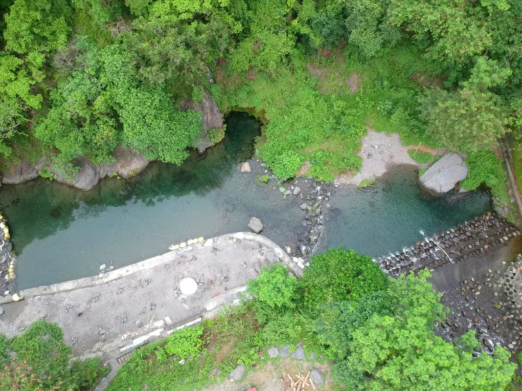
Haishengong is a large area of pools in Sandimen township of Pingtung County. There are many nature-made pools here that are great for swimming and jumping into. It is a great place to enjoy nature and one of Taiwan's most popular river tracing spots.
Background: Haishengong is named after the sea god. There are multiple pools along the river here, and also many waterfalls. You will discover more the further you go. Currently, the nearest parking lot lies on private property and the property owner collects parking fees in cash. Haishengong is one of the most popular swimming spots in southern Taiwan, and you can expect to see a lot of people here during the summer. Hours: 24/7 Price: 50 NT per person Difficulty: Easy: 1 KM in length (one way) and 100 meters in elevation gain. The whole hike should take about 1-2 hours. Accommodation: Looking for a hotel? Find out where to stay in our Taiwan hotels guide or search for the best hotel deals in Taiwan here. We recommend booking through Agoda here, which provides the best quality selection of accommodation in Taiwan. I have stayed at many hostels and hotels in Pingtung, and even almost bought a house here. Some places that I have stayed at and can recommend are Nanwan Kiki (book on Agoda here, Booking.com here), a B&B next to Nanwan Bay, Kenting's most popular Beach. There are also a few decent hotels near Kenting Street Night Market like Kenting Star Inn 888 (book on Agoda here, Klook here, Hotels.com here, Expedia here, or Booking.com here), or Kenting Dajianshan Hotel (book on Agoda here, Booking.com here, Hotels.com here, or Expedia here). You will notice that none of these hotels are five star resorts (I do not come to Pingtung to waste my time at a resort, but you can still search Agoda, Booking.com, Hotels.com, or Expedia for those) but they are in my opinion the above have the best value for the money. Tours: You can go book a river trace in Pingtung on Klook here or KKday here. How to get there: By Car/Scooter: From Pingtung, take Provincial Highway 27 northeast until you reach Taishen, then head east onto the 185, then go north until you reach Qingshan Village in Sandimen. Haishengong is behind the village up the hill. Drive to the end of the road and that is where the parking lot is. Looking for scooter rental in Kenting? Click here or here to search for options. You can also check out our Taiwan scooter rental guide here. If you are looking for car rentals, you can also search here. You can also check out our car rental guide here. By Bus: There is no public transport here. Consider taking a taxi or renting a vehicle. You can book tickets to Pingtung via high speed rail (HSR) on Klook here or KKDay here, or book tickets via the normal train (TRA) on Klook here. You can book tickets to travel to Pingtung via inter-city bus on Klook here. By Bicycle: Cycling is the best way to enjoy Taiwan's landscapes if you have the time and energy. Looking for bicycle rentals in Taiwan? You can search on KKday here and search for tours on Klook here. You can also check out our Taiwan cycling guide here. Map: Please see below: 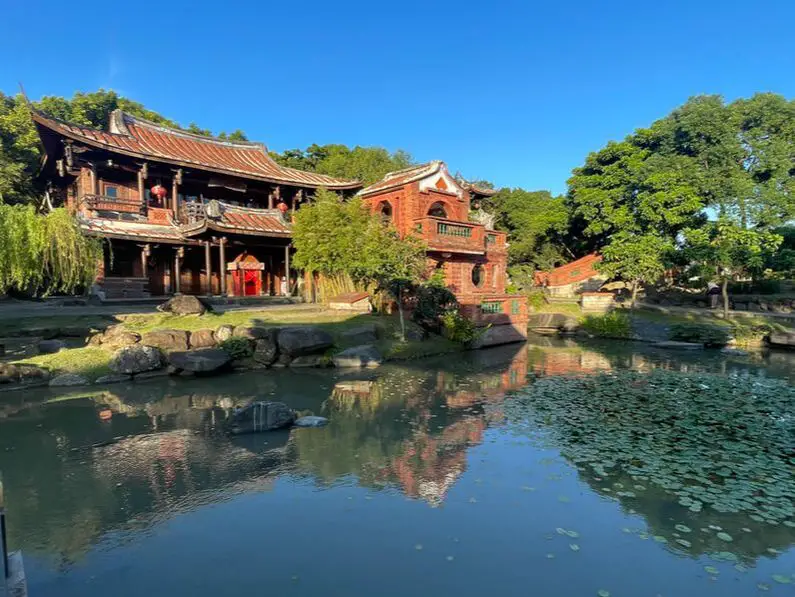
The Lin An Historical House and Museum is one of the most beautiful areas in Taiwan. In fact, its beauty is enough to rival the Forbidden City in Beijing. This group of historical buildings has been wonderfully preserved and also has been surrounded by gorgeous Chinese gardens. It should definitely be on your list of places to visit in Taipei.
Background: The Lin An Historical House was originally built around 1820. The family originally migrated from Quanzhou, Fujian, and made a living as traders at Dadaocheng, running the Rong Tai Store. After becoming rich, the family built several houses in the area. By 1978, the main building was in a dilapidated state on Siwei Road in Da An District of Taipei. It was also at risk of demolition due to the Dunhua Road expansion project. After petitions from locals, the building was relocated to its current location in Taipei Expo Park and opened to the public in 2000. The Lin An Historical House lies within the Taipei Expo Park, which was created in 2010 for the Taipei International Flora Exhibition which ran from November 2010 to April 2011. It used land from Yuanshan Park, Fine Arts Park, Xinsheng Park, and Dajia Riverside Park. Before the three parks were built, it was home to the former Taipei Children's Park and former Taipei Yuanshan Zoo, old military housing and military complexes, farmland, and a driver's education course. Usually, the house is busy on weekends. Hours: Tuesday to Sunday, 9 AM to 5 PM Price: Free Tours: You can book a tour of Taipei on Tripadvisor here, KKday here or Klook here. Hotels in Taipei: We have stayed at and recommend the Yuanshan Grand Hotel, once the tallest building in Taiwan and still the most grand (book on Booking.com here, Tripadvisor here, or Agoda here). We have stayed at and also recommend Fu Chang Hotel in Ximending, which is within walking distance of Ximending shopping district (book on Booking.com here, Tripadvisor here, or Agoda here). Looking for a hotel? We recommend booking through Booking.com here, which provides the best quality selection of accommodation in Taiwan. Find out where to stay in our Taiwan hotels guide or search for the best hotel deals in Taiwan here. Looking for Chinese lessons? You can get a 10% discount on Chinese lessons from Tutor ABC, the best Chinese language learning program out there by using the promo code FOREIGNERS10. How to get there: By MRT: The closest MRT station is Yuanshan Station, and is about a 20 minute walk. However there are bus stations that are closer. You can also book an MRT travel pass on Klook here. By Car/Scooter: Driving or taking a scooter there can be hard because there is limited paid parking nearby. Looking for scooter rental in Taipei? You can search on Klook here or KKday here to search for options. You can also check out our scooter rental guide here. If you are looking for car rentals, you can also search Qeeq here, Klook here, or KKday here. You can also check out our car rental guide here. By Bicycle: Cycling is the best way to enjoy Taiwan's landscapes if you have the time and energy, however bikes are no allowed in the park. Looking for bicycle rentals in Taiwan? You can use Taiwan's many Youbike sharing stations, or search for rentals on KKday here, and search for tours on Klook here. You can also check out our Taiwan cycling guide here. You can also book a Sunset Riverside Bike Ride and Historical Tour, 4 Hour Cycling in Taipei, Ultimate 8-Hour Cycling City Tour, or Taipei City Bike Tour with Night Market Experience on TripAdvisor here. For more information, check out our Taiwan transportation guide here. Map: See below: 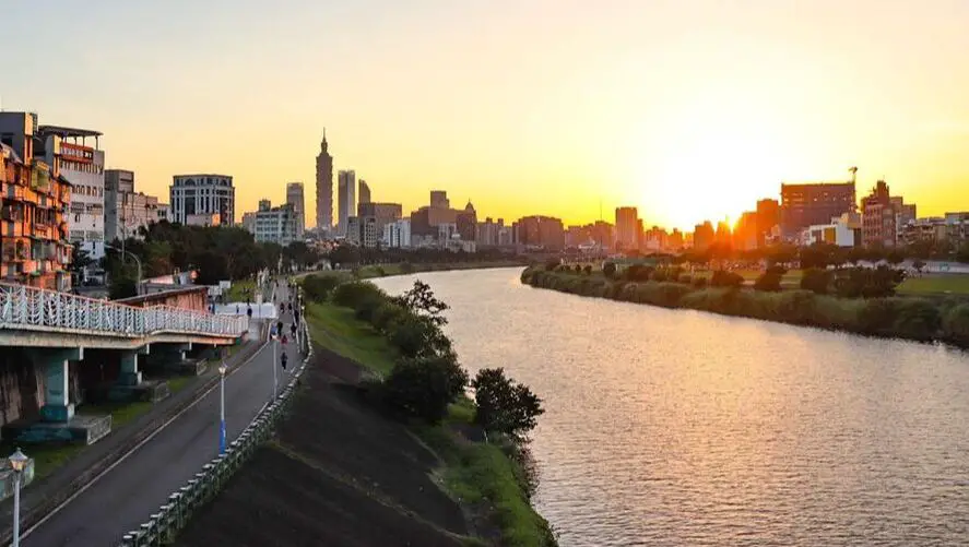
Chengmei Left Bank is one of the nicest areas along the Keelung River and provides an amazing view of the sunset and downtown Taipei. It is definitely worth a stop on your next trip to Nangang.
Background: The Chengmei Left Bank is named after Chengmei Changshou Bridge 成美長壽橋, one of the best preserved suspension bridges in Nangang, even though it is no longer a true suspension bridge. A few months ago we wrote a blog about the defunct suspension bridges along the Keelung River. This bridge also lies in the Nangang/Neihu stretch of the Keelung River and was also once a suspension bridge. Changshou Suspension Bridge was built at the end Xinming Road 452 Lane, and was the main bridge connecting Neihu, Zhoumei Neighborhood to Nangang and Songshan. In February 1948, construction was finished and Changshou Bridge and officially opened. The bridge was opened for the people of Zhoumei Neighborhood in order to improve the water-locked neighborhood. In October 1991 the bridge was restored to its current form and was named “Chengmei Changhsou Bridge.” The bridge now only allows foot traffic across the river. Hours: 24/7 Price: Free Tours: You can book a tour of Taipei on Tripadvisor here, KKday here or Klook here. Where to stay: High end: We have stayed at and recommend the Nangang Marriott (book on Booking.com here or Agoda here). We have also stayed at and recommend the Yuanshan Grand Hotel, once the tallest building in Taiwan and still the most grand (book on Booking.com here or Agoda here). Looking for a hotel? We recommend booking through Booking.com here, which provides the best quality selection of accommodation in Taiwan. Find out where to stay in our Taiwan hotels guide or search for the best hotel deals in Taiwan here. How to get there: By Car/Scooter: The bridge is within walking distance of Songshan MRT station. There is limited parking near the side of the road. Looking for scooter rental in Taipei? You can search on Klook here or KKday here to search for options. You can also check out our scooter rental guide here. If you are looking for car rentals, you can also search Qeeq here, Klook here, or KKday here. You can also check out our car rental guide here. By Bus/MRT: The bridge is within walking distance of Songshan MRT station. . There is limited parking near the side of the road. You can purchase a discount easy card to use on the MRT from Klook here or KKday here. You can also book an MRT travel pass on Klook here. By Bicycle: Cycling is the best way to enjoy Taiwan's landscapes if you have the time and energy. Looking for bicycle rentals in Taiwan? You can use Taiwan's many Youbike sharing stations, or search for rentals on KKday here, and search for tours on Klook here. You can also check out our Taiwan cycling guide here. You can also book a Sunset Riverside Bike Ride and Historical Tour, 4 Hour Cycling in Taipei, Ultimate 8-Hour Cycling City Tour, or Taipei City Bike Tour with Night Market Experience on TripAdvisor here. For more information, check out our Taiwan transportation guide here. Map: 
Chinese is considered the most spoken language in the world, and knowing it can help you build personal and business ties in Asia and throughout the world. However, before you start learning Chinese, it's important to get an understanding of the best resources available so that you can best use your time learning Chinese effectively. In this blog, we will introduce some of the best resources, such as books, apps, and other methods we have personally used to become proficient in Mandarin Chinese.
About the author: I am an American English native speaker who has been studying Chinese for almost two decades. I also hold a Bachelor's degree in Chinese and I know what it takes to become fluent in Mandarin as a native English speaker. 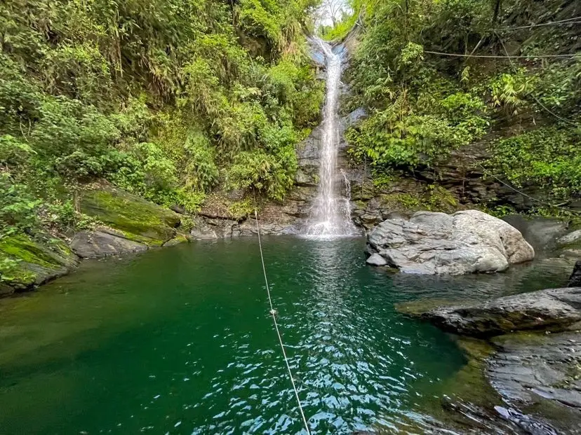
Wutan Waterfall (武潭瀑布) in Taiwu Township of Pingtung County is an easily accessible waterfall that is usually free of people. This area of mountains in southern Taiwan has almost unlimited swimmable waterfalls that are devoid of people. It is definitely a fun trip in the mountains that will not take too much time, and a great place to enjoy nature.
Background: Wutan Waterfall is about 20 meters high and features a large and deep swimming pool. It is named after Taiwu Village, which is an aboriginal village within walking distance down the hill. The holes in the rocks have been carved out of the rocks after thousands of years of erosion. There are stone steps along the side of the waterfall as well as ropes. The waterfall can get busy during holidays and weekends. Hours: 24/7 Price: Free Difficulty: Easy: 20 meters in length (one way) and 10 meters in elevation gain. The whole hike should take about two minutes from the road. Where to stay: Looking for a hotel? Find out where to stay in our Taiwan hotels guide or search for the best hotel deals in Taiwan here. We recommend booking through Agoda here, which provides the best quality selection of accommodation in Taiwan. I have stayed at many hostels and hotels in Pingtung, and even almost bought a house here. Some places that I have stayed at and can recommend are Nanwan Kiki (book on Agoda here, Booking.com here), a B&B next to Nanwan Bay, Kenting's most popular Beach. There are also a few decent hotels near Kenting Street Night Market like Kenting Star Inn 888 (book on Agoda here, Klook here, or Booking.com here), or Kenting Dajianshan Hotel (book on Agoda here or Booking.com here). You will notice that none of these hotels are five star resorts (I do not come to Kenting to waste my time at a resort, but you can still search Agoda, Booking.com, or Klook here for those) but they are in my opinion the above have the best value for the money. Tours: You can go book a river trace in Pingtung on Klook here or KKday here. How to get there: By Car/Scooter: From Pingtung, take Provincial Highway 1 souththeast until you reach Neipu and then turn southeast until you hit the 185. Drive until you reach Taiwu Village and turn up the mountain past the village to the waterfall. The waterfall is easy to find along the side of the road and there is some parking along the side of the road. Looking for scooter rental in Kenting? Click here or here to search for options. You can also check out our Taiwan scooter rental guide here. If you are looking for car rentals, you can also search Qeeq here, Klook here, or KKday here. You can also check out our car rental guide here. By Bus: You can take bus 8212 to Wutan, then it is about a 30 minute walk to the waterfall. You can book tickets to Pingtung via high speed rail (HSR) on Klook here or KKDay here, or book tickets via the normal train (TRA) on Klook here. You can book tickets to travel to Pingtung via inter-city bus on Klook here. By Bicycle: Cycling is the best way to enjoy Taiwan's landscapes if you have the time and energy. Looking for bicycle rentals in Taiwan? You can search on KKday here and search for tours on Klook here. You can also check out our Taiwan cycling guide here. Map: Please see below: 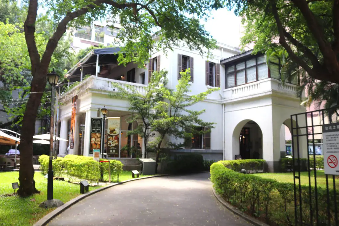
SPOT Taipei Film House (aka former Embassy of the United States, Taipei) is a former diplomatic building for the United States in Taiwan that has now been converted into a film house and café. Here you can enjoy the history of the building, as well as a cinema, art show, art shop, restaurant, and café. It is a great tourist stop in the heart of Taipei.
History The current building where the Taipei Film House currently lies was constructed in 1926 as the American Consulate in Taihoku during the Japanese rule of Taiwan. The consulate closed in 1941 due to WWII. After WWII, the US took the building back and renamed it the Consulate of the United States, Taipei. The building also served as the US Ambassador's residence. In 1953, the building was upgraded to an embassy. In 1957, a riot broke out and Taiwanese people stormed the embassy due to the alleged murder of an ROC national by an American. For more on this story, check out this podcast by Formosa Files. After The US switched recognition to the PRC in 1979, the building was left abandoned. The building was listed as a historic monument in 1997 and was renovated in 2000. The building now houses a cinema, coffee shop, restaurant, and gift shop. It is usually not very crowded. Hours: 11:00 AM to 10:00 PM Price: Free to visit Hotels in Taipei: We have stayed at and recommend the Yuanshan Grand Hotel, once the tallest building in Taiwan and still the most grand (book on Booking.com here, Tripadvisor here, or Agoda here). We have stayed at and also recommend Fu Chang Hotel in Ximending, which is within walking distance of Ximending shopping district (book on Booking.com here, Tripadvisor here, or Agoda here). Looking for a hotel? We recommend booking through Booking.com here, which provides the best quality selection of accommodation in Taiwan. Find out where to stay in our Taiwan hotels guide or search for the best hotel deals in Taiwan here. How to get there: By MRT/Bus: The building is close Zhongshan MRT station. You can also book an MRT travel pass on Klook here. By Bicycle: Cycling is the best way to enjoy Taiwan's landscapes if you have the time and energy. Looking for bicycle rentals in Taiwan? You can use Taiwan's many Youbike sharing stations, or search for rentals on KKday here, and search for tours on Klook here. You can also check out our Taiwan cycling guide here. You can also book a Sunset Riverside Bike Ride and Historical Tour, 4 Hour Cycling in Taipei, Ultimate 8-Hour Cycling City Tour, or Taipei City Bike Tour with Night Market Experience on TripAdvisor here. For more information, check out our Taiwan transportation guide here. By Car/Scooter: The building is just a few blocks north of Taipei Main Station on Zhongshan Road. There is limited parking nearby. Looking for scooter rental in Taipei? You can search on Klook here or KKday here to search for options. You can also check out our scooter rental guide here. If you are looking for car rentals, you can also search Qeeq here, Klook here, or KKday here. You can also check out our car rental guide here. Map: Please see below: 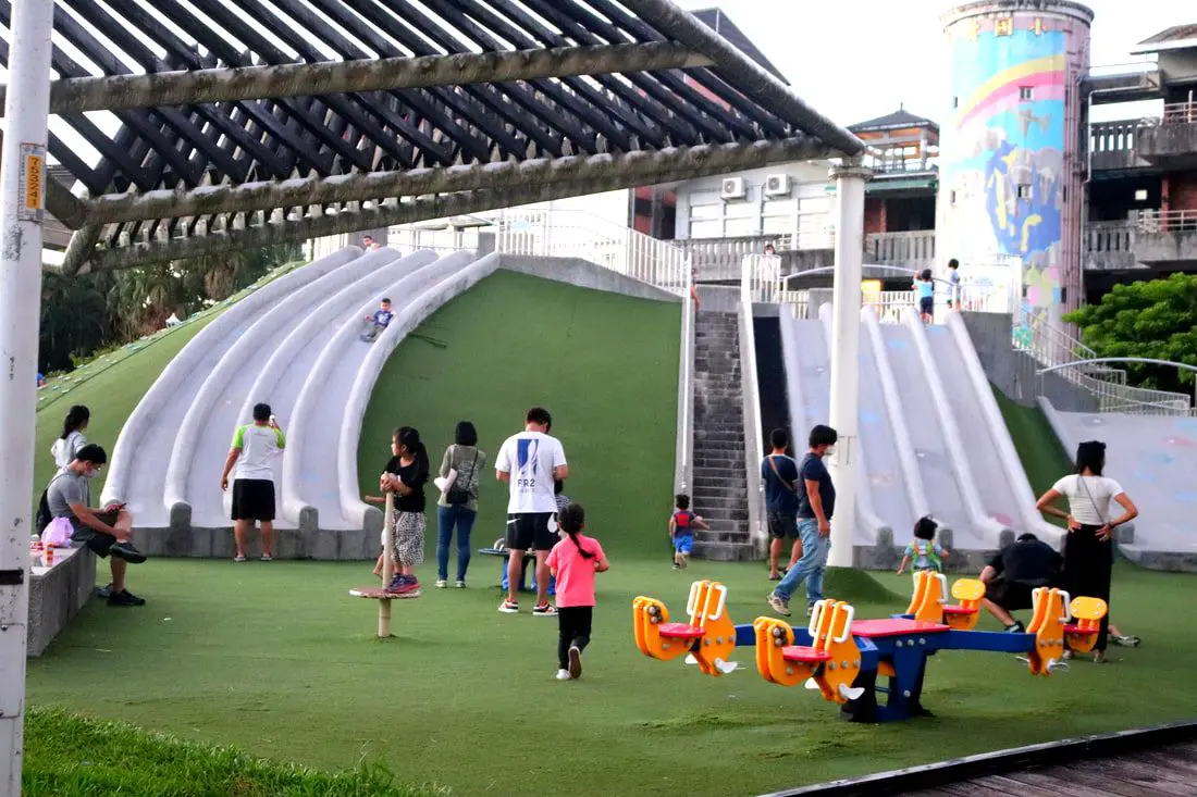
Baiyun Park is one of the most fun places for kids in East Taipei. With nine slides in total, as well as Taiwan's first circular swing set, a large sand pit, and a rock climbing area, this park has some of the best modern equipment around and simply beats out other parks in the area.
Background: Baiyun Park was completed in 2018 and is named after Baiyun Elementary School next door. This area of Xizhi, especially the mountain area is also known as Baiyun. We made a blog about Baiyun Police Station here. Before the Dakeng River Levee was built about 40 years ago, the area where Baiyun Park is located was part of the Dakeng River. Liufu and Xingfu Parks on the other side of the Levee were once also part of the Dakeng Riverbed. Baiyun Park was the first park in Taiwan with a circular swing set. Another unique feature is the paper airplane-shaped shading below the slides. Since its inception, Baiyun Park has been known as the funnest park around. There will be sure to be lots of kids and parents here on the weekends. Hours: 6 AM to 8 PM Tuesday to Sunday Price: Free Tours: You can book a tour of Taipei on Tripadvisor here, KKday here or Klook here. Where to stay: High end: We have stayed at and recommend the Nangang Marriott (book on Booking.com here or Agoda here). We have also stayed at and recommend the Yuanshan Grand Hotel, once the tallest building in Taiwan and still the most grand (book on Booking.com here or Agoda here). Looking for a hotel? We recommend booking through Booking.com here, which provides the best quality selection of accommodation in Taiwan. Find out where to stay in our Taiwan hotels guide or search for the best hotel deals in Taiwan here. Activities in Nangang: You can take 14% off the buffet at Courtyard Marriot Nangang on KKday here. You can also get a discount ticket to Crazy Car Café in Nangang, the only restaurant in Taiwan that offers Go-Karting, on KKday here. How to get there: By Car/Scooter: The park is within walking distance of Nangang Exhibition Center MRT station. There is no car parking near the side of the road, only scooter parking. Looking for scooter rental in Taipei? You can search on Klook here or KKday here to search for options. You can also check out our scooter rental guide here. If you are looking for car rentals, you can also search Qeeq here, Klook here, or KKday here. You can also check out our car rental guide here. By Bus/MRT: The park is within walking distance of Nangang Exhibition Center MRT station. There is limited parking near the side of the road. You can purchase a discount easy card to use on the MRT from Klook here or KKday here. You can also book an MRT travel pass on Klook here. By Bicycle: Cycling is the best way to enjoy Taiwan's landscapes if you have the time and energy. Looking for bicycle rentals in Taiwan? You can use Taiwan's many Youbike sharing stations, or search for rentals on KKday here, and search for tours on Klook here. You can also check out our Taiwan cycling guide here. You can also book a Sunset Riverside Bike Ride and Historical Tour, 4 Hour Cycling in Taipei, Ultimate 8-Hour Cycling City Tour, or Taipei City Bike Tour with Night Market Experience on TripAdvisor here. For more information, check out our Taiwan transportation guide here. Map: See below: 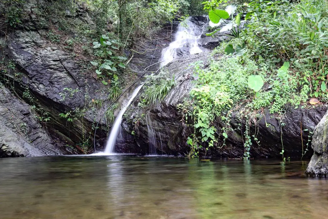
Koushe Waterfall (口社瀑布) near Koushe Village in Gaoshu Township of Pingtung is an easily accessible, swimmable waterfall right next to the side of the road. This area of mountains in southern Taiwan has almost unlimited swimmable waterfalls that are devoid of people. It is definitely a fun trip in the mountains that will not take too much time, and a great place to enjoy nature.
Background: Koushe Waterfall is about 12 meters high and features a large swimming pool. It is named for Koushe Village, which is an aboriginal village within walking distance down the hill. The holes in the rocks have been carved out of the rocks after thousands of years of erosion, and there is a rope climb and trail along the side of the waterfalls, which can be climbed in just a few minutes. Hours: 24/7 Price: Free Difficulty: Easy: 20 meters in length (one way) and 10 meters in elevation gain. The whole hike should take about two minutes from the road. Accommodation: Looking for a hotel? Find out where to stay in our Taiwan hotels guide or search for the best hotel deals in Taiwan here. We recommend booking through Agoda here, which provides the best quality selection of accommodation in Taiwan. I have stayed at many hostels and hotels in Pingtung, and even almost bought a house here. Some places that I have stayed at and can recommend are Nanwan Kiki (book on Agoda here, Booking.com here), a B&B next to Nanwan Bay, Kenting's most popular Beach. There are also a few decent hotels near Kenting Street Night Market like Kenting Star Inn 888 (book on Agoda here, Klook here, Hotels.com here, Expedia here, or Booking.com here), or Kenting Dajianshan Hotel (book on Agoda here, Booking.com here, Hotels.com here, or Expedia here). You will notice that none of these hotels are five star resorts (I do not come to Pingtung to waste my time at a resort, but you can still search Agoda, Booking.com, Hotels.com, or Expedia for those) but they are in my opinion the above have the best value for the money. Tours: You can go book a river trace in Pingtung on Klook here or KKday here. How to get there: By Car/Scooter: From Pingtung, take Provincial Highway 27 northeast until you reach Gaoshu and then turn southeast until you hit the 185. Drive until you reach Koushe Village and turn up the mountain just before the village. The waterfall is easy to find along the side of the road. Looking for scooter rental in Kenting? Click here or here to search for options. You can also check out our Taiwan scooter rental guide here. If you are looking for car rentals, you can also search here. You can also check out our car rental guide here. By Bus: There is no public transportation to this area. Consider taking a taxi or renting a vehicle. You can book tickets to Pingtung via high speed rail (HSR) on Klook here or KKDay here, or book tickets via the normal train (TRA) on Klook here. You can book tickets to travel to Pingtung via inter-city bus on Klook here. By Bicycle: Cycling is the best way to enjoy Taiwan's landscapes if you have the time and energy. Looking for bicycle rentals in Taiwan? You can search on KKday here and search for tours on Klook here. You can also check out our Taiwan cycling guide here. Map: Please see below: 
Learning Mandarin Chinese can be a difficult task, especially for Westerners. It has often been ranked as one of the hardest languages in the world for English native speakers to learn. However, with these tips you should be on your way to learning fluent Chinese.
Below is a list of ten steps to master Mandarin Chinese. About the author: I am an American English native speaker that has been studying Chinese for almost two decades. I also hold a Bachelor's degree in Chinese and I know what it takes to become fluent in Mandarin as a native English speaker. Let's get this list started! 
Tax season is here. In Taiwan, taxes must be filed before May 31st. As a foreigner, you might be wondering how to file a tax return and what the regulations are. Luckily Taiwan has made it easy by creating an online tax filing system that you can complete from your computer, although you do still have to physically send some forms to the tax office. Let us answer some common questions about tax filing that might come up:
Forward: The following is Q+A for tax year 2023 only, based on information provided on Taiwan's Ministry of Finance website for your reference only. Personal income tax can be a complicated issue; for specific answers regarding your tax situation please contact the Taiwan tax office: +886-2-2311-3711. Press 7 for English service. The ultimate decision for tax payable is up to the discretion of the Taiwan tax office. Q: When should I file Taxes? A: Between May 1st to May 31st after the tax year (tax year is same as calendar year). If you are leaving the country and do not plan to return to Taiwan, you must file an early tax return within 10 days before you leave. We recommend going to the tax office in person for an early filing. Q: When are Taiwan tax payments due? A: Tax payments are due by May 31st, after which there will be penalties for late payments. Q: What makes me eligible for paying Taiwan taxes (or what makes me a tax resident)? A: You become a Taiwan tax resident if you stay in Taiwan longer than 183 days, or if you are a Taiwan national and have household registration (戶籍) in Taiwan and visit for at least one day. The address in your ARC is not household registration, it's a registration process from the local administrative office (戶政事務所). If you stay less than 90 days in Taiwan, in general, you do not have to file taxes, and VAT or sales taxes are reimbursable. If you worked in Taiwan and stayed over 90 days but less than 183 days, you need to pay taxes on your Taiwan-based salary even if your income came from overseas, and you will pay a fixed rate of 6% or 18% income tax (your company may have deducted this from your salary already). If you have Taiwanese dual citizenship and Taiwanese house registration, then you need to pay taxes if you have stayed in Taiwan for over 31 days. Days are cumulative in a tax year, and it doesn't matter what you came for during these days. Q: How do I count the days I stayed in Taiwan? A: Please note that the day you come to Taiwan doesn't count, but the day you leave does. It's a good idea to keep track of the number of days you have been in Taiwan via the stamps on your passport. Q: What is the income tax rate?/ How much is Taiwan tax? A: The income tax rate for non-residents who earn at least 1.5 the minimum wage per month (39,600 NT as of 2023) is 18% (you can get a tax refund if you pay 18% taxes and then become a tax resident). 18% usually is applicable to white-collar foreign workers. For non-residents who earn less than 1.5 the minimum wage per month (39,600 NT as of 2023), the income tax rate is 6% (you can get a tax refund if you pay 6% taxes and then become a tax resident). 6% is usually applicable to most blue-collar foreign workers. The 2023 tax rate for residents (staying over 183 days in Taiwan) is as follows (source: Taiwan Ministry of Finance):
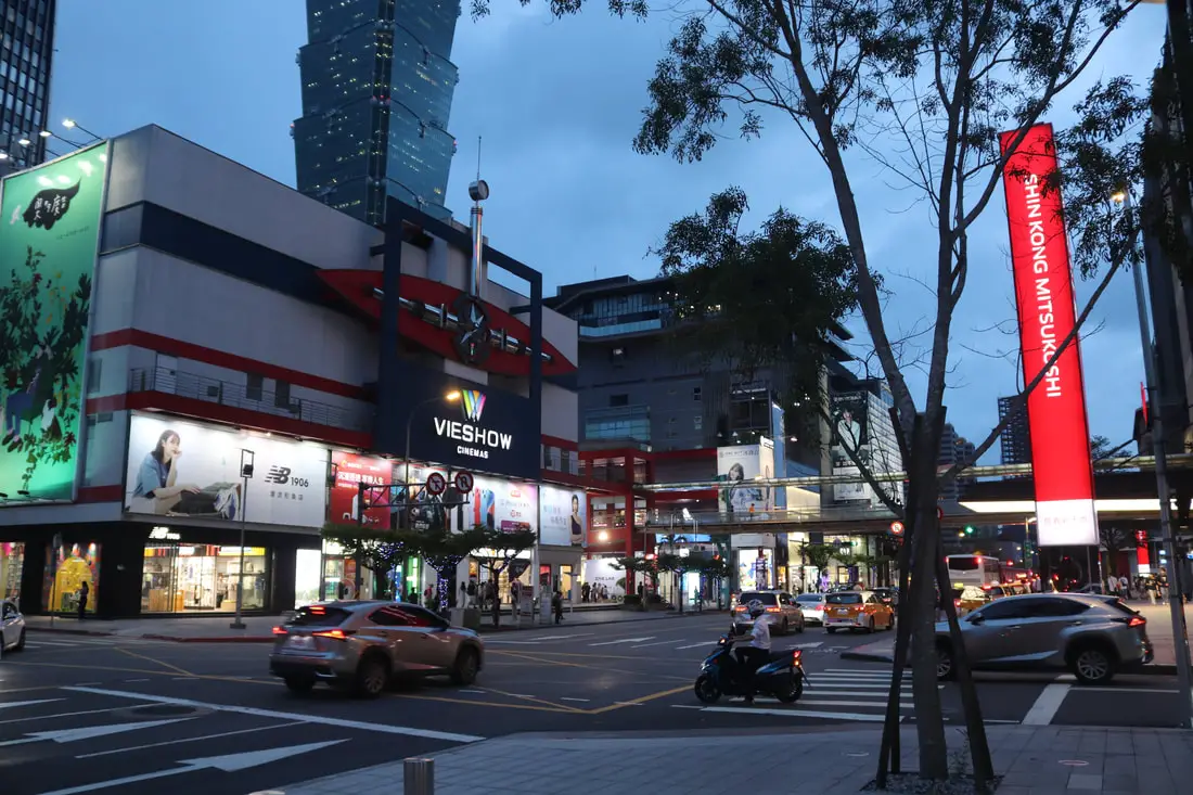
With multiple skyscrapers, upscale shopping malls, international restaurants, hotels, cinemas, and more, Xinyi Shopping District in Taipei is known as the Manhattan of Taiwan, and the world's densest commercial district. It has also become a financial center with many companies creating their Taiwan headquarters here. It is also a great place for visitors to shop and enjoy the most vibrant part of Taipei.
Background: Xinyi Shopping District is roughly the area of Xinyin Planning District (信義計畫區) which was designed in the 1970s. Before that time, the area was mainly empty fields for farming. The goal of the plan was to ease pressure off of the old crowded city center around Ximending and Taipei Station. The area is over 153 Hectares and includes 15 department stores, including Shin Kong Mitsukoshi, Taipei 101 Mall, Xinyi Breeze, and more, making it the world's densest commercial district. Hours: Most department stores are open from 11 AM to 10 PM. Price: Free Hotels in Taipei: High end: We have stayed at and recommend the Yuanshan Grand Hotel, once the tallest building in Taiwan and still the most grand (book on Booking.com here, Tripadvisor here, or Agoda here). We have also stayed at and recommend the Grand Hyatt (book on Booking.com here, Tripadvisor here, Agoda here, or Hotels.com here), Marriot (book on Booking.com here, Tripadvisor here, Agoda here, or Hotels.com here), Sheraton (book on Booking.com here, Tripadvisor here, Agoda here, or Hotels.com here), Shangri-la (book on Booking.com here, Tripadvisor here, Agoda here, or Hotels.com here), and Regent (book on Booking.com here, Tripadvisor here, Agoda here, or Hotels.com here), which are all very high quality hotels in the middle of Taipei City. We also recommend Fullon Hotel which has locations in Tamsui and Fulong near the beach (book on Booking.com here, Tripadvisor here, Agoda here, or Hotels.com here). Budget Hotels: We have stayed at and also recommend Fu Chang Hotel in Ximending, which is within walking distance of Ximending shopping district (book on Booking.com here, or Agoda here). We have also stayed at and recommend Hai Xia Your Home which is right in front of Fulong Beach (book on Booking.com here, Tripadvisor here, Agoda here, or Hotels.com here). Looking for a hotel? We recommend booking through Booking.com here, which provides the best quality selection of accommodation in Taiwan. Find out where to stay in our Taiwan hotels guide or search for the best hotel deals in Taiwan here. Attractions in Taipei: There are many attractions that you can enjoy in Taipei such as Taipei 101 Observatory, Taipei 101 460 Skyline Observatory, Taipei Children's Amusement Park, Maokong Gondola, National Palace Museum, Yehliu Ocean World, Yehliu Geopark, National Museum of Marine Science and Biology, i-ride 5D cinema, Astronomical Museum, Miniatures Museum of Taiwan, Double Decker Sightseeing Bus, Miramar Ferris Wheel Ticket, Taipei Zoo, Heping Island Park, Ju Ming Museum, Yuanshan Hotel Secret Road, National Taiwan Museum, New Taipei Gold Museum, Futian Leisure Farm, Chiang Kai-shek Shilin Residence, Chi Po-lin Museaum, Beitou Museum, Tsao Wonderland, Railway Museum, Fort San Domingo, 13 Levels Archaeology Museum, Austin Land, Museum of World Religions, Formosan Aboriginies Museum, ASE Parent-child Park, teamLab Future Park, Yukids Island, VR Experience, Bat Cave, Neidong Waterfall, Candlestick Islet, Jurassic Snow Park, Zhonghe High5 Amusement Park, Longshan Temple, Xingtian Temple, Ningxia Night Market, Yansan Night Market, Meteor Garden, Yingge Old Street, and many more attractions on Tripadvisor here, Klook here, or KKday here. Activities in Taipei: Don't forget that there are many activities available in Taipei such as Indoor Skiing, Rock Climbing, Hiking, Wakeboarding, Surfing, Speedboat Surfing, SUP / Paddle Boarding, Diving, Snorkeling Kayaking, Canoeing, Water Biking, River Tracing / Canyoneering, ATVing, Horse Riding, Cooking Class, Archery, Ice Skating, Roller Skating, Tree Climbing, Urban Camping, Glamping, Motorcycling, Motorbike Tour, Dragon Boat Racing, Escape Room, Shen'ao Rail Bike, Laser Gun Experience, Batting Cages, Bowling, Paintball, Flight Simulation Experience, Taipei Tram Driving Experience, Rail Simulation Experience, Taipei 101 Observation Deck activity, Strawberry Picking, Professional Photo Shoot, Body Relaxation SPA, Night Tour, Calligraphy Workshop, and more on Tripadvisor here, Klook here, or KKday here. How to get around in Taipei: Taipei's transportation system is convenient and safe. There are many options you can consider to get around in Taipei below: By Train: Gets you to the city center of all major cities in Taiwan. It is about 800NT to get from Taipei to Kaohsiung. Roughly half the price of the HSR. Book tickets via the normal train (TRA) on Klook here. By HSR: (High-Speed Rail) – Gets you quickly from north to south. Besides Taipei and Kaohsiung, most of the stations are far from city centers. It costs about 1500NT to get from Taipei to Kaohsiung. You can book tickets to the high-speed rail (HSR) on Klook here or KKDay here. By MRT: (Mass Rapid Transit, Metro train, subway) – Easily gets you around Taipei and Kaohsiung. You can purchase a discount easy card to use on the MRT from Klook here or KKday here. You can also book an MRT travel pass on Klook here. By Bus: Buses can be tricky. Long-range buses such as Ubus and King Bus are easier to understand and cheaper than the local train. They can take you to the city center of every city throughout Taiwan and to remote tourist destinations such as sun moon lake. A long-range bus from Taipei to Kaohsiung is about 500 NT. You can also book tickets to travel to Shifen via inter-city bus on Klook here. You can also book a Taipei Sightseeing: Hop On, Hop Off Open Top Bus on TripAdvisor here. By Taxi: You can take short rides for about 150 NT, or hire a Taxi for a day for around 150 USD. By Car: If you are looking for car rentals, you can also search Qeeq here, Klook here, or KKday here. You can also check out our car rental guide here. By Scooter: Looking for scooter rental in Taipei? You can search on Klook here or KKday here to search for options. You can also check out our scooter rental guide here. By Bicycle: Cycling is the best way to enjoy Taiwan's landscapes if you have the time and energy. Looking for bicycle rentals in Taiwan? You can use Taiwan's many Youbike sharing stations, or search for rentals on KKday here, and search for tours on Klook here. You can also check out our Taiwan cycling guide here. ​You can also book a Sunset Riverside Bike Ride and Historical Tour, 4 Hour Cycling in Taipei, Ultimate 8-Hour Cycling City Tour, or Taipei City Bike Tour with Night Market Experience on TripAdvisor here. For more information, check out our Taiwan transportation guide here. Map: See below: 
Shanshuilu Eco Park (aka Shanshui Green Eco Park) in Nangang District of Taipei is a large grassy park with one of the best views in Taipei City, built over a former landfill. Here you can find beautiful mountain scenery, a large playground, ziplines, a sand pit, a reading room, and lots of large grassy areas. It is one of the most popular parks in Taipei City.
Background: Shanshuilu Eco Park was built over the Shanzhuku Landfill and opened to the public in 2013. The park is 21 hectares and it is the largest park in Nangang. The Shanzhuku Valley once had steep terrain, and used to be used for orchards and farmland. However, since about 1970, the valley was slowly filled in with landfill and a recycling plant, acting as Taipei City's main landfill site. Garbage stopped being collected after the site was filled to capacity in 2004, and the site was used as a recycling site until 2010. After 2010, it was decided to turn the site into a park. Behind the park, part of the landfill is still in use and has renewed its permit until 2030 or until the site fills. The park features a small library and classroom, bathrooms, slides, two sand pits, ponds, bike paths, large grassy areas, an amphitheater, swings, trampolines, and zip-lines. Because of its large size and fun equipment, it is especially popular for families with small children and parking will usually get totally full on weekends with good weather. Dogs are allowed at the park. Hours: 6 AM to 8 PM Tuesday to Sunday Price: Free Tours: You can book a tour of Taipei on Tripadvisor here, KKday here or Klook here. Where to stay: High end: We have stayed at and recommend the Nangang Marriott (book on Booking.com here or Agoda here). We have also stayed at and recommend the Yuanshan Grand Hotel, once the tallest building in Taiwan and still the most grand (book on Booking.com here or Agoda here). Looking for a hotel? We recommend booking through Booking.com here, which provides the best quality selection of accommodation in Taiwan. Find out where to stay in our Taiwan hotels guide or search for the best hotel deals in Taiwan here. How to get there: By Car/Scooter: The park is just off Nanshen Road between Nangang and Shenkeng. There is plenty of free parking within the park. The parking spots may get full on weekends but you can still park next to the curb on the east side of the parking lot. Looking for scooter rental in Taipei? You can search on Klook here or KKday here to search for options. You can also check out our scooter rental guide here. If you are looking for car rentals, you can also search Qeeq here, Klook here, or KKday here. You can also check out our car rental guide here. By Bus/MRT: From Nangang Exhibition Center MRT station you can take bus 679 to the park. There is limited parking near the side of the road. You can purchase a discount easy card to use on the MRT from Klook here or KKday here. You can also book an MRT travel pass on Klook here. By Bicycle: Cycling is the best way to enjoy Taiwan's landscapes if you have the time and energy. Looking for bicycle rentals in Taiwan? You can use Taiwan's many Youbike sharing stations, or search for rentals on KKday here, and search for tours on Klook here. You can also check out our Taiwan cycling guide here. You can also book a Sunset Riverside Bike Ride and Historical Tour, 4 Hour Cycling in Taipei, Ultimate 8-Hour Cycling City Tour, or Taipei City Bike Tour with Night Market Experience on TripAdvisor here. For more information, check out our Taiwan transportation guide here. Map: 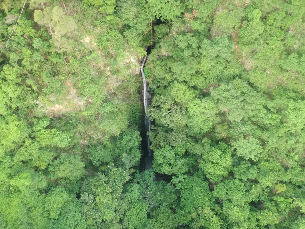
Dajin Waterfall is a large waterfall in Gaoshu township of Pingtung County. The hike here is relatively easy along a paved path, and there are great views of Pingtung along the way. It is definitely a fun trip in the mountains that will not take too much time, and a great place to enjoy nature.
Background: Dajin Waterfall is about 20 meters high, and falls at about 90 degrees. and its name comes from the roughly seven holes in the rocks between waterfalls. The holes in the rocks have been carved out of the rocks after thousands of years of erosion, and there is a rope climb and trail along the side of the waterfalls, which can be climbed in less than an hour. Currently the nearest parking lot lies on private property and the property owner collects parking fees in cash. Hours: 24/7 Price: Free Difficulty: Easy: 1 KM in length (one way) and 100 meters in elevation gain. The whole hike should take about an hour. Where to stay: Looking for a hotel? Find out where to stay in our Taiwan hotels guide or search for the best hotel deals in Taiwan here. We recommend booking through Agoda here, which provides the best quality selection of accommodation in Taiwan. I have stayed at many hostels and hotels in Pingtung, and even almost bought a house here. Some places that I have stayed at and can recommend are Nanwan Kiki (book on Agoda here, Booking.com here), a B&B next to Nanwan Bay, Kenting's most popular Beach. There are also a few decent hotels near Kenting Street Night Market like Kenting Star Inn 888 (book on Agoda here, Klook here, or Booking.com here), or Kenting Dajianshan Hotel (book on Agoda here or Booking.com here). You will notice that none of these hotels are five star resorts (I do not come to Kenting to waste my time at a resort, but you can still search Agoda, Booking.com, or Klook here for those) but they are in my opinion the above have the best value for the money. Tours: You can go book a river trace in Pingtung on Klook here or KKday here. How to get there: By Car/Scooter: From Pingtung, take Provincial Highway 27 northeast until you reach Xinfeng Village in Gaoshu and then turn southeast until you hit the mountains. Drive to the end of the road and that is where the trailhead starts. Looking for scooter rental in Kenting? Click here or here to search for options. You can also check out our Taiwan scooter rental guide here. Looking for scooter rental in Pingtung? Click here or here to search for options. If you are looking for car rentals, you can also search Qeeq here, Klook here, or KKday here. You can also check out our car rental guide here. By Bus: You can take bus 8218 bus to Weiliao Station, but then it is a 30 minute walk to the trailhead. You can book tickets to Pingtung via high speed rail (HSR) on Klook here or KKDay here, or book tickets via the normal train (TRA) on Klook here. You can book tickets to travel to Pingtung via inter-city bus on Klook here. By Bicycle: Cycling is the best way to enjoy Taiwan's landscapes if you have the time and energy. Looking for bicycle rentals in Taiwan? You can search on KKday here and search for tours on Klook here. You can also check out our Taiwan cycling guide here. Map: Please see below: 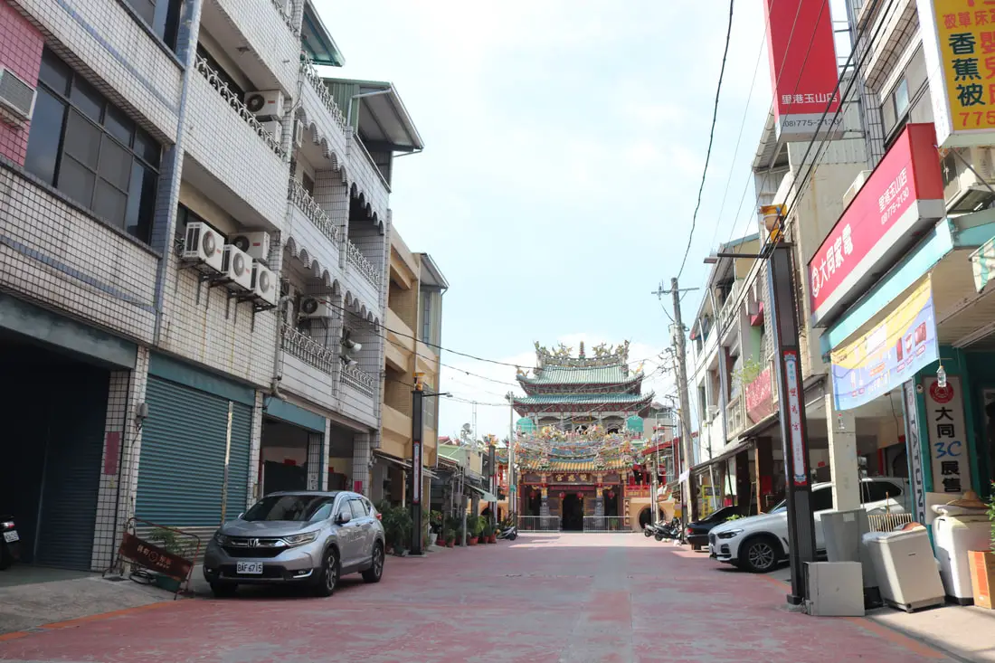
Ligang Old Street is a historical small town in rural Pingtung dating back to the Qing Dynasty. At one time it even had a city wall built around it. Here you can find historical buildings are religious sites without any other tourists bothering you. There is also a night market and morning wet market to explore. It is definitely worth a visit on your next trip to Pingtung.
Please note this is referring to the old street in Pingtung. For the old street in Changhua, see our blog on Lukang Old Street here. Background: For millennia Pingtung had been inhabited by plains aboriginal groups. Their biggest settlement was called Ahou, on the current site of Pingtung City, and another settlement to the northwest along the Gaoping River was called Aligang, which is where Ligang gets its name. The first Chinese settlers came to the area in the late 1600s during the Kingdom of Tungming and Qing Dynasty. Before that time, the area was known as a place of exile for Chinese criminals. During the Qing Dynasty, the area was part of Fengshan County. During these times there were often fights among local clans such as Hakka, Cantonese, and Min peoples that came from different parts of China. For protection against rebellions, a city wall was built around Ligang, but was later destroyed during the Japanese Era. The Japanese also relocated two villages that were close to the Gaoping River near Ligang Old Street. Currently, the population of Ligang is roughly 25,000 people, a number which has remained constant for nearly 60 years. Normally there are not many people on the old street and the area is not very busy. Hours: Ligang Old Street: 24/7 Ligang Night Market (里港夜市): 5 PM - 10:30 PM Thursday and Sunday evenings Ligang Morning Vegetable Market (里港市場): 8 AM - 12 PM Tuesday - Sunday Price: Free Tours and Activities in Pingtung: There are many activities available in Pingtung, such as snorkeling, diving, SUPing, surfing, submarine riding, and river tracing. You can find more tours of Kenting on Klook here or KKday here. Where to stay: Looking for a hotel? Find out where to stay in our Taiwan hotels guide or search for the best hotel deals in Taiwan here. We recommend booking through Agoda here, which provides the best quality selection of accommodation in Taiwan. I have stayed at many hostels and hotels in Pingtung, and even almost bought a house here. Some places that I have stayed at and can recommend are Nanwan Kiki (book on Agoda here, Booking.com here), a B&B next to Nanwan Bay, Kenting's most popular Beach. There are also a few decent hotels near Kenting Street Night Market like Kenting Star Inn 888 (book on Agoda here, Klook here, or Booking.com here), or Kenting Dajianshan Hotel (book on Agoda here or Booking.com here). You will notice that none of these hotels are five star resorts (I do not come to Kenting to waste my time at a resort, but you can still search Agoda, Booking.com, or Klook here for those) but they are in my opinion the above have the best value for the money. How to get there: By Car/Scooter: Take Provincial Highway 22 East from Kaohsiung to Pingtung until you reach Ligang. From National Highway 3, you can also get off the 391 exit to Jiuru and head north just about 1 KM to Ligang. The Confucius Temple is on Shengli Road in the middle of the city. Looking for scooter rental in Pingtung? Click here or here to search for options. If you are looking for car rentals, you can also search Qeeq here, Klook here, or KKday here. You can also check out our car rental guide here. By Bus: You can reach Ligang from Pingtung Bus 8220 or 8217. You can book tickets to Kaohsiung via high speed rail (HSR) on Klook here or KKDay here, or book tickets via the normal train (TRA) on Klook here. You can book tickets to travel to Pingtung via inter-city bus on Klook here. By Bicycle: Cycling is the best way to enjoy Taiwan's landscapes if you have the time and energy. Looking for bicycle rentals in Taiwan? You can search on KKday here and search for tours on Klook here. You can also check out our Taiwan cycling guide here. Map: Please see below: 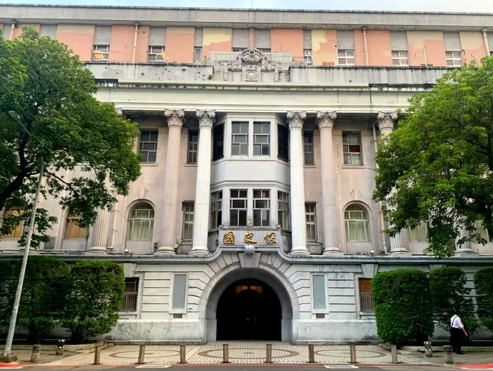
Academia Historica is a public history museum focusing on the political history of Taiwan's presidents and vice presidents, as well as other cultural and ecological exhibitions, located in Taipei. One of the many historical buildings in Taipei, is a beautiful Japanese-era marble-faced building, the former communications bureau, which has been converted into a museum for Taiwan's former presidents. It is open for tours to the public on weekdays and is definitely worth a visit.
History The current building where Academia Historica Taipei currently lies was constructed in 1914 during the Japanese rule of Taiwan for the Communications Bureau, Transportation Department of the Japanese Colonial Government. It now hosts exhibits for Taiwan's presidents and vice presidents. Academia Historica is also an institution that was established in 1947 by the ROC government in Nanking. In 1957 it reopened in Taiwan. It moved to the current building, and also has other departments in Xindian and Nantou. The Nantou Building has since changed its name to Taiwan Historica (there is a much bigger museum now in Nantou). The Taipei building, which this blog covers, holds artifacts from the president and vice president of Taiwan (R.O.C.). Hours: The office is open for visitors from Monday to Friday 9:00 AM to 4:30 PM Price: Free Hotels in Taipei: We have stayed at and recommend the Yuanshan Grand Hotel, once the tallest building in Taiwan and still the most grand (book on Booking.com here, Tripadvisor here, or Agoda here). We have stayed at and also recommend Fu Chang Hotel in Ximending, which is within walking distance of Ximending shopping district (book on Booking.com here, Tripadvisor here, or Agoda here). Looking for a hotel? We recommend booking through Booking.com here, which provides the best quality selection of accommodation in Taiwan. Find out where to stay in our Taiwan hotels guide or search for the best hotel deals in Taiwan here. How to get there: By MRT/Bus: The building is close to the NTU hospital MRT station. You can also book an MRT travel pass on Klook here. By Bicycle: Cycling is the best way to enjoy Taiwan's landscapes if you have the time and energy. Looking for bicycle rentals in Taiwan? You can use Taiwan's many Youbike sharing stations, or search for rentals on KKday here, and search for tours on Klook here. You can also check out our Taiwan cycling guide here. You can also book a Sunset Riverside Bike Ride and Historical Tour, 4 Hour Cycling in Taipei, Ultimate 8-Hour Cycling City Tour, or Taipei City Bike Tour with Night Market Experience on TripAdvisor here. For more information, check out our Taiwan transportation guide here. By Car/Scooter: There is limited parking nearby. Looking for scooter rental in Taipei? You can search on Klook here or KKday here to search for options. You can also check out our scooter rental guide here. If you are looking for car rentals, you can also search Qeeq here, Klook here, or KKday here. You can also check out our car rental guide here. Map: Please see below: 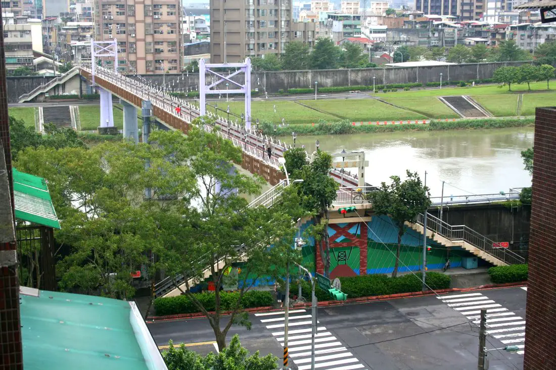
Chengmei Bridge Changshou is one of the best preserved suspension bridges in Nangang, even though it is no longer a true suspension bridge. A few months ago we wrote a blog about the defunct suspension bridges along the Keelung River. This bridge is also lies in the Nangang/Neihu stretch of the Keelung River and was also once a suspension bridge, so I feel it deserves a blog as well.
Hours: 24/7 Price: Free Hotels in Taipei: High end: We have stayed at and recommend the Nangang Marriot (book on Booking.com here or Agoda here). We have also stayed at and recommend the Yuanshan Grand Hotel, once the tallest building in Taiwan and still the most grand (book on Booking.com here or Agoda here). Looking for a hotel? We recommend booking through Booking.com here, which provides the best quality selection of accommodation in Taiwan. Find out where to stay in our Taiwan hotels guide or search for the best hotel deals in Taiwan here. Activities in Nangang: You can take 14% off the buffet at Courtyard Marriot Nangang on KKday here. You can also get a discount ticket to Crazy Car Café in Nangang, the only restaurant in Taiwan that offers Go-Karting, on KKday here. How to get there: By Car/Scooter: The bridge is within walking distance of Songshan MRT station. There is limited parking near the side of the road. Looking for scooter rental in Taipei? You can search on Klook here or KKday here to search for options. You can also check out our scooter rental guide here. If you are looking for car rentals, you can also search Qeeq here, Klook here, or KKday here. You can also check out our car rental guide here. By Bus/MRT: The bridge is within walking distance of Songshan MRT station. . There is limited parking near the side of the road. You can purchase a discount easy card to use on the MRT from Klook here or KKday here. You can also book an MRT travel pass on Klook here. By Bicycle: Cycling is the best way to enjoy Taiwan's landscapes if you have the time and energy. Looking for bicycle rentals in Taiwan? You can use Taiwan's many Youbike sharing stations, or search for rentals on KKday here, and search for tours on Klook here. You can also check out our Taiwan cycling guide here. You can also book a Sunset Riverside Bike Ride and Historical Tour, 4 Hour Cycling in Taipei, Ultimate 8-Hour Cycling City Tour, or Taipei City Bike Tour with Night Market Experience on TripAdvisor here. For more information, check out our Taiwan transportation guide here. Map: 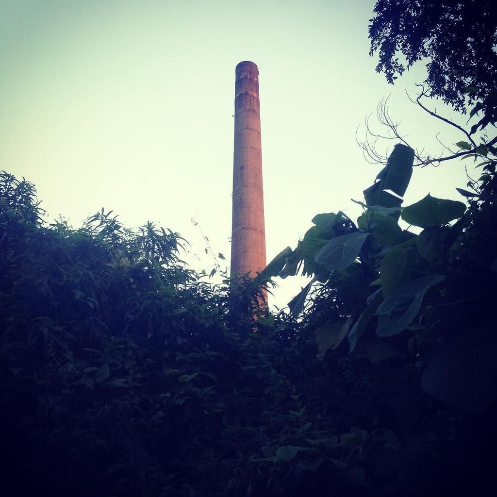
Songshan Brick Factory Smokestack 松山磚廠烟囪
History: Of the many smokestacks that once covered Nangang, only 3 remain standing, and there is another which is highly damaged. The first smokestack I will talk about is not very well known at all. In fact I only found one blog that mentions it, calling it "南港繁華的磚廠遺址," and there is also a facebook page that someone created for it, which has a pretty good history of the place. This factory is still in use as a banana field/garage. 歷史: 曾經覆蓋南港的煙囪中,只剩下3個,還有一被破損的煙囪。 我會說的第一個煙囪根本不是很有名。 其實我只找到一個提到它的部落格,稱它為“南港繁華的磚廠遺址”,還有人為它創建的Facebook頁面,這個頁面有很好的地方歷史。 這家工廠目前有香蕉場/車庫的作用。 To paraphrase from the Facebook page, the kiln was one of many brick kilns in the surrounding neighborhoods. After the tea industry began to decline in Nangang, brick making became the mainstay for the area. Clay was harvested from what is now Songshan station, which was ideal for brick making. There were smokestacks pretty much everywhere (making for terrible air quality), and pretty everyone that lived at what is now the border between Nangang an Songshan was involved in the brick making process in some way. There were roughly 50 workers at each brick kiln, earning roughly 200 NT a day. At the time, the brick kiln had the most advanced technology available and could produce 18,000-20,000 bricks a day! The quality was especially fine at the Bagua kiln (across the street from this one, now destroyed). The bricks from that kiln were crack resistant, and some were used in what is now the presidential office building in Taipei. 從Facebook的頁面來解釋,這個窯是周圍社區的眾多磚窯之一。 南港茶業開始衰落後,製磚成為該地區的中流砥柱。 從現在的松山車站收穫粘土,這是製磚的理想選擇。 幾乎到處都是煙囪(造成可怕的空氣質量),而那些生活在南港和松山之間邊界的每一個人,都以某種方式參與了製磚的過程。 每座磚窯大約有50名工人,每天能掙大約200新台幣。 當時,磚窯擁有最先進的技術,每天可以生產1.8萬到2萬塊磚! 八卦窯的質量特別好(與現在的馬街隔街相望)。 那個窯裡的磚頭是抗裂的,有的被用在現在的台北總統辦公樓裡。 As environmental regulations tightened and demand for bricks decreased, the factory decided to shut down in 1971. After that, the kiln went back to nature, and the owner filled the kiln in with garbage and rubble. The Taipei City government wanted to make the brick kiln into a historical building, but the owner of the kiln did not want to. To escape the city's grasp, he even destroyed the Bagua kiln across the street. In the end the owner got away with it because he owned the property. 隨著環保法規的緊縮和對磚塊的需求下降,工廠決定在1971年關閉。之後,窯爐回歸自然,窯主用垃圾和瓦礫填滿了窯爐。 台北市政府想把磚窯變成一座歷史悠久的建築,但窯主並不想。 為了逃離城市,他甚至摧毀了馬路對面的八卦窯。 所有者最終因為擁有這個財產而逃走了。 My Visit: This place was actually so hard to find that I came across it by accident having nothing to go on but a picture from the former blog. The smokestack itself is not that prominent either because it is hid in the middle of a bunch of buildings. 我的拜訪: 這個地方實在是太難找了,我偶然發現了這個地方,而是從前一個博客的圖片。 煙囪本身並不突出,因為它藏在一堆建築物的中間。
After the ROC took control of Taiwan in 1945, the government designated Taipei's Nangang (南港) as an industrial district. At this time, the brick making and coal mining industries were starting to wind down, and other industries such as chemical plants, tire factories, fertilizer, and others were taking off. A forest of Smokestacks covered the area, and and because of this Nangang was known as Black Town “黑鄉.” For a view of what the old Nangang looked like, click here.
1945年中華民國控制台灣後,政府指定台北市南港區為工業區,此時製磚業和煤礦業開始放緩,其他行業如化工廠,輪胎廠 ,化肥等正在起飛,煙霧繚繞的森林覆蓋了該地區,因此南港被稱為“黑鄉”。為了了解南港古老的風貌,請點擊這裡。 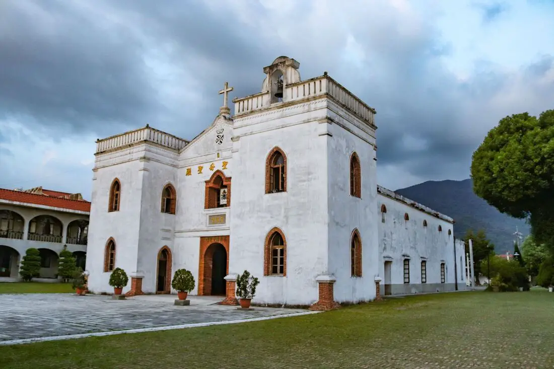
Wanjin Catholic Basilica (aka Wanchin Basilica of the Immaculate Conception) in Wanluan Township of Pingtung dates back to 1861 and was the first Basilica church and the oldest preserved church in Taiwan. It is also the beginning of Wanxing Road, a historic area in the town. Wanjing Night Market also lies on Wanxing Road; it's the most local night market you will ever find in Taiwan.
Background: After the treaty of Tianjin in 1858, the Qing Dynasty allowed Christianity in Taiwan. Catholic Priest Father Fernando Sainz arrived in Kaohsiung in 1859, from the Philippines. At the end of that year, he bought the piece of land where the current church sits for 62 Spanish silver coins. The original church was built with mud brick and completed in 1863 but was damaged in an earthquake in 1865. The church was rebuilt in its current form in 1870 using Spanish Fortress Architecture. Father Fernando Sainz returned to the Philippines in 1869 and died in Manila in 1895. The church underwent further renovations in the mid 1900s. In 1984, the church was named a Basilica by Pope John Paul II, the first church in Taiwan to receive this title. Later an Immaculate Conception Dominican Residence and visitor center were built on the grounds. Hours: 6:30 AM to 9:30 PM Wanjin Night Market: Fridays from 6 Pm to 10 PM Price: Free Tours and Activities in Pingtung: There are many activities available in Pingtung, such as snorkeling, diving, SUPing, surfing, submarine riding, and river tracing. You can find more tours of Kenting on Klook here or KKday here. Where to stay: Looking for a hotel? Find out where to stay in our Taiwan hotels guide or search for the best hotel deals in Taiwan here. We recommend booking through Agoda here, which provides the best quality selection of accommodation in Taiwan. I have stayed at many hostels and hotels in Pingtung, and even almost bought a house here. Some places that I have stayed at and can recommend are Nanwan Kiki (book on Agoda here, Booking.com here), a B&B next to Nanwan Bay, Kenting's most popular Beach. There are also a few decent hotels near Kenting Street Night Market like Kenting Star Inn 888 (book on Agoda here, Klook here, or Booking.com here), or Kenting Dajianshan Hotel (book on Agoda here or Booking.com here). You will notice that none of these hotels are five star resorts (I do not come to Kenting to waste my time at a resort, but you can still search Agoda, Booking.com, or Klook here for those) but they are in my opinion the above have the best value for the money. How to get there: By Car/Scooter: Take Provincial Highway 1 south to the bottom of Taiwan until it becomes Neipu. Then travel east to Wanluan Township until you reach the church. Looking for scooter rental in Pingtung? Click here or here to search for options. If you are looking for car rentals, you can also search Qeeq here, Klook here, or KKday here. You can also check out our car rental guide here. By Bus: You can reach Wanjin Chapel by bus 708, 606, or 8212. You can book tickets to Kaohsiung via high speed rail (HSR) on Klook here or KKDay here, or book tickets via the normal train (TRA) on Klook here. You can book tickets to travel to Pingtung via inter-city bus on Klook here. By Bicycle: Cycling is the best way to enjoy Taiwan's landscapes if you have the time and energy. Looking for bicycle rentals in Taiwan? You can search on KKday here and search for tours on Klook here. You can also check out our Taiwan cycling guide here. Map: Please see below: 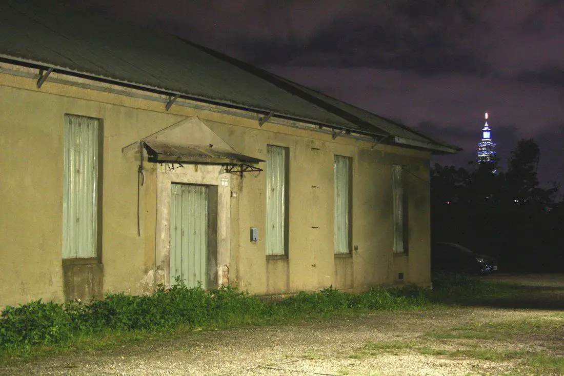
(updated below on 1/15/2019)
A few months ago we wrote a blog about the Songshan Sanatorium Superintendent’s Dormitory, a Japanese-era building that is one of the best preserved in Taipei, which is sitting and rotting while the Taipei government figures out funding for its renovation. We were interested to find the actual sanatorium itself, and if it even still existed. It was not easy to find or easy to get to, but we did eventually find it…at least the part of it that is still standing. I would love to tell everyone where it is, but as it lies on private and protected property; we will not disclose the explicit location. With the help of clues from other blogs and historical photos, we found it abandoned on private property that has 24/7 surveillance. We did not find a single English article on this building, except in statistical research on the hospital facilities at the time. The building itself is not mentioned as a historical building registry of Taipei. History: The original Japanese style, two-story, wooden Sanatorium was constructed in 1915 during the Japanese colonial period of Taiwan. Here is a picture of the original wooden Sanatorium (on the left), and the existing concrete extension: Also, here is a photo of the staff in front of the wooden Sanatorium during the Japanese colonial period. A Japanese Physician was assigned as superintendent, and his dormitory was built nearby (松山療養所所長宿舍), which is now the best preserved and most well-known building connected to the Sanatorium. The Sanatorium’s main purpose was to treat mentally disabled patients, and later was turned into a center to cure tuberculosis. It has had multiple names through the ages, beginning with松山錫口養生院 (Songshan Xikou Health Hospital), and then changed to 松山療養所 (Songshan Sanatorium) in 1925. When the ROC took control, its changed name was changed again to 台灣省立松山療養院, (Taiwan Provincial Songshan Sanatorium) in 1946, with the first superintendent being Yang TianMu (楊添木). It was also known as (or part of it was) 治肺結核療養所 (Tuberculosis Treatment Sanatorium). 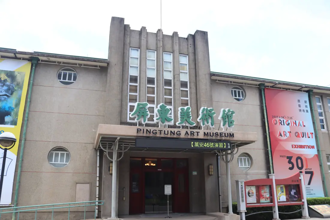
The Pingtung Art Museum is the first municipal art museum established in Taiwan. Here you can enjoy art exhibitions as well as other events. In addition, there is a restored Martial Arts Hall from the Japanese era right next door.
Background: The Pingtung Art Museum was originally the Administrative Office building for Pingtung City, and was completed in 1953. In 2005, the Pingtung City Administrative Building moved to a new location, and the building was used by the Pingtung County Ministry of Culture until it was officially converted into the Pingtung City Art Museum in 2007. In 2012, the art museum was given back to the Pingtung City Administrative Office, meaning that it became the first municipal art museum established in Taiwan. Hours: 9 AM to 5 PM Tuesday to Sunday (closed Mondays) Price: Free Tours and Activities in Pingtung: There are many activities available in Pingtung, such as snorkeling, diving, SUPing, surfing, submarine riding, and river tracing. You can find more tours of Kenting on Klook here or KKday here. Where to stay: Looking for a hotel? Find out where to stay in our Taiwan hotels guide or search for the best hotel deals in Taiwan here. We recommend booking through Agoda here, which provides the best quality selection of accommodation in Taiwan. I have stayed at many hostels and hotels in Pingtung, and even almost bought a house here. Some places that I have stayed at and can recommend are Nanwan Kiki (book on Agoda here, Booking.com here), a B&B next to Nanwan Bay, Kenting's most popular Beach. There are also a few decent hotels near Kenting Street Night Market like Kenting Star Inn 888 (book on Agoda here, Klook here, or Booking.com here), or Kenting Dajianshan Hotel (book on Agoda here or Booking.com here). You will notice that none of these hotels are five star resorts (I do not come to Kenting to waste my time at a resort, but you can still search Agoda, Booking.com, or Klook here for those) but they are in my opinion the above have the best value for the money. How to get there: By Car/Scooter: Take Provincial Highway 1 south to the bottom of Taiwan until it becomes Pingtung City. The Art Museum is on Zhongzheng Road in the middle of the city. Looking for scooter rental in Pingtung? Click here or here to search for options. If you are looking for car rentals, you can also search Qeeq here, Klook here, or KKday here. You can also check out our car rental guide here. By Train: The Art Museum is about a 10 minute walk from Pingtung TRA Station. You can book tickets to Kaohsiung via high speed rail (HSR) on Klook here or KKDay here, or book tickets via the normal train (TRA) on Klook here. You can book tickets to travel to Pingtung via inter-city bus on Klook here. By Bicycle: Cycling is the best way to enjoy Taiwan's landscapes if you have the time and energy. Looking for bicycle rentals in Taiwan? You can search on KKday here and search for tours on Klook here. You can also check out our Taiwan cycling guide here. Map: Please see below: 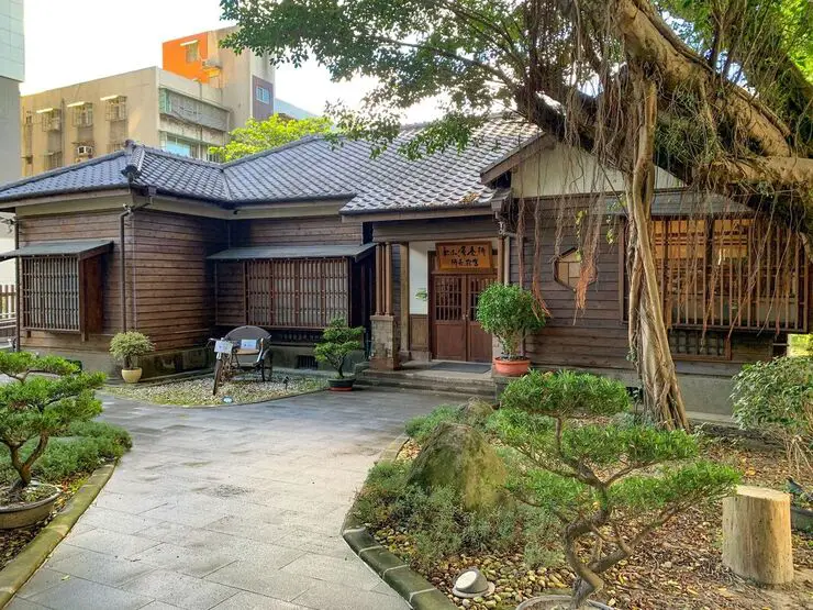
Nangang, the district in Taipei where I live and work, has a rich history that includes being a center for industry and transportation. One such building that lies hidden in Nangang from the Japanese era called “松山療養所長宿舍” which I have translated as “The Songshan Sanatorium Superintendent’s Dormitory.” Now it has been renovated and converted into a coffee shop called "Jingxin Yuan 靜心苑."
When I tell Taiwanese people that I live in Nangang, some older people tell me that it is a place full of factories and industry. However Nangang today is a vibrant and modern part of Taipei, full of greenery and advanced architecture. But sadly, there is almost no trace of Nangang’s industrial history anywhere.
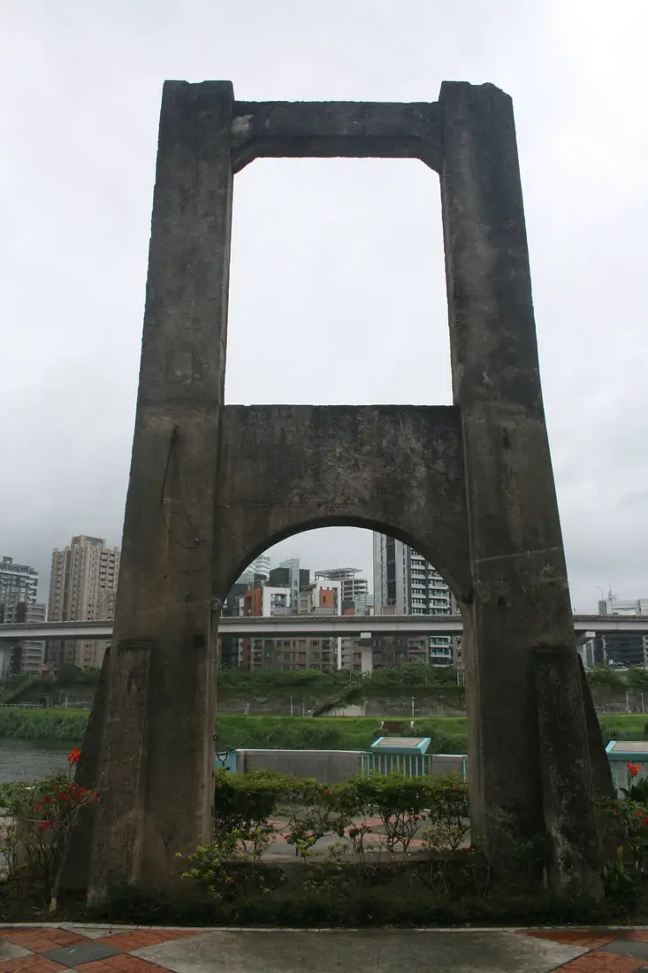
Nangang 南港means “South Port” in Chinese. This south port once rested on the southern banks of the Keelung River near what is now the Neihu MRT depot in Nangang District, Taipei. There was a "North Port" on the Keelung river in what is now Xizhi. Nangang was once part of Neihu District before it split in the ROC era. In the earliest times, Nangang was known as an industry hub for coal, brick making, and tea farming. In order to ship goods from Neihu to Nangang rail station, at least two suspension bridges were made across the Keelung River.
Currently two remaining suspension bridge towers next to the Keelung River from the industrial era of Nangang. The best preserved is “五分吊橋” Wufen suspension bridge. According to the signs next to the bridge, it was built in 1918. |
Author 作家I am an American expat who has extensive experience living, working, and traveling in Taiwan. In my day, I had to learn many things about Taiwan the hard way. But I have come to learn that Taiwan is one of the best places in the world for Foreigners to live. This blog does not represent the opinions of every foreigner in Taiwan. I am just trying to help others learn more about this beautiful country. Tutor ABC - World's No. 1 Online Platform for learning English and Chinese. Get 10% off all Tutor ABC website listed prices with promo code: FOREIGNERS10 Tutor ABC - 世界第一英語和中文線上學習平台 使用促銷代碼: FOREIGNERS10 可享有 Tutor ABC 網站上列出的所有價格 10% 的折扣 Archives 檔案
April 2024
Tutor ABC - World's No. 1 Online Platform for learning English and Chinese. Get 10% off all Tutor ABC website listed prices with promo code: FOREIGNERS10 Tutor ABC - 世界第一英語和中文線上學習平台 使用促銷代碼: FOREIGNERS10 可享有 Tutor ABC 網站上列出的所有價格 10% 的折扣 Categories
|

 RSS Feed