

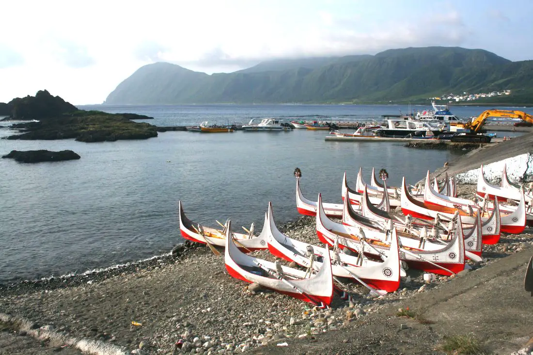
Orchid Island (not to be confused with the Fijian Island of the same name), known in the local Tao language as Ponso No Tao (Island of the people), and in Chinese as Lanyu (蘭嶼) is a secret indigenous people's paradise off the southeastern coast of Taiwan. It is different than any other place in Taiwan, and has the best preserved indigenous culture anywhere in the country. If Taiwan's best tourist activity is experiencing the culture of Taiwan's indigenous peoples, then Lanyu has the best tourist experience anywhere in Taiwan.
Background: History: Orchid Island became inhabited about 800 years ago by the Tao indigenous people (達悟族) (aka Yami people 雅美族, which is a name coined by the Japanese, but the native people prefer Tao), which are thought to have traveled from the Batanes Islands in the Philippines, which are a little less than 200 KM away, cut off by the Bashi Channel. However, Orchid Island is very different than the Philippines. Beginning in1644, some Dutch Sailors were sent to investigate the island, and some settled there among the natives. Because of this, the Island was known as Red Head Island (紅頭嶼) by the Chinese and the Japanese. After the Dutch were defeated in Taiwan, Lanyu was claimed but not controlled by the Qing Dynasty. The Japanese claimed the Island shortly after the Sino-Japanese War in 1895, but protected it as an "ethnological research site" and forbid outsiders from entering. After the Republic of China took over Taiwan following the end of WWII, they continued to ban visitors to the island until 1967, after which tourists were allowed to enter and public schools were built there. Christian missionaries began preaching and living on the island starting in the 1950s, and now basically all native people on the island are Christian (mixed with traditional beliefs). However Christianity was introduced much earlier starting with the Dutch in the 1600s although to a lesser extent. In 1982 a nuclear waste storage plant was built on the south side of the Island without the islanders' consent, causing protests from the inhabitants. Also because of this, the Island inhabitants receive free electricity. The island is volcanic in nature, with the last major eruption being over 5 million years ago. The highest mountain is 552 meters (1,811 feet). Currently there are 2,400 people permanently living on the island, 90% of them being of native Tao descent. Tao Culture: The Tao people number about 2,000 living on Orchid Island, with about another 2,000 living on the Taiwan mainland. The Tao people rely on the sea for survival, and much of their traditions and lifestyle are centered on fishing. The Tao people are mostly Christian but also still practice many of their traditional beliefs. However their ancestral religion included a pantheon of Gods. Traditional roles for men are fishing while roles for women include harvesting taro and sweet potato and weaving. The men usually fish at night or early morning and rest on traditional wooden platforms during the day. Boats are made from planks of wood and are painted red, white, and black. The boat usually has human figures, waves, and the traditional sun image (red and black circles and sun rays) which is said to warn off evil spirits. Boats are considered sacred and the ultimate human creation. There is also a launching ceremony for new boats in which traditional clothes and headgear (such as silver helmets for men and wooden hats for women) are worn, pigs are slaughtered, and the boat is lifted into the air multiple times before being set in the water. Traditional clothes include loin cloths and vests for men, and aprons and vests for women. Young people on the street usually do not wear traditional dress. Flying Fish Festival: There are three basic seasons on Lanyu: one is the flying fish season when flying fish can be easily caught and used and lasts from February to May. The other seasons are from May to October and October to February, when flying fish cannot be caught for ceremonial use. There are many taboos during flying fish season which are discussed below. The Flying Fish Festival lasts from aboutMarch to October when flying fish are caught. During this time many ceremonies take place such as for the beginning of the festival, plentiful harvest, etc. During the festival, there are multiple migrations of flying fish species near Lanyu. There are many taboos during this time, especially when it comes to catching and eating flying fish which are the main life source of the Tao people. Weather and Climate: The island has a tropical rainforest climate, with average high temperatures between 20 and 30 degrees year round. The rainy months are in summer, especially due to Typhoons, but the most sunny days are also in summer (expect a lot of sun), and the most rainy days are in winter. Summer is the tourist season, but spring and fall are also popular times to visit. Winters are said to be dreary, cold, and have constant northeastern winds that can stop airplanes and ferries from departing to the island. When to go: The best time to go they say is around May when it is not too hot and there are no northeasterly winds or typhoons which can cancel your transportation to the island. Typhoon season lasts from around June to October. The busy season is during summer break from June to August, during which time it can be hard to book a hostel or airplane ticket. Winter is the less crowded season, but the water will be cold, there will be constant wind (which could cancel transportation), and it will rain more often. Taboos: General Taboos:
How to get there: By Plane: You can book discount air tickets from Taipei to Taitung on KKday here. The only planes to and from Orchid Island come from Taitung. Flight times: As of the time of this blog, there were six flights per day byDaily Air Corporation from about8 AM to 4 PM (Please note their website is only in Chinese). The flight from Taitung to Lanyu takes about 25 minutes. Please note that the aircraft are small and flights can be cancelled due to high winds or unfavorable weather. Costs: NT 1428 to Lanyu and NT 1360 from Lanyu. You can purchase plane tickets through a tour agency such as Klook or a similar website. By Boat: There are two places that offer ferry rides to Lanyu: Houbihu Harbor (恆春後壁湖漁港) in Pingtung and Fugang Harbor in Taitung (臺東富岡漁港). There are also two ferry companies that operate at both harbors. Both companies leave from both harbors at the same time and arrive at the same time for the same price (2300 NT per person round trip/1150 NT per single trip). Ferry Boat costs: 2300 NT per person round trip (1150 NT per single trip)from both Taitung and Pingtung. Both ferry companies have the same price. Ferry Boat Times: 7:30/7:00 AM departure, 9:30 AM arrival to Lanyu. 12:00/12:30 PM departure, 3:00 PM arrival to Lanyu. 9:30 AM departure from Lanyu, 11:30 arrival to Taitung or Pingtung. 3:00 PM departure from Lanyu, 5:00 PM arrival to Taitung or Pingtung. Both ferry companies depart and arrive at the same time to both locations. You can purchase ferryboat tickets for a discount on Klook here or KKday here. Getting around the island: Rent a scooter! The island is small so you should not need to rent a car. You can rent bicycles but you will not be able to travel as fast. You can also hire a driver to take you on tours. Ask your hostel for more rental information. They can help you book a rental in advance. Tours: You can book multiple tours and activities such as a Tribal Tour, Underground House Tour, day hiking, night hiking, snorkeling, scuba Diving, SUPing / Paddle Boarding, and Freediving. You can search for more tours through Klook here or KKday here. Scooter Rental: Price: expect 500 NT per day. You can book a scooter through Klook here or KKday here. Be sure to book your rental in advance, especially during summer weekends. Ask for help from your hostel owner if needed. I am 100% percent certain you do not need a Taiwan local license to rent scooters here, however they may ask for an international license (but I'm fairly sure they will let you rent without one). Helmet wearing is not enforced at all as you will quickly find, but it's still the law. Also be careful to not hit any goats because they wander as they please. There is only one gas station next to Kaiyuan Fishing Harbor. Car Rental: Price: expect 2000 NT per day. You can rent a car for Lanyu on KKday here. Bicycle Rental: Price: Bike rental is about 400 NT per day. You can rent a bike for Lanyu on KKday here. Accommodation: Booking accommodation on the island can be difficult in summer months and on weekends, when rooms can be fully booked for months in advance. There is a nice selection of rooms on Agoda. Here is a list of every registered hostel on the island, but it is in Chinese. My hostel required that I pay for my room in advance via bank wire transfer (this may not be an option if you are a foreign traveler, so make sure they accept credit cards if you do not have a Taiwan bank account). Expect to pay 2000 - 4000 NT per night for a standard double room on Lanyu. You can also book Wifi and SIM cards for Taiwan on Gigago here. Just to let you know, if you book using the links above, we get some commission at no cost to you, and you can help support our blog. You can click here to receive $5 USD on your first Klook purchase. Map: Please see below:
3 Comments
Maolin District of Kaohsiung City is an amazing outdoor paradise and my favorite place in Taiwan. In this mountainous district of Kaohsiung, you can find waterfalls, streams, hot springs, butterflies, aboriginal culture, and great views, all by the roadside! Popular activities include swimming, hot spring bathing, river tracing, camping, and hiking.
Please note I have also finished blogs about Maolin Village, Wanshan Village, Duona Suspension Bridge, and Duona Village (click the links to see each individual blog). Background: During the Japanese occupation, some of the original inhabitants of Maolin Village live in the mountains behind Wanshan Village. However later these aboriginals were forcibly moved to the current village. Many of the inhabitants were originally located elsewhere, but had to relocate their home or village due to typhoons or unsafe terrain. There are a few abandoned villages above the current village that you can still hike to. The villages have about 2000 total inhabitants, mostly aboriginals from the Rukai (魯凱族) Wulu Bunun (布農) and Paiwan (排灣) tribes, as well as some Han Chinese people. The district also has Maolin Middle school, the only middle school, and three elementary schools. Wanshan has the smallest population of any village in Taiwan according to the government website here, with a population of just 450 people. 95% of the people are aborigines from the Rukai Tribe (魯凱族), and the rest are either from the Wulu Bunun Tribe (布農) or Han Chinese. Originally the people of Wanshan village lived at the base of Mali Mountain (麻里山), but were moved by the government in 1956 to their current location. Many of the inhabitants of Maolin were originally located elsewhere, but had to relocate their home or village due to typhoons or unsafe terrain. There are a few abandoned villages around Maolin that you can still hike to. Typhoon Morakot brought record floods to Taiwan because it slowly moved over the island delivering torrential rain. Nearly 700 people were killed during the disaster (to see what Maolin looked like right after the flooding, check out this blog here). Basically all the bridges in Maolin were destroyed during Typhoon Morakot in 2009 except Duona Suspension bridge which is built so high that it would never be affected by floodwater. Most all the bridges currently in Maolin were reconstructed after the 2009 floods. Duona is the most remote village in Maolin District of Kaohsiung City, and is said to harbor the most complete version of the Rukai Aborigine culture. The Rukai People first began to move into the area now known as Duona about 300 years ago (1700s), making it one of the oldest aborigine villages in Taiwan. Most of the people live in traditional stone houses made from nearby plentiful shale rock, which are characteristic of the Rukai Tribe. The stone houses are warm in the winter and stay cool during the summer. Near the village is a small plain which is said to be the home of Taiwan's indigenous species of black rice. The village was almost completely cut off from the outside world until the Japanese built the Duona Suspension Bridge, which helped to link it to the rest of Taiwan as well as better control the native population. The actual Distrcit boundaries extend to Pingtung County and Taitung County, and include largely untouched and "virgin" forests and mountain wilderness areas such as Shuang-guei Lake, providing precious wildlife habitat for many of Taiwan's indigenous animals and plants. Price: Free Hours: 24/7 When to go: I recommend going in the summer time when the waterfalls have plenty of water and warm temperatures make it a great time to go swimming. In winter it will be cold and the waterfalls can dry up. On the other hand if you want to go just for hiking, winter would be a better time to go. If there is a Typhoon, the inhabitants of Maolin will be evacuated, and you should not try to go in for your own safety. If you are coming to see butterflies, the butterfly migration is in the fall and ends roughly in November. How to get there: By Car: Maolin can be reached via provincial highway 27 from Pingtung or Liugui. Once you come to Dajin Bridge, go straight up the mountain. Looking for scooter rental in Kaohsiung? You can check out Klook here or KKday here to search for options. You can check also out our scooter rental guide here. If you are looking for car rentals, you can search Qeeq here, KKday here, or Klook here. You can also check out our car rental guide here. By Bus: You can take a bus there but I don't recommend it. It's a 3 hour bus ride from Pingtung Bus Station. If you can rent a car or scooter it is about a 1 1/2 hour drive from Kaohsiung. You can book tickets to travel to Kaohsiung via inter-city bus on Klook here. You can book tickets to Kaohsiung via high speed rail (HSR) on Klook here or KKDay here. Book tickets via the normal train (TRA) on Klook here. You can also book a Kaohsiung Travel pass here. Accommodation We have stayed at and recommend Chao She Hotel (you can book on Agoda here, Booking.com here, Hotels.com here, or Expedia here) IHI Sanduo Travel Hotel (you can book on Agoda here, Booking.com here, Hotels.com here, or Expedia here), and Mingli Hotel (you can book on Agoda here, Klook here, or Hotels.com here) which are three inexpensive and high quality choices in downtown Kaohsiung. I also have stayed at and recommend Kaohsiung Meinong Rabbit Paul Homestay B&B (you can book on Agoda here, Booking.com here, or Trip.com here), a quiet B&B in rural Meinong, and Chengching Lakeside Resort (you can book on Agoda here, Booking.com or Trip.com here)and the Grand Hotel Kaohsiung (you can book on Agoda here, Booking.com here, Hotels.com here, or Expedia here) which both offer breakfast buffet and free entrance into Chenqing Lake Park. I have also stayed at the 85 sky tower which offers great views of the city; you can search for rooms in the 85 sky tower on Agoda here, Booking.com here, Hotels.com here, Expedia here, or Trip.com here). Find out more about where to stay in our Taiwan hotels guide or search for the best hotel deals in Taiwan here. We recommend booking through Agoda here, which provides the best quality selection of accommodation on the islands. You can also book Wifi and SIM cards for Taiwan on Gigago here. Need travel insurance? Compare prices on Insubuy here. Tours: You can find more tours and activities in Kaohsiung such as Pier 2, Meinong Hakka Museum, Hamasen Railway Museum, Suzuka Circuit Park, i-Ride Kaohsiung Visual 5D Flying Theater, National Science and Technology Museum , Senya Village Restaruant, Austin Land, Ski School Indoor Ski Slope, and many more on Klook here or KKday here. Just to let you know, if you book using the links above, we get some commission at no cost to you, and you can help support our blog. You can click here to receive $5 USD on your first Klook purchase. Map: Please see a map below marked with all the destinations we will visit in this blog: 
Taitung has some of the most beautiful scenery in Taiwan, two amazing offshore islands, a striking coastline, deep mountains, and most of all it is bursting with unique aboriginal culture, with indigenous people making up over one-third of the population. It is an unmissable stop on your next trip to Taiwan. Here we have compiled our full guide to Taitung County.
Historical Background: Taitung has been inhabited by the Amis Aboriginal Tribe which has lived there since at least 1500 BC, and over 35% of the people that live there are Taiwan Aborigines. The area is still a center for Amis rituals and traditional ceremonies, as well as aboriginal culture. The east rift valley was also settled by aboriginal tribes such as the Puyuma which relocated from Pingtung. Qing dynasty Chinese farmers started settling there in 1875, as a reaction to the Mudan Incident of 1871 (in which a crew of shipwrecked Japanese sailors were beheaded by Taiwan aborigines) and the Japanese punitive expedition to Taiwan in 1874. After the Japanese took control of Taiwan, Taitung's main industries were growing sugar cane and rice. The eastern railway line was completed in 1926, linking Taitung to the rest of Taiwan. After the ROC took control of Taiwan, Taitung Airport opened in 1981, which further improved transportation links to the region, however, Taitung has remained relatively undeveloped when compared to the rest of Taiwan, and the population of about 200,000 has been in decline for years. However Taitung has become an important tourist destination, and the local government has invested heavily in tourism development. With its untamed and undeveloped landscape, towering mountains, beautiful coastline, and vibrant aboriginal culture, Taitung has become a tourist hot spot in Taiwan. When to go: The best time to go they say is around May when it is not too hot and there are no northeasterly winds or typhoons which can cancel your transportation to the island. The typhoon season lasts from around June to October. The busy season is during summer break from June to August, during which time it can be hard to book a hostel or airplane ticket. Winter is the less crowded season, but the water will be colder, there will be constant wind (which could cancel transportation), and it will rain more often. How to get there: By Plane: Traveling to Taitung by plane is the fastest way to get there. The trip only takes one hour from Taipei, and there are planes that leave daily through Mandarin Airlines and Uni Air. From Taitung, where you can switch to Saily Air which will take you the rest of the way to Green Island or Orchid Island. A plane ticket to Taitung takes about one hour and costs about 5000 NT per round trip. You can book discount tickets to Taitung on KKday here. You can also book cheap flights to Kinmen on Trip.com or CheapO Air. You can also search for cheap flights in Taiwan here. By Train: The train ride from Taipei to Taitung takes 3-4 hours and costs about 800 NT one way. Book tickets via the normal train (TRA) on Klook here. By Car/Scooter: From Taipei, a car ride to Taitung takes about six hours, and a scooter ride takes about eight hours. You can rent a scooter from Taitung Station on Klook or KKday. Scooter rental is about 300 NT per day. You can check out our scooter rental guide here. How to get around: Rent a scooter! Unless you are travelling with small children or elderly people you should not need to rent a car. You can rent bicycles but you will not be able to travel as fast. You can also hire a driver to take you on tours. By scooter: You can rent a scooter from Taitung Station on Klook or KKday. Scooter rental is about 300 NT per day. You can check out our scooter rental guide here. By car / taxi: You can also rent a car for about 1500 NT per day. You can rent a car on Qeeq here or Klook here. You can hire a driver or tax; you can charter a car here. You can check out our car rental guide here. By Bicycle: Cycling is the best way to enjoy Taiwan's landscapes if you have the time and energy. Looking for bicycle rentals in Taiwan? You can search on KKday here and search for tours on Klook here. You can also check out our Taiwan cycling guide here. Accommodation: Booking accommodation in the Taitung can be difficult in the summer months and on weekends. We suggest a better quality selection on Agoda.com. We have stayed at and recommend the Papago International Resort in Chishang (you can book on Agoda here, Booking.com here, Hotels.com here, or Expedia here), which is a five star hotel with private villas with pools for each room, and Mountain and Ocean B & B in Taimali (you can book on Agoda here, Booking.com here, Hotels.com here, or Expedia here), which is a quiet and affordable B&B right next to the beach. You can also find out where to stay in our Taiwan hotels guide or search for the best hotels in Taiwan here. You can also book Wifi and SIM cards for Taiwan on Gigago here. Need travel insurance? Compare prices on Insubuy here. Tours: There are many companies offering snorkeling, diving, SUPing, Surfing, Speed Boating, Glamping, River tracing, and other tours in Taitung. You can find more tours of Taitung on Klook here or KKday here. Just to let you know, if you book using the links above, we get some commission at no cost to you, and you can help support our blog. You can click here to receive $5 USD on your first Klook purchase. Map: See a map of the places we will cover in this blog below: 
Nantou lies at the heart of Taiwan and is it's only landlocked county. It is known for its rugged natural landscapes and mountains, and includes the highest mountain in East Asia. If you come to Taiwan you should definitely pass through this place and stop by at some of the sights we will mention below.
How to get around Nantou: As always, we recommend renting a scooter as the best way to see Taiwan. However, you can also a great deal of Miaoli by taking the train to Taichung then switching to inter-city bus, or local bus. Getting around in a car is also a convenient option as there is plenty of parking pretty much everywhere in this less crowded county. Scooter Rental: Looking for scooter rental in Nantou? Search Klook here or KKday here to search for options. You can also check out our scooter rental guide here. Car Rental: If you are looking for car rentals, you can also search Qeeq here, Klook here, KKday here. You can also check out our car rental guide here. By Bus: You can book tickets to travel to Nantou via inter-city bus on Klook here. You can book tickets to Taichung via high speed rail (HSR) on Klook here or KKDay here, or book tickets via the normal train (TRA) on Klook here, then switch to a bus to Nantou. Bicycle Rental: Cycling is the best way to enjoy Taiwan's landscapes if you have the time and energy. Looking for bicycle rentals in Taiwan? You can search on KKday here and search for tours on Klook here. You can also check out our Taiwan cycling guide here. Just to let you know, if you book using the links above, we get some commission at no cost to you, and you can help support our blog. You can click here to receive $5 USD on your first Klook purchase. Tours: There are many tours and activities available in Nantou such as river Tracing, paragliding, Shanlinxi Forest Recreation Area 杉林溪, Cona's Chocolate Castle, Shuiyuan Suspension Bridge, JOJOZOO Park, and Aowanda Forest Recreation Area. You can find more tours of Nantou on Klook here or KKday here. Accommodation: We have stayed at and recommend Jenq Yang Hotspring Hotel (you can book on Agoda here, Booking.com here, Trip.com here, or Klook here), a hot spring hotel near the mystical Lushan hot spring, and Maple Leaf Holiday Villa (you can book on Agoda here, Booking.com here, Hotels.com here, Expedia.com here, Trip.com here, or Klook here), a lodge with a great view and within walking distance of Cingjing Farm. I also have stayed at and recommend Kirin Villa (you can book on Agoda here or Booking.com here), a mountain resort in Puli near Sun Moon Lake. Looking for a hotel? Find out where to stay in our Taiwan hotels guide or search for the best hotel deals in Taiwan here. We recommend booking through Agoda here, which provides the best quality selection of accommodation on the islands. You can also book Wifi and SIM cards for Taiwan on Gigago here. Map: Below is a map of these sites: 
Jiaobanshan is a scenic area in the mountainous Fuxing District of Taoyuan. Here you can enjoy majestic views of Xikou Suspension Bridge and the Dahan River. You can also enjoy a local shopping area and the aboriginal culture of the area nearby.
Brief Historical Background: Fuxing District is the largest district in Taoyuan City, and also the least populous (13,000) and is home to the Ayatal aboriginal tribe who have inhabited the area for centuries. They named the area Pyasan, meaning a trading post. The area was named Jiaobanshan during the Qing Dynasty by Liu Mingchuan because the area resembled triangular shapes, shaped by the Dahan River. In 1954, the area was renamed Fuxing (meaning rejuvenation) District by Chiang Kai-shek as a token of the rejuvenation of the nation. The area is known for its aboriginal culture and as a recreational mountain area, especially for such places as Xiaowulai and Lalashan. Hours: 24/7 Price: Free Where to stay: Looking for a hotel in Taoyuan? We recommend the Novotel Taipei Taoyuan International Airport which has great service and is conveniently located right next to Taoyuan Airport, the MRT, and HSR station (you can book on Agoda here or Booking.com here). We also recommend the Fullon Hotel Taoyuan which also has great service and is located in downtown Taoyuan City (you can book on Agoda here or Booking.com here). Looking for a hotel? We recommend booking through Booking.com here, which provides the best quality selection of accommodation in Taiwan. Find out where to stay in our Taiwan hotels guide or search for the best hotel deals in Taiwan here. Activities in Taoyuan: Ice Skating, Rock Climbing, Mountain Climbing, Cycling, High Ropes, Ziplining, Archery, Vietnamese BBQ, Batting Cages, Glamping, Van Camping, Photo Shoot, Turkish Mosaic DIY, Thai Massage, Painting, Baking, Go Karting, Imax Theater, Japanese Style Buffet, Tourist Factory Experience, peach and fruit picking, Ring-making DIY, handmade popsicle DIY, and more on on Tripadvisor here, Klook here, or KKday here. How to get there: By Car: Take Provincial Highway 7 east up Fuxing District until you get near Jiaobanshan and turn right onto Ren'ai Road. There is limited parking nearby. If you are looking for car rentals, you can also search Qeeq here, Klook here, or KKday here. By Scooter: Take Provincial Highway 7 east up Fuxing District until you get near Jiaobanshan and turn right onto Ren'ai Road. There is limited parking nearby. Looking for scooter rental in Taoyuan? Search Klook here or KKday here to look for options. By Bus: You can take many different busses to Taoyuan Bus Fuxing Station. You can book tickets to travel to Taoyuan via inter-city bus on Klook here. Book tickets via the normal train (TRA) on Klook here. By Bicycle: Cycling is the best way to enjoy Taiwan's landscapes if you have the time and energy. Looking for bicycle rentals in Taiwan? You can use Taiwan's many Youbike sharing stations, or search for rentals on KKday here, and search for tours on Klook here. You can also check out our Taiwan cycling guide here. You can also book a cycling tour on TripAdvisor here. For more information, check out our Taiwan transportation guide here. Map: Check out the map below: 
Shimen Ancient Battlefield (aka Shimen Historic Battlefield Macacukes 石門古戰場) in Mudan Township of Pingtung is where local Paiwan indigenous people fought a Japanese invading force in the aftermath of the Mudan Incident. Here the Paiwan people were able to stall the Japanese advance but were ultimately defeated and agreed to stop attacking shipwrecked ships. This spot along the river played an important part in Taiwan's history and is also important for the local Paiwan people who still live there. Now you can enjoy the natural scenery, historical markers, and hiking trails nearby.
Background: In 1871, a ship from the Ryukyuan Kingdom was shipwrecked near Mudan Village, and 54 Ryukyu men were massacred by the local Paiwan aboriginals. Even though the Ryukyuan kingdom was independent, it asked for help from the Qing Dynasty, its main trading partner, to pacify the Taiwanese aboriginals. Later in 1872, Japan dethroned the King of the Ryukyuan Kingdom and asked that the Qing Dynasty be held responsible for the massacre. The Qing denied having control over that region of Taiwan, so Japan sent soldiers to avenge those massacred as part of the 1874 invasion of Taiwan. A war ensued, and Japan entered Taiwan at Sheliao (near Guishan) on the Hengchun Peninsula and was stopped for a while at Shimen. Shimen literally means stone gate, referring to the narrow canyon that the Sichong River runs through here. The Japanese army was eventually successful at moving past Shimen and burned all nearby Paiwan Villages. The villagers promised to stop attacking shipwrecked sailors and began flying the Japanese flag which they saw as a sign of peace, and which the Japanese saw as a claim of jurisdiction. In the end, 561 Japanese soldiers died from disease while only 12 were killed in battle. 89 Paiwan aboriginals were killed in battle. Japan then negotiated with China with the help of American and British advisors, and China recognized Japanese control of the Ryukyu Islands and made payment to Japan for peacekeeping in the area. The Japanese finally withdrew from Taiwan in December 1875. In the end, the battle helped Japan solidify its influence on Taiwan and the Ryukyu Islands, emboldening it later to take over Taiwan. Hours: 24/7 Price: Free Tours and Activities in Pingtung: There are many activities available in Pingtung, such as snorkeling, diving, SUPing, surfing, submarine riding, and river tracing. You can find more tours of Kenting on Klook here or KKday here. Accommodation: Looking for a hotel? Find out where to stay in our Taiwan hotels guide or search for the best hotel deals in Taiwan here. We recommend booking through Agoda here, which provides the best quality selection of accommodation in Taiwan. I have stayed at many hostels and hotels in Kenting, and even almost bought a house here. Some places that I have stayed at and can recommend are Nanwan Kiki (book on Agoda here, Booking.com here), a B&B next to Nanwan Bay, Kenting's most popular Beach. There are also a few decent hotels near Kenting Street Night Market like Kenting Star Inn 888 (book on Agoda here, Klook here, Hotels.com here, Expedia here, or Booking.com here), or Kenting Dajianshan Hotel (book on Agoda here, Booking.com here, Hotels.com here, or Expedia here). You will notice that none of these hotels are five star resorts (I do not come to Kenting to waste my time at a resort, but you can still search Agoda, Booking.com, Hotels.com, or Expedia for those) but they are in my opinion the above have the best value for the money. How to get there: By Car/Scooter: Take Provincial Highway 1 south to the bottom of Taiwan until it Checheng. Then travel east toward Mudan Township until you reach the Shimen Historic Battlefield memorial marker. Looking for scooter rental in Pingtung? Click here or here to search for options. You can also check out our scooter rental guide here. If you are looking for car rentals, you can also search Qeeq here, Klook here, or KKday here. You can also check out our car rental guide here. By Bus: You can reach Mudan from Pingtung Bus 1773 or 302, but it will take over three hours. You can book tickets to Kaohsiung via high speed rail (HSR) on Klook here or KKDay here, or book tickets via the normal train (TRA) on Klook here. You can book tickets to travel to Pingtung via inter-city bus on Klook here. By Bicycle: Cycling is the best way to enjoy Taiwan's landscapes if you have the time and energy. Looking for bicycle rentals in Taiwan? You can search on KKday here and search for tours on Klook here. You can also check out our Taiwan cycling guide here. Map: Please see below: 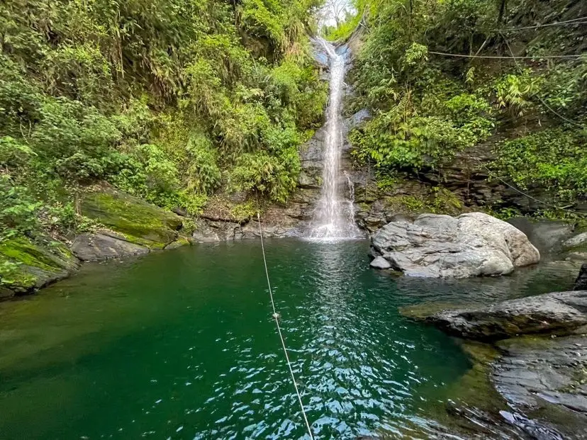
Wutan Waterfall (武潭瀑布) in Taiwu Township of Pingtung County is an easily accessible waterfall that is usually free of people. This area of mountains in southern Taiwan has almost unlimited swimmable waterfalls that are devoid of people. It is definitely a fun trip in the mountains that will not take too much time, and a great place to enjoy nature.
Background: Wutan Waterfall is about 20 meters high and features a large and deep swimming pool. It is named after Taiwu Village, which is an aboriginal village within walking distance down the hill. The holes in the rocks have been carved out of the rocks after thousands of years of erosion. There are stone steps along the side of the waterfall as well as ropes. The waterfall can get busy during holidays and weekends. Hours: 24/7 Price: Free Difficulty: Easy: 20 meters in length (one way) and 10 meters in elevation gain. The whole hike should take about two minutes from the road. Where to stay: Looking for a hotel? Find out where to stay in our Taiwan hotels guide or search for the best hotel deals in Taiwan here. We recommend booking through Agoda here, which provides the best quality selection of accommodation in Taiwan. I have stayed at many hostels and hotels in Pingtung, and even almost bought a house here. Some places that I have stayed at and can recommend are Nanwan Kiki (book on Agoda here, Booking.com here), a B&B next to Nanwan Bay, Kenting's most popular Beach. There are also a few decent hotels near Kenting Street Night Market like Kenting Star Inn 888 (book on Agoda here, Klook here, or Booking.com here), or Kenting Dajianshan Hotel (book on Agoda here or Booking.com here). You will notice that none of these hotels are five star resorts (I do not come to Kenting to waste my time at a resort, but you can still search Agoda, Booking.com, or Klook here for those) but they are in my opinion the above have the best value for the money. Tours: You can go book a river trace in Pingtung on Klook here or KKday here. How to get there: By Car/Scooter: From Pingtung, take Provincial Highway 1 souththeast until you reach Neipu and then turn southeast until you hit the 185. Drive until you reach Taiwu Village and turn up the mountain past the village to the waterfall. The waterfall is easy to find along the side of the road and there is some parking along the side of the road. Looking for scooter rental in Kenting? Click here or here to search for options. You can also check out our Taiwan scooter rental guide here. If you are looking for car rentals, you can also search Qeeq here, Klook here, or KKday here. You can also check out our car rental guide here. By Bus: You can take bus 8212 to Wutan, then it is about a 30 minute walk to the waterfall. You can book tickets to Pingtung via high speed rail (HSR) on Klook here or KKDay here, or book tickets via the normal train (TRA) on Klook here. You can book tickets to travel to Pingtung via inter-city bus on Klook here. By Bicycle: Cycling is the best way to enjoy Taiwan's landscapes if you have the time and energy. Looking for bicycle rentals in Taiwan? You can search on KKday here and search for tours on Klook here. You can also check out our Taiwan cycling guide here. Map: Please see below: 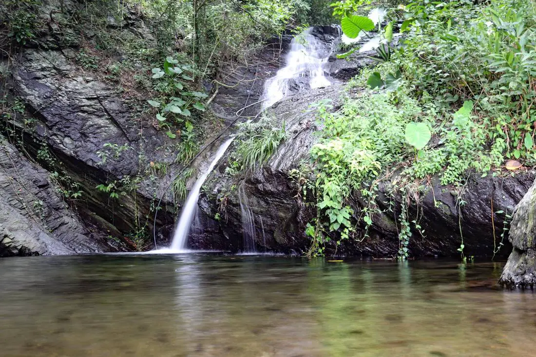
Koushe Waterfall (口社瀑布) near Koushe Village in Gaoshu Township of Pingtung is an easily accessible, swimmable waterfall right next to the side of the road. This area of mountains in southern Taiwan has almost unlimited swimmable waterfalls that are devoid of people. It is definitely a fun trip in the mountains that will not take too much time, and a great place to enjoy nature.
Background: Koushe Waterfall is about 12 meters high and features a large swimming pool. It is named for Koushe Village, which is an aboriginal village within walking distance down the hill. The holes in the rocks have been carved out of the rocks after thousands of years of erosion, and there is a rope climb and trail along the side of the waterfalls, which can be climbed in just a few minutes. Hours: 24/7 Price: Free Difficulty: Easy: 20 meters in length (one way) and 10 meters in elevation gain. The whole hike should take about two minutes from the road. Accommodation: Looking for a hotel? Find out where to stay in our Taiwan hotels guide or search for the best hotel deals in Taiwan here. We recommend booking through Agoda here, which provides the best quality selection of accommodation in Taiwan. I have stayed at many hostels and hotels in Pingtung, and even almost bought a house here. Some places that I have stayed at and can recommend are Nanwan Kiki (book on Agoda here, Booking.com here), a B&B next to Nanwan Bay, Kenting's most popular Beach. There are also a few decent hotels near Kenting Street Night Market like Kenting Star Inn 888 (book on Agoda here, Klook here, Hotels.com here, Expedia here, or Booking.com here), or Kenting Dajianshan Hotel (book on Agoda here, Booking.com here, Hotels.com here, or Expedia here). You will notice that none of these hotels are five star resorts (I do not come to Pingtung to waste my time at a resort, but you can still search Agoda, Booking.com, Hotels.com, or Expedia for those) but they are in my opinion the above have the best value for the money. Tours: You can go book a river trace in Pingtung on Klook here or KKday here. How to get there: By Car/Scooter: From Pingtung, take Provincial Highway 27 northeast until you reach Gaoshu and then turn southeast until you hit the 185. Drive until you reach Koushe Village and turn up the mountain just before the village. The waterfall is easy to find along the side of the road. Looking for scooter rental in Kenting? Click here or here to search for options. You can also check out our Taiwan scooter rental guide here. If you are looking for car rentals, you can also search here. You can also check out our car rental guide here. By Bus: There is no public transportation to this area. Consider taking a taxi or renting a vehicle. You can book tickets to Pingtung via high speed rail (HSR) on Klook here or KKDay here, or book tickets via the normal train (TRA) on Klook here. You can book tickets to travel to Pingtung via inter-city bus on Klook here. By Bicycle: Cycling is the best way to enjoy Taiwan's landscapes if you have the time and energy. Looking for bicycle rentals in Taiwan? You can search on KKday here and search for tours on Klook here. You can also check out our Taiwan cycling guide here. Map: Please see below: 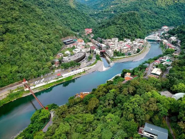
Wulai has become a major tourist attraction, partly because of its close proximity to Taipei. It has museums, waterfalls, a gondola, a train, an old street night market, and most of all hot springs. It has an old Japanese era coal mining railroad track which has been restored with a working train. In addition there are hikes, wildlife, and endless mountain scenery to explore.
Background: Wulai was originally an Atayal aborigine village, its name meaning hot and poisonous. There has always been natural hot springs in Wulai, but much of that water has been channeled into hotels and public bathhouses. The free hot springs stood at the bottom of the hill next to the river, and was a collection of used hot spring water from the hotels and paid hot springs above. In its prime, it boasted the largest free outdoor hot springs in Taiwan. Recently the District of Wulai in New Taipei has become a major tourist attraction, partly because of its close proximity to Taipei. It has museums, waterfalls, a gondola, a train, an old street night market, and most of all hot springs. The main delicacies on the old street are Taiwan ingenuous foods such as wild boar meat and rice steamed in bamboo. Hours: Wulai Old Street: Roughly 10 AM to 8 PM Cable Car and Yun Hsien Amusement Park Entrance: 9 AM to 4:30 PM You can book tickets to the gondola and to Yun Hsien theme park on Klook here or KKday here. Neidong Waterfall: 8 AM to 5 PM. You can book tickets to Neidong Forest Recreation Area on KKday here or Klook here. Price: Wulai Old Street: Free Cable Car and Yun Hsien Amusement Park Entrance: 220 NT per person You can book tickets to the gondola and to Yun Hsien theme park on Klook here or KKday here. Neidong Waterfall: 65 NT per person. You can book tickets on KKday here or Klook here. Hot Spring Bath: 300-500 NT. You can look for hot spring bath experiences on Klook here or KKday here. Delicacies: Wilde Boar meat, hot spring eggs, rice steamed in bamboo, among others. Hotels in Wulai: There are many hot spring hotels in Wulai that have a hot spring tub right in the room. We have stayed at and recommend Wulai SungLyu Hot Spring Resort, which is a hot spring resort with great views just above Wulai Old Street. You can book on Booking.com here, Agoda here, Hotels.com here, TripAdvisor here, Trip.com here, Klook here, Kayak here, or Expedia here. Looking for a hotel? We recommend booking through Booking.com here, which provides the best quality selection of accommodation in Taiwan. Find out where to stay in our Taiwan hotels guide or search for the best hotel deals in Taiwan here. How to get there: By Bus: From central Taipei, take bus 849 to Wulai Old Street. The trips takes about an hour and a half. You can purchase a discount easy card to use on a bus to Wulai on Klook here or KKday here. You can also book a Taipei travel pass on Klook here. By Car/Scooter: From Taipei, take provincial highway 9甲 to Wulai. There is a large paid parking garage in front of the old street. You may also be able to find free parking up the mountain. If you are looking for car rentals, you can also search Qeeq here, Klook here, or KKday here. You can also check out our car rental guide here. Looking for scooter rental in Taipei? You can search on Klook here or KKday here to search for options. You can also check out our scooter rental guide here. By Taxi: You can take short rides for about 150 NT, or hire a Taxi for a day for around 150 USD on Klook here. By Bicycle: Cycling is the best way to enjoy Taiwan's landscapes if you have the time and energy. Looking for bicycle rentals in Taiwan? You can use Taiwan's many Youbike sharing stations, or search for rentals on KKday here, and search for tours on Klook here. You can also check out our Taiwan cycling guide here. You can also book a Sunset Riverside Bike Ride and Historical Tour, 4 Hour Cycling in Taipei, Ultimate 8-Hour Cycling City Tour, or Taipei City Bike Tour with Night Market Experience on TripAdvisor here. For more information, check out our Taiwan transportation guide here. Map: Please see below of the places covered in this blog: 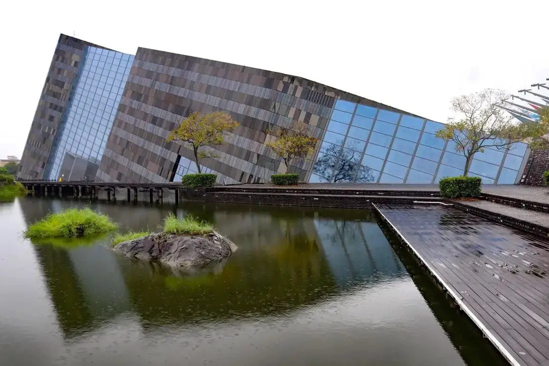
The Lanyang Museum focuses on Toucheng's history and artifacts. If you want to learn about the history of Toucheng, this is the place to visit. It is also a beautiful building, designed in the shape of Cuestas, or slanted rocks that appear commonly along Toucheng's coastline.
Background: Before Chinese settlers came, the area around Toucheng was inhabited by the Ketagalan Aboriginal tribe, whose language is now extinct. The name Toucheng literally means "first town" in Chinese, because it was the first settlement in Yilan, settled in the late 1700s. With the nearby Wushih and Touwei Harbors around the same time, it became the economic focal point of Yilan. However in the late 1800s and early 1900s Wushih Harbor and Touwei Harbor silted in, reducing their function. With the advent of the Japanese built Yilan railway line in the mid-1900's, as well as constant floods and continually silting of the harbors, Toucheng quickly lost its importance economically and fell into decay. After residents of Turtle Island were relocated to Daxi in Toucheng, Daxi Harbor was expanded and has become one of the largest fishing harbors in the area. Due to its close proximity to Taipei, Toucheng has become a major tourist area and may be the most popular surfing location in Taiwan. Price: 100 NT You can book discount exhibition tickets to the museum on KKday here or book a tour through Klook here. Hours: 9 AM to 5 PM every day except Wednesdays. Tours and Activities: You can purchase tours and tickets for many activities in Yilan such as Su'ao Crayon Castle, Taipingshan, Turtle Island, Lanyang Museum, Toucheng Leisure Farm, Zhang Mei Ama Capybura Farm, Bambi Land, Yinong Ranch, National Center for Traditional Arts, Taxi Museum, Glamping, Camping, ATV / 4-wheeling experience, SUP / paddle boarding, Ximeng Forest Theater, Surfing, Kayaking, Horse Riding, River Tracing, River Rafting, River Tubing, Pack Rafting, Water Biking, Snorkeling, Canoeing, Shrimping and many others through Klook here or KKday here. Accommodation: We have stayed at and recommend Toucheng Leisure Farm. You can also book a room there on Klook here, Agoda here, Booking.com here, Hotels.com here, Expedia here, or Trip.com here. Looking for a hotel? We recommend booking through Agoda here, which provides the best quality selection of accommodation in Taiwan. Find out where to stay in our Taiwan hotels guide or search for the best hotel deals in Taiwan here. How to get there: By TRA: Take the TRA to any of the stations in Toucheng. You can book tickets to travel to Yilan via inter-city bus on Klook here. You can book tickets to Yialn via high speed rail (HSR) on Klook here or KKDay here. Book tickets via the normal train (TRA) on Klook here. Bicycle rental: Cycling is the best way to enjoy Taiwan's landscapes if you have the time and energy. Looking for bicycle rentals in Taiwan? You can search on KKday here and search for tours on Klook here. You can also check out our Taiwan cycling guide here. By Car: From Taipei, take National Freeway 5 to Toucheng. Be careful to note that on Sundays there are highway controls for cars travelling from Yilan to Taipei from 3 PM to 8 PM, so avoid travelling back to Taipei at that time to beat the traffic. Looking for scooter rental in Yilan? You can search Klook here or KKday here to look for options. You can also check out our scooter rental guide here. If you are looking for car rentals in Yilan, you can also search Klook here or KKDay here. You can also check out our car rental guide here. Map: 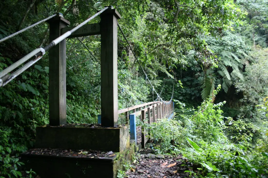
Nanao Old Trail (aka Nanao Historic Trail or Nanao Old Raod) is a historic hiking trail in Yilan County, Taiwan. It was once a major route for the Ayatal aboriginal tribe, and was improved by during the Japanese colonial era. Now you can hike only a small section of the original trail, but you can still see beautiful mountainous scenes, rivers, and wildlife, as well as appreciate the history here.
Background: Nanao Old trail was an important trail built by the Ayatal Indigenous Tribe in Taiwan to connect villages in the mountains of Yilan. In 1874, the Qing Dynasty blasted a road through Ayatal lands from Yilan to Hualien, but after a few years they were unable to maintain it due to constant attacks from the Ayatal tribesmen. Therefore the road was soon abandoned. During the Japaneses era in the early 1900s, the Japanese pacified the local people, and improved the Nanao Old Trail and set up police stations and checkpoints along the road to better control the native population and obtain resources in the area. The road stretched 27.5KM from Nanao to Datong Township. After the ROC took control of Taiwan, the trail was opened for recreational purposes. In 2012, most of the trail was closed due to damage from Typhoon Saola (蘇拉), and has never been fully repaired. Now only 3 kilometers of the original trail remain open to the public. Hours: 24/7 Price: Free Length: 3KM one way, about 3 hours Tours and Activities: You can purchase tours and tickets for many activities in Yilan such as Su'ao Crayon Castle, Taipingshan, Turtle Island, Lanyang Museum, Toucheng Leisure Farm, Zhang Mei Ama Capybura Farm, Bambi Land, Yinong Ranch, National Center for Traditional Arts, Taxi Museum, Glamping, Camping, ATV / 4-wheeling experience, SUP / paddle boarding, Ximeng Forest Theater, Surfing, Kayaking, Horse Riding, River Tracing, River Rafting, River Tubing, Pack Rafting, Water Biking, Snorkeling, Canoeing, Shrimping and many others through Klook here or KKday here. Accommodation: Looking for a hotel? We recommend booking through Agoda here, which provides the best quality selection of accommodation on the islands. We have stayed at and recommend Ying Shih Guest House, a resort in Datong Township near Taipingshan and Fan Fan Hot Spring (you can book on Agoda here or Booking.com here), and Jiaosi Hotspring Hotel, a hotel with hot springs in each room (you can book on Agoda here, Booking.com here, Hotels.com here, Expedia here, or Trip.com here). We have also stayed at Toucheng Leisure Farm, a recreational farm and experience center in Toucheng (you can book on Agoda here, Booking.com here, Hotels.com here, Expedia here, on Klook here, or on Trip.com here). You can also book Wifi and SIM cards for Taiwan on Gigago here. Need travel insurance? Compare prices on Insubuy here. Just to let you know, if you book using the links above, we get some commission at no cost to you, and you can help support our blog. You can click here to receive $5 USD on your first Klook purchase. How to get there: By Car/Scooter: Take the Suhua Highway to Wuta, the turn west on Wutabuluo Communication Raod (武塔部落聯絡道), and keep going up the mountain valley until you reach the very end of the road. The trail starts there. Looking for scooter rental in Yilan? You can search Klook here or KKday here to look for options. You can also check out our scooter rental guide here. If you are looking for car rentals in Yilan, you can also search Klook here or KKDay here. You can also check out our car rental guide here. By Train: You can take a train to Wuta Station, and then walk or take a taxi 11 KM to the trailhead. But then you need to think how you will get back. You can book tickets to travel to Yilan via inter-city bus on Klook here. You can book tickets to Yialn via high speed rail (HSR) on Klook here or KKDay here. Book tickets via the normal train (TRA) on Klook here. Bicycle rental: Cycling is the best way to enjoy Taiwan's landscapes if you have the time and energy. Looking for bicycle rentals in Taiwan? You can search on KKday here and search for tours on Klook here. You can also check out our Taiwan cycling guide here. Map: Please see below: 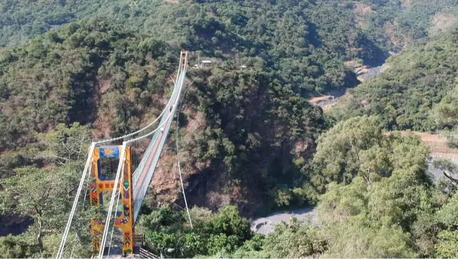
Duona Suspension Bridge (aka Duonagao Suspension Bridge 多納高吊橋) is the highest pedestrian suspension bridge in Southeast Asia, featuring amazing views of the Zhuokou River and Maolin's mountainous landscape. The bridge is part of a trail that connects the top of a ridge-line, giving hikers 360 views of the river valley and surrounding landscape.
Background: The Duona Suspension bridge is the highest in Southeast Asia and the highest bridge in Taiwan. It is 232 meters long (761 feet) and 103 meters tall (338 feet). It was completed during the Japanese Colonial Era (early 1900's) and was the main connection between the Rukai tribe living at Duona Village to the rest of Taiwan. The bridge was renovated in 1997 and 2015. Car and scooter traffic have been officially banned after 2015, although local residents still ride over it. Duona Great Bridge sits in the Eagle Valley (老鷹谷) next to Duona Suspension Bridge and allows two lanes of motor traffic. It was completed in 2012. Before it was built, another bridge that crossed the river there was destroyed during the floods of Typhoon Morakot (aka eight-eight flood or 八八水災). Typhoon Morakot brought record floods to Taiwan because it slowly moved over the island delivering torrential rain. Nearly 700 people were killed during the disaster (to see what Maolin looked like right after the flooding, check out this blog here). Basically all the bridges in Maolin were destroyed during Typhoon Morakot in 2009 except Duona Suspension bridge which is built so high that it would never be affected by floodwater. Most all the bridges currently in Maolin were reconstructed after the 2009 floods. Price: Free Hours: 24/7 How to get there: Take Maolin Forest Road (Kaohsiung City Road 132) to Wanshan Village, after which turn left toward Meiya Valley 美雅谷 at the top of the ridge, and continue right until you come to the suspension bridge. Technically you should park your car there and walk to the suspension bridge, but there are also spots to park closer to the bridge. Looking for scooter rental in Kaohsiung? You can check out Klook here or KKday here to search for options. You can check also out our scooter rental guide here. If you are looking for car rentals, you can search Qeeq here, KKday here, or Klook here. You can also check out our car rental guide here. Accommodation We have stayed at and recommend Chao She Hotel (you can book on Agoda here, Booking.com here, Hotels.com here, or Expedia here) IHI Sanduo Travel Hotel (you can book on Agoda here, Booking.com here, Hotels.com here, or Expedia here), and Mingli Hotel (you can book on Agoda here, Klook here, or Hotels.com here) which are three inexpensive and high quality choices in downtown Kaohsiung. I also have stayed at and recommend Kaohsiung Meinong Rabbit Paul Homestay B&B (you can book on Agoda here, Booking.com here, or Trip.com here), a quiet B&B in rural Meinong, and Chengching Lakeside Resort (you can book on Agoda here, Booking.com or Trip.com here)and the Grand Hotel Kaohsiung (you can book on Agoda here, Booking.com here, Hotels.com here, or Expedia here) which both offer breakfast buffet and free entrance into Chenqing Lake Park. I have also stayed at the 85 sky tower which offers great views of the city; you can search for rooms in the 85 sky tower on Agoda here, Booking.com here, Hotels.com here, Expedia here, or Trip.com here). Find out more about where to stay in our Taiwan hotels guide or search for the best hotel deals in Taiwan here. We recommend booking through Agoda here, which provides the best quality selection of accommodation on the islands. You can also book Wifi and SIM cards for Taiwan on Gigago here. Need travel insurance? Compare prices on Insubuy here. Tours: You can find more tours and activities in Kaohsiung such as Pier 2, Meinong Hakka Museum, Hamasen Railway Museum, Suzuka Circuit Park, i-Ride Kaohsiung Visual 5D Flying Theater, National Science and Technology Museum , Senya Village Restaruant, Austin Land, Ski School Indoor Ski Slope, and many more on Klook here or KKday here. Just to let you know, if you book using the links above, we get some commission at no cost to you, and you can help support our blog. You can click here to receive $5 USD on your first Klook purchase. Map: Please see below: 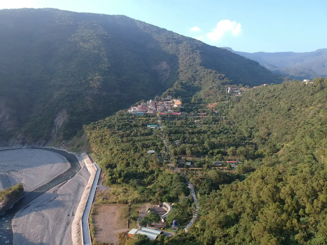
Maolin District of Kaohsiung City is my favorite place in Taiwan, and in Maolin I have spent the most time in Wanshan Village, thanks to a man named Ahbei.
Wanshan is a small village that lies on a mountain slope between Maolin Village and Duona Village. Near the village are waterfalls, streams, hot springs, and great views. Popular activities include swimming, hot spring bathing, river tracing, camping, and hiking. Background: Wanshan has the smallest population of any village in Taiwan according to the government website here, with a population of just 450 people. 95% of the people are aborigines from the Rukai Tribe (魯凱族), and the rest are either from the Wulu Bunun Tribe (布農) or Han Chinese. Originally the people of Wanshan village lived at the base of Mali Mountain (麻里山), but were moved by the government in 1956 to their current location. Many of the inhabitants of Maolin were originally located elsewhere, but had to relocate their home or village due to typhoons or unsafe terrain. There are a few abandoned villages around Maolin that you can still hike to. One special thing about Wanshan Village is that the intercom speaker from the elementary school (the only school in the village) is within earshot of everyone that lives in the village, so communication from the village leadership is easily passed on (and everyone gets woken up by it in the morning). Price: Free Hours: 24/7 When to go: I recommend going in the summer time when the waterfalls have plenty of water and warm temperatures make it a great time to go swimming. In winter it will be cold and the waterfalls can dry up. However in summer be careful of Typhoons. If there is a Typhoon, the inhabitants of Maolin will be evacuated, and you should not try to go in for your own safety. On the other hand if you want to go just for hiking, winter would be a better time to go. If you are coming to see butterflies, the butterfly migration is in the fall and ends roughly in November. How to get there: By Car: Maolin can be reached via provincial highway 27 from Pingtung or Liugui. Once you come to Dajin Bridge, go straight up the mountain. Looking for scooter rental in Kaohsiung? You can check out Klook here or KKday here to search for options. You can check also out our scooter rental guide here. If you are looking for car rentals, you can search Qeeq here, KKday here, or Klook here. You can also check out our car rental guide here. By Bus: You can take a bus there but I don't recommend it. It's a 3 hour bus ride from Pingtung Bus Station. If you can rent a car or scooter it is about a 1.5 hour drive from downtown Kaohsiung. You can book tickets to travel to Kaohsiung via inter-city bus on Klook here. You can book tickets to Kaohsiung via high speed rail (HSR) on Klook here or KKDay here. Book tickets via the normal train (TRA) on Klook here. You can also book a Kaohsiung Travel pass here. Accommodation We have stayed at and recommend Chao She Hotel (you can book on Agoda here, Booking.com here, Hotels.com here, or Expedia here) IHI Sanduo Travel Hotel (you can book on Agoda here, Booking.com here, Hotels.com here, or Expedia here), and Mingli Hotel (you can book on Agoda here, Klook here, or Hotels.com here) which are three inexpensive and high quality choices in downtown Kaohsiung. I also have stayed at and recommend Kaohsiung Meinong Rabbit Paul Homestay B&B (you can book on Agoda here, Booking.com here, or Trip.com here), a quiet B&B in rural Meinong, and Chengching Lakeside Resort (you can book on Agoda here, Booking.com or Trip.com here)and the Grand Hotel Kaohsiung (you can book on Agoda here, Booking.com here, Hotels.com here, or Expedia here) which both offer breakfast buffet and free entrance into Chenqing Lake Park. I have also stayed at the 85 sky tower which offers great views of the city; you can search for rooms in the 85 sky tower on Agoda here, Booking.com here, Hotels.com here, Expedia here, or Trip.com here). Find out more about where to stay in our Taiwan hotels guide or search for the best hotel deals in Taiwan here. We recommend booking through Agoda here, which provides the best quality selection of accommodation on the islands. You can also book Wifi and SIM cards for Taiwan on Gigago here. Need travel insurance? Compare prices on Insubuy here. Tours: You can find more tours and activities in Kaohsiung such as Pier 2, Meinong Hakka Museum, Hamasen Railway Museum, Suzuka Circuit Park, i-Ride Kaohsiung Visual 5D Flying Theater, National Science and Technology Museum , Senya Village Restaruant, Austin Land, Ski School Indoor Ski Slope, and many more on Klook here or KKday here. Just to let you know, if you book using the links above, we get some commission at no cost to you, and you can help support our blog. You can click here to receive $5 USD on your first Klook purchase. Map: Please see below: 
Duona Village in Maolin (Aka Duona Tribe, Tona, or Kungadavane 多納部落) is one of the oldest inhabited tribal villages in Taiwan, home to people of the Rukai Tribe. The village features a street full of traditional foods and restaurants, intact aboriginal culture, traditional stone houses, as well as nearby rivers, waterfalls, and hiking trails for tourists to explore.
Background: Duona is the most remote village in Maolin District of Kaohsiung City, and is said to harbor the most complete version of the Rukai Aborigine culture. The Rukai People first began to move into the area now known as Duona about 300 years ago (1700s), making it one of the oldest aborigine villages in Taiwan. Most of the people live in traditional stone houses made from nearby plentiful shale rock, which are characteristic of the Rukai Tribe. The stone houses are warm in the winter and stay cool during the summer. Near the village is a small plain which is said to be the home of Taiwan's indigenous species of black rice. The village was almost completely cut off from the outside world until the Japanese built the Duona Suspension Bridge, which helped to link it to the rest of Taiwan as well as better control the native population. The village sits at about 450 meters above sea level and has around 600 inhabitants. There is one elementary school in the village (its only educational institution) and one police station. The actual village boundaries extend to Pingtung County and Taitung County, and include largely untouched and "virgin" forests and mountain wilderness areas such as Shuang-guei Lake, providing precious wildlife habitat for many of Taiwan's indigenous animals and plants. Hours: 24/7. However most of the restaurants on Duona Alley are only open from 8 AM to 5 PM. Accommodation We have stayed at and recommend Chao She Hotel (you can book on Agoda here, Booking.com here, Hotels.com here, or Expedia here) IHI Sanduo Travel Hotel (you can book on Agoda here, Booking.com here, Hotels.com here, or Expedia here), and Mingli Hotel (you can book on Agoda here, Klook here, or Hotels.com here) which are three inexpensive and high quality choices in downtown Kaohsiung. I also have stayed at and recommend Kaohsiung Meinong Rabbit Paul Homestay B&B (you can book on Agoda here, Booking.com here, or Trip.com here), a quiet B&B in rural Meinong, and Chengching Lakeside Resort (you can book on Agoda here, Booking.com or Trip.com here)and the Grand Hotel Kaohsiung (you can book on Agoda here, Booking.com here, Hotels.com here, or Expedia here) which both offer breakfast buffet and free entrance into Chenqing Lake Park. I have also stayed at the 85 sky tower which offers great views of the city; you can search for rooms in the 85 sky tower on Agoda here, Booking.com here, Hotels.com here, Expedia here, or Trip.com here). Find out more about where to stay in our Taiwan hotels guide or search for the best hotel deals in Taiwan here. We recommend booking through Agoda here, which provides the best quality selection of accommodation on the islands. You can also book Wifi and SIM cards for Taiwan on Gigago here. Need travel insurance? Compare prices on Insubuy here. Tours: You can find more tours and activities in Kaohsiung such as Pier 2, Meinong Hakka Museum, Hamasen Railway Museum, Suzuka Circuit Park, i-Ride Kaohsiung Visual 5D Flying Theater, National Science and Technology Museum , Senya Village Restaruant, Austin Land, Ski School Indoor Ski Slope, and many more on Klook here or KKday here. Just to let you know, if you book using the links above, we get some commission at no cost to you, and you can help support our blog. You can click here to receive $5 USD on your first Klook purchase. How to get there: Take Maolin Forest Road (Kaohsiung City Road 132) past Wanshan Village and continue on to Duona Village, the last town on the road. There will be a left turn onto Duona Alley, the main road in the village. Looking for scooter rental in Kaohsiung? You can check out Klook here or KKday here to search for options. You can check also out our scooter rental guide here. If you are looking for car rentals, you can search Qeeq here, KKday here, or Klook here. You can also check out our car rental guide here. Map: Please see below: 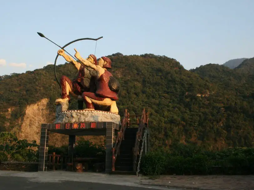
Maolin Village is the first and largest village you come across in the mountainous Maolin District of Kaohsiung. It features an aboriginal cultural sights, waterfalls, swimming holes, delicious food, and much more to be explored by you.
This blog is the first of a 5 part blog series that I will share about my favorite place in Taiwan, Maolin. Background: During the Japanese occupation, some of the original inhabitants of Maolin Village live in the mountains behind Wanshan Village. However later these aboriginals were forcibly moved to the current village. Many of the inhabitants were originally located elsewhere, but had to relocate their home or village due to typhoons or unsafe terrain. There are a few abandoned villages above the current village that you can still hike to. The village covers the area from Dajin Bridge 大津橋 to Maolin Valley 茂林谷, and has about 850 inhabitants, mostly aboriginals from the Rukai (魯凱族) Wulu Bunun (布農) and Paiwan (排灣) tribes, as well as some Han Chinese people. The village also has Maolin Middle school, the only middle school, and highest education institution in Maolin District. Price: Free Hours: 24/7 When to go: I recommend going in the summer time when the waterfalls have plenty of water and warm temperatures make it a great time to go swimming. In winter it will be cold and the waterfalls can dry up. On the other hand if you want to go just for hiking, winter would be a better time to go. If there is a Typhoon, the inhabitants of Maolin will be evacuated, and you should not try to go in for your own safety. If you are coming to see butterflies, the butterfly migration is in the fall and ends roughly in November. How to get there: By Car: Maolin can be reached via provincial highway 27 from Pingtung or Liugui. Once you come to Dajin Bridge, go straight up the mountain. Looking for scooter rental in Kaohsiung? You can check out Klook here or KKday here to search for options. You can check also out our scooter rental guide here. If you are looking for car rentals, you can search Qeeq here, KKday here, or Klook here. You can also check out our car rental guide here. By Bus: You can take a bus there but I don't recommend it. It's a 3 hour bus ride from Pingtung Bus Station. If you can rent a car or scooter it is about a 1 1/2 hour drive from Kaohsiung. You can book tickets to travel to Kaohsiung via inter-city bus on Klook here. You can book tickets to Kaohsiung via high speed rail (HSR) on Klook here or KKDay here. Book tickets via the normal train (TRA) on Klook here. You can also book a Kaohsiung Travel pass here. Accommodation We have stayed at and recommend Chao She Hotel (you can book on Agoda here, Booking.com here, Hotels.com here, or Expedia here) IHI Sanduo Travel Hotel (you can book on Agoda here, Booking.com here, Hotels.com here, or Expedia here), and Mingli Hotel (you can book on Agoda here, Klook here, or Hotels.com here) which are three inexpensive and high quality choices in downtown Kaohsiung. I also have stayed at and recommend Kaohsiung Meinong Rabbit Paul Homestay B&B (you can book on Agoda here, Booking.com here, or Trip.com here), a quiet B&B in rural Meinong, and Chengching Lakeside Resort (you can book on Agoda here, Booking.com or Trip.com here)and the Grand Hotel Kaohsiung (you can book on Agoda here, Booking.com here, Hotels.com here, or Expedia here) which both offer breakfast buffet and free entrance into Chenqing Lake Park. I have also stayed at the 85 sky tower which offers great views of the city; you can search for rooms in the 85 sky tower on Agoda here, Booking.com here, Hotels.com here, Expedia here, or Trip.com here). Find out more about where to stay in our Taiwan hotels guide or search for the best hotel deals in Taiwan here. We recommend booking through Agoda here, which provides the best quality selection of accommodation on the islands. You can also book Wifi and SIM cards for Taiwan on Gigago here. Need travel insurance? Compare prices on Insubuy here. Tours: You can find more tours and activities in Kaohsiung such as Pier 2, Meinong Hakka Museum, Hamasen Railway Museum, Suzuka Circuit Park, i-Ride Kaohsiung Visual 5D Flying Theater, National Science and Technology Museum , Senya Village Restaruant, Austin Land, Ski School Indoor Ski Slope, and many more on Klook here or KKday here. Just to let you know, if you book using the links above, we get some commission at no cost to you, and you can help support our blog. You can click here to receive $5 USD on your first Klook purchase. Map: Please see below: 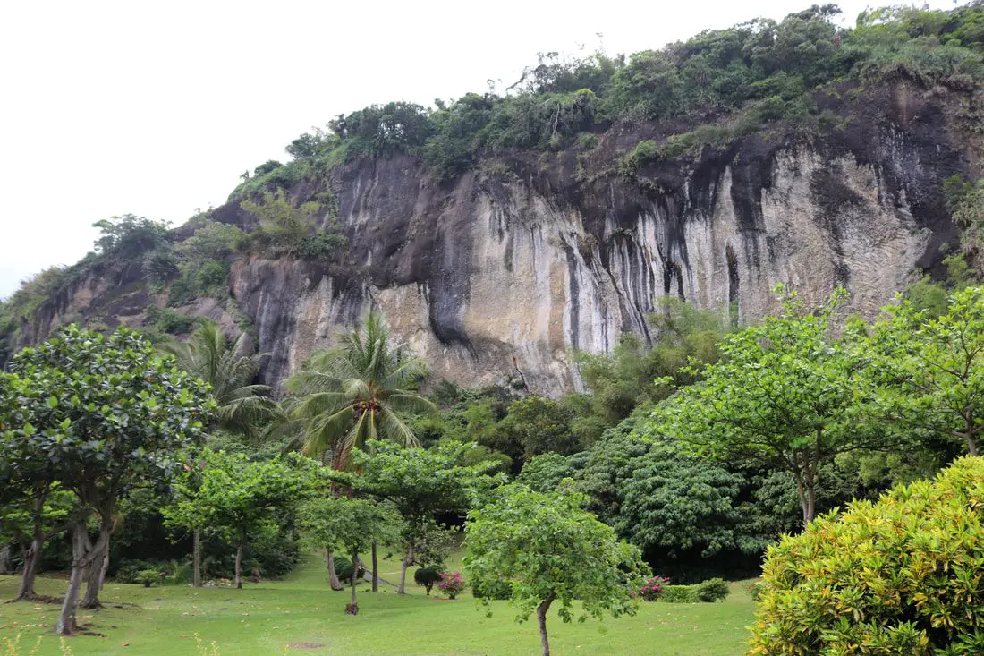
The Baxian Caves (aka Baxiandong) on the east coast in Taitung County have the earliest evidence of humans living in Taiwan, including stone tools dating back to over 30,000 years ago. In recent times the caves were converted into Taiwan folk religion temples, but now all of the 30 caves in the area have been reclaimed by the government to preserve this important archaeological site. The area is now open to the public, and there are trails and a large park in front of the caves.
Background: The Baxian Caves were originally underwater until geological forces between the Philippine and Eurasian tectonic plates forced the ground upward. The first traces of people living here date back to 30,000 years ago during the late Paleolithic age. They were thought to have crossed a land bridge between what is now Fujian Province of China and Taiwan, and created what is known as the Changbin Culture, and stayed here until about 1500 years ago during the late stone age. After that, their culture mysteriously disappeared. The people that lived in the caves were mostly hunter-gatherers that used stone tools, and used the caves as shelter. Later the area was inhabited by the Amis Aboriginie Tribe (阿美族) who have lived there since at least 1500 BC, and called the area Lohan, which means caves. After the area was settled by Han Chinese farmers, there arose a legend that the caves were home to the eight immortals (八仙 Baxian), from where the caves now get their name and many temples were built in the caves here, as well as to other gods such as the Earth God, Buddha, Guanyin, and others. Price: Free Parking: 60 NT for cars, 20 NT for scooters. You can book a tour to Taitung with Klook here or KKday here. Hours: 8:30 AM PM every day. How to get there: By Car/Scooter: We recommend taking Provincial Highway 11 from Taitung north 30km to the caves. Feel free to stop and enjoy the scenery along the way. You can also try to coming south down from Hualien. Looking for scooter rental in Taitung? You can search Klook here or KKday here to search for options. You can also check out our scooter rental guide here. If you are looking for car rentals, you can also search KKday here or Klook here. You can check out our car rental guide here. By Bus: You can take bus 8102 or 8103 from Taitung, but according to Google this will take about 3 hours. You can also try to coming south down from Hualien. You can book tickets to travel to Taitung via inter-city bus on Klook here. Book tickets via the normal train (TRA) on Klook here. Accommodation: Booking accommodation in the Taitung can be difficult in the summer months and on weekends when rooms can be fully booked for months in advance. We suggest a better quality selection on Agoda.com. We have stayed at and recommend the Papago International Resort in Chishang (you can book on Agoda here, Booking.com here, Hotels.com here, or Expedia here), which is a five star hotel with private villas with pools for each room, and Mountain and Ocean B & B in Taimali (you can book on Agoda here, Booking.com here, Hotels.com here, or Expedia here), which is a quiet and affordable B&B right next to the beach. You can also book Wifi and SIM cards for Taiwan on Gigago here. Need travel insurance? Compare prices on Insubuy here. Tours: There are many tours and activities such as snorkeling, diving, SUPing, Surfing, Speed Boating, Glamping, River tracing and more in Taitung. You can find more tours of Taitung on Klook here or KKday here. Just to let you know, if you book using the links above, we get some commission at no cost to you, and you can help support our blog. You can click here to receive $5 USD on your first Klook purchase. Map: Please see the map below: 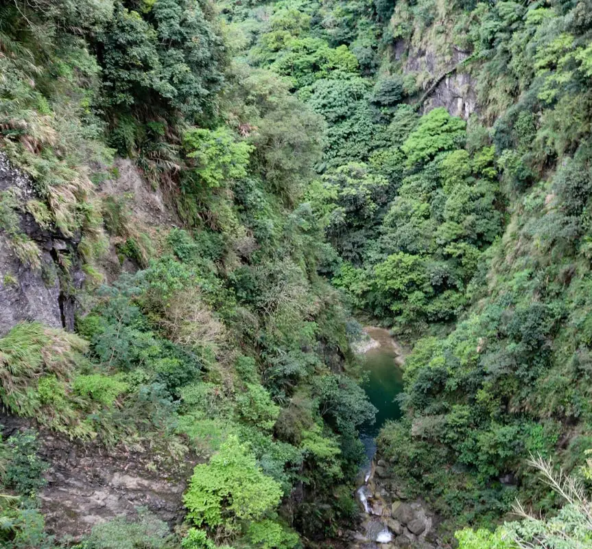
Fanshuliao in Hualien is the most unique looking canyon on the east coast, and is a popular river tracing spot. The canyon is over 100 meters deep, and metal steps have been hammered into the canyon wall for those brave enough to walk down them.
Background: The Canyon at Fanshuliao is 100 meters deep and 45 meters wide. It was formed by loose volcanic rock, which erodes easily, which helped to create the canyon. The Amis aborigine people that lived here sais that any young man that could traverse the canyon in one leap using a bamboo stick would become the village chief. Because of this, many young men fell to their death, and a pile of bamboo sticks began to pile up at the bottom of the canyon known as the "forest of lost brave ones." Highway 11, also known as the Hualien-Taitung Coastal Highway, first began as a trail during the Qing Dynasty in 1877. During the Japanese era of Taiwan, the road was improved and open to vehicles in 1930. The current two lane highway as we know it today was completed after WWII in 1968. The Fanshuiliao rest area (named after the nearby Fanshu village) was probably also completed at that time. It is a popular stop along the highway, and the Fanshuliao River is a popular river tracing destination. Hours: 24/7 Price: Free How to get there: By car/scooter: Travel along Highway 11 until you reach the spot. There is usually plenty of free parking here. Looking for a scooter rental in Hualien? You can search KKday here or Klook here to look for options. You can also check out our scooter rental guide here. If you are looking for car rentals in Hualien, you can also search Klook here or KKDay here. You can also check out our car rental guide here. By bus: There is a stop here on Bus 304's route, or take bus 1140 from Hualien Station to Fanshuliao bus stop. You can book tickets to travel to Hualien via inter-city bus on Klook here. Book tickets via the normal train (TRA) on Klook here. Where to stay? Most of the accommodation you will find is near the city center. If you only want to visit Hualien City and Taroko Gorge, you can consider booking a hotel near downtown, walking or cycling around the city, and taking a bus to Taroko Gorge. We have stayed at and recommend Dream Taiwan Homestay (Agoda / Booking.com / Expedia / Hotels.com), a high quality hostel for the money in downtown Hualien, Farglory Hotel (Agoda / Booking.com / Expedia / Hotels.com), right next to Farglory Ocean Park with amazing views of Hualien, and Goldenflower B&B (Agoda / Booking.com) in Yuli right next to Sixty Stone Mountain. You can find out where to stay in our Taiwan hotels guide or search for the best hotel deals in Taiwan here. You can also book Wifi and SIM cards for Taiwan on Gigago here. Need travel insurance? Compare prices on Insubuy here. Tours: You can find more tours and activities in Hualien such as River Tracing, Surfing, Paragliding, SUP / Paddle Boarding, Kayaking, Canoeing, and much more on Klook here or KKday here. Map: Please see below: 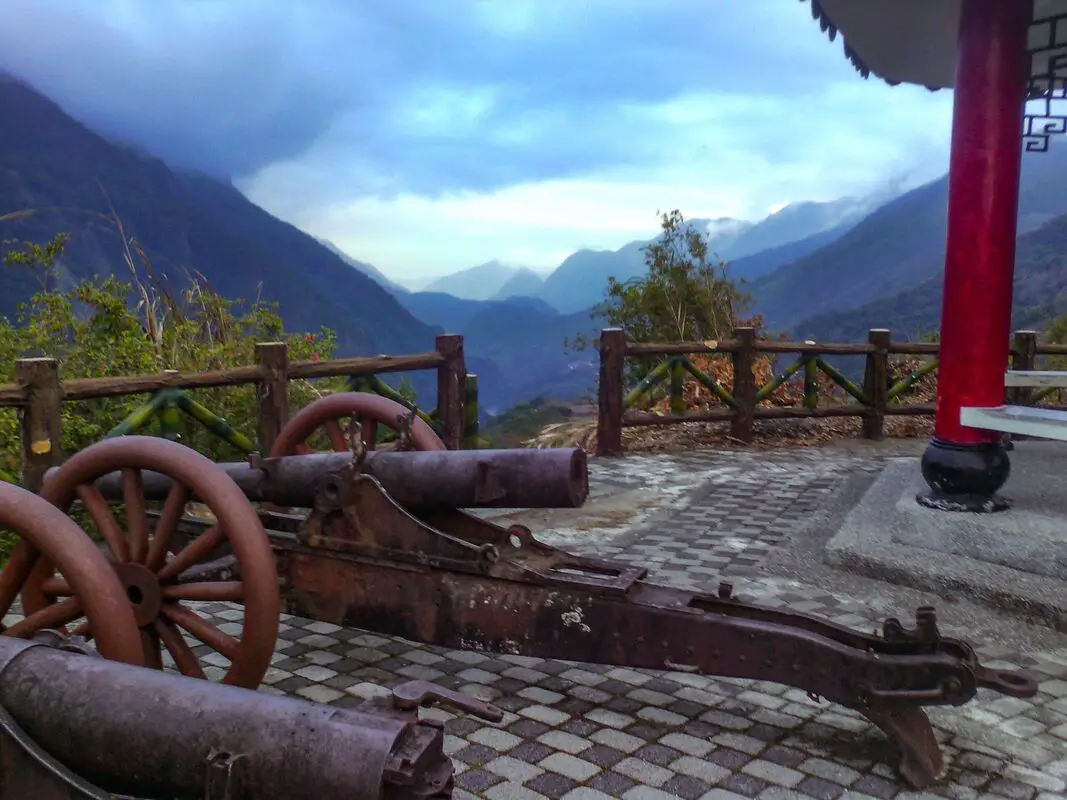
Wulu Fort in Haiduan Township of Taitung County was originally made by the Japanese to suppress an uprising by the Bunun indigenous tribe. Now it stands as a monument to Taiwan's colonial past. The area also has great views of the Wulu Gorge and Wulu Village along Taiwan's South Cross-Island Highway.
Historical Background: As per the sign on sight, the history of Wulu Fort is as follows: "Wulu Battery was constructed in 1927 when the Japanese were building the Guanshan Cross-Ridge TRail (now the South Cross-Island Highway) from Xinwu to Wulu. This cannon, manufactured by the Russians in 1903, was captured by the Japanese during the Russio-Japanese War and shipped to Taiwan for the Japanese Police to use in the suppression of an uprising of the aboriginal Bunun tribe. Batteries were also built in neighboring Saku (Dalun) and Madiangulu (Motian); but Wulu Battery is the only one that has survived, a witness to the bloody and tragic history of the Japanese occupation." Usually, this area is not crowded. If you visit, it is likely you will be the only person there. Price: Free Hours: 24/7 How to get there: By Car/Scooter: From Taitung, take provincial highway 9 north until you reach provincial highway 20 (South Cross-Island Highway) then turn west up into the mountains. Turn off at Wulu Village. The fort is just above the elementary school. Looking for scooter rental in Taitung? You can search Klook here or KKday here to search for options. You can also check out our scooter rental guide here. If you are looking for car rentals, you can also search KKday here or Klook here. You can check out our car rental guide here. By Bus: From Guanshan TRA station, you can take bus 8178 to Wulu. The Fort is about a 25 minute walk from the bus station. You can book tickets to travel to Taitung via inter-city bus on Klook here. Book tickets via the normal train (TRA) on Klook here. Accommodation: Booking accommodation in the Taitung can be difficult in the summer months and on weekends when rooms can be fully booked for months in advance. We suggest a better quality selection on Agoda.com. We have stayed at and recommend the Papago International Resort in Chishang (you can book on Agoda here, Booking.com here, Hotels.com here, or Expedia here), which is a five star hotel with private villas with pools for each room, and Mountain and Ocean B & B in Taimali (you can book on Agoda here, Booking.com here, Hotels.com here, or Expedia here), which is a quiet and affordable B&B right next to the beach. Find out where to stay in our Taiwan hotels guide or search for the best hotel deals in Taiwan here. You can also book Wifi and SIM cards for Taiwan on Gigago here. Need travel insurance? Compare prices on Insubuy here. Tours: There are many tours and activities such as snorkeling, diving, SUPing, Surfing, Speed Boating, Glamping, River tracing and more in Taitung. You can find more tours of Taitung on Klook here or KKday here. Just to let you know, if you book using the links above, we get some commission at no cost to you, and you can help support our blog. You can click here to receive $5 USD on your first Klook purchase. Map: 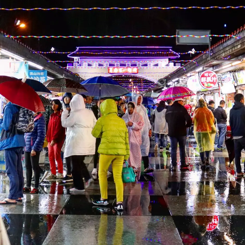
Hualien‘s Dongdamen Night Market is the largest night market in Eastern Taiwan. It is actually four night markets in one. The night market lies on the spot of a former train station, and is also connected to the beach via pedestrian bridge. Popular delicacies here include fried chicken, shish kabab, coffin bread, and braised duck head.
Background: Dongdamen gets it's name because it lies on the east side of the city, literally meaning "east gate" however Hualien has never had walls or gates. Dongdamen Night Market was formed in 2015 over the site of the former Hualien TRA train station. The Night Market features four night markets in one: Fuding Night Market, Aborigine Street, Gesheng Street, and Ziqiang Night Market. The night market has over 400 stalls and sees over 200,000 visitors per month. Hours: 5:30 PM to 11:30 PM open every day. Price: Free When to visit? Hualien is great year round, but it can get a little hot in the summer, and Typhoon season and heavy rain season last from about May to October. If you are afraid of the heat and rain then you can visit during winter when the temperatures are mild and the climate is usually dryer. Where to stay? Most of the accommodation you will find is near the city center. If you only want to visit Hualien City and Taroko Gorge, you can consider booking a hotel near downtown, walking or cycling around the city, and taking a bus to Taroko Gorge. We have stayed at and recommend Dream Taiwan Homestay (Agoda / Booking.com / Expedia / Hotels.com), a high quality hostel for the money in downtown Hualien, Farglory Hotel (Agoda / Booking.com / Expedia / Hotels.com), right next to Farglory Ocean Park with amazing views of Hualien, and Goldenflower B&B (Agoda / Booking.com) in Yuli right next to Sixty Stone Mountain. You can find out where to stay in our Taiwan hotels guide or search for the best hotel deals in Taiwan here. You can also book Wifi and SIM cards for Taiwan on Gigago here. Need travel insurance? Compare prices on Insubuy here. How to get there: By Car/Scooter: The night market lies on the central eastern part of the city along Chungshan Road and Chongching Road. There is free car parking inside and free scooter parking too. Looking for a scooter rental in Hualien? You can search KKday here or Klook here to look for options. You can also check out our scooter rental guide here. If you are looking for car rentals in Hualien, you can also search Klook here or KKDay here. You can also check out our car rental guide here. By Train: From Hualien TRA station, take bus 301, or walk about 30 minutes. You can book tickets to travel to Hualien via inter-city bus on Klook here. Book tickets via the normal train (TRA) on Klook here. Tours: You can find more tours and activities in Hualien such as Surfing, Paragliding, SUP / Paddle Boarding, Kayaking, Canoeing, River Tracing, and much more on Klook here or KKday here. See the map below: 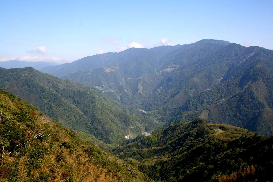
Smangus is an Ayatal tribal village deep in the mountains of Hsinchu. At an altitude of 1500 meters above sea level, it is also known as Taiwan's most remote aboriginal village. It has become a tourist hot spot not only for the aboriginal culture here, but also for the grove of giant Cypress trees which are close to 3,000 years old.
Background: The name Smangus is the Ayatal name of the Netleaf Oak tree (querus rugosa 銳葉高山櫟) that grows here. The Ayatal tribe has inhabited this area for thousands of years. After the ROC took control of Taiwan, most of the tribe converted to Christianity thanks to western missionaries. The village of Smangus was electrified only in 1979, and a road to the village was only completed in 1995. Before that, it was a three hour walk to the nearest town. After word got out about the grove of giant Cypress trees in the area, the village quickly became a tourist hot spot and remains so today. Price: Free Tours: You can book a tours to Smangus on Klook here. Where to stay: Most of the accommodation you will find is near the city center. If you will only visit downtown, you can consider a day trip from Taipei. We have stayed at and recommend the Golden Motel a high quality motel near Green Grass Lake (you can book on Agoda here, Booking.com here, Hotels.com here, Expedia here, or Trip.com here), and CD Motel, another high quality motel in downtown Hsinchu (you can book on Agoda here, Booking.com here, or Trip.com here). Unfortunately I cannot recommend any further hotels that I have stayed at in Hsinchu because usually we stay at my wife's uncle's house. You can find out where to stay in our Taiwan hotels guide or search for the best hotel deals in Taiwan here. You can also book Wifi and SIM cards for Taiwan on Gigago here. Need travel insurance? Compare prices on Insubuy here. Just to let you know, if you book using the links above, we get some commission at no cost to you, and you can help support our blog. You can click here to receive $5 USD on your first Klook purchase. How to get there: By car/scooter: From eastern Hsinchu, take highway 109 to Jianshi Township until you reach the turnoff to Smangus. It's about a 2 hour drive from Guanxi township in Hsinchu. If you are looking for car rentals in Hsinchu, you can also search Qeeq here, Klook here, or KKDay here. You can also check out our car rental guide here. Looking for scooter rental in Hsinchu? You can search Klook here or KKday here to look for options. You can also check out our scooter rental guide here. Bus: There is no public transportation to Smangus. You can book tickets to travel to Hsinchu via inter-city bus on Klook here. You can book tickets to Hsinchu via high speed rail (HSR) on Klook here or KKDay here. Book tickets via the normal train (TRA) on Klook here. Bicycle: Cycling is the best way to enjoy Taiwan's landscapes if you have the time and energy. Looking for bicycle rentals in Taiwan? You can search on KKday here and Klook here. You can also check out our Taiwan cycling guide here. Tour: You can take a day tour to Smangus with Klook here. Map: Please see below: 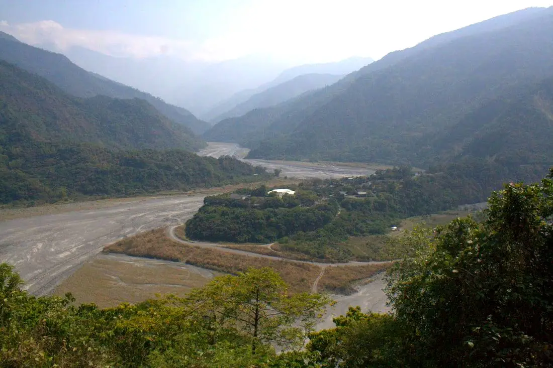
The Taiwan Indigenous Peoples Cultural Park in Machia Township of Pingtung is a large area in southern Taiwan that has traditional aboriginal villages, museums, exhibitions, live performances, artwork, and indigenous cuisine, as well as amazing mountain scenery. If Taiwan's biggest tourism draw is indigenous culture, then this place is a must stop on your trip to Taiwan.
Background: Taiwan Indigenous peoples have inhabited Taiwan for over 10,000 years. After Chinese and Japanese colonialism, they were pushed back mainly to the mountains. There are currently 16 officially recognized tribes, and a population of over 500,000 people, making about 2.5% of Taiwan's population. The Taiwan Indigenous Peoples Cultural Park was established in 1987, and is 82.65 hectares. It includes museums, live shows, and shops showcasing Taiwan Indigenous culture. The park is located in Machia Township of Pingtung, and is nearby Sandimen, a township also know for its indigenous culture. Tours and Activities in Pingtung: There are many activities available in Pingtung, such as snorkeling, diving, SUPing, surfing, submarine riding, and river tracing. You can find more tours of Kenting on Klook here or KKday here. Where to stay: Looking for a hotel? Find out where to stay in our Taiwan hotels guide or search for the best hotel deals in Taiwan here. We recommend booking through Agoda here, which provides the best quality selection of accommodation in Taiwan. I have stayed at many hostels and hotels in Pingtung, and even almost bought a house here. Some places that I have stayed at and can recommend are Nanwan Kiki (book on Agoda here, Booking.com here), a B&B next to Nanwan Bay, Kenting's most popular Beach. There are also a few decent hotels near Kenting Street Night Market like Kenting Star Inn 888 (book on Agoda here, Klook here, or Booking.com here), or Kenting Dajianshan Hotel (book on Agoda here or Booking.com here). You will notice that none of these hotels are five star resorts (I do not come to Kenting to waste my time at a resort, but you can still search Agoda, Booking.com, or Klook here for those) but they are in my opinion the above have the best value for the money. How to Get There: Bus: From Pingtung you can take bus 8232, 8337, or 8233 toward Sandimen but it is about a 20 minute walk from the bus stop. You can book tickets to Pingtung via high speed rail (HSR) on Klook here or KKDay here, or book tickets via the normal train (TRA) on Klook here. You can book tickets to travel to Pingtung via inter-city bus on Klook here. By Bicycle: Cycling is the best way to enjoy Taiwan's landscapes if you have the time and energy. Looking for bicycle rentals in Taiwan? You can search on KKday here and search for tours on Klook here. You can also check out our Taiwan cycling guide here. By Car/scooter: From Pingtung City, take provincial highway 24 toward Sandimen and then turn on to Fengjing Lane. There is parking in front of the entrance. Looking for scooter rental in Pingtung? Click here or here to search for options. You can also check out our scooter rental guide here. If you are looking for car rentals, you can also search Qeeq here, Klook here, or KKday here. You can also check out our car rental guide here. Price: 150 NT per person Hours: 8:30 AM to 5 PM, closed Mondays. Map: Please see below:
Now that I have finished blogs about Maolin Village, Wanshan Village, Duona Suspension Bridge, and Duona Village (click the links to see each individual blog), I would like to finish this Maolin blog series by sharing a piece of writing I wrote for a class in college after just getting back from a trip to Taiwan in 2013, a time when I was especially missing Maolin. I hope this post does justice to the place I love most in Taiwan.
Ode to Maolin 茂林之頌: The walls of my room are closing in on me, closer, closer, crushing down. The window disappears. Then the door bursts open, a storm of nothing but boulders hit my skull one after another like baseballs at the batting cages. The room collapses onto my paper body. BANG! BANG! The ceiling crushes me into a paper ball, in the darkness. A board with nails terrorizes my head, I can't pull it out of my skull, and the nails sink in. Poison in my brain. Have to work to eat tons of homework on me so that one day decent job and buy things for me and pay for their college and my retirement swimming pool up with the jones’ car second house but crappy major. I feel my stone necklace that shines bright and silver in the darkness; it reminds me of a better place. 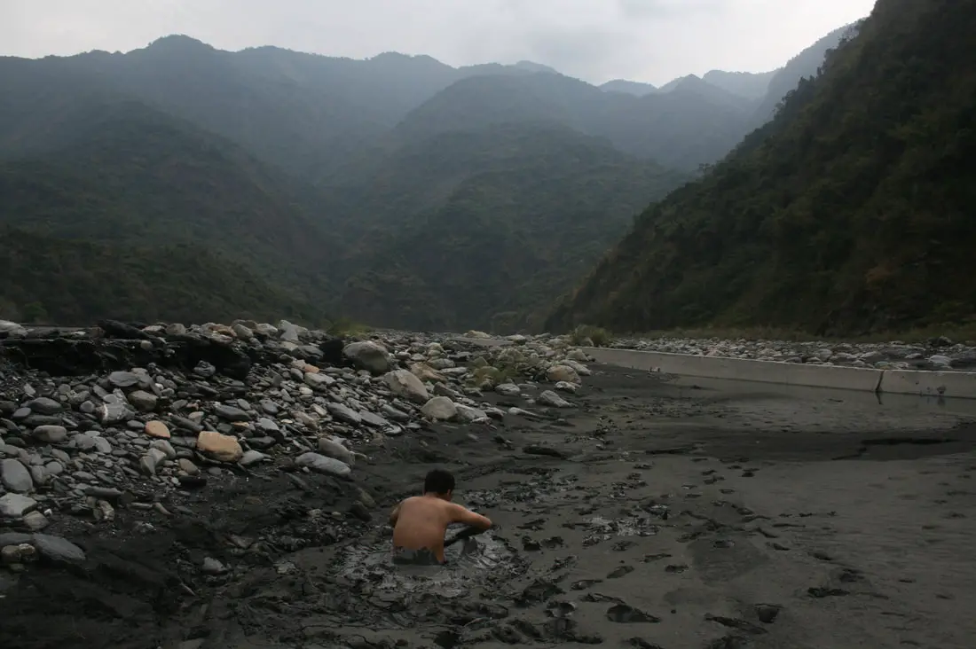
|
Author 作家I am an American expat who has extensive experience living, working, and traveling in Taiwan. In my day, I had to learn many things about Taiwan the hard way. But I have come to learn that Taiwan is one of the best places in the world for Foreigners to live. This blog does not represent the opinions of every foreigner in Taiwan. I am just trying to help others learn more about this beautiful country. Categories
|
 RSS Feed
