

In Taiwan, funerals and death rituals are very different that funerals in the west. Taiwan's funeral rites are influenced by Buddhism, Taoism, ancestor worship, and folk religion. In this blog, we will explore the different funeral rituals and rites, and let you know what you can expect at a Taiwanese funeral.
Foreword: Please note this blog and FAQ section are written from the perspective of a long-term American expat married to a Taiwanese spouse. Part of the facts for this blog have been taken from personal experience attending multiple funerals in Taiwan, and also from research such as Chinese anthropology classes and other research.
3 Comments
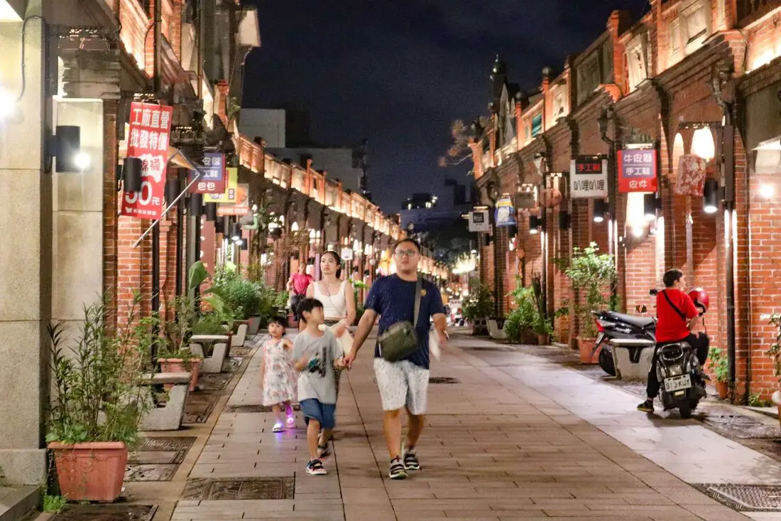
Sanxia Old Street is one of the best-preserved Old Streets in Taiwan, with two rows of buildings that have recently been renovated in their original Japanese-era baroque-style architecture. Here you can also enjoy local delicacies Ox Horn Bread and other Taiwanese staples such as sausages, ice cream, stinky tofu, and more.
Background: The name Sanxia (三峽, literally meaning "three valleys") comes because the area is surrounded on three sides by mountains. In the mid-1700s, the first Chinese families began to settle in what is now Sanxia. In 1769 Zushi Temple (祖師廟) was established, which is the main temple on the old street. In 1785, the Earth God Temple / Sanxia Fu An Temple (土地公 /三峽福安宮) was established. During the Qing Dynasty, the town of Shenkeng was an important trading area for camphor, tea, and cloth, Transportation was made easy thanks to the Sanxia River. During the Japanese invasion of Taiwan in 1895, local residents retaliated against the Japanese army, inflicting heavy casualties. In return, the Japanese burned Sanxia Old Street. Under Japanese rule, the area underwent improvements, and houses were built in baroque-style architecture. With the establishment of the round island railway, Sanxia Old Street lost its importance as a trade and transportation hub. In 2004, the Taipei County Government allocated 3 Billion NTD to repair and restore the baroque-style architecture on Sanxia Old Street, and the renovations were completed in 2007. In 2009, further renovations were conducted to make the old street as it appears today. At 260 meters long, it is said to be Taiwan's longest preserved old street (I am not sure if this is true). Now the area is a popular tourist attraction and is very busy on weekends and holidays. Delicacies: Ox Horn Bread and other Taiwanese staples such as sausages, ice cream, stinky tofu, and more. Hours: Every Day from about 10 AM to 7:30 PM, with more shops opening later in the day. Price: Free When to go: If you go during weekends or holidays, it can get really crowded but that is also the time when most all of the shops and stalls are open. If you want to avoid the crowds you can try going early in the afternoon when it is not as busy, Tours: You can book a day tour to Sanxia on TripAdvisor here or KKday here. You can also book a river tracing experience in Sanxia on Klook here. There are also free tours in Chinese offered by the local municipal office on Saturdays and Sundays. Hotels in Taipei: We have stayed at and recommend the Yuanshan Grand Hotel, once the tallest building in Taiwan and still the most grand (book on Booking.com here, Agoda here, or Kayak here). We have stayed at and also recommend Fu Chang Hotel in Ximending, which is within walking distance of Ximending shopping district (book on Booking.com here, Agoda here, or Kayak here). Looking for a hotel? We recommend booking through Booking.com here, which provides the best quality selection of accommodation in Taiwan. Find out where to stay in our Taiwan hotels guide or search for the best hotel deals in Taiwan here. How to get there: By Scooter: From central Taipei. provincial highway 3 southwest from Tucheng to Sanxia. The old street is right in the middle of town. You can park for free on the side of the road nearby. Looking for scooter rental in Taipei? You can search on Klook here or KKday here to search for options. You can also check out our scooter rental guide here. By Car: You can take National Highway 3 and get off at the Sanxia exit. There is paid parking under the Sanxia Public Market. If you are looking for car rentals, you can also search Qeeq here, Klook here, or KKday here. You can also check out our car rental guide here. By Bus: There are a number of buses that pass by the old street coming from Taipei, such as bus 910. You can also book tickets to travel to Sanxia via inter-city bus on Klook here. You can also book a Taipei Sightseeing: Hop On, Hop Off Open Top Bus on TripAdvisor here. By Bicycle: Cycling is the best way to enjoy Taiwan's landscapes if you have the time and energy. Looking for bicycle rentals in Taiwan? You can use Taiwan's many Youbike sharing stations, or search for rentals on KKday here, and search for tours on Klook here. You can also check out our Taiwan cycling guide here. You can also book a Sunset Riverside Bike Ride and Historical Tour, 4 Hour Cycling in Taipei, Ultimate 8-Hour Cycling City Tour, or Taipei City Bike Tour with Night Market Experience on TripAdvisor here. For more information, check out our Taiwan transportation guide here. Map: Please see below: 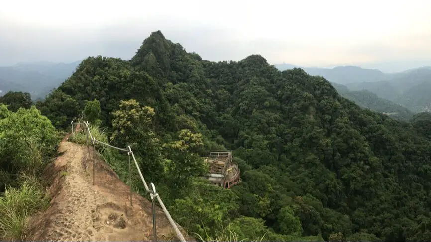
The Huangdidian Trail (aka Huangdi Temple Trail) is a magnificent mountain hike in Shiding District of New Taipei. The trail features ladder climbs, rope climbs, and rock climbs with the aid of ropes, and the top has a vertical drop on either side. There are also great views of Taipei and the surrounding area.
Background: The rock formations that form the Huangdidian hike formed as sediment under the ocean millions of years ago, and was later uplifted thanks to the collision of the Eurasian and Phillipine plates. The rocks are mainly sedimentary and are part of the same formation that forms the special rock formations on the northern coast around Keelung, and the waterfalls in Pingxi. Huangdidian gets its name from the Tianwang Temple below (天王廟) which is also known as the Huangdi Temple (皇帝殿). The Huangdidian trail climbs up Huangdidian Mountain, which has three peaks, the highest of which is 593 meters above sea level. Recently rope railings were installed at the top of the mountain to improve safety. Even so, the hike is still really scary. Hours: 24/7 Price: Free Length: 4.5 KM, 300 meters of elevation gain About three hours total Difficulty: Moderate, there are some rope climbs and ladder climbs up sheer rock face, and sheer drop-off on either side with little protection from falls in some places. Also the trail can be quite steep in some places. Tours: You can book a tour to Shiding on TripAdvisor here, Klook here or KKday here. Hotels in Taipei: We have stayed at and recommend the Yuanshan Grand Hotel, once the tallest building in Taiwan and still the most grand (book on Booking.com here, Tripadvisor here, or Agoda here). We have stayed at and also recommend Fu Chang Hotel in Ximending, which is within walking distance of Ximending shopping district (book on Booking.com here, Tripadvisor here, or Agoda here). Looking for a hotel? We recommend booking through Booking.com here, which provides the best quality selection of accommodation in Taiwan. Find out where to stay in our Taiwan hotels guide or search for the best hotel deals in Taiwan here. How to get there: By Bus: Take Bus 912 from Taipei City Hall, then switch buses at Wanfu Bridge. Take Bus 666 to Huangdi Temple station, and the trail head is about a 15 minute walk up the hill. You can also book tickets to travel to Shiding via inter-city bus on Klook here. You can also book a Taipei Sightseeing: Hop On, Hop Off Open Top Bus on TripAdvisor here. By Car/Scooter: Take highway 106 past Shiding Old Street, then turn left on a small road Marked "Huangdidian." There is a temple with a bunch of yellow lanterns in front of it. Looking for scooter rental in Taipei? You can search on Klook here or KKday here to search for options. You can also check out our scooter rental guide here. If you are looking for car rentals, you can also search Qeeq here, Klook here, or KKday here. You can also check out our car rental guide here. By Bicycle: Cycling is the best way to enjoy Taiwan's landscapes if you have the time and energy. Looking for bicycle rentals in Taiwan? You can use Taiwan's many Youbike sharing stations, or search for rentals on KKday here, and search for tours on Klook here. You can also check out our Taiwan cycling guide here. You can also book a Sunset Riverside Bike Ride and Historical Tour, 4 Hour Cycling in Taipei, Ultimate 8-Hour Cycling City Tour, or Taipei City Bike Tour with Night Market Experience on TripAdvisor here. For more information, check out our Taiwan transportation guide here. Map: Please see below: 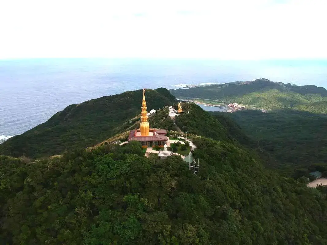
Lingjiushan Monastery is an impressive temple in the mountains of New Taipei on the Northeast coast. You can only get there by foot. There you can find some large golden statues and some great views of the surrounding coastline.
Background: The monastery was started by a former ROC soldier who fought against the PRC in Burma during the 1960s. He then retired near Shuangxi and started this monastery. His religion is now international, has raised tons of money, and also owns t Tours and Activities: You can purchase tours and tickets for many activities in Yilan such as Su'ao Crayon Castle, Taipingshan, Turtle Island, Lanyang Museum, Toucheng Leisure Farm, Zhang Mei Ama Capybura Farm, Bambi Land, Yinong Ranch, National Center for Traditional Arts, Taxi Museum, Glamping, Camping, ATV / 4-wheeling experience, SUP / paddle boarding, Ximeng Forest Theater, Surfing, Kayaking, Horse Riding, River Tracing, River Rafting, River Tubing, Pack Rafting, Water Biking, Snorkeling, Canoeing, Shrimping and many others through Klook here or KKday here. Hotels on Taiwan's Northern Coast: We recommend Fullon Hotel which has locations in Tamsui and Fulong near the beach (book on Booking.com here, Tripadvisor here, Agoda here, or Hotels.com here). We have also stayed at and recommend Hai Xia Your Home which is right in front of Fulong Beach (book on Booking.com here, Tripadvisor here, Agoda here, or Hotels.com here). Looking for a hotel? We recommend booking through Booking.com here, which provides the best quality selection of accommodation in Taiwan. Find out where to stay in our Taiwan hotels guide or search for the best hotel deals in Taiwan here. How to get there: By Train: Take the TRA train to Fulong Station. Walk straight from the station and you will see tons of bike rental shops. You can book tickets to travel to Yilan via inter-city bus on Klook here. You can book tickets to Yialn via high speed rail (HSR) on Klook here or KKDay here. Book tickets via the normal train (TRA) on Klook here. Bicycle rental: Cycling is the best way to enjoy Taiwan's landscapes if you have the time and energy. Looking for bicycle rentals in Taiwan? You can search on KKday here and search for tours on Klook here. You can also check out our Taiwan cycling guide here. By Car/Scooter: Take provincial highway 2 from Qidu in Keelung through the mountains past Shifen and Shuangxi until you reach Gongliao on the coast. The beach is right in front of the train station, and there is free parking in front of Dongxing Temple. From there you can walk to the train station where there are bike rentals everywhere. Looking for scooter rental in Yilan? You can search Klook here or KKday here to look for options. You can also check out our scooter rental guide here. If you are looking for car rentals in Yilan, you can also search Klook here or KKDay here. You can also check out our car rental guide here. Map: 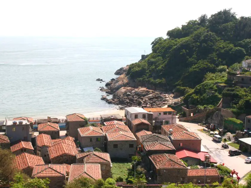
Nangan is the largest Island in the Matsu Archipelago. Besides being the main transportation hub to the other islands in Matsu, it also has traditional stone house villages, military museums, a giant statue of Mazu, a variety of local food, and much more to explore.
Background: Thousands of years ago, stone aged peoples once inhabited the Matsu Islands, including Beigan Island itself. These stone aged people later disappeared. The Matsu islands were inhabited again around the Song Dynasty (990 - 1200 AD) by Chinese Fisherman, the descendants of whom still inhabit the islands today. Because the Goddess Mazu's corpse washed ashore on this island, Nangan is also known as Matsu Island. During the Chinese Civil War, Matsu was used as a military outpost for the retreating ROC. During the years that followed, it withheld shelling and threats of invasion from China, helping to keep Taiwan free of communist control. In 1992 after cross straight relations had warmed up, martial law was lifted on the islands and tourists were allowed to visit. In the year 2000, a ferry link with Fuzhou started to provide constant China Mainland visitors to the island, as part of the three links with China. In 2003, the Nangan airport was completed, which made Nangan the true transportation hub of Matsu. Nangan has a population of 4,000 people, and is the largest island in Matsu in terms of population and geographical size. When to go: We recommend going between April and June when the "blue tear" phosphorescent microbes in the water will be the most visible at night. Also, winters can be cold and windy and summers very hot, and there could also be typhoons in the summer and fall. How to get there: By Boat: There are daily ferries from Taipei or Keelung that usually take an overnight trip to Nangan, passing through Dongyin Island. There are boats from Beigan Baisha Harbor (北竿白沙港) to Nangan Fu'Ao Harbor (南竿福奧港) every hour from 7 AM to 5 PM. You can book tickets between Nangan and Beigan Islands on KKday here. By Plane: There are flights to and from Taipei Songshan Airport three times a day via Uni Air. You can book flights on KKday here, Trip.com here, CheapO Air here, or Kiwi here. Price: By Boat: 500-2000 NT per person (one way from Taipei or Keelung). You can book ferry tickets to Matsu on KKday here. 160 NT per person (one way from Beigan). You can book tickets between Nangan and Beigan Islands on KKday here. By Plane: About 2000 NT (one way from Taipei). There are flights to and from Taipei Songshan Airport three times a day via Uni Air. You can book flights on KKday here, Trip.com here, CheapO Air here, or Kiwi here. Tours and Activities: Beihai Tunnel Rocking Boat: about 150 NT Blue Tears Museum: about 300 NT SUP/Paddle experience: about 2300 NT You can search for other tours and activities on KKday here or Klook here. Just to let you know, if you book using the links above, we get some commission at no cost to you, and you can help support our blog. You can click here to receive $5 USD on your first Klook purchase. Hotels: We have stayed at and recommend Fu Hwa Homestay on Nangan (you can book on Agoda here, Booking,com here, or Trip.com here), and B&B of Blueshine on Beigan (you can book on Agoda here, Booking,com here, or Trip.com here). Both places were excellent, and provided us a car ride to and from the airport for free. You can also check out our Taiwan hotels guide here. Looking for a hotel? We recommend booking through Agoda here, which provides the best quality selection of accommodation on the island. You can also book Wifi and SIM cards for Taiwan on Gigago here. Need travel insurance? Compare prices on Insubuy here. How to get around the island: Nangan is a large, hilly island and it would be very hard to get around on foot or bicycle. We recommend one of the following By Ferries: The only way to get to smaller islands without airports is by ferry. You can check KKday here for ferry tickets or buy them at the harbor. By Scooter: We recommend riding a scooter as your #1 choice. It's fast, convenient, and there isn't much traffic on the island. A scooter will cost about 500 NT per day to rent. You can rent a scooter on Klook here or KKday here. When braking on hills, use both brakes, otherwise, you could lose traction on one tire and skid. Don't stop or park on a slope. Also, some hills that are too steep are closed off for scooters. You can also check out our scooter rental guide here. By Car/Taxi: You can rent a car or hire a taxi for 200O NT per day. If you are looking for car rentals, you can also search Qeeq here, Klook here, or KKday here. You can also check out our car rental guide here. By Bus: There are buses that go around the islands, but wait times can be 30 minutes or more. By Bicycle: Cycling is the best way to enjoy Taiwan's landscapes if you have the time and energy. Looking for bicycle rentals in Taiwan? You can search on KKday here and search for tours on Klook here. You can also check out our Taiwan cycling guide here. Map: Please see below: 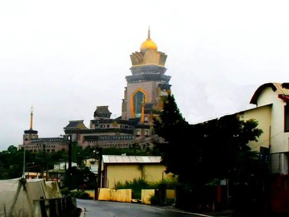
The Chung Tai Shan Monastery in Puli, Nantou County (aka Chung Tai Chan Buddhist Temple) is a large monastery, built by the same architect that built the Taipei 101. The building features a full size wooden pagoda inside the main tower, as well as a Buddhism museum. It is the tallest Buddhist Monastery in the world.
Background: The Chungtai Shan Buddhist Temple is a large complex built as the headquarters for the Chung Tai Shan Buddhist Monastic Order. The Monastic Order was founded in 1987 by Master Wei Chueh. Now the order has branches all over the world. The monastery itself was completed in 2001, and is 136 meters tall. The chief architect behind the building was Chu-Yuan Lee, the same architect that built the Taipei 101. It is the tallest Buddhist Monastery in the world, and the second largest in Taiwan behind Foguangshan. Hours: 8 AM to 5:00 PM every day Price: Free Tours: There are many tours and activities available in Nantou such as river Tracing, paragliding, Shanlinxi Forest Recreation Area 杉林溪, Cona's Chocolate Castle, Shuiyuan Suspension Bridge, JOJOZOO Park, and Aowanda Forest Recreation Area. You can find more tours of Nantou on Klook here or KKday here. Accommodation: We have stayed at and recommend Jenq Yang Hotspring Hotel (you can book on Agoda here, Booking.com here, Trip.com here, or Klook here), a hot spring hotel near the mystical Lushan hot spring, and Maple Leaf Holiday Villa (you can book on Agoda here, Booking.com here, Hotels.com here, Expedia.com here, Trip.com here, or Klook here), a lodge with a great view and within walking distance of Cingjing Farm. I also have stayed at and recommend Kirin Villa (you can book on Agoda here or Booking.com here), a mountain resort in Puli near Sun Moon Lake. Looking for a hotel? Find out where to stay in our Taiwan hotels guide or search for the best hotel deals in Taiwan here. We recommend booking through Agoda here, which provides the best quality selection of accommodation on the islands. You can also book Wifi and SIM cards for Taiwan on Gigago here. Just to let you know, if you book using the links above, we get some commission at no cost to you, and you can help support our blog. You can click here to receive $5 USD on your first Klook purchase. How to get there: Car/Scooter: Take County Road 78 out of Puli (Shoucheng Raod) and continue north until you see the large monastery. It is hard to miss. There is free parking near the monastery. Looking for scooter rental in Nantou? Search Klook here or KKday here to search for options. You can also check out our scooter rental guide here. If you are looking for car rentals, you can also search Qeeq here, Klook here, KKday here. You can also check out our car rental guide here. Bus: Take an intercity bus from Taichung to Puli Bus Station. From there, take Nantou Bus 6651C to Chung Tai Monestary Station. You can book tickets to travel to Nantou via inter-city bus on Klook here. You can book tickets to Taichung via high speed rail (HSR) on Klook here or KKDay here, or book tickets via the normal train (TRA) on Klook here, then switch to a bus to Nantou. Bicycle Rental: Cycling is the best way to enjoy Taiwan's landscapes if you have the time and energy. Looking for bicycle rentals in Taiwan? You can search on KKday here and search for tours on Klook here. You can also check out our Taiwan cycling guide here. Map: Please see below: 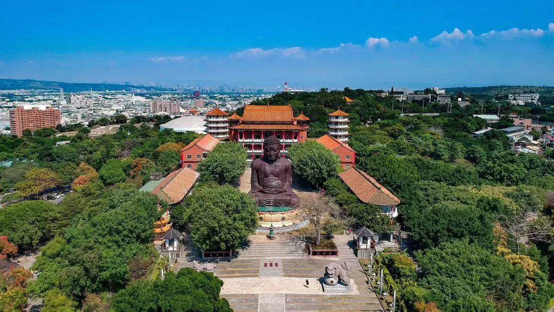
Baguanshan is perhaps the most famous religious site in Changhua, and has the best views of the city and the surrounding area. It is also known for its large buddha statue and viewing platform. There are also hiking trails and historical sights nearby. It is definitely worth a visit on your next trip to Changhua.
Background: Baguashan can literally be called "Eight Trigram Mountain" because Bagua means eight triangles placed together, which is said to ward off evil in Buddhism and Daoism. The mountain was named as a key battleground during the Lin Shuangwen Rebellion, in which a clan of Hakka people rebelled and was crushed by the Qing Dynasty. Later during the Japanese occupation of Taiwan, the mountain was used as a military base. During the ROC era, local resident Lin Qingyao built a temple here and a giant Buddha in 1956. A veteran's memorial martyr's shrine was also built by the ROC on the mountain. The mountain itself is only 97 meters above sea level but still provides great views because it is surrounded by flat land. The mountain is slowly rising and in millions of years will create a mountain chain. Price: Free Accommodation: We have stayed at and recommend Guide Hotel Changhua Jhongjheng, which is one of our favorite hotels in all of Taiwan, with great quality and service right in downtown Changhua. (book on Agoda here, Booking.com here, Hotels.com here, Expedia here, or Trip.com here) Looking for a hotel? We recommend booking through Agoda here, which provides the best quality selection of accommodation on the islands. Find out where to stay in our Taiwan hotels guide or search for the best hotel deals in Taiwan here. You can also book Wifi and SIM cards for Taiwan on Gigago here. Need travel insurance? Compare prices on Insubuy here. Tours: Tours and activities in Changhua include Magical Mushrooms Leisure Farm, Cheng Mei Cultural Park, Changhua Love Farm, Gushengwu Paleontology Park, Taiwan You Good School of Cookie, Baiguoshan Amusement Park, Yunhe Starry Sky View Restaruant , Tianzhong, Yakuta Experience , Qingshui Hot Spring Glamping, Fruit Picking , Tonight Star Leisure Farm, Tianweiwang Scenic Spot, and more. You can find more tours of Changhua on Klook here or KKday here. Just to let you know, if you book using the links above, we get some commission at no cost to you, and you can help support our blog. You can click here to receive $5 USD on your first Klook purchase. How to get there: By car/scooter: Take provincial highway 1 to the foot of the mountain, then turn up. There is limited parking on the side of the road and two paid parking lots which can get full on weekends. If you are looking for car rentals, you can also search Qeeq here, Klook here, or KKday here. You can also check out our car rental guide here. Looking for scooter rental in Changhua? Check out Klook here or KKday here to search for options. You can also check out our scooter rental guide here. By Train: The mountain is within ten minutes' walking distance from Changhua TRA station. You can book tickets to travel to Changhua via inter-city bus on Klook here. You can book tickets to Changhua via high speed rail (HSR) on Klook here or KKDay here. Book tickets via the normal train (TRA) on Klook here. By Bicycle: Cycling is the best way to enjoy Taiwan's landscapes if you have the time and energy. Looking for bicycle rentals in Taiwan? You can search on KKday here and search for tours on Klook here. You can also check out our Taiwan cycling guide here. Map: See below: 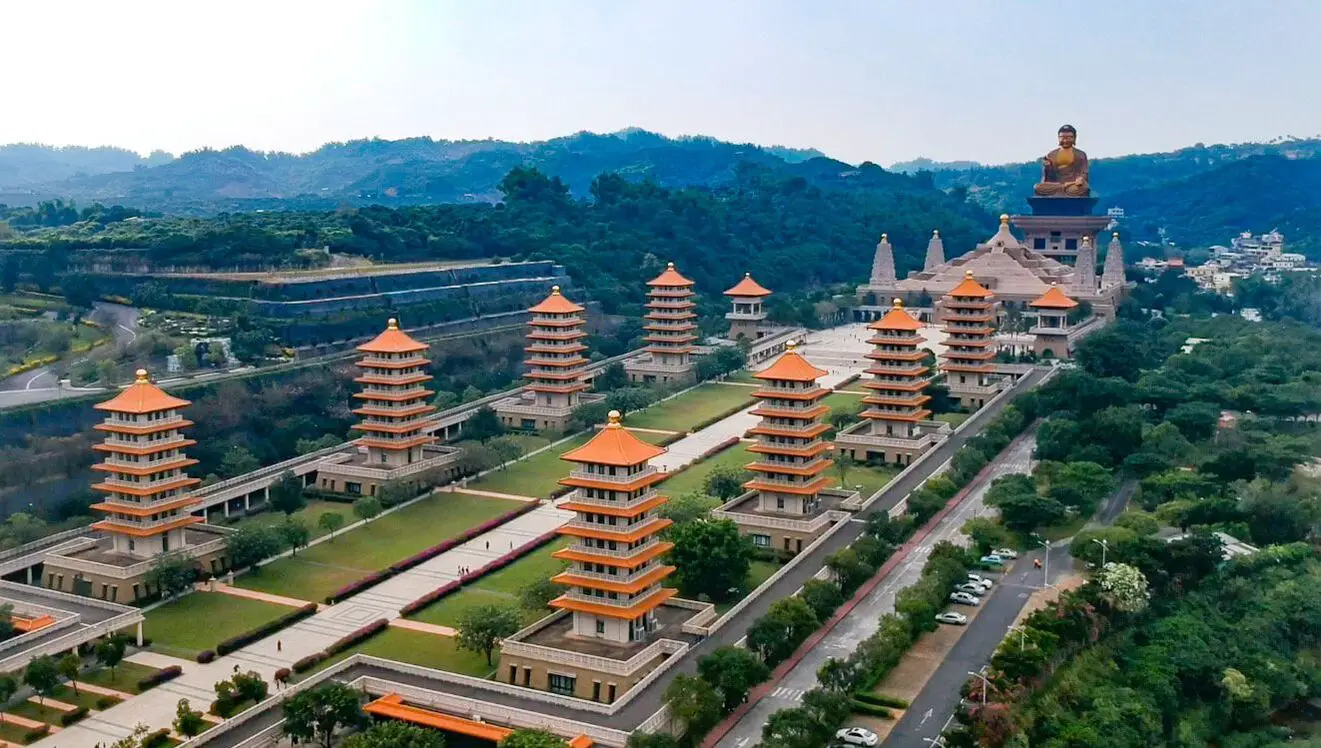
Fo Guang Shan (aka Buddah Light Mountain, Buddah's Light Mountain, or Buddha Memorial Center) is a Buddhist sect based in Dashu District of Kaohsiung. The headquarters in Dashu feature the largest Buddhist monastery in the country along with a 8 pagodas, a large pyramid-shaped stupa, huge sitting Buddha statue, and Buddha museum. The massive complex can fill a tourists itinerary for more than a day, and is TripAdvisor's top ten tourist landmarks in Taiwan.
Background: The Fo Guang Shan religion was established by Hsing Yun in 1967, begning with the development of the monastery in Dashu. The religion is focused on Humanistic Buddhism, with an emphasis on technology. Fo Guang Shan has since grown to be one of the largest charitable organizations in Taiwan. Currently it has established medical programs, several colleges, one university, and has presence in 173 countries. The Fo Guang Shan Buddha Museum started construction in 2008 and was completed in 2011. One of the most precious artifacts in the museum is the tooth of Sakyamuni Buddha. The grounds feature eight pagodas, hundreds of statues, 4 different museums, an auditorium, Jade and Golden Buddha Statues, and 48 underground palaces (time capsules). Price: Free Hours: 9 AM to 8 PM How to get there: From Kaohsiung, take provincial highway 29 north to Dashu, and it will be right in front of the National Highway 3 bridge. You can also travel there via public buses. Looking for scooter rental in Kaohsiung? You can check out Klook here or KKday here to search for options. You can check also out our scooter rental guide here. If you are looking for car rentals, you can search Qeeq here, KKday here, or Klook here. You can also check out our car rental guide here. You can also book a Kaohsiung Travel pass here. Accommodation We have stayed at and recommend Chao She Hotel (you can book on Agoda here, Booking.com here, Hotels.com here, or Expedia here) IHI Sanduo Travel Hotel (you can book on Agoda here, Booking.com here, Hotels.com here, or Expedia here), and Mingli Hotel (you can book on Agoda here, Klook here, or Hotels.com here) which are three inexpensive and high quality choices in downtown Kaohsiung. I also have stayed at and recommend Kaohsiung Meinong Rabbit Paul Homestay B&B (you can book on Agoda here, Booking.com here, or Trip.com here), a quiet B&B in rural Meinong, and Chengching Lakeside Resort (you can book on Agoda here, Booking.com or Trip.com here)and the Grand Hotel Kaohsiung (you can book on Agoda here, Booking.com here, Hotels.com here, or Expedia here) which both offer breakfast buffet and free entrance into Chenqing Lake Park. I have also stayed at the 85 sky tower which offers great views of the city; you can search for rooms in the 85 sky tower on Agoda here, Booking.com here, Hotels.com here, Expedia here, or Trip.com here). Find out more about where to stay in our Taiwan hotels guide or search for the best hotel deals in Taiwan here. We recommend booking through Agoda here, which provides the best quality selection of accommodation on the islands. You can also book Wifi and SIM cards for Taiwan on Gigago here. Need travel insurance? Compare prices on Insubuy here. Tours: You can find more tours and activities in Kaohsiung such as Pier 2, Meinong Hakka Museum, Hamasen Railway Museum, Suzuka Circuit Park, i-Ride Kaohsiung Visual 5D Flying Theater, National Science and Technology Museum , Senya Village Restaruant, Austin Land, Ski School Indoor Ski Slope, and many more on Klook here or KKday here. Just to let you know, if you book using the links above, we get some commission at no cost to you, and you can help support our blog. You can click here to receive $5 USD on your first Klook purchase. Map: Please see below: 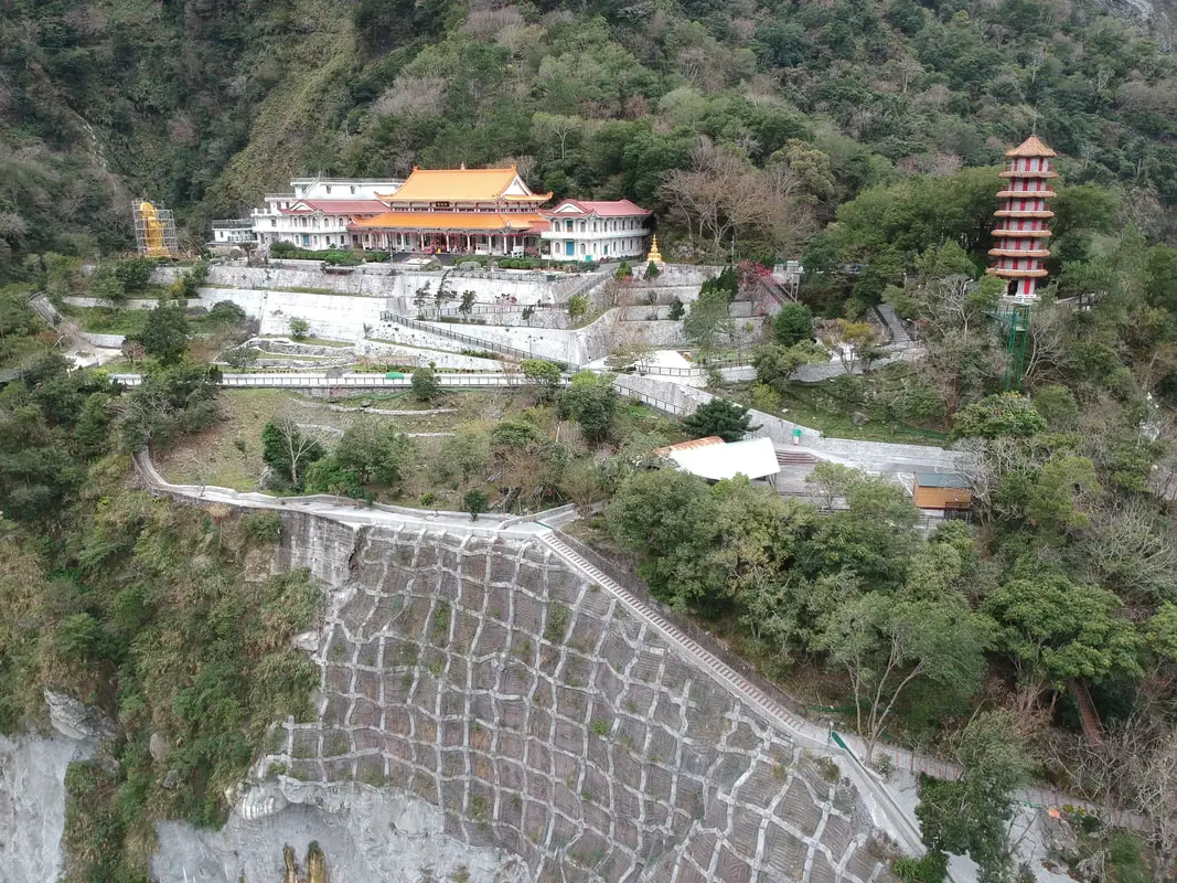
Tianxiang Recreation Area features the widest and most flat terraces within Taroko Gorge. Here you can find Xiangde Temple, Tianfeng Pagoda, Pudu Suspension Bridge, and Silks Place Taroko, which are all surrounded by amazing high canyons and beautiful deep river ravines. It is a must see spot inside Taroko Gorge.
Background: Taroko National Park is well known for its marble cliffs and canyons, and is also known as "The Marble Gorge." Millions of years ago, the rock we see today was sediment at the bottom of the Pacific Ocean, but oceanic and tectonic pressure turned it into limestone, and later into marble. Later the Eurasian plate was uplifted where Taiwan is today, and a gorge was cut out of the limestone thanks to the Liwu River. Taroko means "human being," from the Truku tribal language. Originally the Tupido Tribe settled in the area of what is now Tianxiang Taiti mesa. They built the Tupido Tribe Trail which was only 30 cm wide, and resided there until they were massacred by the Japanese in 1914. In 1917, the Japanese expanded the original trail made by the Tupido Tribe to 1.5 M and forced aboriginal tribesmen to carry goods along the trail to the east coast. This is now the Zhuilu Old Trail. Currently only 3km of the trail is open to the public. The Japanese created a national park in the Area in 1937, which was disestablished by the ROC in 1945, and then reenstated in as a national park in 1986. Tianxiang lies 455 meters above seas level, and lies at the convergence of the Dasha River and the Tazijili River, forming the Liwu River. Xiangde Temple was built in 1966 shortly after the central cross island highway was finished. It is a Buddhist monetary, and the area was chosen for it's quiet beauty. How to get there: By Car: From Taipei, Take National Highway 5 to Yilan and then drive on the Suhua Highway 9 to Hualien. A few miles before Hualien City, the gorge will be on your right. Tianxiang is 18 KM in. Looking for a scooter rental in Hualien? You can search KKday here or Klook here to look for options. You can also check out our scooter rental guide here. If you are looking for car rentals in Hualien, you can also search Klook here or KKDay here. You can also check out our car rental guide here. By Train: Take the train to Hualien station, and from there you can rent a scooter or car, or take a tour bus to the gorge, and then get off at Tianxiang. You can book tickets to travel to Hualien via inter-city bus on Klook here. Book tickets via the normal train (TRA) on Klook here. For more travel information see here. Where to stay? Most of the accommodation you will find is near the city center. If you only want to visit Hualien City and Taroko Gorge, you can consider booking a hotel near downtown, walking or cycling around the city, and taking a bus to Taroko Gorge. We have stayed at and recommend Dream Taiwan Homestay (Agoda / Booking.com / Expedia / Hotels.com), a high quality hostel for the money in downtown Hualien, Farglory Hotel (Agoda / Booking.com / Expedia / Hotels.com), right next to Farglory Ocean Park with amazing views of Hualien, and Goldenflower B&B (Agoda / Booking.com) in Yuli right next to Sixty Stone Mountain. You can find out where to stay in our Taiwan hotels guide or search for the best hotel deals in Taiwan here. You can also book Wifi and SIM cards for Taiwan on Gigago here. Need travel insurance? Compare prices on Insubuy here. Tours: You can find tours of Tianxiang on Klook here or KKday here. You can find more tours and activities in Hualien such as Surfing, Paragliding, SUP / Paddle Boarding, Kayaking, Canoeing, River Tracing, and much more on Klook here or KKday here. Hours: 24/7 Flying a Drone? Apply for a drone permit here. Price: Free! Map: Please see below: 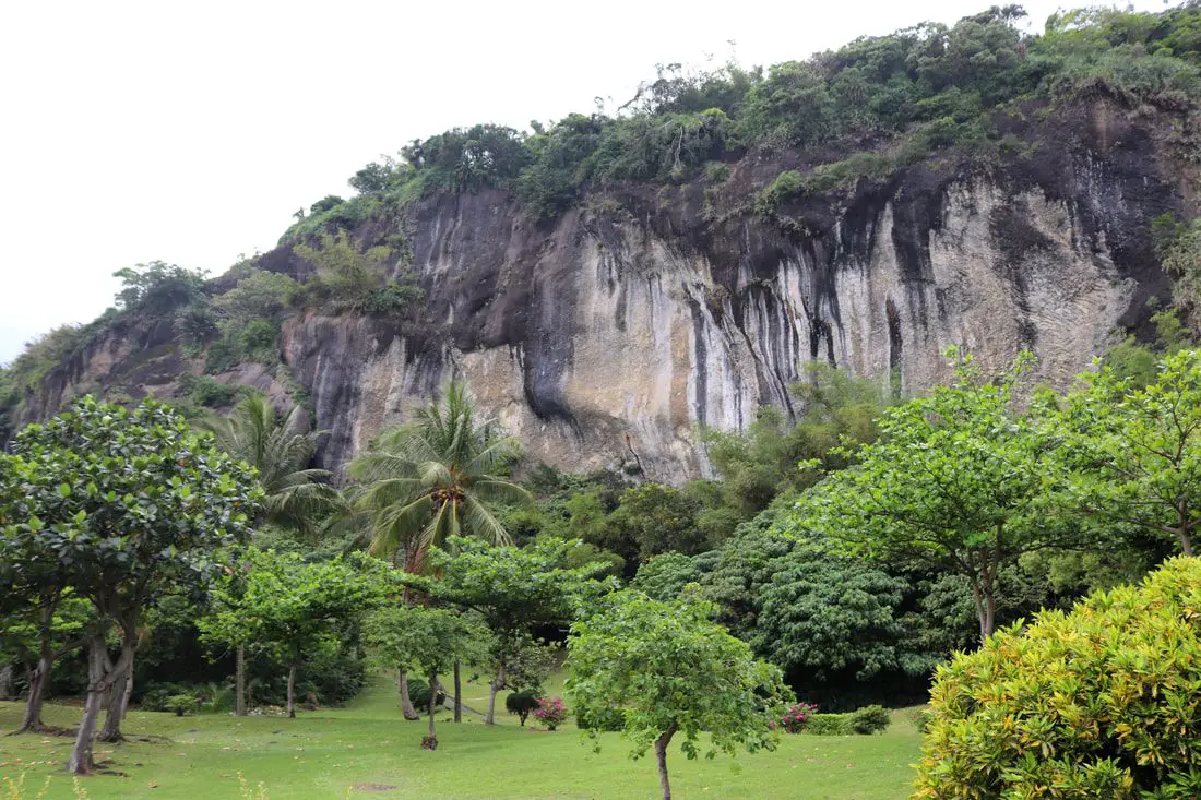
The Baxian Caves (aka Baxiandong) on the east coast in Taitung County have the earliest evidence of humans living in Taiwan, including stone tools dating back to over 30,000 years ago. In recent times the caves were converted into Taiwan folk religion temples, but now all of the 30 caves in the area have been reclaimed by the government to preserve this important archaeological site. The area is now open to the public, and there are trails and a large park in front of the caves.
Background: The Baxian Caves were originally underwater until geological forces between the Philippine and Eurasian tectonic plates forced the ground upward. The first traces of people living here date back to 30,000 years ago during the late Paleolithic age. They were thought to have crossed a land bridge between what is now Fujian Province of China and Taiwan, and created what is known as the Changbin Culture, and stayed here until about 1500 years ago during the late stone age. After that, their culture mysteriously disappeared. The people that lived in the caves were mostly hunter-gatherers that used stone tools, and used the caves as shelter. Later the area was inhabited by the Amis Aboriginie Tribe (阿美族) who have lived there since at least 1500 BC, and called the area Lohan, which means caves. After the area was settled by Han Chinese farmers, there arose a legend that the caves were home to the eight immortals (八仙 Baxian), from where the caves now get their name and many temples were built in the caves here, as well as to other gods such as the Earth God, Buddha, Guanyin, and others. Price: Free Parking: 60 NT for cars, 20 NT for scooters. You can book a tour to Taitung with Klook here or KKday here. Hours: 8:30 AM PM every day. How to get there: By Car/Scooter: We recommend taking Provincial Highway 11 from Taitung north 30km to the caves. Feel free to stop and enjoy the scenery along the way. You can also try to coming south down from Hualien. Looking for scooter rental in Taitung? You can search Klook here or KKday here to search for options. You can also check out our scooter rental guide here. If you are looking for car rentals, you can also search KKday here or Klook here. You can check out our car rental guide here. By Bus: You can take bus 8102 or 8103 from Taitung, but according to Google this will take about 3 hours. You can also try to coming south down from Hualien. You can book tickets to travel to Taitung via inter-city bus on Klook here. Book tickets via the normal train (TRA) on Klook here. Accommodation: Booking accommodation in the Taitung can be difficult in the summer months and on weekends when rooms can be fully booked for months in advance. We suggest a better quality selection on Agoda.com. We have stayed at and recommend the Papago International Resort in Chishang (you can book on Agoda here, Booking.com here, Hotels.com here, or Expedia here), which is a five star hotel with private villas with pools for each room, and Mountain and Ocean B & B in Taimali (you can book on Agoda here, Booking.com here, Hotels.com here, or Expedia here), which is a quiet and affordable B&B right next to the beach. You can also book Wifi and SIM cards for Taiwan on Gigago here. Need travel insurance? Compare prices on Insubuy here. Tours: There are many tours and activities such as snorkeling, diving, SUPing, Surfing, Speed Boating, Glamping, River tracing and more in Taitung. You can find more tours of Taitung on Klook here or KKday here. Just to let you know, if you book using the links above, we get some commission at no cost to you, and you can help support our blog. You can click here to receive $5 USD on your first Klook purchase. Map: Please see the map below: 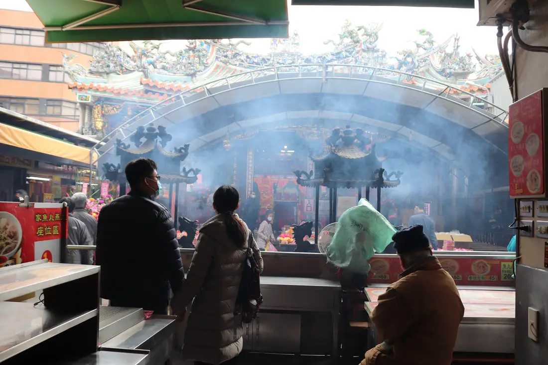
Hsinchu City God Temple, or Chenghuang Temple, dates back to the Kingdom of Tungming and was built in the middle of the old bamboo-walled city of Zhuqian. Currently, it is the religious center of the city and also has its own night market. It is one of the most impressive historical sites in Hsinchu and is worth a visit for anyone in the area.
Background: After the settlement of the area by Han Chinese farmers in about 1711 during the Kingdom of Tungming, what was then known as Zhuqianshe became the most important economic area in northern Taiwan. By 1723, a walled city was built here out of bamboo, because brick walls were forbidden for fear of a revolt against the Qing authorities. The name Zhuqiancheng (竹塹城) literally means bamboo moat city. The bamboo-walled city had four gates and its perimeter was about 1.4 KM long. In 1806, the city was upgraded with earthen walls. In 1748, the Chenghuang City God temple was completed, being built in the center of the city. The temple was refurbished and restored in 1792, 1799, and 1924. In 1891, the Guangxu Emporer visited Taiwan and held a prayer meeting here. He left a plaque that still stands today which reads "Golden Gate Protection (金門保障)," which is meant that the temple would provide protection to the entire island of Taiwan. The temple also features six different halls. Parades and activities are held regularly at the temple. There is also a night market that surrounds the temple known as the Chenghuang Temple Night Market (新竹市城隍廟夜市). Hours: 24/7, but I recommend visiting at night when the night market is open. Price: Free Tours: You can find more tours and activities in Hsinchu such as You can find more tours and activities in Hsinchu such as river tracing, wild hot springs, white water kayaking, backpack rafting, Little Ding Dong Theme Park, Leofoo Village Theme Park, Window on China Theme Park, glamping, camping, stone spa, horse riding, Yukids Island, Tom and Bei Bei Parent Child Paradise, bee keeping experience, cycling, dried persimmons experience, Jump Wave Trampoline Park and more on Klook here or KKday here. Where to stay: Most of the accommodation you will find is near the city center. If you will only visit downtown, you can consider a day trip from Taipei. We have stayed at and recommend the Golden Motel a high quality motel near Green Grass Lake (you can book on Agoda here, Booking.com here, Hotels.com here, Expedia here, or Trip.com here), and CD Motel, another high quality motel in downtown Hsinchu (you can book on Agoda here, Booking.com here, or Trip.com here). Unfortunately I cannot recommend any further hotels that I have stayed at in Hsinchu because usually we stay at my wife's uncle's house. You can find out where to stay in our Taiwan hotels guide or search for the best hotel deals in Taiwan here. You can also book Wifi and SIM cards for Taiwan on Gigago here. Need travel insurance? Compare prices on Insubuy here. Just to let you know, if you book using the links above, we get some commission at no cost to you, and you can help support our blog. You can click here to receive $5 USD on your first Klook purchase. How to get there: The temple is within walking distance of Hsinchu TRA station. ou can book tickets to travel to Hsinchu via inter-city bus on Klook here. You can book tickets to Hsinchu via high speed rail (HSR) on Klook here or KKDay here. Book tickets via the normal train (TRA) on Klook here. By Bicycle: Cycling is the best way to enjoy Taiwan's landscapes if you have the time and energy. Looking for bicycle rentals in Taiwan? You can search on KKday here and Klook here. You can also check out our Taiwan cycling guide here. If you are looking for car rentals in Hsinchu, you can also search Qeeq here, Klook here, or KKDay here. You can also check out our car rental guide here. Looking for scooter rental in Hsinchu? You can search Klook here or KKday here to look for options. You can also check out our scooter rental guide here. Map: Please see below: 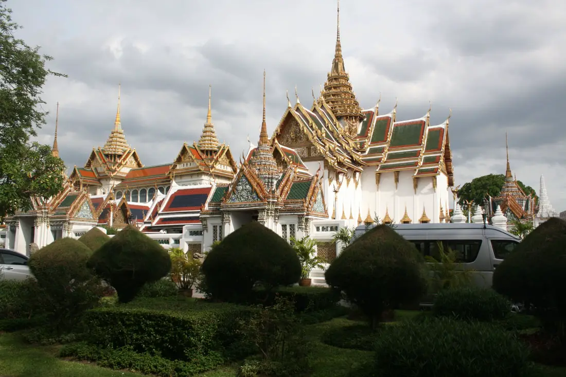
Bangkok, the capital of Thailand, is a bustling city with vibrant street life, delicious food, amazing temples, and the grand palace. Here in this blog I will take you on our four day three night journey to Bangkok.
Before the Pandemic began, I had planned a trip to Thailand for the summer of 2020. Obviously that didn't happen, and to console myself here is a blog detailing our trip to Bangkok and Ayutthaya. Background: Bangkok is the most populous city in Thailand with over 10 million residents, and is also the nation's capitol. During the Ayutthaya Kingdom, it was merely a small trading post. In the late 1700s, it was named the capital of Siam (as Thonburi and Rattanakosin). The city has been the center of modernization in the country, and the heart of the government, which is ruled by constitution but also includes monarchy and has undergone numerous military coups. Currently, democratic rights are being contested by young people who feel they do not have a voice in the government. Ayutthaya Historical Park is an old capital of Thailand (Ayutthaya Kingdom), and was the capital of Thailand for the longest period of time from around 1351 to 1767 when it was destroyed by the Burmese, ending the empire. Here is a map of Bangkok Below: |
Author 作家I am an American expat who has extensive experience living, working, and traveling in Taiwan. In my day, I had to learn many things about Taiwan the hard way. But I have come to learn that Taiwan is one of the best places in the world for Foreigners to live. This blog does not represent the opinions of every foreigner in Taiwan. I am just trying to help others learn more about this beautiful country. Categories
|
 RSS Feed
