

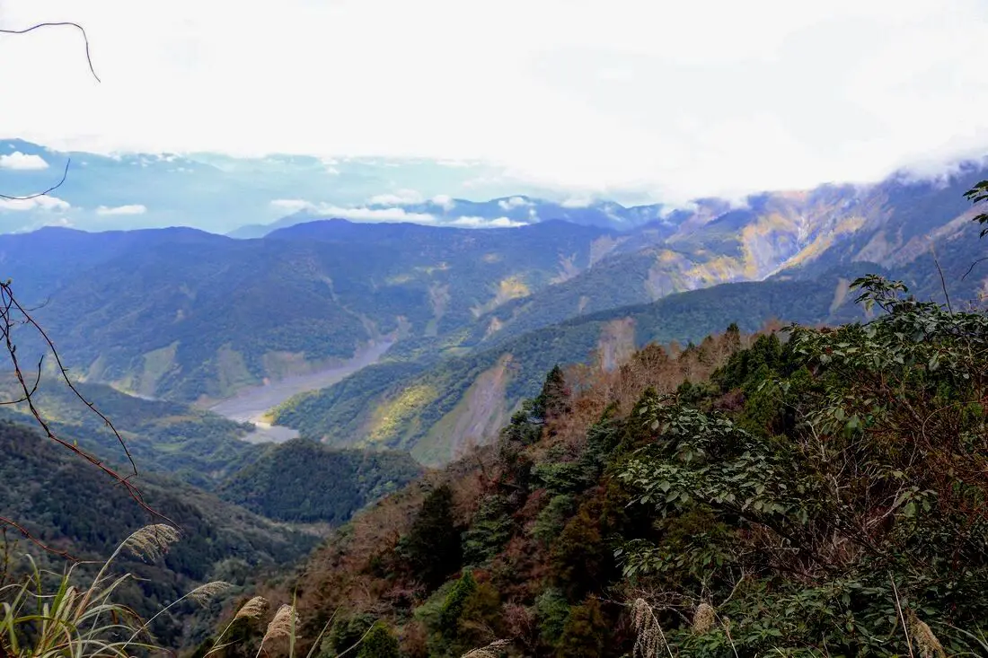
Taipingshan (aka Taipingshan National Forest Recreational Area 太平山國家森林游樂區) is a magical mountain paradise in Datong Township of Yilan County in Taiwan. It has an old Japanese era logging railroad track which has mostly been abandoned, but part of it has been restored with a working train. In addition there are hot springs, Taiwan's largest alpine lake, hikes, wildlife, and endless mountain scenery to explore.
Background: In 1906, the Japanese Indigenous affairs police officers sent a team of men to Fanfan Mountain, where they discovered huge ancient cypress trees. Later the Japanese renamed the area Taipingshan, and began logging the mountain in 1915. The Taipingshan Forest Railway was completed in 1934 and had at least 12 stations, with the grade up the mountain ranging from 2-3%. Loggers relied heavily on wires and pulley systems to haul logs to the railway, which differentiates it from the Alishan Railway. Because of the extensive use of wires or iron donkeys, it was difficult to convert the entire railway to a tourist railway, therefore only a short section at Maosing remains for tourists. The logging industry continued in Taiwan until it was banned in the 1980s, after which the area was converted into a forest recreation area in 1983 and opened to the public. The mountains in Taipingshan range from 500 to 2000 meters high, and is part of the northern central mountain range. The highest peak here is Nanhu Mountain at 3,740 meters high. The terrain generally consists of high mountains and deep valleys, which have been pushed up by the convergence of the Eurasian and Philippine plates, and eroded by torrential rains. Taipingshan is 12,929 hectares, and includes six major areas: Tuchang, Jioujhihze, Jhongjian, Taipingshan, Maosing and Cueifong Lake. Taipingshan holds the record for 24 hour rainfall in Taiwan of 1015 mm, recorded in 2016 during Typhoon Megi. The area is also one of the most accessible places in Taiwan to see snow during winter. The forest recreation area is now a popular place for nature enthusiasts and hikers, and is one of the top three most popular forest recreation areas in Taiwan. Hours: 6 AM to 8 PM (open 4 AM on weekends) Price: 150 NT for non-holidays, 200 NT for holidays Cars: 100 NT Scooters: 20 NT Jioujhize Hot Springs: 250 NT in winter and 150 NT in summer Bong Bong Train: 180 NT You can buy a discount entrance ticket to Taipingshan on KKday here or book a tour on Klook here. Website: https://tps.forest.gov.tw/ Tours and Activities: You can purchase tours and tickets for many activities in Yilan such as Su'ao Crayon Castle, Turtle Island, Lanyang Museum, Toucheng Leisure Farm, Zhang Mei Ama Capybura Farm, Bambi Land, Yinong Ranch, National Center for Traditional Arts, Taxi Museum, Glamping, Camping, ATV / 4-wheeling experience, SUP / paddle boarding, Ximeng Forest Theater, Surfing, Kayaking, Horse Riding, River Tracing, River Rafting, River Tubing, Pack Rafting, Water Biking, Snorkeling, Canoeing, Shrimping and many others through Klook here or KKday here. Accommodation: Looking for a hotel? We recommend booking through Agoda here, which provides the best quality selection of accommodation on the islands. We have stayed at and recommend Ying Shih Guest House, a resort in Datong Township near Taipingshan and Fan Fan Hot Spring (you can book on Agoda here or Booking.com here), and Jiaosi Hotspring Hotel, a hotel with hot springs in each room (you can book on Agoda here, Booking.com here, Hotels.com here, Expedia here, or Trip.com here). We have also stayed at Toucheng Leisure Farm, a recreational farm and experience center in Toucheng (you can book on Agoda here, Booking.com here, Hotels.com here, Expedia here, on Klook here, or on Trip.com here). You can also book Wifi and SIM cards for Taiwan on Gigago here. Need travel insurance? Compare prices on Insubuy here. Just to let you know, if you book using the links above, we get some commission at no cost to you, and you can help support our blog. You can click here to receive $5 USD on your first Klook purchase. How to get there: By Bus: Kuo-kuang departs from Yiland and Luodong at 7:40 and 8 AM, and arrives at Taipingshan at 10:30 AM. The bus then departs Taipingshan at 2:30 PM. You can book tickets to travel to Yilan via inter-city bus on Klook here. You can book tickets to Yialn via high speed rail (HSR) on Klook here or KKDay here. Book tickets via the normal train (TRA) on Klook here. Bicycle rental: Cycling is the best way to enjoy Taiwan's landscapes if you have the time and energy. Looking for bicycle rentals in Taiwan? You can search on KKday here and search for tours on Klook here. You can also check out our Taiwan cycling guide here. By Car/Scooter: From Taipei, take National Freeway 5 to Yilan, then turn southwest on provincial highway 7 until you reach the turnoff to Taipingshan via Yijhuan Route 1. Looking for scooter rental in Yilan? You can search Klook here or KKday here to look for options. You can also check out our scooter rental guide here. If you are looking for car rentals in Yilan, you can also search Klook here or KKDay here. You can also check out our car rental guide here. Map: Please see below of the places covered in this blog:
0 Comments
Maolin District of Kaohsiung City is an amazing outdoor paradise and my favorite place in Taiwan. In this mountainous district of Kaohsiung, you can find waterfalls, streams, hot springs, butterflies, aboriginal culture, and great views, all by the roadside! Popular activities include swimming, hot spring bathing, river tracing, camping, and hiking.
Please note I have also finished blogs about Maolin Village, Wanshan Village, Duona Suspension Bridge, and Duona Village (click the links to see each individual blog). Background: During the Japanese occupation, some of the original inhabitants of Maolin Village live in the mountains behind Wanshan Village. However later these aboriginals were forcibly moved to the current village. Many of the inhabitants were originally located elsewhere, but had to relocate their home or village due to typhoons or unsafe terrain. There are a few abandoned villages above the current village that you can still hike to. The villages have about 2000 total inhabitants, mostly aboriginals from the Rukai (魯凱族) Wulu Bunun (布農) and Paiwan (排灣) tribes, as well as some Han Chinese people. The district also has Maolin Middle school, the only middle school, and three elementary schools. Wanshan has the smallest population of any village in Taiwan according to the government website here, with a population of just 450 people. 95% of the people are aborigines from the Rukai Tribe (魯凱族), and the rest are either from the Wulu Bunun Tribe (布農) or Han Chinese. Originally the people of Wanshan village lived at the base of Mali Mountain (麻里山), but were moved by the government in 1956 to their current location. Many of the inhabitants of Maolin were originally located elsewhere, but had to relocate their home or village due to typhoons or unsafe terrain. There are a few abandoned villages around Maolin that you can still hike to. Typhoon Morakot brought record floods to Taiwan because it slowly moved over the island delivering torrential rain. Nearly 700 people were killed during the disaster (to see what Maolin looked like right after the flooding, check out this blog here). Basically all the bridges in Maolin were destroyed during Typhoon Morakot in 2009 except Duona Suspension bridge which is built so high that it would never be affected by floodwater. Most all the bridges currently in Maolin were reconstructed after the 2009 floods. Duona is the most remote village in Maolin District of Kaohsiung City, and is said to harbor the most complete version of the Rukai Aborigine culture. The Rukai People first began to move into the area now known as Duona about 300 years ago (1700s), making it one of the oldest aborigine villages in Taiwan. Most of the people live in traditional stone houses made from nearby plentiful shale rock, which are characteristic of the Rukai Tribe. The stone houses are warm in the winter and stay cool during the summer. Near the village is a small plain which is said to be the home of Taiwan's indigenous species of black rice. The village was almost completely cut off from the outside world until the Japanese built the Duona Suspension Bridge, which helped to link it to the rest of Taiwan as well as better control the native population. The actual Distrcit boundaries extend to Pingtung County and Taitung County, and include largely untouched and "virgin" forests and mountain wilderness areas such as Shuang-guei Lake, providing precious wildlife habitat for many of Taiwan's indigenous animals and plants. Price: Free Hours: 24/7 When to go: I recommend going in the summer time when the waterfalls have plenty of water and warm temperatures make it a great time to go swimming. In winter it will be cold and the waterfalls can dry up. On the other hand if you want to go just for hiking, winter would be a better time to go. If there is a Typhoon, the inhabitants of Maolin will be evacuated, and you should not try to go in for your own safety. If you are coming to see butterflies, the butterfly migration is in the fall and ends roughly in November. How to get there: By Car: Maolin can be reached via provincial highway 27 from Pingtung or Liugui. Once you come to Dajin Bridge, go straight up the mountain. Looking for scooter rental in Kaohsiung? You can check out Klook here or KKday here to search for options. You can check also out our scooter rental guide here. If you are looking for car rentals, you can search Qeeq here, KKday here, or Klook here. You can also check out our car rental guide here. By Bus: You can take a bus there but I don't recommend it. It's a 3 hour bus ride from Pingtung Bus Station. If you can rent a car or scooter it is about a 1 1/2 hour drive from Kaohsiung. You can book tickets to travel to Kaohsiung via inter-city bus on Klook here. You can book tickets to Kaohsiung via high speed rail (HSR) on Klook here or KKDay here. Book tickets via the normal train (TRA) on Klook here. You can also book a Kaohsiung Travel pass here. Accommodation We have stayed at and recommend Chao She Hotel (you can book on Agoda here, Booking.com here, Hotels.com here, or Expedia here) IHI Sanduo Travel Hotel (you can book on Agoda here, Booking.com here, Hotels.com here, or Expedia here), and Mingli Hotel (you can book on Agoda here, Klook here, or Hotels.com here) which are three inexpensive and high quality choices in downtown Kaohsiung. I also have stayed at and recommend Kaohsiung Meinong Rabbit Paul Homestay B&B (you can book on Agoda here, Booking.com here, or Trip.com here), a quiet B&B in rural Meinong, and Chengching Lakeside Resort (you can book on Agoda here, Booking.com or Trip.com here)and the Grand Hotel Kaohsiung (you can book on Agoda here, Booking.com here, Hotels.com here, or Expedia here) which both offer breakfast buffet and free entrance into Chenqing Lake Park. I have also stayed at the 85 sky tower which offers great views of the city; you can search for rooms in the 85 sky tower on Agoda here, Booking.com here, Hotels.com here, Expedia here, or Trip.com here). Find out more about where to stay in our Taiwan hotels guide or search for the best hotel deals in Taiwan here. We recommend booking through Agoda here, which provides the best quality selection of accommodation on the islands. You can also book Wifi and SIM cards for Taiwan on Gigago here. Need travel insurance? Compare prices on Insubuy here. Tours: You can find more tours and activities in Kaohsiung such as Pier 2, Meinong Hakka Museum, Hamasen Railway Museum, Suzuka Circuit Park, i-Ride Kaohsiung Visual 5D Flying Theater, National Science and Technology Museum , Senya Village Restaruant, Austin Land, Ski School Indoor Ski Slope, and many more on Klook here or KKday here. Just to let you know, if you book using the links above, we get some commission at no cost to you, and you can help support our blog. You can click here to receive $5 USD on your first Klook purchase. Map: Please see a map below marked with all the destinations we will visit in this blog: 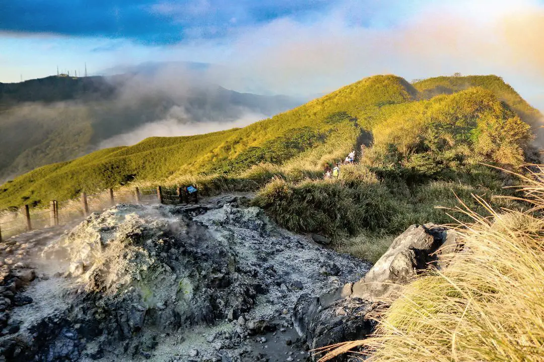
Yangmingshan National Park is a mountainous area in Taipei and New Taipei, known for its volcanic activity, hiking trails, wildlife, waterfalls, hot springs, and sulfur vents. It is definitely worth a stop on your trip to Taipei.
Historical Background: The area known as Yangmingshan now was formed by volcanoes about 700,000 years ago, forming many mountains about 1000 meters or less in northwestern Taiwan. The park still features active volcanoes, vents, and hot springs. The original name of the area was Caoshan (grass mountain 草山). During the Qing Dynasty, the area was used to harvest sulfur, and many of the hills were burned to help catch sulfur thieves, Qingtiangang likely being one of these areas. Sulfur mining was started in the Qing Dynasty by a British mining company that first obtained the rights to mine here in 1897. In 1927 during the Japanese era, Yangmingshan was made as the first national park in Taiwan, then known as Datunshan National Park Association. The area around Qingtiangang to Lengshuikeng was made into a ranch for water buffalo, and grass from Japan was planted here for them to graze. In 1950 after the ROC took Taiwan, Chiang Kai-shek renamed the park after the philosopher Wang Yangming, and called the area Yangmingshan. The KMT kept the ranch at Qingtiangang and continued to maintain it. They also built bunkers here and kept a garrison of troops. In 1985, after resolving many land disputes, Yangmingshan National Park was officially designated as a national park in the ROC era. Due to its easy accessibility from Taipei and many natural attractions, it is one of the most popular tourist destinations in Taipei City. Most visitors come on weekends, and it has parking lots and visitor's centers throughout the park. Hours: The visitor's centers are open from 9 AM to 4:30 PM. However you can visit the park 24/7. Price: Free entrance into the park (car parking 30-50 NT, scooter parking 20 NT) You can book tours to Yangmingshan on TripAdvisor here, Klook here, or KKday here or here. Tours: You can check out tours to Yangmingshan such as a One-day Yangmingshan NP Beitou Hot Spring Park and Tamsui Tour Package, Beitou and Yangmingshan Day Tour from Taipei, One Day Hike around Yangmingshan, or Private Yangmingshan Volcano Tour and more on TripAdvisor here, Klook here, or KKday here. When to Go: Silver Grass Season: Mang Grass season goes from September to November. During this time you will be able to see silvery grass all over the mountain tops around the park. Cherry Blossom Season: Cherry blossoms can be seen in the park from February to late March. Snowfall: Once every few years it can snow here from December to February. The snow usually only lasts a day or two and melts away quickly. Best Weather: In my opinion, the best weather is in the summer when constant rain makes the air cleaner, and summer mornings are usually clear. Be sure to start hiking in the morning for the best views and sunshine, as afternoon thundershowers are common. Hotels in Taipei: High end: We have stayed at and recommend the Yuanshan Grand Hotel, once the tallest building in Taiwan and still the most grand (book on Booking.com here, Tripadvisor here, or Agoda here). We have also stayed at and recommend the Grand Hyatt (book on Booking.com here, Tripadvisor here, Agoda here, or Hotels.com here), Marriot (book on Booking.com here, Tripadvisor here, Agoda here, or Hotels.com here), Sheraton (book on Booking.com here, Tripadvisor here, Agoda here, or Hotels.com here), Shangri-la (book on Booking.com here, Tripadvisor here, Agoda here, or Hotels.com here), and Regent (book on Booking.com here, Tripadvisor here, Agoda here, or Hotels.com here), which are all very high quality hotels in the middle of Taipei City. We also recommend Fullon Hotel which has locations in Tamsui and Fulong near the beach (book on Booking.com here, Tripadvisor here, Agoda here, or Hotels.com here). Budget Hotels: We have stayed at and also recommend Fu Chang Hotel in Ximending, which is within walking distance of Ximending shopping district (book on Booking.com here, Tripadvisor here, or Agoda here). We have also stayed at and recommend Hai Xia Your Home which is right in front of Fulong Beach (book on Booking.com here, Tripadvisor here, Agoda here, or Hotels.com here). Looking for a hotel? We recommend booking through Booking.com here, which provides the best quality selection of accommodation in Taiwan. Find out where to stay in our Taiwan hotels guide or search for the best hotel deals in Taiwan here. How to get there: By Car/Scooter: From Taipei, take provincial highway 2A north to the park, where you can see the main attractions such as Zhuzihu, Qixingshan, Datunshan, Qingtiangang, etc. There are many parking lots, but car parking is limited on weekends and the number of cars allowed up the mountain is also limited. There is also paid scooter parking. On weekends this place can be packed, and cars can be backed up for up to an hour or more, so consider taking a scooter or bus. Looking for scooter rental in Taipei? Check out Qeeq here, Klook here, or KKday here to search for options. You can also check out our scooter rental guide here. If you are looking for car rentals, you can also search Qeeq here, Klook here, or KKday here. You can also check out our car rental guide here. By Bus: From Beitou MRT Station, Take Little Bus 19 (小19), or another bus to the park. You can book tickets to travel to Taipei via inter-city bus on Klook here. You can book tickets to Taipei via high speed rail (HSR) on Klook here or KKDay here. By Bicycle: Cycling is the best way to enjoy Taiwan's landscapes if you have the time and energy. Looking for bicycle rentals in Taiwan? You can search on KKday here and search for tours on Klook here. You can also check out our Taiwan cycling guide here. Map: See below for a map of places mentioned in this blog: 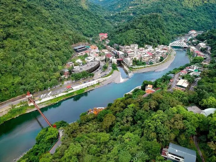
Wulai has become a major tourist attraction, partly because of its close proximity to Taipei. It has museums, waterfalls, a gondola, a train, an old street night market, and most of all hot springs. It has an old Japanese era coal mining railroad track which has been restored with a working train. In addition there are hikes, wildlife, and endless mountain scenery to explore.
Background: Wulai was originally an Atayal aborigine village, its name meaning hot and poisonous. There has always been natural hot springs in Wulai, but much of that water has been channeled into hotels and public bathhouses. The free hot springs stood at the bottom of the hill next to the river, and was a collection of used hot spring water from the hotels and paid hot springs above. In its prime, it boasted the largest free outdoor hot springs in Taiwan. Recently the District of Wulai in New Taipei has become a major tourist attraction, partly because of its close proximity to Taipei. It has museums, waterfalls, a gondola, a train, an old street night market, and most of all hot springs. The main delicacies on the old street are Taiwan ingenuous foods such as wild boar meat and rice steamed in bamboo. Hours: Wulai Old Street: Roughly 10 AM to 8 PM Cable Car and Yun Hsien Amusement Park Entrance: 9 AM to 4:30 PM You can book tickets to the gondola and to Yun Hsien theme park on Klook here or KKday here. Neidong Waterfall: 8 AM to 5 PM. You can book tickets to Neidong Forest Recreation Area on KKday here or Klook here. Price: Wulai Old Street: Free Cable Car and Yun Hsien Amusement Park Entrance: 220 NT per person You can book tickets to the gondola and to Yun Hsien theme park on Klook here or KKday here. Neidong Waterfall: 65 NT per person. You can book tickets on KKday here or Klook here. Hot Spring Bath: 300-500 NT. You can look for hot spring bath experiences on Klook here or KKday here. Delicacies: Wilde Boar meat, hot spring eggs, rice steamed in bamboo, among others. Hotels in Wulai: There are many hot spring hotels in Wulai that have a hot spring tub right in the room. We have stayed at and recommend Wulai SungLyu Hot Spring Resort, which is a hot spring resort with great views just above Wulai Old Street. You can book on Booking.com here, Agoda here, Hotels.com here, TripAdvisor here, Trip.com here, Klook here, Kayak here, or Expedia here. Looking for a hotel? We recommend booking through Booking.com here, which provides the best quality selection of accommodation in Taiwan. Find out where to stay in our Taiwan hotels guide or search for the best hotel deals in Taiwan here. How to get there: By Bus: From central Taipei, take bus 849 to Wulai Old Street. The trips takes about an hour and a half. You can purchase a discount easy card to use on a bus to Wulai on Klook here or KKday here. You can also book a Taipei travel pass on Klook here. By Car/Scooter: From Taipei, take provincial highway 9甲 to Wulai. There is a large paid parking garage in front of the old street. You may also be able to find free parking up the mountain. If you are looking for car rentals, you can also search Qeeq here, Klook here, or KKday here. You can also check out our car rental guide here. Looking for scooter rental in Taipei? You can search on Klook here or KKday here to search for options. You can also check out our scooter rental guide here. By Taxi: You can take short rides for about 150 NT, or hire a Taxi for a day for around 150 USD on Klook here. By Bicycle: Cycling is the best way to enjoy Taiwan's landscapes if you have the time and energy. Looking for bicycle rentals in Taiwan? You can use Taiwan's many Youbike sharing stations, or search for rentals on KKday here, and search for tours on Klook here. You can also check out our Taiwan cycling guide here. You can also book a Sunset Riverside Bike Ride and Historical Tour, 4 Hour Cycling in Taipei, Ultimate 8-Hour Cycling City Tour, or Taipei City Bike Tour with Night Market Experience on TripAdvisor here. For more information, check out our Taiwan transportation guide here. Map: Please see below of the places covered in this blog: 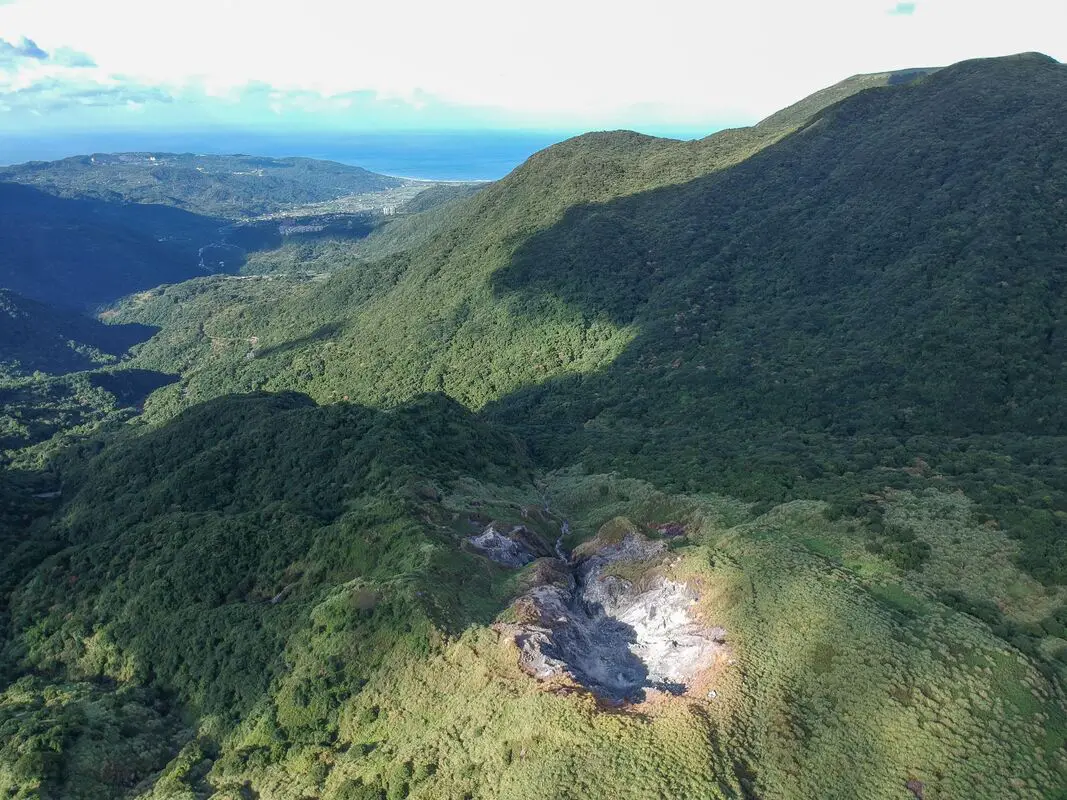
The Dayoukeng Crater in Yangmingshan National Park is the biggest sulfur vent area in Taiwan, and would likely be the first place to spew lava in the event of a volcanic eruption. This along with Turtle Island are the two known active volcanos in Taiwan. The area was also an important historical sulfur mine. Currently access to Dayoukeng is closed, but you can fly a drone hear with a permit.
Background: The area known as Yangmingshan now was formed by volcanoes about 700,000 years ago, forming many mountains about 1000 meters or less in northwestern Taiwan. The park still features active volcanoes, vents, and hot springs. The original name of the area was Caoshan (grass mountain 草山). During the Qing Dynasty, the area was used to harvest sulfur, and many of the hills were burned to help catch sulfur thieves. In 1927 during the Japanese era, Yangmingshan was made as the first national park in Taiwan, then known as Datunshan National Park Association. In 1950 after the ROC took Taiwan Chiang Kai-shek renamed the park after the philosopher Wang Yangming, and called the area Yangmingshan. In 1985, after resolving many land disputes, Yangmingshan National Park was officially designated as a national park in the ROC era. Dayoukeng (literally "Big Oil Crater" gets its name because the there are two main sulfur vents on Yangmingshan, and it is the biggest sulfur vent area in Taiwan. Temperatures here can reach 120 degrees celcious, and the water is very acidic with a PH level of only 1-2. The venting crater lies about 805 meters above sea level. A few kilometers under the ground, there is a leftover lava chamber from a previous eruption that heats up ground water and sends it spewing back to the surface. Sulfur mining at Dayoukeng Crater in Yangmingshan National Park started in the Qing Dynasty by a British mining company who first obtained the rights to mine here in 1897. Currently you can find lots of old mining equipment that were abandoned here. The Yulu Old Trail was built near Dayoukeng to transport mining materials. Mining sulfur ended with the formation of Yangmingshan National Park. Dayoukeng lies in Jinshan District of New Taipei City. It is a popular stop in Yangmingshan and has two parking lots and visitor's center. It is also one of the starting points for the Mt. Qixing Trail. Hours: The visitor's center is open from 9 AM to 4:30 PM. Price: Free (parking 30 NT) You can book tours to Yangmingshan on TripAdvisor here, Klook here, or KKday here or here. Tours: You can check out tours to Yangmingshan such as a One-day Yangmingshan NP Beitou Hot Spring Park and Tamsui Tour Package, Beitou and Yangmingshan Day Tour from Taipei, One Day Hike around Yangmingshan, or Private Yangmingshan Volcano Tour and more on TripAdvisor here, Klook here, or KKday here. Hotels in Taipei: High end: We have stayed at and recommend the Yuanshan Grand Hotel, once the tallest building in Taiwan and still the most grand (book on Booking.com here, Tripadvisor here, or Agoda here). We also recommend Fullon Hotel which has locations in Tamsui and Fulong near the beach (book on Booking.com here, Tripadvisor here, Agoda here, or Hotels.com here). Budget Hotels: We have stayed at and also recommend Fu Chang Hotel in Ximending, which is within walking distance of Ximending shopping district (book on Booking.com here, Tripadvisor here, or Agoda here). We have also stayed at and recommend Hai Xia Your Home which is right in front of Fulong Beach (book on Booking.com here, Tripadvisor here, Agoda here, or Hotels.com here). Looking for a hotel? We recommend booking through Booking.com here, which provides the best quality selection of accommodation in Taiwan. Find out where to stay in our Taiwan hotels guide or search for the best hotel deals in Taiwan here. How to get there: By Car/Scooter: From Taipei, take provincial highway 2A north to the Zhuzihu Lookout. Keep right until you reach the turnoff the the Qingtiangang parking lot. Car parking is limited on weekends and the number of cars allowed up the mountain is also limited. There is also paid scooter parking. Looking for scooter rental in Taipei? Check out Qeeq here, Klook here, or KKday here to search for options. If you are looking for car rentals, you can also search Qeeq here, Klook here, or KKday here. You can also check out our car rental guide here. By Bus: From Beitou MRT Station, Take Little Bus 9 (小9) to Qingtiangang Station (擎天崗). You can book tickets to travel to Taipei via inter-city bus on Klook here. By Bicycle: Cycling is the best way to enjoy Taiwan's landscapes if you have the time and energy. Looking for bicycle rentals in Taiwan? You can use Taiwan's many Youbike sharing stations, or search for rentals on KKday here, and search for tours on Klook here. You can also check out our Taiwan cycling guide here. You can also book a Sunset Riverside Bike Ride and Historical Tour, 4 Hour Cycling in Taipei, Ultimate 8-Hour Cycling City Tour, or Taipei City Bike Tour with Night Market Experience on TripAdvisor here. Map: Please see below: 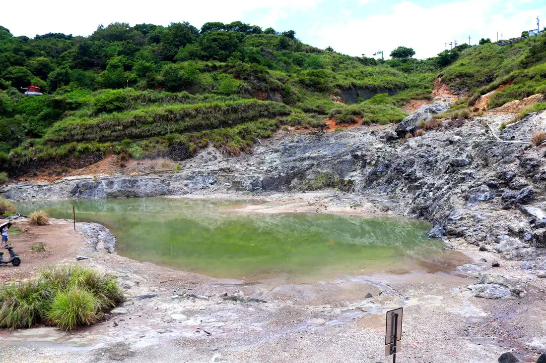
Longfeng Valley in Yangmingshan National Park is a large volcanic sulfur hot spring area with hiking trails, steam vents, sulfur deposits, and large natural hot springs. Longfeng Valley remains as a mostly untouched natural pool that retains its natural beauty without man made structures surrounding it. It is a unique and interesting stop on the mountain and worth a visit on your trip to Yangmingshan.
Background: The area known as Yangmingshan now was formed by volcanoes about 700,000 years ago, forming many mountains about 1000 meters or less in northwestern Taiwan. The park still features active volcanoes, vents, and hot springs. The original name of the area was Caoshan (grass mountain 草山). During the Qing Dynasty, the area was used to harvest sulfur, and many of the hills were burned to help catch sulfur thieves. In 1927 during the Japanese era, Yangmingshan was made as the first national park in Taiwan, then known as Datunshan National Park Association. In 1950 after the ROC took Taiwan Chiang Kai-shek renamed the park after the philosopher Wang Yangming, and called the area Yangmingshan. In 1985, after resolving many land disputes, Yangmingshan National Park was officially designated as a national park in the ROC era. The hot springs at Beitou were first converted into hot spring resorts in 1894, and Beitou become a popular hot spring location during the Japanese era, and there are many hot spring hotels and baths that exist there today. Longfeng Valley literally means "Dragon and Phoenix Valley." Longfeng Valley remains as a mostly untouched natural pool that retains its natural beauty without man made structures surrounding it. Hours: 24/7 Tours: You can book a Bath of the Gods Hot Spring Tour at Beitou, Taipei, 2-Hour Private Walking Tour in Beitou or Beitou and Yangmingshan Day Tour from Taipei and more on TripAdvisor here, Klook here, or KKday here. Hotels in Taipei: High end: We have stayed at and recommend the Yuanshan Grand Hotel, once the tallest building in Taiwan and still the most grand (book on Booking.com here, Tripadvisor here, or Agoda here). We also recommend Fullon Hotel which has locations in Tamsui and Fulong near the beach (book on Booking.com here, Tripadvisor here, Agoda here, or Hotels.com here). Budget Hotels: We have stayed at and also recommend Fu Chang Hotel in Ximending, which is within walking distance of Ximending shopping district (book on Booking.com here, Tripadvisor here, or Agoda here). We have also stayed at and recommend Hai Xia Your Home which is right in front of Fulong Beach (book on Booking.com here, Tripadvisor here, Agoda here, or Hotels.com here). Looking for a hotel? We recommend booking through Booking.com here, which provides the best quality selection of accommodation in Taiwan. Find out where to stay in our Taiwan hotels guide or search for the best hotel deals in Taiwan here. How to get there: By Bus: From Xinbeitou MRT station, take the 508 shuttle bus up the mountain to Dunu Vocational High School of Business, and then walk about five minutes down to the valley. You can book tickets to travel to Taipei via inter-city bus on Klook here. By Car/Scooter: From downtown Beitou, drive up Quanyuan Road until you reach Longfenggu Visitor's Center. You can park at the visitor's center or down in the valley below. Looking for scooter rental in Taipei? Check out Qeeq here, Klook here, or KKday here to search for options. You can also check out our scooter rental guide here. If you are looking for car rentals, you can also search Qeeq here, Klook here, or KKday here. You can also check out our car rental guide here. By Bicycle: Cycling is the best way to enjoy Taiwan's landscapes if you have the time and energy. Looking for bicycle rentals in Taiwan? You can use Taiwan's many Youbike sharing stations, or search for rentals on KKday here, and search for tours on Klook here. You can also check out our Taiwan cycling guide here. You can also book a Sunset Riverside Bike Ride and Historical Tour, 4 Hour Cycling in Taipei, Ultimate 8-Hour Cycling City Tour, or Taipei City Bike Tour with Night Market Experience on TripAdvisor here. Map: Please see below: 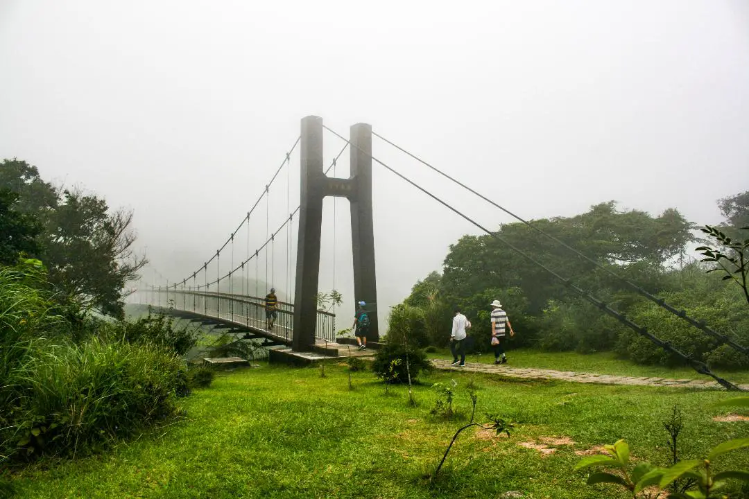
Lengshuikeng in Yangmingshan National Park is a small area with hiking trails, natural hot springs, waterfalls, and wildlife. Even though the name means "cold water hole," the water here is not cold, and there are plenty of hot springs around including a public hot spring bath house. It is a quiet a pleasant stop on the mountain and worth a visit on your trip to Yangmingshan.
Background: The area known as Yangmingshan now was formed by volcanoes about 700,000 years ago, forming many mountains about 1000 meters or less in northwestern Taiwan. The park still features active volcanoes, vents, and hot springs. The original name of the area was Caoshan (grass mountain 草山). During the Qing Dynasty, the area was used to harvest sulfur, and many of the hills were burned to help catch sulfur thieves. In 1927 during the Japanese era, Yangmingshan was made as the first national park in Taiwan, then known as Datunshan National Park Association. In 1950 after the ROC took Taiwan Chiang Kai-shek renamed the park after the philosopher Wang Yangming, and called the area Yangmingshan. In 1985, after resolving many land disputes, Yangmingshan National Park was officially designated as a national park in the ROC era. Lengshuikeng (literally "cold water crater" gets its name because the hot spring waters here are only 40 degrees centigrade, the coldest hot spring waters on Yangmingshan. Lengshuikeng has the only sulfur deposit sediment layer in Taiwan. Nearby are many hot springs and vents. It is a popular stop in Yangmingshan and has two parking lots and visitor's center. Hours: The visitor's center is open from 9 AM to 4:30 PM. Price: Free You can book tours to Yangmingshan on TripAdvisor here, Klook here, or KKday here or here. Tours: You can check out tours to Yangmingshan such as a One-day Yangmingshan NP Beitou Hot Spring Park and Tamsui Tour Package, Beitou and Yangmingshan Day Tour from Taipei, One Day Hike around Yangmingshan, or Private Yangmingshan Volcano Tour and more on TripAdvisor here, Klook here, or KKday here. How to get there: By Car/Scooter: From Taipei, take provincial highway 2A north to Chungshan Hall, and take a right, then continue down the road up the mountain to the left until you reach Lengshuikeng. Looking for scooter rental in Taipei? Check out Qeeq here, Klook here, or KKday here to search for options. You can also check out our scooter rental guide here. If you are looking for car rentals, you can also search Qeeq here, Klook here, or KKday here. You can also check out our car rental guide here. By Bus: From Shilin MRT Station, take bus S15 to Lengshuikeng Service Station. You can book tickets to travel to Taipei via inter-city bus on Klook here. By Bicycle: Cycling is the best way to enjoy Taiwan's landscapes if you have the time and energy. Looking for bicycle rentals in Taiwan? You can use Taiwan's many Youbike sharing stations, or search for rentals on KKday here, and search for tours on Klook here. You can also check out our Taiwan cycling guide here. You can also book a Sunset Riverside Bike Ride and Historical Tour, 4 Hour Cycling in Taipei, Ultimate 8-Hour Cycling City Tour, or Taipei City Bike Tour with Night Market Experience on TripAdvisor here. Map: Please see below: 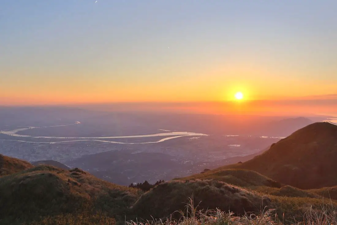
Qixingshan in Yangmingshan National Park (aka Qixing Mountain, Cising Mountain, Chising Mountain, or Seven Star Mountain) is considered the highest dormant volcanic peak in Taiwan, and the highest point in Taipei City. The area is also an important ecological area with protected species. There are a few paths to the top with varying difficulty, and it offers great views of the Taipei Basin and the sunset.
Background: The area known as Yangmingshan now was formed by volcanoes more than 700,000 years ago, forming many mountains about 1000 meters or less in northwestern Taiwan. The park still features active volcanoes, vents, and hot springs. The original name of the area was Caoshan (grass mountain 草山). During the Qing Dynasty, the area was used to harvest sulfur, and many of the hills were burned to help catch sulfur thieves. In 1927 during the Japanese era, Yangmingshan was made as the first national park in Taiwan, then known as Datunshan National Park Association. In 1950 after the ROC took Taiwan Chiang Kai-shek renamed the park after the philosopher Wang Yangming, and called the area Yangmingshan. In 1985, after resolving many land disputes, Yangmingshan National Park was officially designated as a national park in the ROC era. Qixingshan is 1120 meters tall, and is known as the highest dormant volcano in Taiwan. The last eruption here was about 700,000 years ago. Originally the peak had a crater but it slowly eroded into seven peaks, which is how it got its name. It is also known to snow in the area. Qixingshan lies in Beitou District of New Taipei City. It is a popular stop in Yangmingshan and has three main trails up to the top. There is a large viewing platform that has great views of the Taipei Basin and the sunset. Hours: 24/7 Price: Free (parking 30 NT) You can book tours to Yangmingshan on TripAdvisor here, Klook here, or KKday here or here. Tours: You can check out tours to Yangmingshan such as a One-day Yangmingshan NP Beitou Hot Spring Park and Tamsui Tour Package, Beitou and Yangmingshan Day Tour from Taipei, One Day Hike around Yangmingshan, or Private Yangmingshan Volcano Tour and more on TripAdvisor here, Klook here, or KKday here. Difficulty: There are three trails that you can take to the top. Here is a dissections of each trail: From Miaopu: Moderate: : 700 meter elevation gain, 2.4 KM of walking one way, 2 hours to the top and 2 hours back (4 hours round trip). This is the most difficult way up. From Xiaoyoukeng: Easy: 400 meter elevation gain, 1.6 KM walk one way, 40 minutes to the top and 40 minutes back (1.5 hours round trip). This is the easiest way up. From Lengshuikeng/Menghuan Pond: Easy: 450 meter elevation gain, 2.1 KM walk one way, 45 minutes to the top and 45 minutes back (1.5 hours round trip). For a more detailed comparison of the three trails, check out this blog by Josh Ellis. Hotels in Taipei: High end: We have stayed at and recommend the Yuanshan Grand Hotel, once the tallest building in Taiwan and still the most grand (book on Booking.com here, Tripadvisor here, or Agoda here). We also recommend Fullon Hotel which has locations in Tamsui and Fulong near the beach (book on Booking.com here, Tripadvisor here, Agoda here, or Hotels.com here). Budget Hotels: We have stayed at and also recommend Fu Chang Hotel in Ximending, which is within walking distance of Ximending shopping district (book on Booking.com here, Tripadvisor here, or Agoda here). We have also stayed at and recommend Hai Xia Your Home which is right in front of Fulong Beach (book on Booking.com here, Tripadvisor here, Agoda here, or Hotels.com here). Looking for a hotel? We recommend booking through Booking.com here, which provides the best quality selection of accommodation in Taiwan. Find out where to stay in our Taiwan hotels guide or search for the best hotel deals in Taiwan here. How to get there: By Car/Scooter: From Taipei, take provincial highway 2A north to Yangmingshan. There are three trails to the top: from Xiaoyoukeng 小油坑, Lengshuikeng 冷水坑, and Miaopu 苗圃. Looking for scooter rental in Taipei? Check out Qeeq here, Klook here, or KKday here to search for options. If you are looking for car rentals, you can also search Qeeq here, Klook here, or KKday here. You can also check out our car rental guide here. By Bus: From Shilin MRT Station, Take Bus 1717 to Xiaoyoukeng 小油坑, Lengshuikeng 冷水坑, Menghuan Pond 夢幻胡 or Miaopu 苗圃 parking lots. You can book tickets to travel to Taipei via inter-city bus on Klook here. By Bicycle: Cycling is the best way to enjoy Taiwan's landscapes if you have the time and energy. Looking for bicycle rentals in Taiwan? You can search on KKday here and search for tours on Klook here. You can also check out our Taiwan cycling guide here. Map: Please see below: 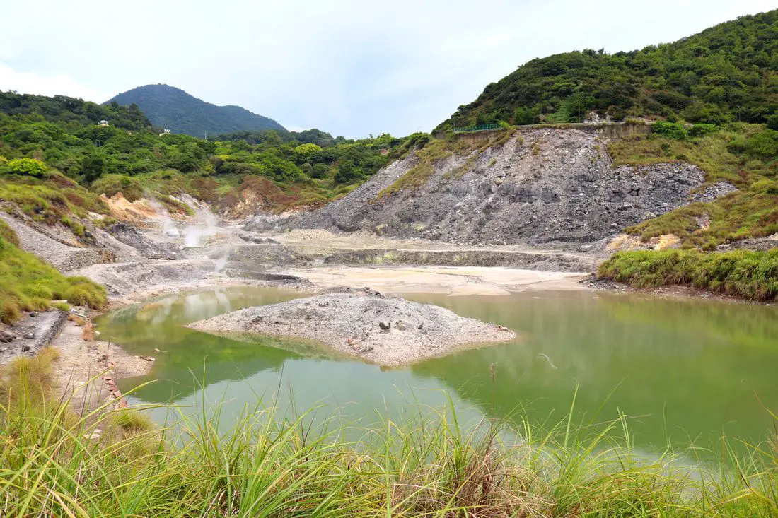
Sulfur Valley (Liuhuang Valley) in Yangmingshan National Park is a large volcanic sulfur hot spring area with hiking trails, steam vents, sulfur deposits, and large natural hot springs. Sulfur Valley contains a trail that circles the area, and also has a free public spring to soak your feet in. It is a unique and interesting stop on the mountain and worth a visit on your trip to Yangmingshan.
Background: The area known as Yangmingshan now was formed by volcanoes about 700,000 years ago, forming many mountains about 1000 meters or less in northwestern Taiwan. The park still features active volcanoes, vents, and hot springs. The original name of the area was Caoshan (grass mountain 草山). During the Qing Dynasty, the area was used to harvest sulfur, and many of the hills were burned to help catch sulfur thieves. In 1927 during the Japanese era, Yangmingshan was made as the first national park in Taiwan, then known as Datunshan National Park Association. In 1950 after the ROC took Taiwan Chiang Kai-shek renamed the park after the philosopher Wang Yangming, and called the area Yangmingshan. In 1985, after resolving many land disputes, Yangmingshan National Park was officially designated as a national park in the ROC era. The hot springs at Beitou were first converted into hot spring resorts in 1894, and Beitou become a popular hot spring location during the Japanese era, and there are many hot spring hotels and baths that exist there today. Sulfur Valley is also the source of some of the hot spring water for Beitou Hot Springs. Hours: 24/7 Activities: You can book a rock climbing experience at Sulphur Valley on Klook here or KKday here. Tours: You can check out tours to Yangmingshan such as a One-day Yangmingshan NP Beitou Hot Spring Park and Tamsui Tour Package, Beitou and Yangmingshan Day Tour from Taipei, One Day Hike around Yangmingshan, or Private Yangmingshan Volcano Tour and more on TripAdvisor here, Klook here, or KKday here. Hotels in Taipei: High end: We have stayed at and recommend the Yuanshan Grand Hotel, once the tallest building in Taiwan and still the most grand (book on Booking.com here, Tripadvisor here, or Agoda here). We also recommend Fullon Hotel which has locations in Tamsui and Fulong near the beach (book on Booking.com here, Tripadvisor here, Agoda here, or Hotels.com here). Budget Hotels: We have stayed at and also recommend Fu Chang Hotel in Ximending, which is within walking distance of Ximending shopping district (book on Booking.com here, Tripadvisor here, or Agoda here). We have also stayed at and recommend Hai Xia Your Home which is right in front of Fulong Beach (book on Booking.com here, Tripadvisor here, Agoda here, or Hotels.com here). Looking for a hotel? We recommend booking through Booking.com here, which provides the best quality selection of accommodation in Taiwan. Find out where to stay in our Taiwan hotels guide or search for the best hotel deals in Taiwan here. How to get there: By Bus: From near Xinbeitou MRT station, take the S9 or S26 bus up the mountain to Mito Temple (Sulfur Valley) bus stop. You can book tickets to travel to Taipei via inter-city bus on Klook here. By Car/Scooter: From downtown Beitou, drive up Quanyuan Road until you reach the Sulfur Valley Parking lot, you can park there or on the side of the road. Looking for scooter rental in Taipei? Check out Qeeq here, Klook here, or KKday here to search for options. You can also check out our scooter rental guide here. If you are looking for car rentals, you can also search Qeeq here, Klook here, or KKday here. You can also check out our car rental guide here. By Bicycle: Cycling is the best way to enjoy Taiwan's landscapes if you have the time and energy. Looking for bicycle rentals in Taiwan? You can use Taiwan's many Youbike sharing stations, or search for rentals on KKday here, and search for tours on Klook here. You can also check out our Taiwan cycling guide here. ​You can also book a Sunset Riverside Bike Ride and Historical Tour, 4 Hour Cycling in Taipei, Ultimate 8-Hour Cycling City Tour, or Taipei City Bike Tour with Night Market Experience on TripAdvisor here. Map: Please see below: 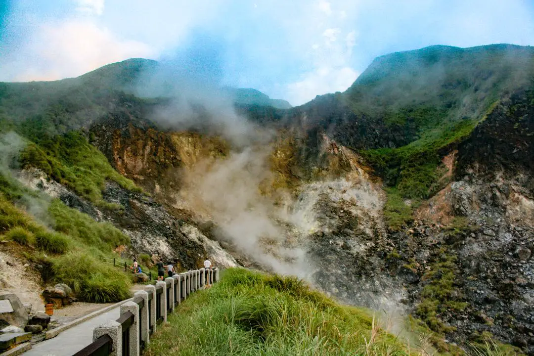
Xiaoyoukeng in Yangmingshan National Park is a large volcanic steam vent area with hiking trails, fumaroles, sulfur deposits, and natural hot springs. Even though the name means "small sulfur hole," it is perhaps the largest and most easily accessible volcanic steam vent area in Taiwan. One could say that it is the Yellowstone of Taiwan. It is a quiet a pleasant stop on the mountain and worth a visit on your trip to Yangmingshan.
Background: The area known as Yangmingshan now was formed by volcanoes about 700,000 years ago, forming many mountains about 1000 meters or less in northwestern Taiwan. The park still features active volcanoes, vents, and hot springs. The original name of the area was Caoshan (grass mountain 草山). During the Qing Dynasty, the area was used to harvest sulfur, and many of the hills were burned to help catch sulfur thieves. In 1927 during the Japanese era, Yangmingshan was made as the first national park in Taiwan, then known as Datunshan National Park Association. In 1950 after the ROC took Taiwan Chiang Kai-shek renamed the park after the philosopher Wang Yangming, and called the area Yangmingshan. In 1985, after resolving many land disputes, Yangmingshan National Park was officially designated as a national park in the ROC era. Xiaouyoukeng (literally "Small Oil Crater" gets its name because the there are two main sulfur vents on Yangmingshan, and it was thought to be the smaller one. The venting crater lies about 805 meters above sea level. A few kilometers under the ground, there is a leftover lava chamber from a previous eruption that heats up ground water and sends it spewing back to the surface. It is a popular stop in Yangmingshan and has two parking lots and visitor's center. It is also one of the starting points for the Mt. Qixing Trail. Hours: The visitor's center is open from 9 AM to 4:30 PM. Price: Free (parking 30 NT) You can book tours to Yangmingshan on TripAdvisor here, Klook here, or KKday here or here. Tours: You can check out tours to Yangmingshan such as a One-day Yangmingshan NP Beitou Hot Spring Park and Tamsui Tour Package, Beitou and Yangmingshan Day Tour from Taipei, One Day Hike around Yangmingshan, or Private Yangmingshan Volcano Tour and more on TripAdvisor here, Klook here, or KKday here. Hotels in Taipei: High end: We have stayed at and recommend the Yuanshan Grand Hotel, once the tallest building in Taiwan and still the most grand (book on Booking.com here, Tripadvisor here, or Agoda here). We also recommend Fullon Hotel which has locations in Tamsui and Fulong near the beach (book on Booking.com here, Tripadvisor here, Agoda here, or Hotels.com here). Budget Hotels: We have stayed at and also recommend Fu Chang Hotel in Ximending, which is within walking distance of Ximending shopping district (book on Booking.com here, Tripadvisor here, or Agoda here). We have also stayed at and recommend Hai Xia Your Home which is right in front of Fulong Beach (book on Booking.com here, Tripadvisor here, Agoda here, or Hotels.com here). Looking for a hotel? We recommend booking through Booking.com here, which provides the best quality selection of accommodation in Taiwan. Find out where to stay in our Taiwan hotels guide or search for the best hotel deals in Taiwan here. How to get there: By Car/Scooter: From Taipei, take provincial highway 2A north to the Zhizihu Lookout. Keep right until you reach the turnoff the the Xiaoyoukeng parking lot on the right. Car parking is limited on weekends and the number of cars allowed up the mountain is also limited. There is also paid scooter parking. Looking for scooter rental in Taipei? Check out Qeeq here, Klook here, or KKday here to search for options. If you are looking for car rentals, you can also search Qeeq here, Klook here, or KKday here. You can also check out our car rental guide here. By Bus: From Beitou MRT Station, Take Little Bus 9 (小9) to Xiaoyoukeng Station (小油坑). You can book tickets to travel to Taipei via inter-city bus on Klook here. By Bicycle: Cycling is the best way to enjoy Taiwan's landscapes if you have the time and energy. Looking for bicycle rentals in Taiwan? You can use Taiwan's many Youbike sharing stations, or search for rentals on KKday here, and search for tours on Klook here. You can also check out our Taiwan cycling guide here. You can also book a Sunset Riverside Bike Ride and Historical Tour, 4 Hour Cycling in Taipei, Ultimate 8-Hour Cycling City Tour, or Taipei City Bike Tour with Night Market Experience on TripAdvisor here. Map: Please see below: 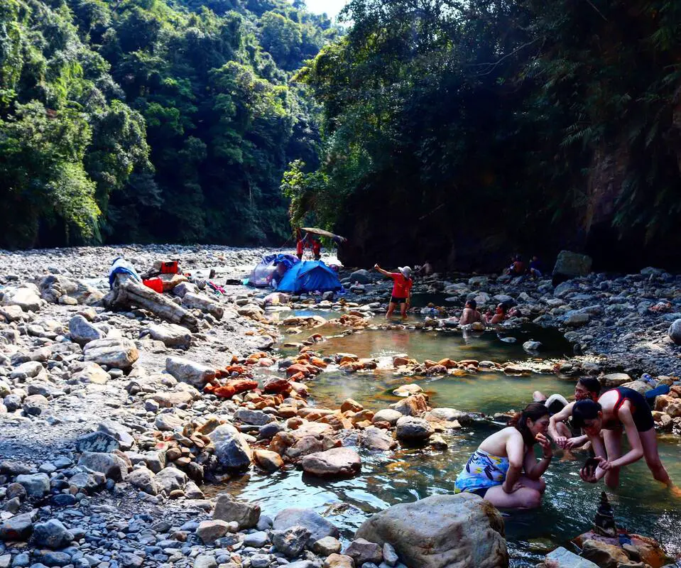
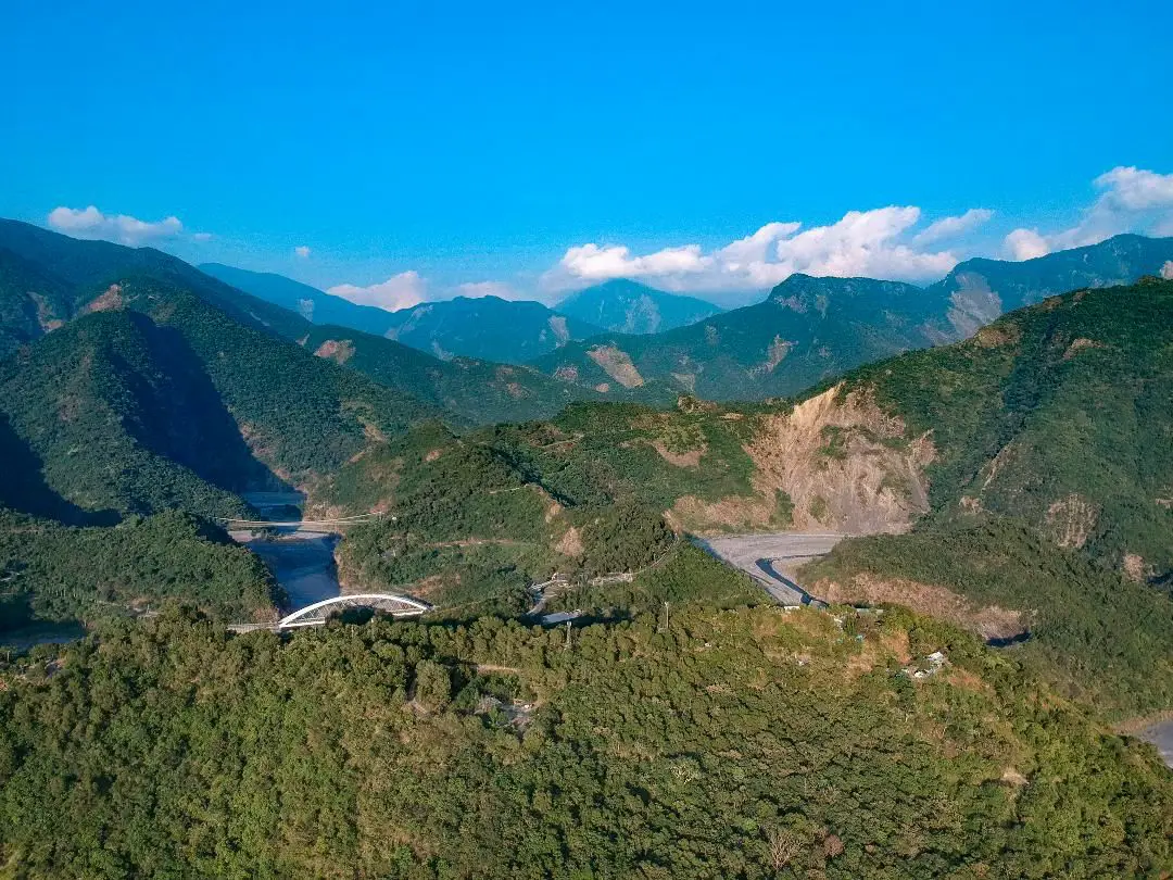
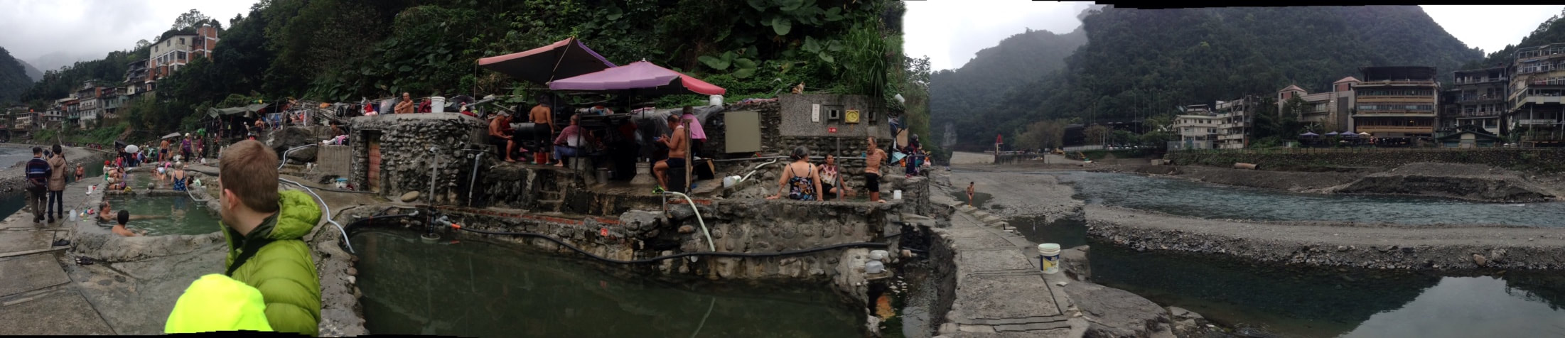
Fanfan Hot Spring is a popular hot spring in Yingshi Village, Datong Township, Yilan County. It is one of the most easily accessible wild hot springs in Taiwan, so it sees many visitors year round. If you are in the area, you should consider taking a dip here.
Background: The area around Fanfan Hot Spring has been inhabited by the Atayal tribe for thousands of years. Originally the river where the hot springs lay was called Bonbon by the local indigenous people, but later the spelling was changed to "Fanfan" because of Han Chinese people in the area who misheard the name. Fanfan Hot Springs is part of the Xueshan Mountain Range, which was pushed up from the collision of the Eurasian and Philippine plate. The hot springs come from heated water caused from metamorphic rocks under pressure deep within the earth. Hours: 24/7 Tours and Activities: You can purchase tours and tickets for many activities in Yilan such as Su'ao Crayon Castle, Taipingshan, Turtle Island, Lanyang Museum, Toucheng Leisure Farm, Zhang Mei Ama Capybura Farm, Bambi Land, Yinong Ranch, National Center for Traditional Arts, Taxi Museum, Glamping, Camping, ATV / 4-wheeling experience, SUP / paddle boarding, Ximeng Forest Theater, Surfing, Kayaking, Horse Riding, River Tracing, River Rafting, River Tubing, Pack Rafting, Water Biking, Snorkeling, Canoeing, Shrimping and many others through Klook here or KKday here. Accommodation: Looking for a hotel? We recommend booking through Agoda here, which provides the best quality selection of accommodation on the islands. We have stayed at and recommend Ying Shih Guest House, a resort in Datong Township near Taipingshan and Fan Fan Hot Spring (you can book on Agoda here or Booking.com here), and Jiaosi Hotspring Hotel, a hotel with hot springs in each room (you can book on Agoda here, Booking.com here, Hotels.com here, Expedia here, or Trip.com here). You can also book Wifi and SIM cards for Taiwan on Gigago here. Need travel insurance? Compare prices on Insubuy here. Just to let you know, if you book using the links above, we get some commission at no cost to you, and you can help support our blog. You can click here to receive $5 USD on your first Klook purchase. How to get there: By Bus: From Yilan Bus Station, take bus 1744 about one hour to Fanfan Station. The hot springs are about a 20 minute walk away. You can book tickets to travel to Yilan via inter-city bus on Klook here. You can book tickets to Yialn via high speed rail (HSR) on Klook here or KKDay here. Book tickets via the normal train (TRA) on Klook here. Bicycle rental: Cycling is the best way to enjoy Taiwan's landscapes if you have the time and energy. Looking for bicycle rentals in Taiwan? You can search on KKday here and search for tours on Klook here. You can also check out our Taiwan cycling guide here. By Car/Scooter: From downtown Yilan, take provincial higway 7 southwest to Siji Elementary School Yingshi Branch, in Yingshi village. There is parking at the elementary school. The hot springs are about a 15 minute walk away. Looking for scooter rental in Yilan? You can search Klook here or KKday here to look for options. You can also check out our scooter rental guide here. If you are looking for car rentals in Yilan, you can also search Klook here or KKDay here. You can also check out our car rental guide here. Map: Please see below: 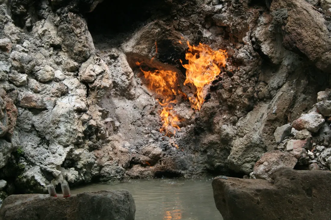
FIRE hot springs! What other reason do you need to visit this place? Hopefully that should be enough, because there is not much else to see besides a natural gas fire and a hot spring. It's name Chinese literally means water and fire coming from the same source (水火同源). Some have called it one of the seven wonders of Taiwan. This is a place that we have wanted to go for a long time, and the first place that we have checked off of our “secret places” list.
Historical Background: According to local Chinese folklore, the Kirin, a mythical Chinese Dragon-Horse creature, is said to have long ago lived in the spot where the fire spring now stands. The spring water is his leftover urine and the fire his breath. This legend comes purely from the sign above. Another legend from the Taiwan Tourism website says that the legend is actually about two dragons: a fire dragon and a water dragon. They both lost in battle, one became the spring's water and the other the spring's fire. In recent times the cave has become a popular tourist location especially for people enjoying the hot spring hotels in Guanziling. Hours: 24/7 Price: Free
How to get there:
By car/scooter: We came south on National Highway 3 from Jiayi and exited near Tainan Baihe district. Looking for scooter rental in Tainan? You can search KKday here or Klook here to look for options. You can also check out our scooter rental guide here. If you are looking for car rentals in Tainan, you can also search Klook here or KKDay here. You can also check out our car rental guide here. By Bus: If you do not have a vehicle, Water and Fire hot spring can also be reached via Xinying Bus (新營客運) or tour bus. You can book tickets to travel to Tainan via inter-city bus on Klook here. You can book tickets to Tainan via high speed rail (HSR) on Klook here or KKDay here. Book tickets via the normal train (TRA) on Klook here. Where to stay? Most of the accommodation you will find is near the city center. If you only want to visit old Tainan, you can book a hotel near the west part of downtown and consider walking or cycling around the city. We have stayed at and recommend Liho Hotel, a quality hotel right next to Chikan Tower, and Famouse Hotel, which is another great hotel also within walking distance of Chikan Tower in old Tainan. You can find out where to stay in our Taiwan hotels guide or search for the best hotel deals in Taiwan here. Need travel insurance? Compare prices on Insubuy here. You can also book Wifi and SIM cards for Taiwan on Gigago here. Tours: You can find more tours and activities in Tainan such as SUPing / Paddle Boarding, Oyster Harvesting , Wind Surfing, Glamping and more on Klook here or KKday here. Map: 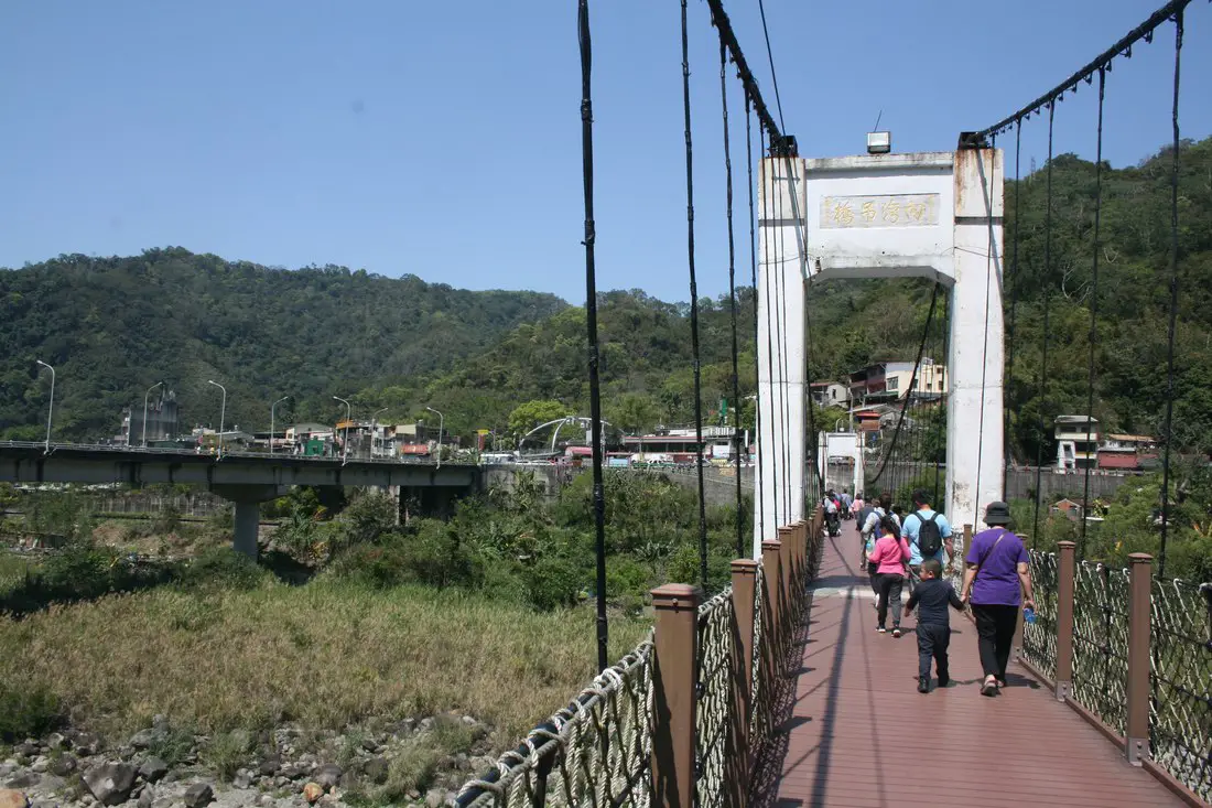
The first time I heard of Neiwan old street was when I asked my Mioali native coworker what there is to do in Miaoli. She told me there was a fun place called Neiwan. It turns out, Neiwan isn't even in Miaoli, it's in Hsinchu, but obviously, it is one of the most popular places in north-central Taiwan. I am not an expert on this location, but I would like to share my experience here with the world.
History: During the Japanese rule of Taiwan, Neiwan was mainly a lumber-driven town, as well as other industries such as mining and mineral extraction. Many Japanese-era buildings still remain in the city, such as the well-preserved police station. The main ethnicity here is Hakka, and you can still find lots of traditional Hakka food in Neiwan like their famed Zongzi. Some popular destinations for tourists are the Neiwan Theatre (内灣戲院), built in 1950 and which was converted into a restaurant (recently closed), as well as the Neiwan Suspension bridge (pictured above). The Neiwan railway was started in 1944 by the ruling Japanese, but construction was interrupted by WWII. It was completed by the ROC government in 1951 to help transport mainly lumber and lime. Now it is used as a commuter train for the suburbs of Hsinchu as well as a destination for tourists. Tours: You can find more tours and activities in Hsinchu such as You can find more tours and activities in Hsinchu such as river tracing, wild hot springs, white water kayaking, backpack rafting, Little Ding Dong Theme Park, Leofoo Village Theme Park, Window on China Theme Park, glamping, camping, stone spa, horse riding, Yukids Island, Tom and Bei Bei Parent Child Paradise, bee keeping experience, cycling, dried persimmons experience, Jump Wave Trampoline Park and more on Klook here or KKday here. Where to stay: Most of the accommodation you will find is near the city center. If you will only visit downtown, you can consider a day trip from Taipei. We have stayed at and recommend the Golden Motel a high quality motel near Green Grass Lake (you can book on Agoda here, Booking.com here, Hotels.com here, Expedia here, or Trip.com here), and CD Motel, another high quality motel in downtown Hsinchu (you can book on Agoda here, Booking.com here, or Trip.com here). Unfortunately I cannot recommend any further hotels that I have stayed at in Hsinchu because usually we stay at my wife's uncle's house. You can find out where to stay in our Taiwan hotels guide or search for the best hotel deals in Taiwan here. You can also book Wifi and SIM cards for Taiwan on Gigago here. Need travel insurance? Compare prices on Insubuy here. Just to let you know, if you book using the links above, we get some commission at no cost to you, and you can help support our blog. You can click here to receive $5 USD on your first Klook purchase. How to get there: By Train: Get off at Zhudong station and then take the Neiwan Liujia line. This takes about an hour from Hsinchu. You can book a bus ticket and railroad pass for Neiwan Old Street on KKday here. By Car/Scooter: From Taipei, take National Highway 3 to the Guanxi Exit and travel down provincial highway 3 to Neiwan. There is a lot of paid parking near the old street. If you are looking for car rentals in Hsinchu, you can also search Qeeq here, Klook here, or KKDay here. You can also check out our car rental guide here. Looking for scooter rental in Hsinchu? You can search Klook here or KKday here to look for options. You can also check out our scooter rental guide here. By Bicycle: Cycling is the best way to enjoy Taiwan's landscapes if you have the time and energy. Looking for bicycle rentals in Taiwan? You can search on KKday here and Klook here. You can also check out our Taiwan cycling guide here. Map:
As of May this year, Wulai public hot springs have been destroyed. For many of us, Wulai hot springs were a relaxing place to become one with nature and enjoy conversing with locals. To honor their memory, we have written this post.
History of Wulai Hot Springs
Wulai was originally an Atayal aborigine village, its name meaning hot and poisonous. There has always been natural hot springs in Wulai, but much of that water has been channeled into hotels and public bathhouses. The free hot springs stood at the bottom of the hill next to the river, and was a collection of used hot spring water from the hotels and paid hot springs above. In its prime, it boasted the largest free outdoor hot springs in Taiwan. Recently the township of Wulai has become a major tourist attraction, partly because of its close proximity to Taipei. It has museums, waterfalls, a gondola, a train (under renovation), a night market, and most of all hot springs. In 2015 Typhoon Soudelor wreaked havoc to the town and destroyed many hot springs. Due to this and sanitation concerns, New Taipei City decided to shut down the hot springs, and gave the owners until April 2017 to tear it down. When the owners did not comply, New Taipei took the matter in their own hands and tore down the springs in May 2017. Experience
My experience at Wulai springs was quite peaceful. When I was there last February, there were many pools to choose from with varying temperatures. Also, there were many free showers there made from recycled billboards. Some pools were full of dead skin, but the water was changed out every hour (even so, the new water coming in was also not guaranteed to be clean, although it was just as clean as any cheap public hot spring you would find in Beitou). I must admit that the average demographic there was 65 and older Taiwanese people, but I imagine they came there regularly, so now that the springs are demolished their daily relaxed routine of soaking in the springs is gone. They are the true victims of this demolition.
Next to the springs was a hole that captured the spring water mixed with river water. Although some of the water was foamy, it was relaxing swimming in the cool calm water after a dip in the springs. Perhaps the best part of the experience was the great mountain view and fresh air. In spring, there were also cherry blossoms on the hills for all to enjoy. 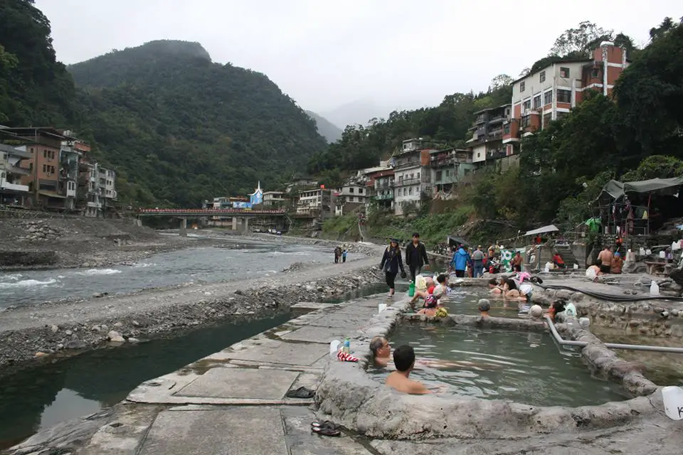
Safety Concerns
The New Taipei City government said the water from these springs was too filthy and polluting the river. Also they claimed it was hard to evacuate people using the springs during a Typhoon. In 2015 there were two fatalities during typhoon Soudelor; both these people were using the hot springs during the typhoon. In addition, the river is officially restricted from building anything. Because of these factors the government worked to shut these hot springs down. 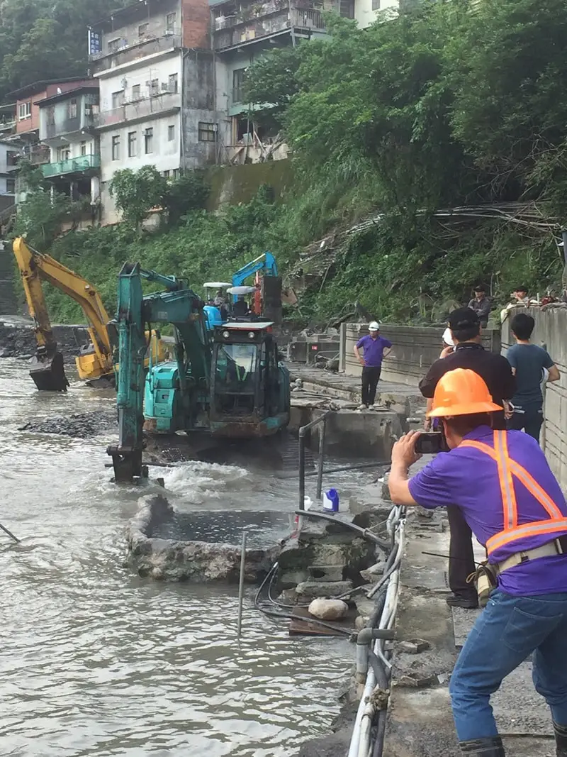
Photo credit: https://www.taiwannews.com.tw/en/news/3166954
Our Thoughts Personally, I think the private hot spring hotel owners in Wulai worked together to lobby against the public hot springs and bring them down so that they could make an extra buck. The New Taipei City government should have taken over the public springs to make them safer, cleaner, and legal: this would have brought tourists and money to the community. Those that want to go to free hot springs will now visit elsewhere. We are very sad to see these hot springs go, and consider ourselves lucky to have enjoyed them while they lasted. But with all things that are fun, eventually some law or regulation will shut them down. I hope that someday New Taipei City government will have the foresight to rebuild them into a legal, safe, and free hot springs again. Please leave your comments, memories, or other thoughts below, and don't forget to like and share! |
Author 作家I am an American expat who has extensive experience living, working, and traveling in Taiwan. In my day, I had to learn many things about Taiwan the hard way. But I have come to learn that Taiwan is one of the best places in the world for Foreigners to live. This blog does not represent the opinions of every foreigner in Taiwan. I am just trying to help others learn more about this beautiful country. Categories
|
 RSS Feed
