

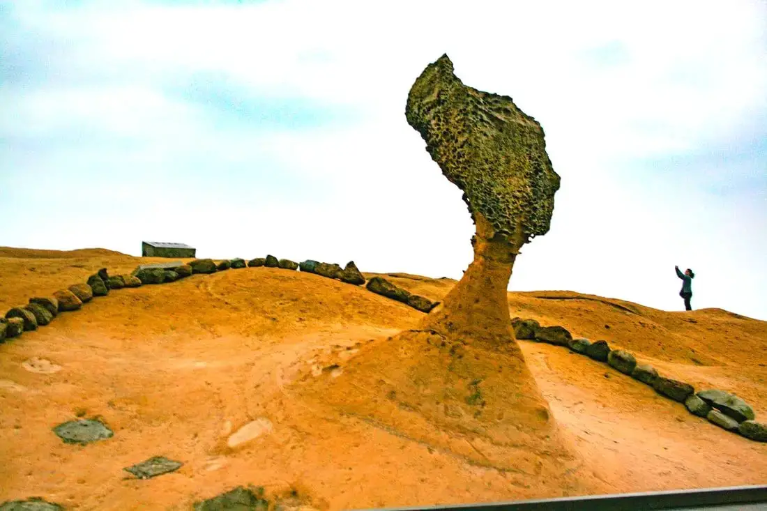
Yehliu is perhaps the most famous geological park in Taiwan, with its most famous landmark being the Queen's Head rock. These rock formations have been forming for thousands of years through erosion of soft sandstone due to wind and water. Hurry and see these formations soon before they are gone forever!
Background: The sandstone that forms the Yehliu formation was created between 10 and 20 million years ago, and was pushed out of the sea along with northern Taiwan thousands of years ago. The Queen's head is formed by two layers of sandstone, one soft fast eroding layer on bottom and a harder layer on top. This kind of sandstone formation can be seen around the world and is known as a hoodoo. The Queen's head was named after Queen Elizabeth I, because it is thought to look like her. The head is eroding .2 to .5 CM per year and is expected to fall at any time! The name Yehliu comes from the Spanish name for the area "Putno Diablos" which was then also used by the Dutch, and transliterated by the Chinese settlers in the area as "Yehliu" in Chinese. Yehliu Ocean world is the largest aquarium in northern Taiwan and has one of the few outdoor sea life amphitheaters in Taiwan. The facility features an indoor aquarium and outdoor show that is geared toward children. Hours: Yehliu Geopark: 8 AM to 5 PM in winter (tickets not sold after 4:30) 8 AM to 6 PM in summer (tickets not sold after 5:30) Yehliu Ocean World: 9 AM to 5 PM Price: Yehliu Geopark: 120 NT per person. You can book discount tickets to Yehliu Geopark on Klook here and KKday here. Yehliu Ocean World: 450 NT per person. You can book discount tickets to Yehliu Ocean World on Klook here and KKday here. You can also book tickets to the Yehliu Ocean World Parent-Child playground on Klook here. Tours: You can book a tour to Yehliu on TripAdvisor here, Klook here, or KKday here. Can I touch the rocks? Don't you dare touch the rocks! Activities along Taiwan's Northern Coast: Don't forget that there are many activities available along Taiwan's Northern Coast such as Wakeboarding, Surfing, Speedboat Surfing, SUP / Paddle Boarding, Diving, Snorkeling Kayaking, Canoeing, Water Biking, River Tracing / Canyoneering, ATVing, Horse Riding, Archery, Tree Climbing, Glamping, Motorcycling, Motorbike Tour, Dragon Boat Racing, Shen'ao Rail Bike, and more on Tripadvisor here, Klook here, or KKday here. Hotels on Taiwan's Northern Coast: We recommend Fullon Hotel which has locations in Tamsui and Fulong near the beach (book on Booking.com here, Tripadvisor here, Agoda here, or Hotels.com here). We have stayed at and recommend Gold Mountain Ranch, which is a horse ranch and glamping destination in Jinshan. You can book a night at Gold Mountain Ranch on Klook here. You can also check out our full blog on the ranch here. We have also stayed at and recommend Hai Xia Your Home which is right in front of Fulong Beach (book on Booking.com here, Tripadvisor here, Agoda here, or Hotels.com here). Looking for a hotel? We recommend booking through Booking.com here, which provides the best quality selection of accommodation in Taiwan. Find out where to stay in our Taiwan hotels guide or search for the best hotel deals in Taiwan here. How to get there: By Bus: There are inter-city buses that leave hourly from Taipei Main Station and Taipei City Hall to Yehliu. You can purchase a discount easy card to use on the MRT and buses from Klook here or KKday here. You can also book an MRT travel pass on Klook here. By Car/Scooter: Take Provincial highway 2 west out of Keelung, and keep going until you reach Wanli. The turnoff to Yehliu comes right after Wanli beach. If you are looking for car rentals, you can also search Qeeq here, Klook here, or KKday here. You can also check out our car rental guide here. Looking for scooter rental in northern Taiwan? You can search on Klook here or KKday here to search for options. You can also check out our scooter rental guide here. By Bicycle: Cycling is the best way to enjoy Taiwan's landscapes if you have the time and energy. Looking for bicycle rentals in Taiwan? You can use Taiwan's many Youbike sharing stations, or search for rentals on KKday here, and search for tours on Klook here. You can also check out our Taiwan cycling guide here. You can also book a cycling tour on TripAdvisor here. For more information, check out our Taiwan transportation guide here. Map: Please see below:
0 Comments
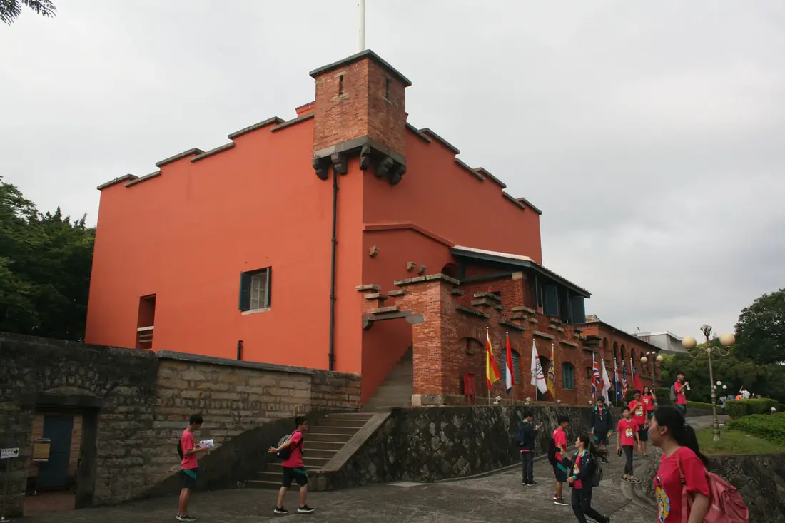
Fort San Domingo (aka 紅毛城 Hongmaocheng, “City of Red Hair") is one of the oldest buildings in Taiwan, with a nearly 400 year history. Originally built by the Spanish, it was handed over to nine different nations including the Dutch, Qing, Japan, British, Australia, USA, and the ROC. Now it is a popular tourist destination in Tamsui.
Background: Fort San Domingo was originally a wooden fort built by the Spanish who were vying for control of Taiwan in 1628. Later the fort came into Dutch control in 1642, and the Spanish were driven from Taiwan. In the process, the Spanish razed the fort to the ground. The fort was rebuilt in brick by the Dutch. The Dutch were expelled from Taiwan thanks to Konxinga and his Ming loyalists. After the Qing dynasty took Taiwan from the Ming loyalists, they repaired the fort in 1724. The local Han Chinese at the time called the fort "Red Hair Fort 紅毛城" as a racial slur to the Dutch. Later, the fort was leased to the British government, who continued to keep a presence there until 1972, and later it was given for a short time to Australia and the USA, and then given to the ROC government in 1980. Now the government maintains the fort as a tourist attraction. Hours: 9:30 AM to 5 PM Price: 80 NT per person (includes passage to the British Consulate, Hobe Fort, and the Little White House). You can book tickets to this fort and nearby historic sites on Klook here or KKday here. Hotels in Tamsui: We have stayed at and recommend Fullon Hotel which has locations in Tamsui and Fulong near the beach (book on Booking.com here, Tripadvisor here, Agoda here, Klook here, Trip.com, Kayak here, or Hotels.com here). We have also stayed at and recommend the Yuanshan Grand Hotel, once the tallest building in Taiwan and still the most grand (book on Booking.com here, Tripadvisor here, Agoda here, Trip.com here, or Kayak here). Looking for a hotel? We recommend booking through Booking.com here, which provides the best quality selection of accommodation in Taiwan. Find out where to stay in our Taiwan hotels guide or search for the best hotel deals in Taiwan here. How to get there: By Car/Scooter: Take provincial highway 2 north from Taipei until you reach Tamsui. The fort is past Tamsui Old Street on highway 2. Parking can be hard to find, but there should be plentiful parking at Tamsui Elementary School and other places further away. Looking for scooter rental in Tamsui? You can search on Klook here or KKday here to search for options. You can also check out our scooter rental guide here. If you are looking for car rentals, you can also search Qeeq here, Klook here, or KKday here. You can also check out our car rental guide here. By MRT: Take the red line MRT north to Tamsui station and walk 1 KM north or take a bus to the fort. You can purchase a discount easy card to use on the MRT from Klook here or KKday here. You can also book an MRT travel pass on Klook here. By Bicycle: Cycling is the best way to enjoy Taiwan's landscapes if you have the time and energy. Looking for bicycle rentals in Taiwan? You can use Taiwan's many Youbike sharing stations, or search for rentals on KKday here, and search for tours on Klook here. You can also check out our Taiwan cycling guide here. Map: Please see below: 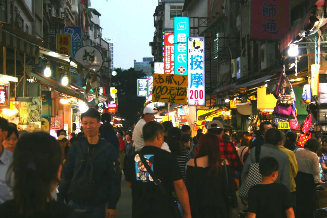
Tamsui Old Street (aka Danshui Old Street or Tamshui Old Street) is a street in Tamsui District of New Taipei famous for its delicious food and historical atmosphere. It is one of the most popular and well known old streets in all of Taiwan. Some local delicacies here include A-gei, iron eggs, fried squid, and other seafood.
Background: Tamsui Old Street developed alongside the Tamsui Harbor, which was opened in 1860 during the Qing Dynasty as part of the Treaty of Tientsin which ended the Second Opium War. It was one of only eight ports in the entire Qing empire that was open to trade with the west. As a result, it became a focal point for trade in Taiwan. It was also the western terminus of the Danlan Old Trail, which was a network of roads and trails that sent tea and other goods from Yilan to Tamsui. It remained an important port until it started to silt in during the 1900s, and after the construction of Keelung Harbor. There are also a number of important historical buildings near Tamsui Old Street such as Fort San Domingo, Hobe Fort, and others. Tamsui Old Street has always existed next to the old harbor, and recently there have been projects from the local government to improve tourism, such as widening roads and making a riverside walkway. With the completion of the Red Line MRT with its terminus in 1997 right at the edge of the old street, Tamsui became an extremely popular destination for residents in greater Taipei and remains to be so today. Hours: Every day 11 AM - 8 PM. Price: Free Tours: You can book a tour of Tamsui on TripAdvisor here, KKday here, or Klook here. You can book a tour to Taiwan's North Coast on TripAdvisor here, Klook here, or KKday here. Activities: There are many activities available around Tamsui such as, SUPing, Sand Bar Digging, Horse Riding, Lover's Tower, Sailing, Yachting, Happy Island Parent Child Gymnasium, Chi Po Lin Museum and more on TripAdvisor here, KKday here, or Klook here. Hotels in Tamsui: We have stayed at and recommend Fullon Hotel which has locations in Tamsui and Fulong near the beach (book on Booking.com here, Tripadvisor here, Agoda here, Klook here, Trip.com, Kayak here, or Hotels.com here). We have also stayed at and recommend the Yuanshan Grand Hotel, once the tallest building in Taiwan and still the most grand (book on Booking.com here, Tripadvisor here, Agoda here, Trip.com here, or Kayak here). Looking for a hotel? We recommend booking through Booking.com here, which provides the best quality selection of accommodation in Taiwan. Find out where to stay in our Taiwan hotels guide or search for the best hotel deals in Taiwan here. How to get there: By Car/Scooter: Take provincial highway 2 north from Taipei until you reach Tamsui. The old street is near the Tamsui MRT station. Parking can be hard to find, but there should be plentiful parking at Tamsui Elementary School and other places further away. Looking for scooter rental in Tamsui? You can search on Klook here or KKday here to search for options. You can also check out our scooter rental guide here. If you are looking for car rentals, you can also search Qeeq here, Klook here, or KKday here. You can also check out our car rental guide here. By MRT: Take the red line MRT north to Tamsui station and you have arrived. You can purchase a discount easy card to use on the MRT from Klook here or KKday here. You can also book an MRT travel pass on Klook here. By Bicycle: Cycling is the best way to enjoy Taiwan's landscapes if you have the time and energy. Looking for bicycle rentals in Taiwan? You can use Taiwan's many Youbike sharing stations, or search for rentals on KKday here, and search for tours on Klook here. You can also check out our Taiwan cycling guide here. Map: Please see below: 
Toucheng Township in Yilan is known for its amazing beaches, but there is much more to do here, such as visit Lanyang Museum, visit Turtle Island, enjoy seafood, traditional fishing harbors, recreational farms, hiking, cycling, surfing lessons, and much more. Here is a short guide to Toucheng, to let you know the variety of activities that you can enjoy here.
Background: Before Chinese settlers came, the area around Toucheng was inhabited by the Ketagalan Aboriginal tribe, whose language is now extinct. The name Toucheng literally means "first town" in Chinese, because it was the first settlement in Yilan, settled in the late 1700s. With the nearby Wushih and Touwei Harbors around the same time, it became the economic focal point of Yilan. However in the late 1800s and early 1900s Wushih Harbor and Touwei Harbor silted in, reducing their function. With the advent of the Japanese built Yilan railway line in the mid-1900's, as well as constant floods and continually silting of the harbors, Toucheng quickly lost its importance economically and fell into decay. After residents of Turtle Island were relocated to Daxi in Toucheng, Daxi Harbor was expanded and has become one of the largest fishing harbors in the area. Due to its close proximity to Taipei, Toucheng has become a major tourist area and may be the most popular surfing location in Taiwan. Tours and Activities: You can purchase tours and tickets for many activities in Yilan such as Su'ao Crayon Castle, Taipingshan, Turtle Island, Lanyang Museum, Toucheng Leisure Farm, Zhang Mei Ama Capybura Farm, Bambi Land, Yinong Ranch, National Center for Traditional Arts, Taxi Museum, Glamping, Camping, ATV / 4-wheeling experience, SUP / paddle boarding, Ximeng Forest Theater, Surfing, Kayaking, Horse Riding, River Tracing, River Rafting, River Tubing, Pack Rafting, Water Biking, Snorkeling, Canoeing, Shrimping and many others through Klook here or KKday here. Accommodation: Looking for a hotel? We recommend booking through Agoda here, which provides the best quality selection of accommodation on the islands. We have stayed at and recommend Ying Shih Guest House, a resort in Datong Township near Taipingshan and Fan Fan Hot Spring (you can book on Agoda here or Booking.com here), and Jiaosi Hotspring Hotel, a hotel with hot springs in each room (you can book on Agoda here, Booking.com here, Hotels.com here, Expedia here, or Trip.com here). We have also stayed at Toucheng Leisure Farm, a recreational farm and experience center in Toucheng (you can book on Agoda here, Booking.com here, Hotels.com here, Expedia here, on Klook here, or on Trip.com here). You can also book Wifi and SIM cards for Taiwan on Gigago here. Need travel insurance? Compare prices on Insubuy here. Just to let you know, if you book using the links above, we get some commission at no cost to you, and you can help support our blog. You can click here to receive $5 USD on your first Klook purchase. How to get there: By TRA: Take the TRA to any of the stations in Toucheng. You can book tickets to travel to Yilan via inter-city bus on Klook here. You can book tickets to Yialn via high speed rail (HSR) on Klook here or KKDay here. Book tickets via the normal train (TRA) on Klook here. Bicycle rental: Cycling is the best way to enjoy Taiwan's landscapes if you have the time and energy. Looking for bicycle rentals in Taiwan? You can search on KKday here and search for tours on Klook here. You can also check out our Taiwan cycling guide here. By Car: From Taipei, take National Freeway 5 to Toucheng. Be careful to note that on Sundays there are highway controls for cars travelling from Yilan to Taipei from 3 PM to 8 PM, so avoid travelling back to Taipei at that time to beat the traffic. Looking for scooter rental in Yilan? You can search Klook here or KKday here to look for options. You can also check out our scooter rental guide here. If you are looking for car rentals in Yilan, you can also search Klook here or KKDay here. You can also check out our car rental guide here. Map: See below for a map of places that are covered in this blog: 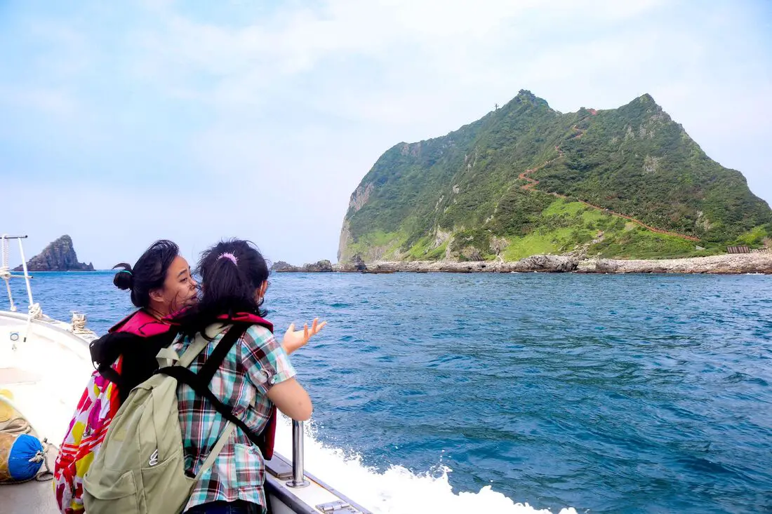
Keelung Islet is the tall, rocky island off the coast of Keelung City that has recently been reopened to tourists. The island features a trail to the lighthouse at the highest peak that provides breathtaking views of the surrounding area. Just a short trip from Taipei, and then a 20-minute boat ride, it is one of the most accessible outer islands that you can visit in Taiwan.
Background: Keelung Islet is a volcanic remnant dating back to the Pleistocene era about 1 million years ago and is part of the Ryukyu Volcanic Arc which is formed from the subduction of the Philippine Sea Plate under the Eurasian Plate. After the volcano was formed, it was slowly eroded away by wave action, creating a steep mountain peak with sides at about a 60-degree angle. The island is 182 meters tall (597 feet), 960 meters long (3139 feet), and 400 meters (1312 feet) wide. Except for crabs, birds, lizards, and insects, the island remained uninhabited until the Japanese stationed troops here during the colonization of Taiwan. After the ROC took control of Taiwan, the island continued to be a military base. In 1980, the Keelung Islet Lighthouse was completed. It was the first lighthouse in Taiwan built in an octagonal shape, and the first powered by solar power and batteries. The islet was opened to tourists in 2001, however, tourism to the island was stopped in 2014 after Typhoon Maria ravaged the island, and was closed for five years until 2019. Currently, the island is open to tourists, but you cannot stay overnight there. The only people that live on the island are members of the coast guard who stay there on a rotational basis. Tourist boats take off daily from Baodouzi Harbor from April until October, and the island is closed to tourists during the winter months due to strong northeasterly winds. The island is popular especially on weekends during the summer, but only 1200 people are allowed to visit each day, so you may have to book in advance. Hours: Boats to Keelung Islet leave at about 8 AM, with the last boats leaving at about 1 PM. Everyone has to be off the island before sundown. Each trip lasts about 3-5 hours depending on the itinerary. You can book boat tickets on Klook here or KKday here. Boats to Keelung Islet are only available from April to October due to northeasterly winds in the winter. Price: Boat trip to the island and hike to the lighthouse: about 700 NT Boat trip to the island, lighthouse, and other places such as elephant trunk rock: about 1200 NT Again, you can book tickets on Klook here or KKday here; booking on these sites is usually cheaper than buying tickets in person. When to go: Boats to Keelung Islet are only available from April to October due to northeasterly winds in the winter. If you visit from May - June you will be able to see white lily flowers, and August to September is golden spider lily season. How to get there: In order to get to Keelung Islet, you first need to make your way to Badouzi Harbor (see map below). By Car/Scooter: Drive to Keelung, then from downtown take provincial highway 2 East about 10 KM until you reach the turnoff to Badouzi Harbor, and there is some paid parking in front of the harbor. If you are looking for car rentals, you can also search Qeeq here, Klook here, or KKday here. You can also check out our car rental guide here. Looking for scooter rental in northern Taiwan? You can search on Klook here or KKday here to search for options. You can also check out our scooter rental guide here. By Train/Bus: Take the TRA to Badouzi (八斗子) station, then walk about 1 KM northwest until you reach the Badouzi Harbor. You can purchase a discount easy card to use on the MRT and buses from Klook here or KKday here. You can also book an MRT travel pass on Klook here. By Ferry: Next you have to take a boat to the island. There are multiple ferry boats running to Keelung daily from April to October. You can book tickets on Klook here or KKday here. Hotels in Keelung: We recommend Just Live Inn-Keelung and Yung Feng Hotel, which are two great quality hotels for a reasonable price in Keelung's City Center. You can book Just Live Inn-Keelung on Booking.com here, Agoda here, Klook here, Hotels.com here, Trip.com here, or Kayak here. You can book Yung Feng Hotel on Booking.com here, Agoda here, Hotels.com here, Trip.com here, Klook here, or Kayak here. Map: 
Taiwan's northern coast is an amazing, beautiful area with unique geology and rocks, lots of sandy beaches, amazing mountain views and hikes, old streets, night markets, historical sites, and much more to discover. Don't not come here.
Brief Historical Background: The sandstone that forms Northern Taiwan was created between 10 and 20 million years ago and was pushed out of the sea along with northern Taiwan thousands of years ago. Sediment under the ocean millions of years ago was uplifted thanks to the collision of the Eurasian and Philipine plates. The rocks have then been slowly eroded away by wind and water, creating odd shapes that you see today. You can see similar formations at Yehliu Geopark. What is now Keelung and Taipei was once part of Basay aborigine lands. The area around Yilan was inhabited by the Ketagalan Aboriginal tribe, whose language is now extinct. The name Yilan comes from this language. Chinese settlers from Fujian began living in the Taipei Basin during the Dutch rule in the 1600s. Keelung was first settled by the Spanish in 1626, as their first settlement in what became their rule of northern Taiwan until they were defeated by the Dutch and left Taiwan in 1642. The Qing Dynasty then ruled western Taiwan starting from the late 1600s. The capital of Taiwan was moved to Tainan. In 1891, the first train connecting Keelung and Taipei was completed. During this time, the Qing Dynasty built many forts near Keelung in response to the Opium Wars and the Sino-French War. During the Japanese Era, the capital of Taiwan was moved to Taipei and a round-island railway was completed. Currently a High-Speed Rail extension is planned for Yilan, and is expected to be completed by 2036. The northern coast of Taiwan is a popular weekend destination for the nearly 8 million people who live in the greater Taipei area. Basic Taiwan Travel Tips:
When should you go to Taiwan's Northern Coast? In my opinion, the best weather in Taipei is from March-May, and October - November, when the temperatures stay around 26 degrees Celsius and there is not as much rain. Summers are also nice, with the most sunny weather, but also hot and rainy. Winters can be cold (but not below freezing) and usually wet. Overall, there is no wrong answer as to what time of year you should visit Taipei. You will have a great time here at any time of year. Hotels on Taiwan's Northern Coast: We recommend Fullon Hotel which has locations in Tamsui and Fulong near the beach (book on Booking.com here, Tripadvisor here, Agoda here, or Hotels.com here). We have stayed at and recommend Gold Mountain Ranch, which is a horse ranch and glamping destination in Jinshan. You can book a night at Gold Mountain Ranch on Klook here. You can also check out our full blog on the ranch here. We have also stayed at and recommend Hai Xia Your Home which is right in front of Fulong Beach (book on Booking.com here, Tripadvisor here, Agoda here, or Hotels.com here). Looking for a hotel? We recommend booking through Booking.com here, which provides the best quality selection of accommodation in Taiwan. Find out where to stay in our Taiwan hotels guide or search for the best hotel deals in Taiwan here. Tours of Taiwan's Northern Coast: There are many tour itineraries that you can enjoy along Taiwan's Northern Coast that will take you to multiple destinations and arrange transportation. For more information, you can check out Tripadvisor here, KKday here, or Klook here, which are both great tour websites that can connect you with the right tour and tour guide for you. Here are some of the most popular tours of Taipei on Tripadvisor:
You can book a customized tour of Taiwan's North Coast on TripAdvisor here, Klook here, or KKday here. Attractions along Taiwan's Northern Coast: There are many attractions that you can enjoy along Taiwan's Northern Coast such as Yehliu Ocean World, Yehliu Geopark, National Museum of Marine Science and Biology, Heping Island Park, Ju Ming Museum, New Taipei Gold Museum, Futian Leisure Farm, Fort San Domingo, 13 Levels Archaeology Museum, Bat Cave, Candlestick Islet, Activities along Taiwan's Northern Coast: Don't forget that there are many activities available along Taiwan's Northern Coast such as Wakeboarding, Surfing, Speedboat Surfing, SUP / Paddle Boarding, Diving, Snorkeling Kayaking, Canoeing, Water Biking, River Tracing / Canyoneering, ATVing, Horse Riding, Archery, Tree Climbing, Glamping, Motorcycling, Motorbike Tour, Dragon Boat Racing, Shen'ao Rail Bike, and more on Tripadvisor here, Klook here, or KKday here. Just to let you know, if you book using the links above, we get some commission at no cost to you, and you can help support our blog. Some of the Klook links may not work if you are using an Ad blocker. You can click here to receive $5 USD on your first Klook purchase. How to get there: The only way to get to Taiwan is via airplane. Planes leave daily from Taipei's Songshan and Toayuan Airport. Taoyuan Airport: Taoyuan is Taiwan's largest airport and typically has cheaper flights and more flight times to choose from. It's about an hour's journey from Taoyuan Airport to the center of Taipei. You can travel via MRT, HSR, bus, or taxi to get to Taipei. You can get 30% off the Taoyuan Airport VIP lounge on KKday here. Songshan Airport: Songshan is a small airport in Taipei's city center, and can be a convenient option for people traveling within Asia. The airport is right on the Taipei MRT brown line. You can book cheap flights to Taiwan on KKday here, Trip.com here, CheapO Air here, or Kiwi here. How to get around Taiwan's Northern Coast: Northern Taiwan's transportation system is convenient and safe. There are many options you can consider to get around along Taiwan's Northern Coast below: By Train: Gets you to Keelung, Fulong, and Yilan along the north and east parts of the North Coast. Book tickets via the normal train (TRA) on Klook here. By MRT: (Mass Rapid Transit, Metro train, subway) – Easily gets you around Taipei and Tamsui. You can purchase a discount easy card to use on the MRT from Klook here or KKday here. You can also book an MRT travel pass on Klook here. By Bus: Buses run along the entire northeast coast, but they may be slow and there may not be many busses during weekdays. You can also book tickets to travel to Shifen via inter-city bus on Klook here. You can also book a Taipei Sightseeing: Hop On, Hop Off Open Top Bus on TripAdvisor here. By Taxi: You can take short rides for about 150 NT, or hire a Taxi for a day for around 150 USD. You can search for private chartered cars on KKDay here. By Car: If you are looking for car rentals, you can also search Qeeq here, Klook here, or KKday here. You can also check out our car rental guide here. By Scooter: Looking for scooter rental in northern Taiwan? You can search on Klook here or KKday here to search for options. You can also check out our scooter rental guide here. By Bicycle: Cycling is the best way to enjoy Taiwan's landscapes if you have the time and energy. Looking for bicycle rentals in Taiwan? You can use Taiwan's many Youbike sharing stations, or search for rentals on KKday here, and search for tours on Klook here. You can also check out our Taiwan cycling guide here. You can also book a cycling tour on TripAdvisor here. For more information, check out our Taiwan transportation guide here. Here is a map of the locations we will cover in this blog: 
Riding a bicycle around Taiwan may be the best way to enjoy the island. Taiwan is known as the bicycle kingdom not just because it is one of the top manufacturers of bicycles in the world, but also because the Island of Taiwan has many amazing world-class roads waiting for cyclists to discover such as hundreds of kilometers of coastline, mountains above 3000 meters, and the world's deepest marble gorge. If you are a fan of cycling, you definitely need to check out this amazing island.
Looking for bicycle rentals in Taiwan? You can search on KKday here. Looking for a bike tour of Taiwn? Search KKday here to search for options. 
Yilan is a gem on Taiwan's northeast coast. It has rugged mountains, waterfalls, a flat coastal plain, a volcanic island, hot springs, and some of the best beaches in Taiwan. In addition you can find night markets, seafood markets, museums, and much more to explore here. It is definitely worth a stop on your next trip to Taiwan.
Historical Background of Yilan: Before Chinese settlers came, the area around Yilan was inhabited by the Ketagalan Aboriginal tribe, whose language is now extinct. The name Yilan comes from this language. The town Toucheng literally means "first town" in Chinese, because it was the first settlement in Yilan, settled in the late 1700s. With the nearby Wushih and Touwei Harbors around the same time, it became the economic focal point of Yilan. However, in the late 1800s and early 1900s Wushih Harbor and Touwei Harbor silted in, reducing their function. With the advent of the Japanese-built Yilan railway line in the mid-1900's, as well as constant floods and continual silting of the harbors, Toucheng Old Street quickly lost its importance economically and fell into decay. The Japanese also built logging railways up to Taipingshan to harvest lumber. The first path between Yilan and Hualien was a trail built in the Qing Dynasty that was completed in 1876, in order for the Qing to better control aboriginal peoples on the east coast. Later after Japan took control of Taiwan, they widened the path and built 9 bridges and 14 tunnels along the way, making it drivable for cars (one way only) by 1932. Because much of the road was next to cliffs that underwent constant landslides, it was considered one of the most dangerous roads in the world at the time. In the 1980s the ROC government further widened the road, and the two-lane highway was completed in 1990. In 2020, the section of road between Su'ao and Dong'ao was bypassed by a tunnel. Currently Yilan has a population of over 450,000. An High-Speed Rail extension is planned for Yilan, and is expected to be completed by 2036. When to go? The best weather in Yilan lasts from about March-November. During winter months there is constant rain due to the northeasterly winds. How get to Yilan? You can book tickets to travel to Yilan via inter-city bus on Klook here. You can book tickets to Yialn via high speed rail (HSR) on Klook here or KKDay here. Book tickets via the normal train (TRA) on Klook here. How to get around in Yilan? As always, we recommend renting a scooter as the best way to see Taiwan. However, you can also a great deal of Yilan by taking the TRA train, inter-city bus, or local bus. Getting around in a car is also a convenient option as there is plenty of parking pretty much everywhere in this less crowded county. Scooter Rental: Looking for scooter rental in Yilan? You can search Klook here or KKday here to look for options. You can also check out our scooter rental guide here. Car Rental: If you are looking for car rentals in Yilan, you can also search Klook here or KKDay here. You can also check out our car rental guide here. Bicycle Rental: Cycling is the best way to enjoy Taiwan's landscapes if you have the time and energy. Looking for bicycle rentals in Taiwan? You can search on KKday here and search for tours on Klook here. You can also check out our Taiwan cycling guide here. Tours and Activities: You can purchase tours and tickets for many activities in Yilan such as Su'ao Crayon Castle, Taipingshan, Turtle Island, International Children's Festival, Lanyang Museum, Toucheng Leisure Farm, Zhang Mei Ama Capybura Farm, Bambi Land, Yinong Ranch, National Center for Traditional Arts, Taxi Museum, Glamping, Camping, ATV / 4-wheeling experience, SUP / paddle boarding, Ximeng Forest Theater, Surfing, Kayaking, Horse Riding, River Tracing, River Rafting, River Tubing, Pack Rafting, Water Biking, Snorkeling, Canoeing, Shrimping and many others through Klook here or KKday here. Accommodation: We have stayed at and recommend Ying Shih Guest House, a resort in Datong Township near Taipingshan and Fan Fan Hot Spring (you can book on Agoda here or Booking.com here), and Jiaosi Hotspring Hotel, a hotel with hot springs in each room (you can book on Agoda here, Booking.com here, Hotels.com here, Expedia here, or Trip.com here). We have also stayed at Toucheng Leisure Farm, a recreational farm and experience center in Toucheng (you can book on Agoda here, Booking.com here, Hotels.com here, Expedia here, on Klook here, or on Trip.com here). We recommend booking through Agoda here, which provides the best quality selection of accommodation on the islands. Find out where to stay in our Taiwan hotels guide or search for the best hotel deals in Taiwan here. You can also book Wifi and SIM cards for Taiwan on Gigago here. Need travel insurance? Compare prices on Insubuy here. Just to let you know, if you book using the links above, we get some commission at no cost to you, and you can help support our blog. You can click here to receive $5 USD on your first Klook purchase. Map: You can find a map of places we will cover in this blog below: 
Yilan International Children's Folklore and Folkgame Festival (宜蘭國際童玩藝術節) is one of the largest children's festivals in Taiwan, occurring every year during summer break along the Dongshan River in Yilan. It features a large outdoor waterpark as well as musical performances, exhibitions, games, and cultural events. It has become a yearly tradition for many families in northern Taiwan.
Background: The festival first began in 1996 and has continued every year, except for 2008-2009 due to lack of funds, in 2003 because of SARS, and in 2020 due to COVID. The completion of the Hsueshan Tunnel in 2006 made it much easier for large amounts of people to travel quickly from Taipei to Yilan. The large event attracts many visitors from Taipei. During summer weekdays and weekends the venue can be expected to be totally packed with visitors. Hours: 10 AM to 9 PM (pool area closes at 6 PM), starting from the beginning of July to mid-August every summer. In 2024 the festival runs from July 6th to August 18th. Price: 350 NT on weekends and 250 NT on weekdays 50 NT parking fee for cars 20 NT parking fee for scooters You can book tickets for a discount on Klook here or book a day tour on KKday here. Website: https://www.yicfff.tw/index.php?lang=5tKpKqHPsMZQ82iPyZj4TQ Tours and Activities: You can purchase tours and tickets for many activities in Yilan such as Su'ao Crayon Castle, Taipingshan, Turtle Island, Lanyang Museum, Toucheng Leisure Farm, Zhang Mei Ama Capybura Farm, Bambi Land, Yinong Ranch, National Center for Traditional Arts, Taxi Museum, Glamping, Camping, ATV / 4-wheeling experience, SUP / paddle boarding, Ximeng Forest Theater, Surfing, Kayaking, Horse Riding, River Tracing, River Rafting, River Tubing, Pack Rafting, Water Biking, Snorkeling, Canoeing, Shrimping and many others through Klook here or KKday here. Accommodation: Looking for a hotel? We recommend booking through Agoda here, which provides the best quality selection of accommodation on the islands. We have stayed at and recommend Ying Shih Guest House, a resort in Datong Township near Taipingshan and Fan Fan Hot Spring (you can book on Agoda here or Booking.com here), and Jiaosi Hotspring Hotel, a hotel with hot springs in each room (you can book on Agoda here or Booking.com here). We have also stayed at Toucheng Leisure Farm, a recreational farm and experience center in Toucheng (you can book on Agoda here, Booking.com here, or on Klook here). How to get there: By car/scooter: From National Highway 5 in Yilan, take provincial highway 7 east to Dongshan River Water Park. Looking for scooter rental in Yilan? You can search Klook here or KKday here to look for options. You can also check out our scooter rental guide here. If you are looking for car rentals in Yilan, you can also search Klook here or KKDay here. You can also check out our car rental guide here. By bus: From Luodong TRA station, take bus GR21 to Dongshan River Water Park. You can book tickets to travel to Yilan via inter-city bus on Klook here. You can book tickets to Yialn via high speed rail (HSR) on Klook here or KKDay here. Book tickets via the normal train (TRA) on Klook here. Bicycle rental: Cycling is the best way to enjoy Taiwan's landscapes if you have the time and energy. Looking for bicycle rentals in Taiwan? You can search on KKday here and search for tours on Klook here. You can also check out our Taiwan cycling guide here. Map: Please see below: 
This month marks the 10th anniversary of this blog, so to celebrate I am making a blog tracing back our first round-island trip lasting 14 days and 13 nights made in 2014. During this journey we rented a car in Taipei, and circled Taiwan clockwise, visiting Taroko Gorge, Kenting, Xiaoliuqiu, Alishan, Sun Moon Lake, and many more places along the way. I am the kind of guy who likes to bask in nostalgia, but also I hope that laying out this experience in the open as well as the lessons we learned about travel in Taiwan along the way (and what I know now in 2024) will be helpful to other foreigners coming to Taiwan.
Some background on why this trip happened: This was not our first trip to Taiwan. Scott and I had been Latter-day Saint missionaries in Taiwan from 2011 to 2012 in the Taichung Mission, which covers Taichung to Pingtung but nothing north or east of that. We still had a lot of friends in Taiwan that we missed, we missed Taiwanese food, and there were the entire north and east parts of the island for us to explore. We decided it would be a once-in-a-lifetime opportunity to tour Taiwan now because later on in our lives we would likely have work and family obligations that would not allow us to take a 14-day trip around Taiwan. Being poor college students at the time, we had a very limited budget (for reference, I was making 700 USD a month as a janitor and I could only save about half of that after rent and food). Originally another friend planned to come with us, but he backed out because he got married. Scott's brother Matt decided to come along too. Just so you know, Scott and I know Chinese, but Matt doesn't. It makes traveling easier to know the language but you can still get by in Taiwan without it. The Plane Ride: We took the cheapest flight available on Shenzhen Airlines, which had many flights for cheap to the US at the time. For 700 USD we bought a round trip from LA to Beijing to Taipei and back. Renting a car in Taiwan: Before we began our trip, we planned on rounding the island by Scooter. This can be a fun way to explore Taiwan. As a side note, you can book a Motorcycling experience on Klook here, or a half-day Motorbike Tour on KKday here. If you are looking for a multi-day, in-depth tour of Taiwan via motorbike, we recommend contacting [email protected] who schedules regular 10-day motorbike tours of Taiwan. The tour guide is a long-term expat in Taiwan who has been giving riding tours of Taiwan for 16 years now. You can also check out our scooter rental guide here. After crunching the numbers, we figured that we could rent a car for just as cheap as three scooters, and we wouldn't have to worry about rain or luggage. A scooter would be 300 NT per day, and for three people 900 NT per day, but we found a car rental place that would rent us a small Nissan March for 700 NT a day (that car company was called Good Cars 固得汽車 in Zhonghe, you can find their information in our Taiwan Car Rental Guide here). After arriving at Taoyuan International Airport, we took a bus to Taipei and made our way to Zhonghe at a friend's house and picked up the rental car. At the end of the trip, we found the price was a few thousand NT more than we expected because of highway tolls (about 1.5 NT per kilometer). SIM Card: I bought a pre-paid SIM card from Taiwan Mobile for 500 TWD that lasted the whole trip. I think it was only a few GB of data, but I had a crappy phone and was not using much data. Map: Check out a map of places we visited on this trip below: 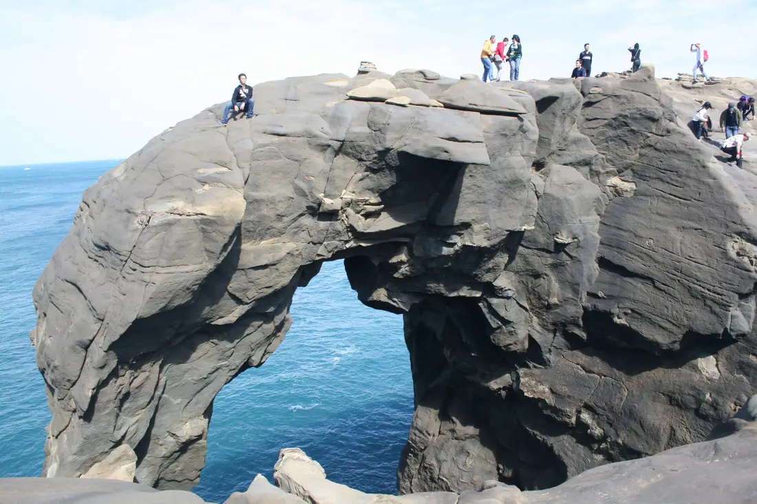
Elephant Trunk Rock was a rock shaped like its name in the Shenao area of Ruifang District, New Taipei City. There are also many interesting rock formations in the area. It was one of the most recognizable rock formations on the north coast and a popular location for, kayakers, snorkelers, and Instagrammers.
Elephant Trunk Rock eroded away and fell into the sea on December 16th, 2023. You can still visit for great views here, but the elephant trunk is gone. Background: The sandstone and sedimentary that forms the Elephant Rock formation was created between 10 and 20 million years ago, and was pushed out of the sea along with northern Taiwan thousands of years ago. The Elephant's head was formed by easily eroding sandstone, with the area under the trunk being eroded away by the sea and waves. Elephant Rock is so named because it looks like an elephant. The area around Elephant Rock was a protected military base until the year 2000, after which civilians were allowed to freely visit. Kayaking and Snorkeling are also popular activities near the Elephant Rock. Hours: 24/7 Price: Free Tours and Activities: At Elephant Rock there are many activities available to enjoy such as kayaking, canoeing, snorkeling, SUP / paddle boarding, water biking, and more activities which you can book on Klook here or KKday here. Hotels on Taiwan's Northern Coast: We recommend Fullon Hotel which has locations in Tamsui and Fulong near the beach (book on Booking.com here, Tripadvisor here, Agoda here, or Hotels.com here). We have stayed at and recommend Gold Mountain Ranch, which is a horse ranch and glamping destination in Jinshan. You can book a night at Gold Mountain Ranch on Klook here. You can also check out our full blog on the ranch here. We have also stayed at and recommend Hai Xia Your Home which is right in front of Fulong Beach (book on Booking.com here, Tripadvisor here, Agoda here, or Hotels.com here). Looking for a hotel? We recommend booking through Booking.com here, which provides the best quality selection of accommodation in Taiwan. Find out where to stay in our Taiwan hotels guide or search for the best hotel deals in Taiwan here. How to get there: By Car/Scooter: Drive to Keelung, then from downtown take provincial highway 2 east about 10 KM until you reach the Shenziao harbor, and there is some paid parking if you drive to the very end, which will put you closest to Elephant Trunk Rock. If you are looking for car rentals, you can also search Qeeq here, Klook here, or KKday here. You can also check out our car rental guide here. Looking for scooter rental in northern Taiwan? You can search on Klook here or KKday here to search for options. You can also check out our scooter rental guide here. By Train/Bus: Take the TRA to Badouzi (八斗子) station, then walk about 1 KM east until you reach the elephant rock on the coast. Book tickets via the normal train (TRA) on Klook here. You can purchase a discount easy card to use on the MRT and buses from Klook here or KKday here. You can also book an MRT travel pass on Klook here. By Bicycle: Cycling is the best way to enjoy Taiwan's landscapes if you have the time and energy. Looking for bicycle rentals in Taiwan? You can use Taiwan's many Youbike sharing stations, or search for rentals on KKday here, and search for tours on Klook here. You can also check out our Taiwan cycling guide here. You can also book a cycling tour on TripAdvisor here. For more information, check out our Taiwan transportation guide here. Map: Please see below: 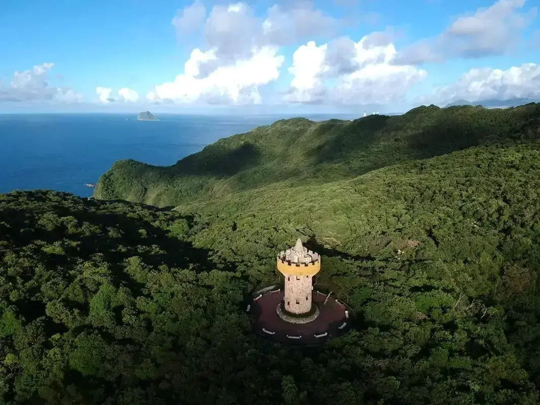
Lover's Tower, which is about a ten hike through the woods from Lover's Lake. It is one of the best spots to enjoy the scenery on Taiwan's Northern Coast. It is definitely a must-visit on your next trip to Keelung.
This blog is about the Lover's Tower in Keelung. For more information about Lover's Tower at Tamsui Fisherman's Wharf, click here. Background: The name "Lovers Lake" comes from the fact that there are actually two lakes, one larger and one smaller, so they are like a couple in love. The sandstone that forms the area was created between 10 and 20 million years ago and was pushed out of the sea along with northern Taiwan thousands of years ago. In the past, the area was run by a private company, which went out of business. Recently the Keelung City government has taken over control and has installed a trail that circles the lake. There is also a suspension bridge, windmill, and stone tower overlooking the lake. Nearby you can hike to Dawulun Fort or Eagle Rock which provides great views of the north coast. Currently, the lake is popular with hikers and Instagrammers, as well as wedding photographers. On the weekends it can get quite busy and parking can be hard to find. Hours: 24/7 Price: Free Tours: You can book a tour to Lover's Tower on KKday here. Activities: Don't forget that there are many activities available along Taiwan's Northern Coast such as Yachting, Fishing, Surfing, SUP / Paddle Boarding, Diving, Snorkeling Kayaking, Canoeing, Water Biking, River Tracing / Canyoneering, Glamping, Motorcycling, Motorbike Tour, Shen'ao Rail Bike, Night Fishing, Instagram Tour, Metaverse VR experience, Seaside Picnic, and more on Tripadvisor here, Klook here, or KKday here. Hotels in Keelung: We recommend Just Live Inn-Keelung and Yung Feng Hotel, which are two great quality hotels for a reasonable price in Keelung's City Center. You can book Just Live Inn-Keelung on Booking.com here, Agoda here, Klook here, Hotels.com here, Trip.com here, or Kayak here. You can book Yung Feng Hotel on Booking.com here, Agoda here, Hotels.com here, Trip.com here, Klook here, or Kayak here, How to get there: By car/scooter: Take Provincial highway northwest out of Keelung, and take a right on Jijin First Road toward Keelung Chang Kung Hospital. The Lover's Lake parking lot is at the top of the hill before the road turns into one lane. There is limited parking, and you may have to park further away. The trail is not wheelchair or stroller friendly. However, there is always plenty of scooter parking. If you are looking for car rentals, you can also search Qeeq here, Klook here, or KKday here. You can also check out our car rental guide here. Looking for scooter rental in northern Taiwan? You can search on Klook here or KKday here to search for options. You can also check out our scooter rental guide here. By Bicycle: Cycling is the best way to enjoy Taiwan's landscapes if you have the time and energy. Looking for bicycle rentals in Taiwan? You can use Taiwan's many Youbike sharing stations, or search for rentals on KKday here, and search for tours on Klook here. You can also check out our Taiwan cycling guide here. You can also book a cycling tour on TripAdvisor here. For more information, check out our Taiwan transportation guide here. By Bus: Unfortunately, there are no buses that directly get there, so you will have to walk from Provincial Highway 2, or take a taxi. You can purchase a discount easy card to use on the MRT and buses from Klook here or KKday here. You can also book an MRT travel pass on Klook here. Map: Please see below: 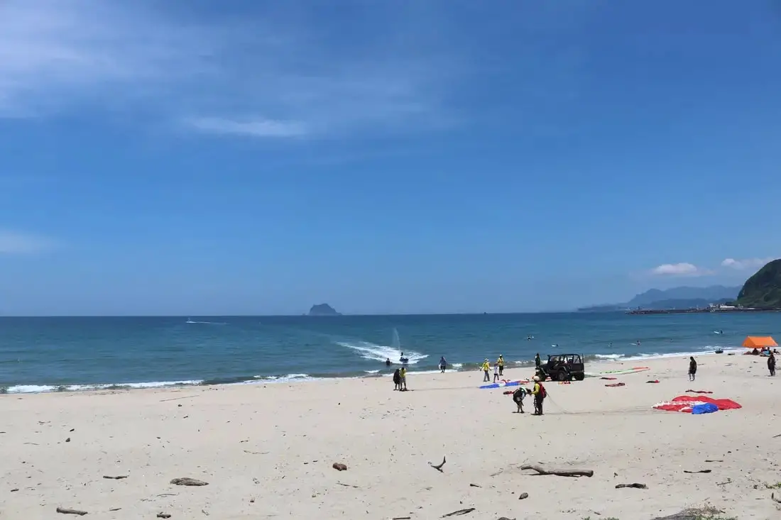
Wanli Beach (aka Feitsuiwan, Emerald Bay, or Green Bay) is a popular beach along the northern Coast. Paragliding is the most popular activity at this beach but people also swim and surf here too. Nearby you can also check out the UFO house village. It is definitely worth a stop on your next trip to Taiwan's Northern Coast.
Background: At the time during martial law, Wanli Beach (Feitsui Bay) was one of the few places where American servicemen could enjoy a beach vacation, as most beaches were closed off at the time. The UFO house village was created in the 1970s by a Taiwan construction company. These UFO houses had these servicemen in mind. However, a slowing economy and the severing of official diplomatic ties with the USA prevented the area from taking off, and the UFO resort town fell into decay. For a more complete historical background on this area, check out this blog by Josh Ellis. Common Courtesy When Visiting:
Hours: 24/7 Price: Free Activities: You can book a SUP / Paddle Board experience at Feitsui Bay on KKday here. Tours: You can book a tour to Taiwan's North Coast on TripAdvisor here, Klook here, or KKday here. You can book a Private Laomei Green Reef Day Tour from Taipei on TripAdvisor here or KKday here. Hotels on Taiwan's Northern Coast: We recommend Fullon Hotel which has locations in Tamsui and Fulong near the beach (book on Booking.com here, Agoda here, or Kayak here). We have also stayed at and recommend Hai Xia Your Home which is right in front of Fulong Beach (book on Booking.com here, Agoda here, or Kayak here). Looking for a hotel? We recommend booking through Booking.com here, which provides the best quality selection of accommodation in Taiwan. Find out where to stay in our Taiwan hotels guide or search for the best hotel deals in Taiwan here. How to get there: By Bus: There are many buses that pass the area. You'll want to get off at Green Bay (翡翠灣). You can purchase a discount easy card to use on the MRT and buses from Klook here or KKday here. You can also book an MRT travel pass on Klook here. By Car/Scooter: Take Provincial Highway 2 west out of Keelung, and keep going until you reach the Howard Green Bay Resort. If you are looking for car rentals, you can also search Qeeq here, Klook here, or KKday here. You can also check out our car rental guide here. Looking for scooter rental in northern Taiwan? You can search on Klook here or KKday here to search for options. You can also check out our scooter rental guide here. By Bicycle: Cycling is the best way to enjoy Taiwan's landscapes if you have the time and energy. Looking for bicycle rentals in Taiwan? You can use Taiwan's many Youbike sharing stations, or search for rentals on KKday here, and search for tours on Klook here. You can also check out our Taiwan cycling guide here. You can also book a cycling tour on TripAdvisor here. For more information, check out our Taiwan transportation guide here. Map: 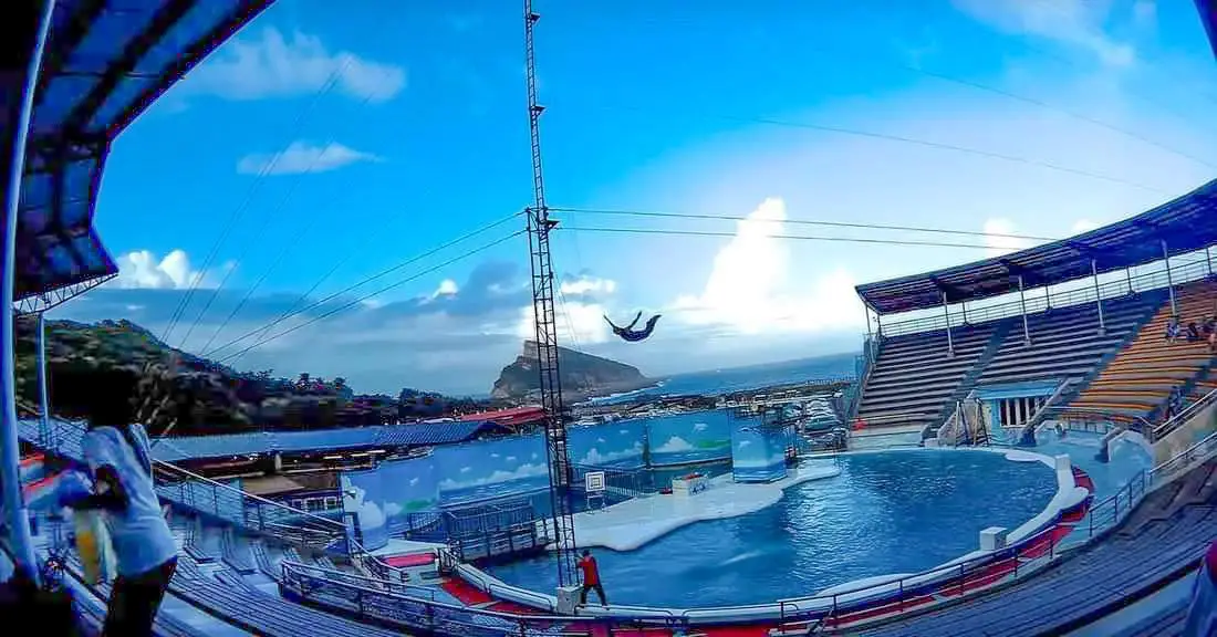
Yehliu Ocean World is the largest aquarium in northern Taiwan and has one of the few outdoor sea life amphitheaters in Taiwan. The facility features an indoor aquarium and an outdoor show that is geared toward children. It is an unmissable stop on your next trip to Taiwan's north coast.
Background: The sandstone that forms the Yehliu Formation was created between 10 and 20 million years ago and was pushed out of the sea along with northern Taiwan thousands of years ago. The Queen's head is formed by two layers of sandstone, one soft eroding layer on the bottom and a harder layer on top. This kind of sandstone formation can be seen around the world and is known as a hoodoo. The Queen's head was named after Queen Elizabeth I because it is thought to look like her. The head is eroding .2 to .5 CM per year and is expected to fall at any time! The name "Yehliu" comes from the Spanish name for the area "Putno Diablos" which was then also used by the Dutch, and transliterated by the Chinese settlers in the area as "Yehliu" in Chinese. Yehliu Ocean World is the largest aquarium in northern Taiwan and has one of the few outdoor sea life amphitheaters in Taiwan. The facility features an indoor aquarium and an outdoor show that is geared toward children. Hours: Yehliu Geopark: 8 AM to 5 PM in winter (tickets not sold after 4:30) 8 AM to 6 PM in summer (tickets not sold after 5:30) Yehliu Ocean World: 9 AM to 5 PM Price: Yehliu Geopark: 120 NT per person. You can book discount tickets to Yehliu Geopark on Klook here and KKday here. Yehliu Ocean World: 450 NT per person. You can book discount tickets to Yehliu Ocean World on Klook here and KKday here. You can also book tickets to the Yehliu Ocean World Parent-Child playground on Klook here. Tours: You can book a tour to Yehliu on Klook here, TripAdvisor here, or KKday here. Activities along Taiwan's Northern Coast: Don't forget that there are many activities available along Taiwan's Northern Coast such as Wakeboarding, Surfing, Speedboat Surfing, SUP / Paddle Boarding, Diving, Snorkeling Kayaking, Canoeing, Water Biking, River Tracing / Canyoneering, ATVing, Horse Riding, Archery, Tree Climbing, Glamping, Motorcycling, Motorbike Tour, Dragon Boat Racing, Shen'ao Rail Bike, and more on Tripadvisor here, Klook here, or KKday here. Hotels on Taiwan's Northern Coast: We recommend Fullon Hotel which has locations in Tamsui and Fulong near the beach (book on Booking.com here, Tripadvisor here, Agoda here, or Hotels.com here). We have stayed at and recommend Gold Mountain Ranch, which is a horse ranch and glamping destination in Jinshan. You can book a night at Gold Mountain Ranch on Klook here. You can also check out our full blog on the ranch here. We have also stayed at and recommend Hai Xia Your Home which is right in front of Fulong Beach (book on Booking.com here, Tripadvisor here, Agoda here, or Hotels.com here). Looking for a hotel? We recommend booking through Booking.com here, which provides the best quality selection of accommodation in Taiwan. Find out where to stay in our Taiwan hotels guide or search for the best hotel deals in Taiwan here. How to get there: By Bus: There are inter-city buses that leave hourly from Taipei Main Station and Taipei City Hall to Yehliu. You can purchase a discount easy card to use on the MRT and buses from Klook here or KKday here. You can also book an MRT travel pass on Klook here. By Car/Scooter: Take Provincial highway 2 west out of Keelung, and keep going until you reach Wanli. The turnoff to Yehliu comes right after Wanli beach. If you are looking for car rentals, you can also search Qeeq here, Klook here, or KKday here. You can also check out our car rental guide here. Looking for scooter rental in northern Taiwan? You can search on Klook here or KKday here to search for options. You can also check out our scooter rental guide here. By Bicycle: Cycling is the best way to enjoy Taiwan's landscapes if you have the time and energy. Looking for bicycle rentals in Taiwan? You can use Taiwan's many Youbike sharing stations, or search for rentals on KKday here, and search for tours on Klook here. You can also check out our Taiwan cycling guide here. You can also book a cycling tour on TripAdvisor here. For more information, check out our Taiwan transportation guide here. Map: Please see below: 
Jinshan Beach 金山海濱浴場 (aka Xiaoliao Wan 下寮灣) is a nice stretch of beach near Jinshan Old Street. On the other side of the beach is a rocky shoreline popular for hikers called the "Jinshan Shuiwei Port Mysterious Coast 神秘海岸" which you can also check out.
Background: The first people to live in the Jinshan Area were plains indigenous peoples. The name "Jinabaoli" comes from the Chinese transliteration of the indigenous name of the place. Chinese people began to settle here during the late Ming Dynasty, coming mainly from Fujian, and even more came to settle here during the Qing Dynasty. During the Japanese occupation of Taiwan, a road was built to connect Jinshan to Keelung and Tamsui, making it easier for people to visit. This road was improved in the ROC period to become Provincial Highway 2. Jinshan now has a population of about 22,000 people. Currently Jinshan Old Street is a popular place to visit for day-trippers from Taipei. Hours: 24/7 Price: Free Tours: You can book a walking tour to Jinshan Old Street on Klook here or KKday here. Activities: Don't forget that there are many activities available along Taiwan's Northern Coast such as Wakeboarding, Surfing, Speedboat Surfing, SUP / Paddle Boarding, Diving, Snorkeling Kayaking, Canoeing, Water Biking, River Tracing / Canyoneering, ATVing, Horse Riding, Archery, Tree Climbing, Glamping, Motorcycling, Motorbike Tour, Dragon Boat Racing, Shen'ao Rail Bike, and more on Tripadvisor here, Klook here, or KKday here. Hotels on Taiwan's Northern Coast: We have stayed at and recommend Gold Mountain Ranch, which is a horse ranch and glamping destination in Jinshan. You can book a night at Gold Mountain Ranch on Klook here. You can also check out our full blog on the ranch here. Looking for a hotel? We recommend booking through Booking.com here, which provides the best quality selection of accommodation in Taiwan. Find out where to stay in our Taiwan hotels guide or search for the best hotel deals in Taiwan here. How to get there: By Car/Scooter: From Keelung, take Provincial Highway 2 north along the coast until you reach Jinshan. The beach is up the road not far from the old street. If you are looking for car rentals, you can also search Qeeq here, Klook here, or KKday here. You can also check out our car rental guide here. Looking for scooter rental in northern Taiwan? You can search on Klook here or KKday here to search for options. You can also check out our scooter rental guide here. By Bicycle: Cycling is the best way to enjoy Taiwan's landscapes if you have the time and energy. Looking for bicycle rentals in Taiwan? You can use Taiwan's many Youbike sharing stations, or search for rentals on KKday here, and search for tours on Klook here. You can also check out our Taiwan cycling guide here. You can also book a cycling tour on TripAdvisor here. For more information, check out our Taiwan transportation guide here. By Bus: There are buses that leave from Taipei City Hall station to Jinshan hourly. The ride takes about an hour. You can purchase a discount easy card to use on the MRT and buses from Klook here or KKday here. You can also book an MRT travel pass on Klook here. Map: Please see below: 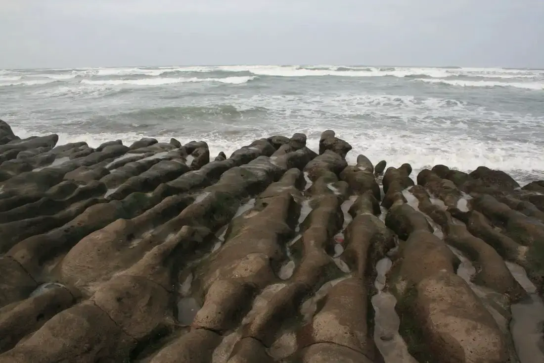
Laomei Green Reef is a popular tourist destination just a kilometer away up the coast from Baishawan, past Fugui Cape. If you catch the reef at a super low tide, the rocks will be covered in green algae.
Background: Laomei Green Reef was formed roughly 800,000 years ago by volcanoes spewing lava into the ocean creating Fuigui Cape. Later, Alagae began growing on the rocks. Now at low tide, the rocks look like they are a "green reef," hence their name. Because of its proximity to Taipei, there are sure to be many visitors, and because Taipei has the highest concentration of foreigners, be prepared to see a lot of other foreigners as well. Price: Free Parking: Free. There is a parking lot in front of the main entrance. If this is full, you can park along the road next to it. Tours: You can book a Private Laomei Green Reef Day Tour from Taipei on TripAdvisor here or KKday here. You can book a tour to Taiwan's North Coast on TripAdvisor here, Klook here, or KKday here. Activities: Don't forget that there are many activities available along Taiwan's Northern Coast such as Wakeboarding, Surfing, Speedboat Surfing, SUP / Paddle Boarding, Diving, Snorkeling Kayaking, Canoeing, Water Biking, River Tracing / Canyoneering, ATVing, Horse Riding, Archery, Tree Climbing, Glamping, Motorcycling, Motorbike Tour, Dragon Boat Racing, Shen'ao Rail Bike, and more on Tripadvisor here, Klook here, or KKday here. Hotels on Taiwan's Northern Coast: We recommend Fullon Hotel which has locations in Tamsui and Fulong near the beach (book on Booking.com here, Tripadvisor here, Agoda here, or Hotels.com here). We have also stayed at and recommend Hai Xia Your Home which is right in front of Fulong Beach (book on Booking.com here, Tripadvisor here, Agoda here, or Hotels.com here). Looking for a hotel? We recommend booking through Booking.com here, which provides the best quality selection of accommodation in Taiwan. Find out where to stay in our Taiwan hotels guide or search for the best hotel deals in Taiwan here. How to Get There: By Bus: Take Keelung bus from either Danshui MRT station or Keelung TRA station. You can also take the yellow and white North Coast Shuttle Bus to Baishawan station. You can purchase a discount easy card to use on the MRT and buses from Klook here or KKday here. You can also book an MRT travel pass on Klook here. By Car/Scooter: Drive on Provincial Highway 2 out of Danshui to the northeast, or out of Keelung to the northwest. The beach area is near Sanzhi District 三芝區. If you are looking for car rentals, you can also search Qeeq here, Klook here, or KKday here. You can also check out our car rental guide here. Looking for scooter rental in northern Taiwan? You can search on Klook here or KKday here to search for options. You can also check out our scooter rental guide here. By Bicycle: Cycling is the best way to enjoy Taiwan's landscapes if you have the time and energy. Looking for bicycle rentals in Taiwan? You can use Taiwan's many Youbike sharing stations, or search for rentals on KKday here, and search for tours on Klook here. You can also check out our Taiwan cycling guide here. You can also book a cycling tour on TripAdvisor here. For more information, check out our Taiwan transportation guide here. Map: 
Jinshawan (aka Golden Bay) is one of the nicest beaches in northern Taiwan. The sand is golden, the water shallow (and warm in the summer), and it is relatively well kept and clean. Due to its lack of public transportation and small size, it sees not so many visitors compared to other beaches in the area. Swimming, sunbathing, surfing, and kite surfing are all popular activities at this beach.
Background: Jinshawan (literally Gold Sand Bay) was formed thousands years ago by the collision of the Philippine and Eurasian Plates. Because of its small size and with no other attractions nearby, it is often overlooked as a beach destination. Price: Free Hours: 24/7 Tours and Activities: You can book a Stand Up Paddle Board experience at Jinshawan on Klook here or KKday here. You can book a tour to Taiwan's North Coast on TripAdvisor here, Klook here, or KKday here. Hotels on Taiwan's Northern Coast: We recommend Fullon Hotel which has locations in Tamsui and Fulong near the beach (book on Booking.com here, Tripadvisor here, Agoda here, or Hotels.com here). We have also stayed at and recommend Hai Xia Your Home which is right in front of Fulong Beach (book on Booking.com here, Tripadvisor here, Agoda here, or Hotels.com here). Looking for a hotel? We recommend booking through Booking.com here, which provides the best quality selection of accommodation in Taiwan. Find out where to stay in our Taiwan hotels guide or search for the best hotel deals in Taiwan here. How to Get There: By Bus: Take bus 1811 from Taipei bus station to Golden Bay stop. By Car: Drive on provincial highway 2 out of Keelung to the northeast. The beach area is between Longdong and Ao'di. 
Maiyanshan is a small area on the northeast coast with aquaculture farms. There are interesting rock formations along the beach, and usually large waves here which are mesmerizing to watch. This place also has a few seafood restaurants and is worth a stop on your next trip to the northern coast.
Background: Meiyanshan (literally beautiful waves mountain) was formed thousands years ago by the collision of the Philippine and Eurasian Plates. The seaside area is named after Meiyan Mountain which watches over it. Because of its small size and with no other attractions nearby, it is often overlooked as a seaside destination. Price: Free Hours: 24/7 Tours and Activities: You can book a Stand Up Paddle Board experience at Jinshawan on Klook here or KKday here. You can book a tour to Taiwan's North Coast on TripAdvisor here, Klook here, or KKday here. Hotels on Taiwan's Northern Coast: We recommend Fullon Hotel which has locations in Tamsui and Fulong near the beach (book on Booking.com here, Tripadvisor here, Agoda here, or Hotels.com here). We have also stayed at and recommend Hai Xia Your Home which is right in front of Fulong Beach (book on Booking.com here, Tripadvisor here, Agoda here, or Hotels.com here). Looking for a hotel? We recommend booking through Booking.com here, which provides the best quality selection of accommodation in Taiwan. Find out where to stay in our Taiwan hotels guide or search for the best hotel deals in Taiwan here. How to Get There: By Bus: Take bus 1811 from Taipei bus station to Meiyanshan stop. You can purchase a discount easy card to use on the MRT and buses from Klook here or KKday here. You can also book an MRT travel pass on Klook here. By Car: Drive on provincial highway 2 out of Keelung to the northeast. The beach area is between Longdong and Ao'di. If you are looking for car rentals, you can also search Qeeq here, Klook here, or KKday here. You can also check out our car rental guide here. Looking for scooter rental in northern Taiwan? You can search on Klook here or KKday here to search for options. You can also check out our scooter rental guide here. By Bicycle: Cycling is the best way to enjoy Taiwan's landscapes if you have the time and energy. Looking for bicycle rentals in Taiwan? You can use Taiwan's many Youbike sharing stations, or search for rentals on KKday here, and search for tours on Klook here. You can also check out our Taiwan cycling guide here. You can also book a cycling tour on TripAdvisor here. For more information, check out our Taiwan transportation guide here. Map: Please see below: 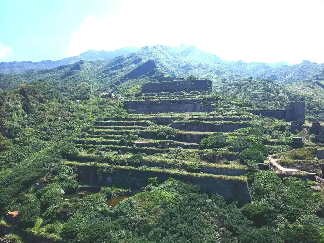
The thirteen levels smelter, also known as "Shuinandong Smelter 水南洞選練厰" or Potala Palace of Mountain Mines, was built by the Japanese and abandoned in the 1980s. Nowadays it is one of the most popular abandoned sites in Taiwan.
Historical Background: In 1890 during the Qing Dynasty, gold was found in the Keelung River during the construction of Taiwan's first railroad, which led to a small gold rush. Gold seams were eventually found in the mountains behind Jiufen around what is today Jinguashi. The name Jinguashui (金瓜石 Jīnguāshí), literally meaning "Gold Gourd Stone" comes from the shape of the nearby Keelung Mountain, which resembled a Pumpkin "Nánguā 南瓜" to early settlers, and the fact that early gold miners found lots of little gold seams resembling small gourds. After Taiwan was colonized by the Japanese in 1895, the Japanese quickly took control of the mines at Jinguashi, banning locals from owning mining rights. They quickly found many more copper and gold seams, and Jinguashi became the number one gold mine in the Japanese empire. During WWI, the mine came upon difficult times, and mining rights were passed to what is now Japan Energy, who built the 13 level complex that sits abandoned today. By 1938 it had become the most profitable gold mine in Asia, and population grew to over 80,000. During WWII, the mining operations switched from gold to copper, and the area was used as a POW camp. After the ROC took Taiwan, the mines were used mainly for copper, as the cost of refining gold was too high. The Chalet built for the crown prince of Japan at Jinguashi was later used by Chiang Kai-shek. After worldwide copper prices collapsed in the 1980s, the mine shut down for good in 1987. After that, people moved out of the town, and Jinguashi has a population of just about 2,000 people. Later mining initiatives have been met with strong criticism from environmentalists. In 2004, the New Taipei City Gold Mine Museum was completed, using several abandoned mining sites near Jinguashi, making it a popular tourist attraction in the area. Gold Mine Museum Hours: 9:30 AM to 5 PM, closed Mondays Gold Mine Museum Price: 80 NT per person (Free for New Taipei Residents) You can book discount tickets to the New Taipei Gold Mine Museum on Klook here or KKday here. Tours: You can book a tour to the 13 Levels Ruins on KKday here. Hotels near Jinguashi: We recommend Fullon Hotel which has locations in Tamsui and Fulong near the beach (book on Booking.com here, Tripadvisor here, Agoda here, or Hotels.com here). We have stayed at and recommend Gold Mountain Ranch, which is a horse ranch and glamping destination in Jinshan. You can book a night at Gold Mountain Ranch on Klook here. You can also check out our full blog on the ranch here. We have also stayed at and recommend Hai Xia Your Home which is right in front of Fulong Beach (book on Booking.com here, Tripadvisor here, Agoda here, or Hotels.com here). Looking for a hotel? We recommend booking through Booking.com here, which provides the best quality selection of accommodation in Taiwan. Find out where to stay in our Taiwan hotels guide or search for the best hotel deals in Taiwan here. How to get There: By Train: Take TRA to Ruifang Station, then transfer to Keelung Bus which goes directly to Jinguashi every few minutes (about a 15 minute ride from Ruifang). Book tickets via the normal train (TRA) on Klook here. You can book tickets to the high speed rail (HSR) on Klook here or KKDay here. By Bus: Buses directly to Jinguashi leave from Taipei Main Station, Taipei City Hall, and Songshan Station regularly via Keelung Bus. You can also book a shuttle bus to Jiufen from Taipei on KKDay here. You can also book tickets to travel to Jiufen via inter-city bus on Klook here. By Car/Scooter: Take provincial highway 2 to Ruifang and then travel on highway 102 all the way up to Jiufen, then go over the mountain and keep going down to Jinguashi. Parking is scarce, and if you drive a car you need to park at the bottom of the hill and take the bus up to the gold mine museum. There is free scooter parking at the entrance. Looking for scooter rental in New Taipei? Click here or here to search for options. You can also check out our scooter rental guide here. If you are looking for car rentals, you can also search here. You can also check out our car rental guide here. By Taxi: You can take short rides for about 150 NT, or hire a Taxi for a day for around 150 USD. You can also charter a car for a day to Jinguashi on Klook here. By Bicycle: Cycling is the best way to enjoy Taiwan's landscapes if you have the time and energy. Looking for bicycle rentals in Taiwan? You can use Taiwan's many Youbike sharing stations, or search for rentals on KKday here, and search for tours on Klook here. You can also check out our Taiwan cycling guide here. You can also book a cycling tour on TripAdvisor here. For more information, check out our Taiwan transportation guide here. Map: Please see below: 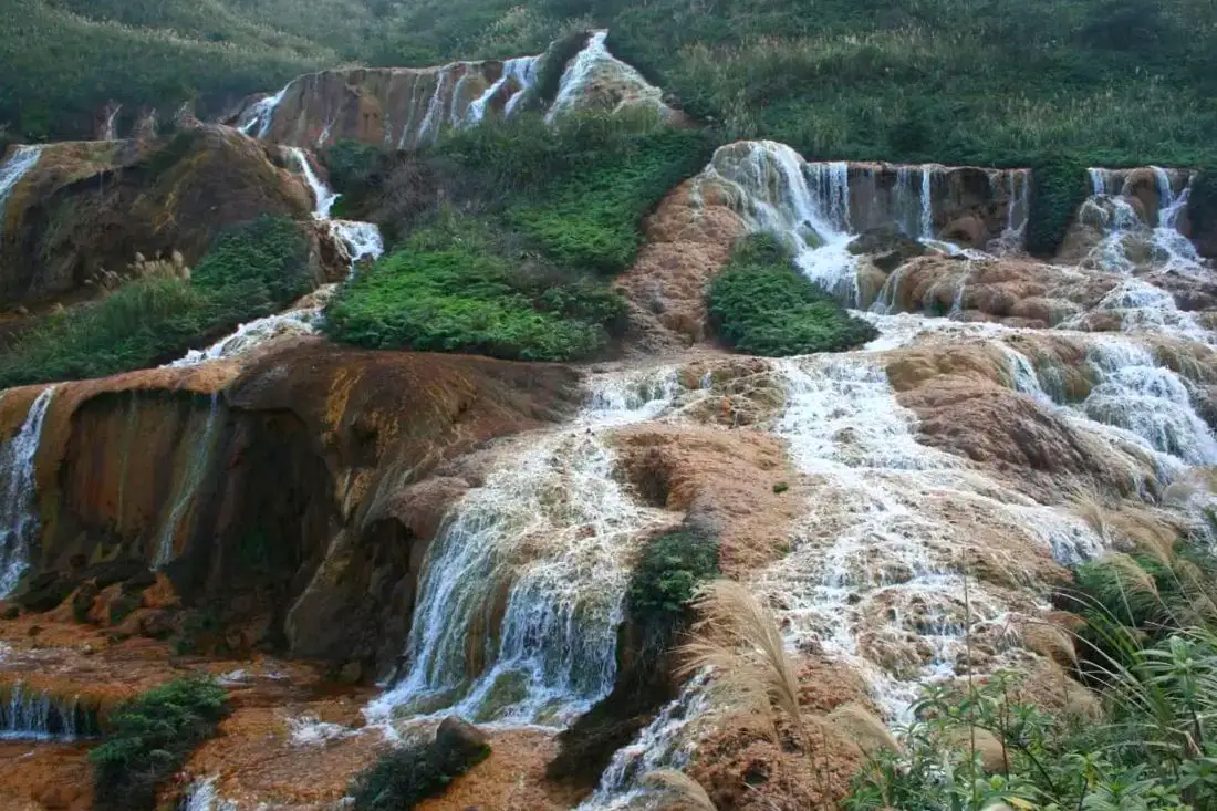
Another popular sight here is the golden waterfalls, which are colored gold because of the mine and mineral runoff collected as the water moves through old mines. Jinguashi is a small village in Ruifang District in New Taipei, famous for its now defunct mines. Here you can explore the Gold Mine Museum, touch a multi-million dollar gold ingot, see golden waterfalls, go on some of the best hikes in Taiwan, check out the old mining town, see Japanese era historic sites, and explore abandoned mining sites.
Historical Background: In 1890 during the Qing Dynasty, gold was found in the Keelung River during the construction of Taiwan's first railroad, which led to a small gold rush. Gold seams were eventually found in the mountains behind Jiufen around what is today Jinguashi. The name Jinguashui (金瓜石 Jīnguāshí), literally meaning "Gold Gourd Stone" comes from the shape of the nearby Keelung Mountain, which resembled a Pumpkin "Nánguā 南瓜" to early settlers, and the fact that early gold miners found lots of little gold seams resembling small gourds. After Taiwan was colonized by the Japanese in 1895, the Japanese quickly took control of the mines at Jinguashi, banning locals from owning mining rights. They quickly found many more copper and gold seams, and Jinguashi became the number one gold mine in the Japanese empire. During WWI, the mine came upon difficult times, and mining rights were passed to what is now Japan Energy, who built the 13 level complex that sits abandoned today. By 1938 it had become the most profitable gold mine in Asia, and population grew to over 80,000. During WWII, the mining operations switched from gold to copper, and the area was used as a POW camp. After the ROC took Taiwan, the mines were used mainly for copper, as the cost of refining gold was too high. The Chalet built for the crown prince of Japan at Jinguashi was later used by Chiang Kai-shek. After worldwide copper prices collapsed in the 1980s, the mine shut down for good in 1987. After that, people moved out of the town, and Jinguashi has a population of just about 2,000 people. Later mining initiatives have been met with strong criticism from environmentalists. In 2004, the New Taipei City Gold Mine Museum was completed, using several abandoned mining sites near Jinguashi, making it a popular tourist attraction in the area. Gold Mine Museum Hours: 9:30 AM to 5 PM, closed Mondays Gold Mine Museum Price: 80 NT per person (Free for New Taipei Residents) You can book discount tickets to the New Taipei Gold Mine Museum on Klook here or KKday here. Tours: You can book a tour to Golden Waterfall on TripAdvisor here, Klook here or KKday here. Hotels near Jinguashi: We recommend Fullon Hotel which has locations in Tamsui and Fulong near the beach (book on Booking.com here, Tripadvisor here, Agoda here, or Hotels.com here). We have stayed at and recommend Gold Mountain Ranch, which is a horse ranch and glamping destination in Jinshan. You can book a night at Gold Mountain Ranch on Klook here. You can also check out our full blog on the ranch here. We have also stayed at and recommend Hai Xia Your Home which is right in front of Fulong Beach (book on Booking.com here, Tripadvisor here, Agoda here, or Hotels.com here). Looking for a hotel? We recommend booking through Booking.com here, which provides the best quality selection of accommodation in Taiwan. Find out where to stay in our Taiwan hotels guide or search for the best hotel deals in Taiwan here. How to get There: By Train: Take TRA to Ruifang Station, then transfer to Keelung Bus which goes directly to Jinguashi every few minutes (about a 15 minute ride from Ruifang). Book tickets via the normal train (TRA) on Klook here. You can book tickets to the high speed rail (HSR) on Klook here or KKDay here. By Bus: Buses directly to Jinguashi leave from Taipei Main Station, Taipei City Hall, and Songshan Station regularly via Keelung Bus. You can also book a shuttle bus to Jiufen from Taipei on KKDay here. You can also book tickets to travel to Jiufen via inter-city bus on Klook here. By Car/Scooter: Take provincial highway 2 to Ruifang and then travel on highway 102 all the way up to Jiufen, then go over the mountain and keep going down to Jinguashi. Parking is scarce, and if you drive a car you need to park at the bottom of the hill and take the bus up to the gold mine museum. There is free scooter parking at the entrance. Looking for scooter rental in New Taipei? Click here or here to search for options. You can also check out our scooter rental guide here. If you are looking for car rentals, you can also search here. You can also check out our car rental guide here. By Taxi: You can take short rides for about 150 NT, or hire a Taxi for a day for around 150 USD. You can also charter a car for a day to Jinguashi on Klook here. By Bicycle: Cycling is the best way to enjoy Taiwan's landscapes if you have the time and energy. Looking for bicycle rentals in Taiwan? You can use Taiwan's many Youbike sharing stations, or search for rentals on KKday here, and search for tours on Klook here. You can also check out our Taiwan cycling guide here. You can also book a cycling tour on TripAdvisor here. For more information, check out our Taiwan transportation guide here. Map: Please see below: 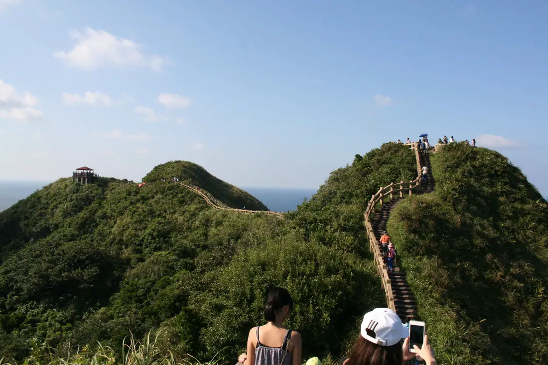
Bitou Cape (aka Bitoujiao/Bítóujiǎo) is a scenic area of coastline in Ruifang District of New Taipei, along the northeast coast, with popular hiking trails, interesting geological formations, a refurbished tourist military complex. and steep sea cliffs. It is a beautiful area along the coast that you should be sure to not miss.
Background: The sandstone that forms Bitou Cape was formed as sediment under the ocean millions of years ago and were then uplifted thanks to the collision of the Eurasian and Philippine plates. The rocks are mainly sedimentary and are part of the same formation that forms the special rock formations on the northern coast around Keelung. Because of this, there are many interesting eroded rock formations around the cape. The name Bitou (鼻頭) means the tip of the nose in Chinese. Bitoujiao Lighthouse was completed in 1897, built by the Japanese. Later it was repaired in WWII, and is still used today. The ROC army/navy military base at Bitou Cape has been sitting dormant for over 20 years, and was finally opened to the public as a rainbow "pink" military base to attract tourists on May 1st, 2020. The area is a popular weekend destination for many residents of Northern Taiwan. Hours: 24/7 Price: Free Tours: You can book a tour to Bitou Cape on KKday here or Klook here. Activities along Taiwan's Northern Coast: Don't forget that there are many activities available along Taiwan's Northern Coast such as Wakeboarding, Surfing, Speedboat Surfing, SUP / Paddle Boarding, Diving, Snorkeling Kayaking, Canoeing, Water Biking, River Tracing / Canyoneering, ATVing, Horse Riding, Archery, Tree Climbing, Glamping, Motorcycling, Motorbike Tour, Dragon Boat Racing, Shen'ao Rail Bike, and more on Tripadvisor here, Klook here, or KKday here. Hotels on Taiwan's Northern Coast: We recommend Fullon Hotel which has locations in Tamsui and Fulong near the beach (book on Booking.com here, Tripadvisor here, Agoda here, or Hotels.com here). We have stayed at and recommend Gold Mountain Ranch, which is a horse ranch and glamping destination in Jinshan. You can book a night at Gold Mountain Ranch on Klook here. You can also check out our full blog on the ranch here. We have also stayed at and recommend Hai Xia Your Home which is right in front of Fulong Beach (book on Booking.com here, Tripadvisor here, Agoda here, or Hotels.com here). Looking for a hotel? We recommend booking through Booking.com here, which provides the best quality selection of accommodation in Taiwan. Find out where to stay in our Taiwan hotels guide or search for the best hotel deals in Taiwan here. How to get there: By Car/Scooter: From Keelung, take provincial highway 2 east along the north coast until you reach the Bitou Fishing Harbor. There is limited parking near the harbor, and further free parking on the other side of the tunnel but it is a bit of a walk. If you are looking for car rentals, you can also search Qeeq here, Klook here, or KKday here. You can also check out our car rental guide here. Looking for scooter rental in northern Taiwan? You can search on Klook here or KKday here to search for options. You can also check out our scooter rental guide here. By Bus: From Keelung TRA Station, take Keelung Bus 791 east about two hours to Bitou cape. You can purchase a discount easy card to use on the MRT and buses from Klook here or KKday here. You can also book an MRT travel pass on Klook here. By Bicycle: Cycling is the best way to enjoy Taiwan's landscapes if you have the time and energy. Looking for bicycle rentals in Taiwan? You can use Taiwan's many Youbike sharing stations, or search for rentals on KKday here, and search for tours on Klook here. You can also check out our Taiwan cycling guide here. You can also book a cycling tour on TripAdvisor here. For more information, check out our Taiwan transportation guide here. Map: Please see below: 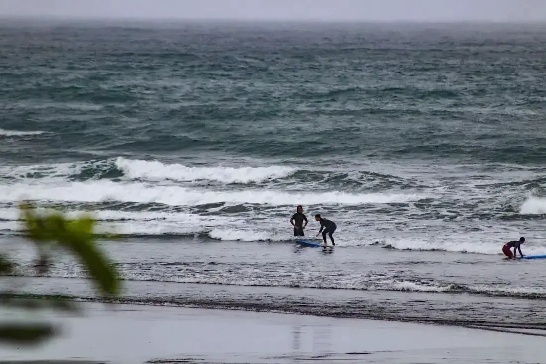
Double Lion Beach is a quiet surfing beach in Yilan County. There are fewer people here and awesome waves. The reason it is called Double Lion Beach is because of the two lions in front of the temple that looks over the beach. It is definitely worth a stop on your next trip to Yilan.
Background: Before Chinese settlers came, the area around Toucheng was inhabited by the Ketagalan Aboriginal tribe, whose language is now extinct. The name Toucheng literally means "first town" in Chinese, because it was the first settlement in Yilan, settled in the late 1700s. With the nearby Wushih and Touwei Harbors around the same time, it became the economic focal point of Yilan. However in the late 1800s and early 1900s Wushih Harbor and Touwei Harbor silted in, reducing their function. With the advent of the Japanese built Yilan railway line in the mid-1900's, as well as constant floods and continually silting of the harbors, Toucheng quickly lost its importance economically and fell into decay. After residents of Turtle Island were relocated to Daxi in Toucheng, Daxi Harbor was expanded and has become one of the largest fishing harbors in the area. Due to its close proximity to Taipei, Toucheng has become a major tourist area and may be the most popular surfing location in Taiwan. Tours and Activities: You can book a surfing lesson at Double Lion Beach on KKday here. Accommodation: We have stayed at and recommend Toucheng Leisure Farm. You can also book a room there on Klook here, Agoda here, Booking.com here, Hotels.com here, Expedia here, or Trip.com here. Looking for a hotel? We recommend booking through Agoda here, which provides the best quality selection of accommodation in Taiwan. Find out where to stay in our Taiwan hotels guide or search for the best hotel deals in Taiwan here. How to get there: By TRA: Take the TRA to any of the stations in Toucheng. You can book tickets to travel to Yilan via inter-city bus on Klook here. You can book tickets to Yialn via high speed rail (HSR) on Klook here or KKDay here. Book tickets via the normal train (TRA) on Klook here. Bicycle rental: Cycling is the best way to enjoy Taiwan's landscapes if you have the time and energy. Looking for bicycle rentals in Taiwan? You can search on KKday here and search for tours on Klook here. You can also check out our Taiwan cycling guide here. By Car: From Taipei, take National Freeway 5 to Toucheng. Be careful to note that on Sundays there are highway controls for cars travelling from Yilan to Taipei from 3 PM to 8 PM, so avoid travelling back to Taipei at that time to beat the traffic. Looking for scooter rental in Yilan? You can search Klook here or KKday here to look for options. You can also check out our scooter rental guide here. If you are looking for car rentals in Yilan, you can also search Klook here or KKDay here. You can also check out our car rental guide here. Map: Please see below: 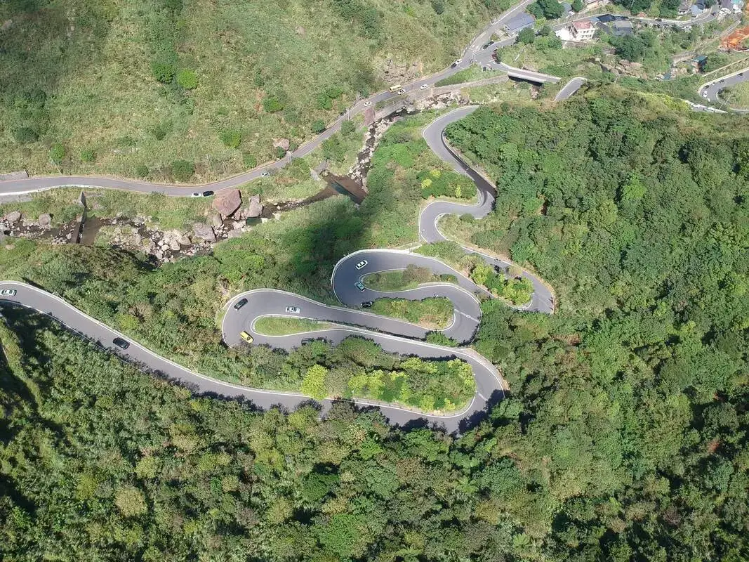
Jinshui Road winds up from the ocean up to Jinguashi. Even though it is one lane, buses still come up and down this thing constantly. From the mountains above you can enjoy views of this unique, steep, winding road in northern Taiwan.
Historical Background: In 1890 during the Qing Dynasty, gold was found in the Keelung River during the construction of Taiwan's first railroad, which led to a small gold rush. Gold seams were eventually found in the mountains behind Jiufen around what is today Jinguashi. The name Jinguashui (金瓜石 Jīnguāshí), literally meaning "Gold Gourd Stone" comes from the shape of the nearby Keelung Mountain, which resembled a Pumpkin "Nánguā 南瓜" to early settlers, and the fact that early gold miners found lots of little gold seams resembling small gourds. After Taiwan was colonized by the Japanese in 1895, the Japanese quickly took control of the mines at Jinguashi, banning locals from owning mining rights. They quickly found many more copper and gold seams, and Jinguashi became the number one gold mine in the Japanese empire. During WWI, the mine came upon difficult times, and mining rights were passed to what is now Japan Energy, who built the 13 level complex that sits abandoned today. By 1938 it had become the most profitable gold mine in Asia, and population grew to over 80,000. During WWII, the mining operations switched from gold to copper, and the area was used as a POW camp. After the ROC took Taiwan, the mines were used mainly for copper, as the cost of refining gold was too high. The Chalet built for the crown prince of Japan at Jinguashi was later used by Chiang Kai-shek. After worldwide copper prices collapsed in the 1980s, the mine shut down for good in 1987. After that, people moved out of the town, and Jinguashi has a population of just about 2,000 people. Later mining initiatives have been met with strong criticism from environmentalists. In 2004, the New Taipei City Gold Mine Museum was completed, using several abandoned mining sites near Jinguashi, making it a popular tourist attraction in the area. Gold Mine Museum Hours: 9:30 AM to 5 PM, closed Mondays Gold Mine Museum Price: 80 NT per person (Free for New Taipei Residents) You can book discount tickets to the New Taipei Gold Mine Museum on Klook here or KKday here. Tours: You can book a tour to Jinguashi on TripAdvisor here, Klook here or KKday here. Hotels near Jinguashi: We recommend Fullon Hotel which has locations in Tamsui and Fulong near the beach (book on Booking.com here, Tripadvisor here, Agoda here, or Hotels.com here). We have stayed at and recommend Gold Mountain Ranch, which is a horse ranch and glamping destination in Jinshan. You can book a night at Gold Mountain Ranch on Klook here. You can also check out our full blog on the ranch here. We have also stayed at and recommend Hai Xia Your Home which is right in front of Fulong Beach (book on Booking.com here, Tripadvisor here, Agoda here, or Hotels.com here). Looking for a hotel? We recommend booking through Booking.com here, which provides the best quality selection of accommodation in Taiwan. Find out where to stay in our Taiwan hotels guide or search for the best hotel deals in Taiwan here. How to get There: By Train: Take TRA to Ruifang Station, then transfer to Keelung Bus which goes directly to Jinguashi every few minutes (about a 15 minute ride from Ruifang). Book tickets via the normal train (TRA) on Klook here. You can book tickets to the high speed rail (HSR) on Klook here or KKDay here. By Bus: Buses directly to Jinguashi leave from Taipei Main Station, Taipei City Hall, and Songshan Station regularly via Keelung Bus. You can also book a shuttle bus to Jiufen from Taipei on KKDay here. You can also book tickets to travel to Jiufen via inter-city bus on Klook here. By Car/Scooter: Take provincial highway 2 to Ruifang and then travel on highway 102 all the way up to Jiufen, then go over the mountain and keep going down to Jinguashi. Parking is scarce, and if you drive a car you need to park at the bottom of the hill and take the bus up to the gold mine museum. There is free scooter parking at the entrance. Looking for scooter rental in New Taipei? Click here or here to search for options. You can also check out our scooter rental guide here. If you are looking for car rentals, you can also search here. You can also check out our car rental guide here. By Taxi: You can take short rides for about 150 NT, or hire a Taxi for a day for around 150 USD. You can also charter a car for a day to Jinguashi on Klook here. By Bicycle: Cycling is the best way to enjoy Taiwan's landscapes if you have the time and energy. Looking for bicycle rentals in Taiwan? You can use Taiwan's many Youbike sharing stations, or search for rentals on KKday here, and search for tours on Klook here. You can also check out our Taiwan cycling guide here. You can also book a cycling tour on TripAdvisor here. For more information, check out our Taiwan transportation guide here. Map: Please see below: Map: Please see below: 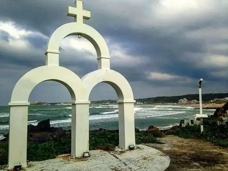
Linshanbi Cape is a rocky area on the south side of Baishawan Beach. Here you can find great views of the surrounding area, volcanic rock formations, as well as a variety of marine life. It is a great place to connect with nature along Taiwan's North Coast.
Background: "Linshanbi is a cape located next to Baishawan (White Sand Bay) to the west of Fuguei Cape, which is the northernmost point of Taiwan. It rises about 30 meters above the sea. Kike Fuguei Cape, Linshanbi has an abundance of andesite, evidence of volcanic eruption in the distant past. A circular rock formation at the northern edge of the cape looks natural but is actually a fish trap built by fishermen in early times. Fish and shrimp that enter the trap at high tide are captured in the trap when the tidal waters recede, leaving a wide variety of marine life for viewing fish, shrimp, crabs, snails, chitons, and anemones. This is a veritable classroom for teaching children to know sea life." Price: Free Parking: There is paid parking nearby. Hours: May, June, and October 9AM - 5PM July, August, and September 9AM - 6PM Tours: You can book a tour to Taiwan's North Coast on TripAdvisor here, Klook here, or KKday here. You can book a Private Laomei Green Reef Day Tour from Taipei on TripAdvisor here or KKday here. Activities: Don't forget that there are many activities available along Taiwan's Northern Coast such as Wakeboarding, Surfing, Speedboat Surfing, SUP / Paddle Boarding, Diving, Snorkeling Kayaking, Canoeing, Water Biking, River Tracing / Canyoneering, ATVing, Horse Riding, Archery, Tree Climbing, Glamping, Motorcycling, Motorbike Tour, Dragon Boat Racing, Shen'ao Rail Bike, and more on Tripadvisor here, Klook here, or KKday here. Hotels on Taiwan's Northern Coast: We recommend Fullon Hotel which has locations in Tamsui and Fulong near the beach (book on Booking.com here, Tripadvisor here, Agoda here, or Hotels.com here). We have also stayed at and recommend Hai Xia Your Home which is right in front of Fulong Beach (book on Booking.com here, Tripadvisor here, Agoda here, or Hotels.com here). Looking for a hotel? We recommend booking through Booking.com here, which provides the best quality selection of accommodation in Taiwan. Find out where to stay in our Taiwan hotels guide or search for the best hotel deals in Taiwan here. How to Get There: By Bus: Take Keelung bus from either Danshui MRT station or Keelung TRA station. You can also take the yellow and white North Coast Shuttle Bus to Baishawan station. You can purchase a discount easy card to use on the MRT and buses from Klook here or KKday here. You can also book an MRT travel pass on Klook here. By Car/Scooter: Drive on Provincial Highway 2 out of Danshui to the northeast, or out of Keelung to the northwest. The beach area is near Sanzhi District 三芝區. If you are looking for car rentals, you can also search Qeeq here, Klook here, or KKday here. You can also check out our car rental guide here. Looking for scooter rental in northern Taiwan? You can search on Klook here or KKday here to search for options. You can also check out our scooter rental guide here. By Bicycle: Cycling is the best way to enjoy Taiwan's landscapes if you have the time and energy. Looking for bicycle rentals in Taiwan? You can use Taiwan's many Youbike sharing stations, or search for rentals on KKday here, and search for tours on Klook here. You can also check out our Taiwan cycling guide here. You can also book a cycling tour on TripAdvisor here. For more information, check out our Taiwan transportation guide here. Map: 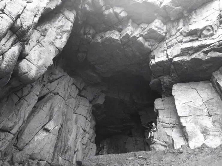
Longdong (aka Dragon Caves -龍洞 Lóngdòng) is a popular spot for snorkeling, scuba diving, and rock climbing. There is also a large sea cave there (pictured above) from where the place gets its name.
Background: The sandstone that forms Longdong was formed as sediment under the ocean millions of years ago and were then uplifted thanks to the collision of the Eurasian and Philippine plates. The rocks are mainly sedimentary and are part of the same formation that forms the special rock formations on the northern coast around Keelung. Because of this, there are many interesting eroded rock formations around the cape. The name Longdong (龍洞 Lóngdòng) means dragon cave in Chinese, named after the prominent cave in the area. The area is a popular weekend destination for many residents of Northern Taiwan. Hours: 24/7 Price: Free Tours and Activities: You can book activities at Longdong such as Rock Climbing, Cave Draping, Diving, Snorkeling, SUPing, Freediving, and more on Klook here or KKday here. How to get there: By Car/Scooter: From Keelung, take provincial highway 2 east along the north coast until you reach the Longdong. There is limited parking near the harbor, and further free parking farther away. If you are looking for car rentals, you can also search Qeeq here, Klook here, or KKday here. You can also check out our car rental guide here. Looking for scooter rental in northern Taiwan? You can search on Klook here or KKday here to search for options. You can also check out our scooter rental guide here. By Bus: From Keelung TRA Station, take Keelung Bus 791 east about two hours to Longdong. You can purchase a discount easy card to use on the MRT and buses from Klook here or KKday here. You can also book an MRT travel pass on Klook here. By Bicycle: Cycling is the best way to enjoy Taiwan's landscapes if you have the time and energy. Looking for bicycle rentals in Taiwan? You can use Taiwan's many Youbike sharing stations, or search for rentals on KKday here, and search for tours on Klook here. You can also check out our Taiwan cycling guide here. You can also book a cycling tour on TripAdvisor here. For more information, check out our Taiwan transportation guide here. Map: Please see below: |
Author 作家I am an American expat who has extensive experience living, working, and traveling in Taiwan. In my day, I had to learn many things about Taiwan the hard way. But I have come to learn that Taiwan is one of the best places in the world for Foreigners to live. This blog does not represent the opinions of every foreigner in Taiwan. I am just trying to help others learn more about this beautiful country. Categories
|
 RSS Feed
