

Shiding District is a secret mountain paradise in New Taipei City, in northern Taiwan (新北市石碇區). Lots of people simply pass through here without knowing much about what there is to see. In this guide I will show you some of the secret historical and nature destinations in this amazing place.
Historical Background: The name Shiding comes from boats transporting goods from the area that used to use large rocks (shi 石) in the river as anchors (ding 碇). The Shiding administrative area (石碇堡) was created during the Qing Dynasty and extended from Keelung to Wenshan District. The area around Shiding Old Street was the first area to be developed by Han Chinese in Shiding. In the early days during the Qing Dynasty, the Han Chinese settlers here mainly grew tea and leeks. During the Qing Dynasty, Shiding was an important stop along the Danlan Old Trail (淡蘭古道 which means the road between Tamsui and Yilan), which was split into three paths, and Shiding was on the Southern Path. The Southern Path winded from Mengjia Old Street to Liuzhangli, then to Shengkeng, and onto Shiding which was a major tea producer at the time. From Shiding, the road then went to Pinglin and then Yilan. The Southern path was the quickest way to Yilan. During the Japanese Era until the 1980s, the major industry in the area was coal mining, As the coal mining industry winded down in the 1980s and 90s in Taiwan due to lower worldwide coal prices, the economy in Shiding suffered and many people left. The multi story buildings near Shiding Old street are a testament to the economic prosperity of the coal mining era. Currently Shiding is sparsely populated with the main economic activity including tea farming and agriculture. Tours of Shiding: You can book a tour to Shiding on TripAdvisor here, Klook here, or KKday here. Hotels in Taipei: We have stayed at and recommend the Yuanshan Grand Hotel, once the tallest building in Taiwan and still the most grand (book on Booking.com here, Tripadvisor here, or Agoda here). We have stayed at and also recommend Fu Chang Hotel in Ximending, which is within walking distance of Ximending shopping district (book on Booking.com here, Tripadvisor here, or Agoda here). Looking for a hotel? We recommend booking through Booking.com here, which provides the best quality selection of accommodation in Taiwan. Find out where to stay in our Taiwan hotels guide or search for the best hotel deals in Taiwan here. How to get there: By Car: Go east on National Freeway 5, then get off at the Shiding interchange. Continue east until you reach Shiding Old Street. If you are looking for car rentals, you can also search Qeeq here, Klook here, or KKday here. You can also check out our car rental guide here. By Scooter: From Taipei, take highway 106 east from Shenkeng toward Shiding, pass through Shiding Bao Tunnel, and soon you will come to Shiding Old Street. Looking for scooter rental in Taipei? You can search on Klook here or KKday here to search for options. You can also check out our scooter rental guide here. By Bus: From Taipei City Call MRT station, you can take bus 912 to Shiding High School, after that you will have to switch to bus 666 which will take you all the way to the old street (total about 40 minutes). You can also book tickets to travel to Shiding via inter-city bus on Klook here. You can also book a Taipei Sightseeing: Hop On, Hop Off Open Top Bus on TripAdvisor here. By Bicycle: Cycling is the best way to enjoy Taiwan's landscapes if you have the time and energy. Looking for bicycle rentals in Taiwan? You can use Taiwan's many Youbike sharing stations, or search for rentals on KKday here, and search for tours on Klook here. You can also check out our Taiwan cycling guide here. You can also book a Sunset Riverside Bike Ride and Historical Tour, 4 Hour Cycling in Taipei, Ultimate 8-Hour Cycling City Tour, or Taipei City Bike Tour with Night Market Experience on TripAdvisor here. For more information, check out our Taiwan transportation guide here. Map:
0 Comments
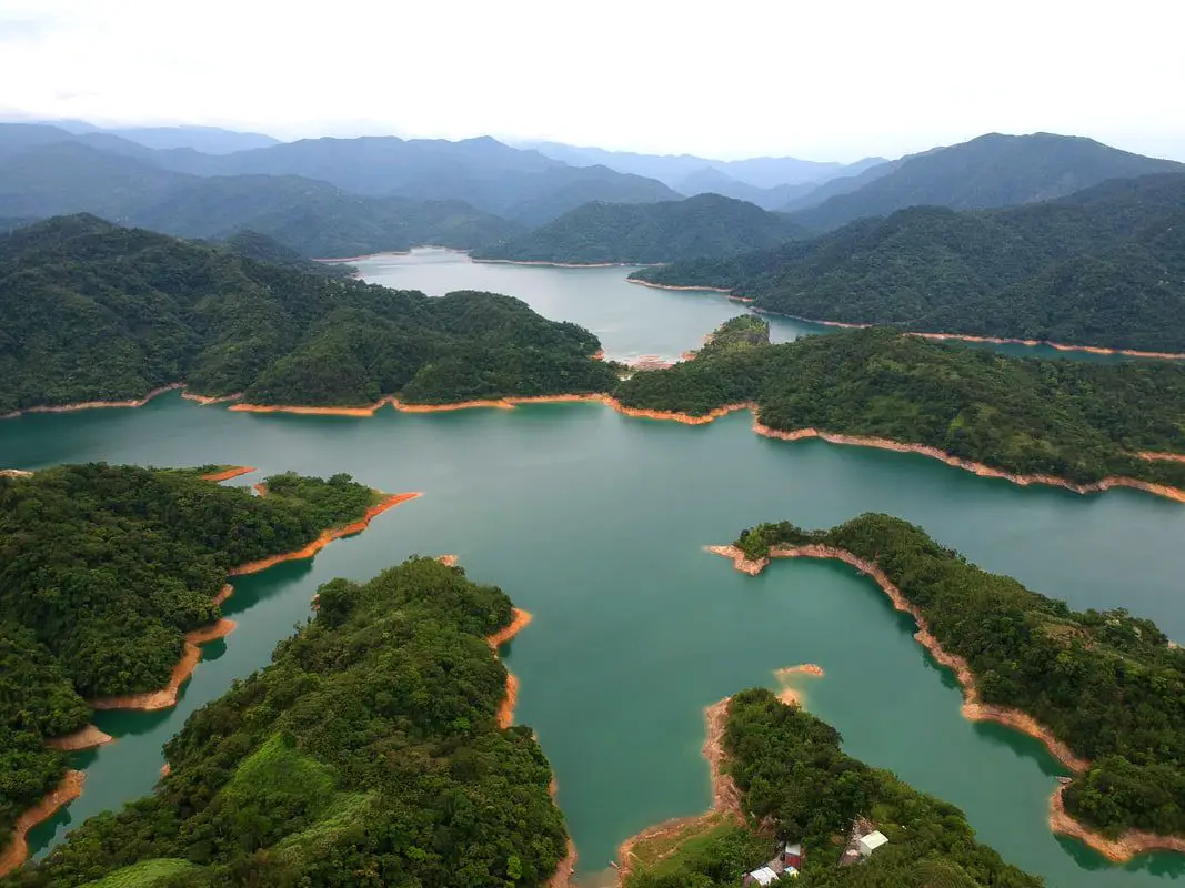
Thousand Island Lake (Officially Feitsui Reservoir 翡翠水庫 or Emerald Lake) is a reservoir in New Taipei that sits in Shiding District. It is a popular place to visit because the reservoir winding through the mountain valleys looks like many islands from a distance. It also has the largest concrete dam in Taiwan.
Background: When it was seen in the 1970s that the Shimen Dam could not meet all the water needs of greater Taipei, the Taipei City government set out to build another dam along the Beishi River. The Dam was completed in 1987 at a cost of 11 billion NT. The Dam holding the reservoir back is 122 meters high and 510 meters long, making it the biggest concrete dam in Taiwan by volume. The Dam today serves over 6 million people in greater Taipei. Besides providing water, the dam also generates electricity. To ensure water quality, most of the Dam is closed off the the public, expect with a permit and accompaniment by a guide. The best place to see the Dam is from the tea plantations on the Shiding side (northeast). Hours: 24/7 Price: Free Tours: You can book a tour to Thousand Island Lake on TripAdvisor here, Klook here or KKday here. Hotels in Taipei: We have stayed at and recommend the Yuanshan Grand Hotel, once the tallest building in Taiwan and still the most grand (book on Booking.com here, Tripadvisor here, or Agoda here). We have stayed at and also recommend Fu Chang Hotel in Ximending, which is within walking distance of Ximending shopping district (book on Booking.com here, Tripadvisor here, or Agoda here). Looking for a hotel? We recommend booking through Booking.com here, which provides the best quality selection of accommodation in Taiwan. Find out where to stay in our Taiwan hotels guide or search for the best hotel deals in Taiwan here. How to get there: Car/Scooter: Take provincial highway 9 east toward Pinglin. Take a right down the mountain right before Taipei Garden Cemetery. There are a few restaurants and lookouts along this road. Looking for scooter rental in Taipei? You can search on Klook here or KKday here to search for options. You can also check out our scooter rental guide here. If you are looking for car rentals, you can also search Qeeq here, Klook here, or KKday here. You can also check out our car rental guide here. Bus: Take Sindian Bus GR12 east to Shisangu Station. From there you can walk about half an hour down to the lookout. You can also book tickets to travel to Shiding via inter-city bus on Klook here. You can also book a Taipei Sightseeing: Hop On, Hop Off Open Top Bus on TripAdvisor here. By Bicycle: Cycling is the best way to enjoy Taiwan's landscapes if you have the time and energy. Looking for bicycle rentals in Taiwan? You can use Taiwan's many Youbike sharing stations, or search for rentals on KKday here, and search for tours on Klook here. You can also check out our Taiwan cycling guide here. You can also book a Sunset Riverside Bike Ride and Historical Tour, 4 Hour Cycling in Taipei, Ultimate 8-Hour Cycling City Tour, or Taipei City Bike Tour with Night Market Experience on TripAdvisor here. For more information, check out our Taiwan transportation guide here. Map: Please see below: 
Throughout the mountains of Shiding and Pingxi are quite a few sheer cliffs and rock walls, formed from sedimentary rock being thrust upward by tectonic forces. Many of these places are not well known and hard to get to, but they are beautiful features in Taiwan's mountainous terrain. One of the largest of such rock walls is the Yuguiling Rock Wall in Shiding, which is the largest sandstone cliff in Northern Taiwan.
Background: The rock formations that form the mountains of Shiding and Pingxi formed as sediment under the ocean millions of years ago and were then uplifted thanks to the collision of the Eurasian and Philippine plates. The rocks are mainly sedimentary and are part of the same formation that forms the special rock formations on the northern coast around Keelung. The rock wall here is on private property and so can only be enjoyed from the road. Holes in the rock wall also appear to be home to many birds. The cliff here is 100 meters high at the middle and nearly 300 meters wide, making it the highest sandstone cliff in northern Taiwan. Price: Free Hours: 24/7 Tours: You can book a tour to Shiding Old Street on TripAdvisor here, Klook here or KKday here. Hotels in Taipei: We have stayed at and recommend the Yuanshan Grand Hotel, once the tallest building in Taiwan and still the most grand (book on Booking.com here, Tripadvisor here, or Agoda here). We have stayed at and also recommend Fu Chang Hotel in Ximending, which is within walking distance of Ximending shopping district (book on Booking.com here, Tripadvisor here, or Agoda here). Looking for a hotel? We recommend booking through Booking.com here, which provides the best quality selection of accommodation in Taiwan. Find out where to stay in our Taiwan hotels guide or search for the best hotel deals in Taiwan here. How to get there: By Car/Scooter: Take highway 106 east through Shiding until you reach the large U shaped bridge before Yongding Village. Do not get on the bridge, and take a right under the bridge up the mountain valley. Keep going straight until you reach the rock walls. If you are looking for car rentals, you can also search Qeeq here, Klook here, or KKday here. You can also check out our car rental guide here. Looking for scooter rental in Taipei? You can search on Klook here or KKday here to search for options. You can also check out our scooter rental guide here. By Bus: Take bus 795 from Shiding until you reach Tengliaokeng (藤寮坑) station. From there it is about 4 KM or one hour walk to get to the cliffs, not ideal! You can also book tickets to travel to Shiding via inter-city bus on Klook here. You can also book a Taipei Sightseeing: Hop On, Hop Off Open Top Bus on TripAdvisor here. By Bicycle: Cycling is the best way to enjoy Taiwan's landscapes if you have the time and energy. Looking for bicycle rentals in Taiwan? You can use Taiwan's many Youbike sharing stations, or search for rentals on KKday here, and search for tours on Klook here. You can also check out our Taiwan cycling guide here. You can also book a Sunset Riverside Bike Ride and Historical Tour, 4 Hour Cycling in Taipei, Ultimate 8-Hour Cycling City Tour, or Taipei City Bike Tour with Night Market Experience on TripAdvisor here. For more information, check out our Taiwan transportation guide here. Map: Pleas see below: 
Ergeshan (aka Erge Mountain or Shijianshan) is a magnificent mountain hike in Shiding District of New Taipei. The trail features a short climb to a watch tower with 360 degrees of Xindian, Wenshan, and Shiding Districts. There are also great views of Taipei City and the surrounding area.
Background: The rock formations that form Ergeshan formed as sediment under the ocean millions of years ago, and was later uplifted thanks to the collision of the Eurasian and Phillipine plates. The rocks are mainly sedimentary and are part of the same formation that forms the special rock formations on the northern coast around Keelung, and the waterfalls in Pingxi. Ergeshan is the highest mountain in the surrounding area at 678 meters above sea level. It is one of the 100 lesser peaks in Taiwan. Hours: 24/7 Price: Free Length: 2.5 KM, 200 meters of elevation gain About 1.5 hours total Difficulty: Easy, The trail can be quite steep in some places, but overall an easy short hike. Tours: You can book a tour to Shiding on TripAdvisor here, Klook here or KKday here. Hotels in Taipei: We have stayed at and recommend the Yuanshan Grand Hotel, once the tallest building in Taiwan and still the most grand (book on Booking.com here, Tripadvisor here, or Agoda here). We have stayed at and also recommend Fu Chang Hotel in Ximending, which is within walking distance of Ximending shopping district (book on Booking.com here, Tripadvisor here, or Agoda here). Looking for a hotel? We recommend booking through Booking.com here, which provides the best quality selection of accommodation in Taiwan. Find out where to stay in our Taiwan hotels guide or search for the best hotel deals in Taiwan here. How to get there: By Bus: Take Bus GR12 from Xindian to Xiangdi Temple. The trailhead is about a 12 minute walk from there. You can also book tickets to travel to Shiding via inter-city bus on Klook here. You can also book a Taipei Sightseeing: Hop On, Hop Off Open Top Bus on TripAdvisor here. By Car/Scooter: Take provincial highway 9 to Xiandi Temple and take a turn up the mountain, and take a left at the monastery. The road ends at the trailhead. You can park further up the road for the faster way to get there. Looking for scooter rental in Taipei? You can search on Klook here or KKday here to search for options. You can also check out our scooter rental guide here. If you are looking for car rentals, you can also search Qeeq here, Klook here, or KKday here. You can also check out our car rental guide here. By Bicycle: Cycling is the best way to enjoy Taiwan's landscapes if you have the time and energy. Looking for bicycle rentals in Taiwan? You can use Taiwan's many Youbike sharing stations, or search for rentals on KKday here, and search for tours on Klook here. You can also check out our Taiwan cycling guide here. You can also book a Sunset Riverside Bike Ride and Historical Tour, 4 Hour Cycling in Taipei, Ultimate 8-Hour Cycling City Tour, or Taipei City Bike Tour with Night Market Experience on TripAdvisor here. For more information, check out our Taiwan transportation guide here. Map: Please see below: 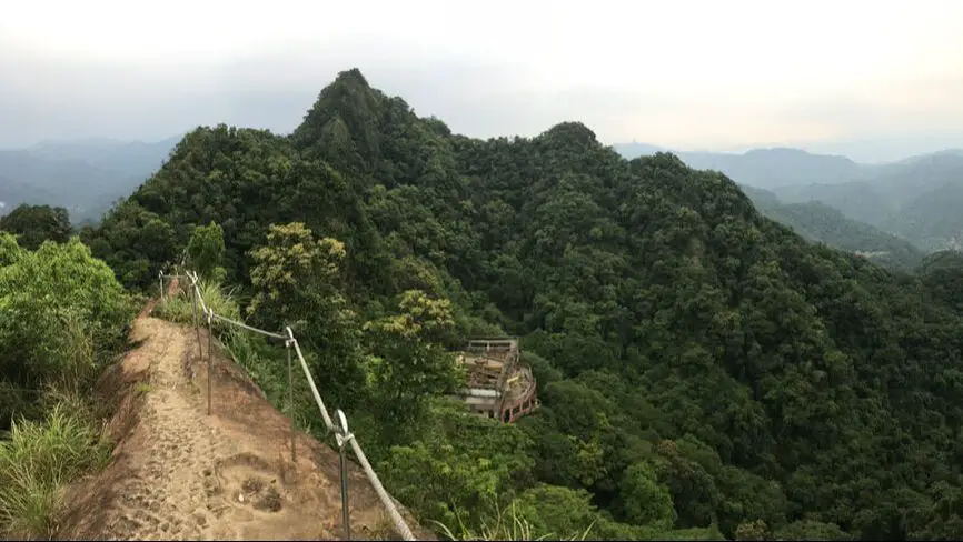
The Huangdidian Trail (aka Huangdi Temple Trail) is a magnificent mountain hike in Shiding District of New Taipei. The trail features ladder climbs, rope climbs, and rock climbs with the aid of ropes, and the top has a vertical drop on either side. There are also great views of Taipei and the surrounding area.
Background: The rock formations that form the Huangdidian hike formed as sediment under the ocean millions of years ago, and was later uplifted thanks to the collision of the Eurasian and Phillipine plates. The rocks are mainly sedimentary and are part of the same formation that forms the special rock formations on the northern coast around Keelung, and the waterfalls in Pingxi. Huangdidian gets its name from the Tianwang Temple below (天王廟) which is also known as the Huangdi Temple (皇帝殿). The Huangdidian trail climbs up Huangdidian Mountain, which has three peaks, the highest of which is 593 meters above sea level. Recently rope railings were installed at the top of the mountain to improve safety. Even so, the hike is still really scary. Hours: 24/7 Price: Free Length: 4.5 KM, 300 meters of elevation gain About three hours total Difficulty: Moderate, there are some rope climbs and ladder climbs up sheer rock face, and sheer drop-off on either side with little protection from falls in some places. Also the trail can be quite steep in some places. Tours: You can book a tour to Shiding on TripAdvisor here, Klook here or KKday here. Hotels in Taipei: We have stayed at and recommend the Yuanshan Grand Hotel, once the tallest building in Taiwan and still the most grand (book on Booking.com here, Tripadvisor here, or Agoda here). We have stayed at and also recommend Fu Chang Hotel in Ximending, which is within walking distance of Ximending shopping district (book on Booking.com here, Tripadvisor here, or Agoda here). Looking for a hotel? We recommend booking through Booking.com here, which provides the best quality selection of accommodation in Taiwan. Find out where to stay in our Taiwan hotels guide or search for the best hotel deals in Taiwan here. How to get there: By Bus: Take Bus 912 from Taipei City Hall, then switch buses at Wanfu Bridge. Take Bus 666 to Huangdi Temple station, and the trail head is about a 15 minute walk up the hill. You can also book tickets to travel to Shiding via inter-city bus on Klook here. You can also book a Taipei Sightseeing: Hop On, Hop Off Open Top Bus on TripAdvisor here. By Car/Scooter: Take highway 106 past Shiding Old Street, then turn left on a small road Marked "Huangdidian." There is a temple with a bunch of yellow lanterns in front of it. Looking for scooter rental in Taipei? You can search on Klook here or KKday here to search for options. You can also check out our scooter rental guide here. If you are looking for car rentals, you can also search Qeeq here, Klook here, or KKday here. You can also check out our car rental guide here. By Bicycle: Cycling is the best way to enjoy Taiwan's landscapes if you have the time and energy. Looking for bicycle rentals in Taiwan? You can use Taiwan's many Youbike sharing stations, or search for rentals on KKday here, and search for tours on Klook here. You can also check out our Taiwan cycling guide here. You can also book a Sunset Riverside Bike Ride and Historical Tour, 4 Hour Cycling in Taipei, Ultimate 8-Hour Cycling City Tour, or Taipei City Bike Tour with Night Market Experience on TripAdvisor here. For more information, check out our Taiwan transportation guide here. Map: Please see below: 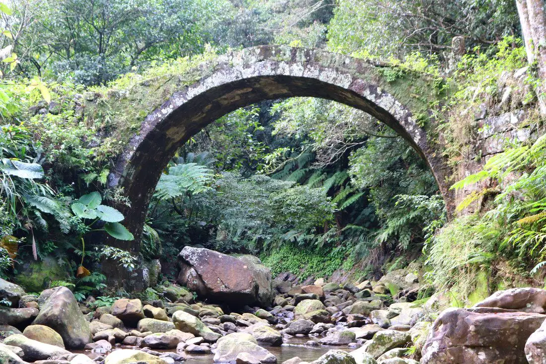
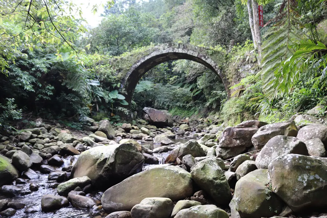
Pudu Changsheng Bridge is known as the most beautiful bridge in northern Taiwan. It is an old stone bridge that was built in 1953 to connect two small villages in the mountains of Shiding District. Now it is a popular spot for hikers and photographers.
Background: Puduchangsheng Bridge was finished in July 1953, to connect two mountain villages: Yuguiling Village (玉桂嶺村) and Fengtou Village (峰頭聚落) in Shiding. People had been living in these mountain villages since1887 during the Qing Dynasty. The trail between the two villages is about 650 meters long. The cost of the bridge construction was donated by the local villagers. Even though Yuguiling Road has now been built to connect the villages, the bridge still stands as a beautiful monument to the past. Hours: 24/7 Price: Free Tours: You can book a tour to Shiding on TripAdvisor here, Klook here or KKday here. Hotels in Taipei: We have stayed at and recommend the Yuanshan Grand Hotel, once the tallest building in Taiwan and still the most grand (book on Booking.com here, Tripadvisor here, or Agoda here). We have stayed at and also recommend Fu Chang Hotel in Ximending, which is within walking distance of Ximending shopping district (book on Booking.com here, Tripadvisor here, or Agoda here). Looking for a hotel? We recommend booking through Booking.com here, which provides the best quality selection of accommodation in Taiwan. Find out where to stay in our Taiwan hotels guide or search for the best hotel deals in Taiwan here. How to get there: By Car Scooter: Take highway 106 east through Shiding until you reach the large U shaped bridge before Yongding Village. Do not get on the bridge, and take a right under the bridge up the mountain valley. Keep going straight until you reach Yuguiling Road, and turn left. Keep going until you see the bridge on your right side after about 500 meters. Looking for scooter rental in Taipei? You can search on Klook here or KKday here to search for options. You can also check out our scooter rental guide here. If you are looking for car rentals, you can also search Qeeq here, Klook here, or KKday here. You can also check out our car rental guide here. By Bus: Take bus 795 from Shiding until you reach Tengliaokeng 藤寮坑 station. From there it is about 4 KM or one hour to get to the bridge, not ideal. You can also book tickets to travel to Shiding via inter-city bus on Klook here. You can also book a Taipei Sightseeing: Hop On, Hop Off Open Top Bus on TripAdvisor here. By Bicycle: Cycling is the best way to enjoy Taiwan's landscapes if you have the time and energy. Looking for bicycle rentals in Taiwan? You can use Taiwan's many Youbike sharing stations, or search for rentals on KKday here, and search for tours on Klook here. You can also check out our Taiwan cycling guide here. You can also book a Sunset Riverside Bike Ride and Historical Tour, 4 Hour Cycling in Taipei, Ultimate 8-Hour Cycling City Tour, or Taipei City Bike Tour with Night Market Experience on TripAdvisor here. For more information, check out our Taiwan transportation guide here. Map: Please see below: |
Author 作家I am an American expat who has extensive experience living, working, and traveling in Taiwan. In my day, I had to learn many things about Taiwan the hard way. But I have come to learn that Taiwan is one of the best places in the world for Foreigners to live. This blog does not represent the opinions of every foreigner in Taiwan. I am just trying to help others learn more about this beautiful country. Categories
|
 RSS Feed
