

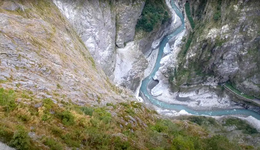
If you only have a few days in Taiwan and you want to go somewhere outside of Taipei, you should definitely go to Taroko National Park. On an island full of mountains, rain forests, beaches, and abounding natural beauty, Taroko might just take the top spot as the most beautiful scenic area in Taiwan.
Taroko National Park is well known for its amazing marble cliffs and canyons carved out by the Liwu River. It is also a popular spot for hiking, rafting, and river tracing. If you have the time, come to the East coast and see it. If you don't have time, then make some time! History and Background: Taroko National Park is well known for its marble cliffs and canyons, and is also known as "The Marble Gorge." Millions of years ago, the rock we see today was sediment at the bottom of the Pacific Ocean, but oceanic and tectonic pressure turned it into limestone, and later into marble. Later the Eurasian plate was uplifted where Taiwan is today, and a gorge was cut out of the limestone thanks to the Liwu River. Taroko means "human being," from the Truku tribal language. Originally the Tupido Tribe settled in the area of what is now Tianxiang Taiti mesa. They built the Tupido Tribe Trail which was only 30 cm wide, and resided there until they were massacred by the Japanese in 1914. In 1917, the Japanese expanded the original trail made by the Tupido Tribe to 1.5 M and forced aboriginal tribesmen to carry goods along the trail to the east coast. This is now the Zhuilu Old Trail. Currently only 3km of the trail is open to the public. The Japanese created a national park in the Area in 1937, which was disestablished by the ROC in 1945, and then reenstated in as a national park in 1986. When to visit? Hualien is great year round, but it can get a little hot in the summer, and Typhoon season and heavy rain season lasts from about May to October. If you are afraid of the heat and rain then you can visit during winter when the temperatures are mild and the climate is usually dryer. Sponsored Links Where to stay? Most of the accommodation you will find is near the city center. If you only want to visit Hualien City and Taroko Gorge, you can consider booking a hotel near downtown, walking or cycling around the city, and taking a bus to Taroko Gorge. We have stayed at and recommend Dream Taiwan Homestay (Agoda / Booking.com / Expedia / Hotels.com), a high quality hostel for the money in downtown Hualien, Farglory Hotel (Agoda / Booking.com / Expedia / Hotels.com), right next to Farglory Ocean Park with amazing views of Hualien, and Goldenflower B&B (Agoda / Booking.com) in Yuli right next to Sixty Stone Mountain. You can find out where to stay in our Taiwan hotels guide or search for the best hotel deals in Taiwan here. How to get there: By Car: From Taipei, Take National Highway 5 to Yilan and then drive on the Suhua Highway 9 to Hualien. A few miles before Hualien City, the gorge will be on your right. By Train: Take the train to Hualien station, and from there you can rent a scooter or car, or take a tour bus to the gorge. For more travel information see here. You can book tickets to travel to Hualien via inter-city bus on Klook here. Book tickets via the normal train (TRA) on Klook here. Need travel insurance? Compare prices on Insubuy here. How to get around in Taroko Gorge: As always, we recommend renting a scooter as the best way to see Taiwan. However, you can also a great deal of Tainan by taking the train, inter-city bus, local bus, biking, or just walking. Getting around in a car is also a convenient option as there is plenty of parking pretty much everywhere in this less crowded county. By Bus: You can book a shuttle bus to Taroko Gorge from Hualien on Klook here. Scooter Rental: Looking for scooter rental in Hualien? You can search KKday here or Klook here to look for options. You can also check out our scooter rental guide here. Car Rental: If you are looking for car rentals in Hualien, you can also search Klook here or KKDay here. You can also check out our car rental guide here. Tours: You can find more tours and activities in Hualien such as Surfing, Paragliding, SUP / Paddle Boarding, Kayaking, Canoeing, River Tracing, River Rafting, Whale Watching, Snorkeling, Diving, ATV / 4-wheeling, Paintballing, Farm Dream Estates Zoo, Water Biking, Oyster Harvesting, Shrimp Harvesting, Indigenous Experience, Glamping, Cycling, Ziplining and much more on Klook here or KKday here. You can also book Wifi and SIM cards for Taiwan on Gigago here. Just to let you know, if you book using the links above, we get some commission at no cost to you, and you can help support our blog. You can click here to receive $5 USD on your first Klook purchase. Hours: 8:30AM-5PM (Zhuilu old trail is open from 7AM to 10PM). Flying a Drone? Apply for a drone permit here. Price: Free! (Except Zhuilu old trail, which is 200 NT per adult. See below for more info.) Map: Please see below:
0 Comments
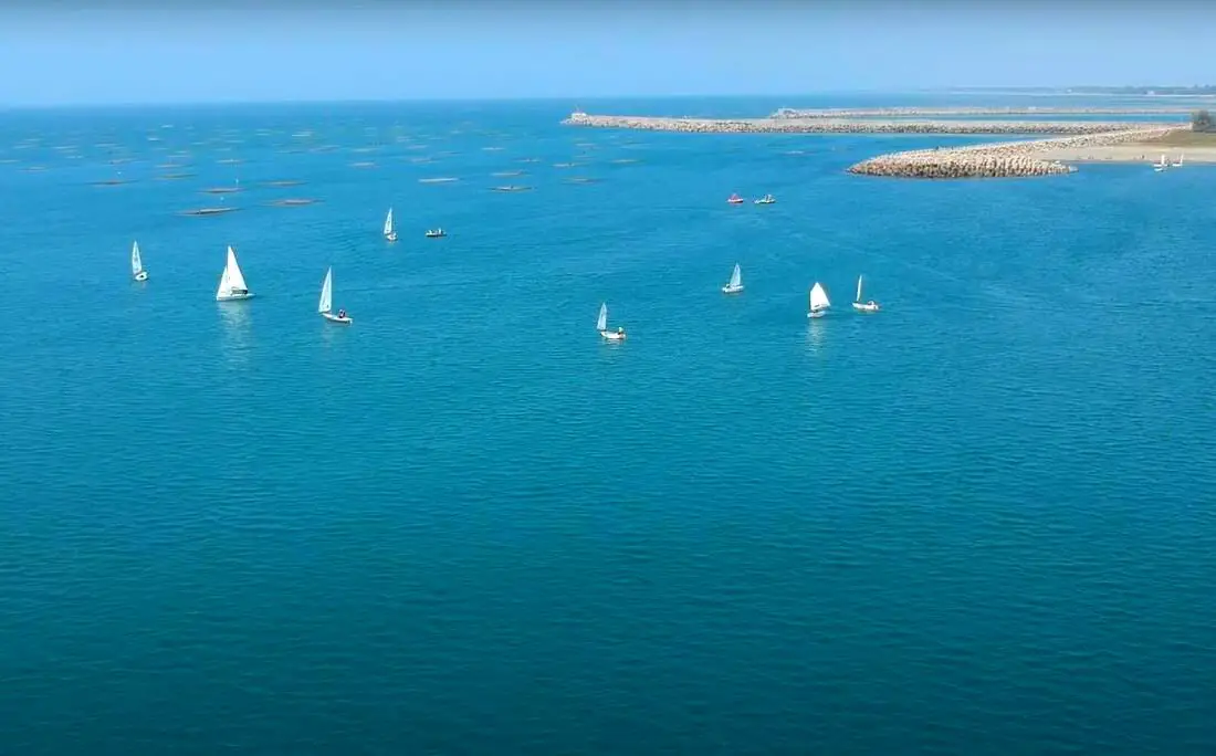
A sailing class going on off Tainan's Yuguang Island.
With over 100 islands and a coastline of over 1500 KM on the main Island, warm tropical weather, and constant winds, Taiwan is known as a world-class sailing location. Sailing in Taiwan can be an exhilarating experience that provides a unique perspective on the island’s stunning coastline and surrounding waters. With its rich history and culture, Taiwan has become a popular destination for adventure seekers and travelers looking to explore its natural beauty via sailboat.
Brief Historical Background of Sailing in Taiwan: Even though Taiwan has thousands of islands and hundreds of kilometers of coastline, it still does not have a strong sailing culture as compared to other countries. The recreational boating industry in Taiwan only really began in 2009, when the Fisheries Agency began making floating docks for more recreational craft. Those docks are now filled to capacity, so prices are on the rise and demand is high. Boat owners are hopeful that Taiwan's authorities can further expand recreational marinas in Taiwan soon. Non-powered sailing in Taiwan is regulated by the coast guard, but all you have to do is send your itinerary to the coast guard via a smartphone app. Where to Sail in Taiwan: 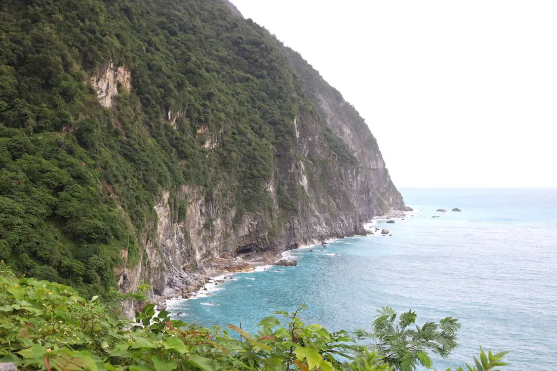
Taiwan's East Coast has the most beautiful scenery in Taiwan. From the deepest marble gorge in the world to outer islands, mountains, rivers, and huge sea cliffs, there are unmissable natural wonders for you to explore. In addition, there are endless outdoor activities and water sports that you can take part in here.
When to go: The best time to go they say is around May when it is not too hot and there are no northeasterly winds or typhoons. The typhoon season lasts from around June to October. The busy season is during summer break from June to August, during which time it can be hard to book a hostel or airplane ticket. Winter is the less crowded season, but the water will be colder, there will be constant wind (which could cancel transportation), and it will rain more often. How to get there: By Plane: Traveling to Taitung or Hualien by plane is the fastest way to get there. The trip only takes one hour from Taipei, and there are planes that leave daily through Mandarin Airlines and Uni Air. From Taitung, where you can switch to Saily Air which will take you the rest of the way to Green Island or Orchid Island. A plane ticket to Taitung takes about one hour and costs about 5000 NT per round trip. You can book discount tickets to Taitung on KKday here. By Train: The train ride from Taipei to Taitung takes 3-4 hours and costs about 800 NT one way. Book tickets via the normal train (TRA) on Klook here. By Bus: Busses leave hourly from Taipei to the East Coast. A bus from Taipei to Hualien now only takes about 2.5 hours. You can book tickets to travel to Taiwan's East Coast via inter-city bus on Klook here. By Bicycle: Cycling is the best way to enjoy Taiwan's landscapes if you have the time and energy. Looking for bicycle rentals in Taiwan? You can search on KKday here and search for tours on Klook here. You can also check out our Taiwan cycling guide here. By Car/Scooter: From Taipei, a car ride to Taitung takes about six hours, and a scooter ride takes about eight hours. You can rent a scooter on Klook or KKday. Scooter rental is about 300 NT per day. You can check out our scooter rental guide here. You can also rent a car for about 1500 NT per day. You can rent a car on Qeeq here or Klook here. You can hire a driver or taxi, and you can charter a car here. You can check out our car rental guide here. Tours: There are many tours and activities available on Taiwan's East Coast such as snorkeling, diving, SUPing, Surfing, Speed Boating, Glamping, River tracing, Paragliding, Kayaking, Canoeing, River Tracing, River Rafting, River Tubing, Pack Rafting, Whale Watching, ATV / 4-wheeling, Paintballing, Water Biking, Glamping, Cycling, Ziplining, Horse Riding, and many others, which you canbook through Klook here or KKday here. Accommodation: Looking for a hotel? We recommend booking through Agoda here, which provides the best quality selection of accommodation on the islands. Yilan: We have stayed at and recommend Ying Shih Guest House, a resort in Datong Township near Taipingshan and Fan Fan Hot Spring, and Jiaosi Hotspring Hotel, a hotel with hot springs in each room. We have also stayed at Toucheng Leisure Farm, a recreational farm and experience center in Toucheng (you can book on Agoda here). Hualien: We also have stayed at and recommend Dream Taiwan Homestay (Agoda / Booking.com), a high quality hostel for the money in downtown Hualien, Farglory Hotel (Agoda / Booking.com), right next to Farglory Ocean Park with amazing views of Hualien, and Goldenflower B&B (Agoda / Booking.com) in Yuli right next to Sixty Stone Mountain. You can find out where to stay in our Taiwan hotels guide or search for the best hotel deals in Taiwan here. Taitung: We have stayed at and recommend the Papago International Resort in Chishang, which is a five star hotel with private villas with pools for each room, and Mountain and Ocean B & B in Taimali, which is a quiet and affordable B&B right next to the beach. Looking for scooter rental in Taiwan? Click here or here to search for options. If you are looking for car rentals, you can also search here. You can also book Wifi and SIM cards for Taiwan on Gigago here. Just to let you know, if you book using the links above, we get some commission at no cost to you, and you can help support our blog. You can click here to receive $5 USD on your first Klook purchase. 
Riding a bicycle around Taiwan may be the best way to enjoy the island. Taiwan is known as the bicycle kingdom not just because it is one of the top manufacturers of bicycles in the world, but also because the Island of Taiwan has many amazing world-class roads waiting for cyclists to discover such as hundreds of kilometers of coastline, mountains above 3000 meters, and the world's deepest marble gorge. If you are a fan of cycling, you definitely need to check out this amazing island.
Looking for bicycle rentals in Taiwan? You can search on KKday here. Looking for a bike tour of Taiwn? Search KKday here to search for options. 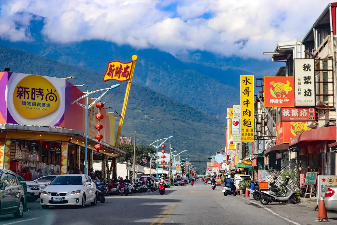
Hualien is the largest county in Taiwan and is considered by many to be the most beautiful. It includes a breathtaking coastline along the Pacific Ocean, including cliffs thousands of meters high, marble gorges, fertile valleys, and a large section of Taiwan's central mountain range. Hualien is simply a must-stop location on your trip to Taiwan.
Historical Background Hualien was first inhabited by Sakiraya aborigines and was known as Kilai. Later the Spanish came here to pan for gold for a brief period. Afterward, the first Han Chinese settlers came to the area in 1851 and named the place Hualien after the swirling delta of the Liwu River. During the Japanese era, many Japanese people were relocated here to develop agriculture. Now Hualien is the key population center on Taiwan's East Coast. When to visit? Hualien is great year round, but it can get a little hot in the summer, and Typhoon season and heavy rain season last from about May to October. If you are afraid of the heat and rain then you can visit during winter when the temperatures are mild and the climate is usually dryer. Where to stay? The best hostel I’ve ever stayed at is “When Happiness Knock Your Door” “幸福來敲門” in Hualien. The hostess will go out of her way to make you comfortable and her rooms are kept extremely nice. Also it was one of the few hostels I’ve ever been to that has an elevator. Her price is well below the quality you will enjoy. She has almost a perfect rating on Booking.com and Agoda. You can book When Happiness Knock Your Door on Agoda here, Booking.com here, Hotels.com here, Expedia here, Kayak here, TripAdvisor here, or Klook here. We have also stayed at and recommend Dream Taiwan Homestay (Agoda / Booking.com / Expedia / Hotels.com), a high quality hostel for the money in downtown Hualien, Farglory Hotel (Agoda / Booking.com / Expedia / Hotels.com), right next to Farglory Ocean Park with amazing views of Hualien, and Goldenflower B&B (Agoda / Booking.com) in Yuli right next to Sixty Stone Mountain. You can find out where to stay in our Taiwan hotels guide or search for the best hotel deals in Taiwan here. How to get to Hualien? You can book tickets to travel to Hualien via inter-city bus on Klook here. Book tickets via the normal train (TRA) on Klook here. Need travel insurance? Compare prices on Insubuy here. How to get around in Hualien: As always, we recommend renting a scooter as the best way to see Taiwan. However, you can also a great deal of Tainan by taking the train, inter-city bus, local bus, biking, or just walking. Getting around in a car is also a convenient option as there is plenty of parking pretty much everywhere in this less crowded county. Scooter Rental: Looking for a scooter rental in Hualien? You can search KKday here or Klook here to look for options. You can also check out our scooter rental guide here. Car Rental: If you are looking for car rentals in Hualien, you can also search Klook here or KKDay here. You can also check out our car rental guide here. By Bicycle: Cycling is the best way to enjoy Taiwan's landscapes if you have the time and energy. Looking for bicycle rentals in Taiwan? You can search on KKday here and search for tours on Klook here. You can also check out our Taiwan cycling guide here. Tours: You can find more tours and activities in Hualien such as Surfing, Paragliding, SUP / Paddle Boarding, Kayaking, Canoeing, River Tracing, River Rafting, Whale Watching, Snorkeling, Diving, ATV / 4-wheeling, Paintballing, Farm Dream Estates Zoo, Water Biking, Oyster Harvesting, Shrimp Harvesting, Indigenous Experience, Glamping, Cycling, Ziplining and much more on Klook here or KKday here. You can also book Wifi and SIM cards for Taiwan on Gigago here. Just to let you know, if you book using the links above, we get some commission at no cost to you, and you can help support our blog. You can click here to receive $5 USD on your first Klook purchase. Map: Please see the map below for the areas we will cover in the blog. 
Floral Seas in Taiwan (aka sea of flowers; flower sea; flower/floral ocean) are a popular attraction for locals all around the island. Many farmers actually harvest these flowers during winter months and allow tourists to come take photos with a backdrop of and ocean of flowers, usually for free. If you'd like to take a few photos of these places, there are quite a few options.
Where? You can find fields of flowers all over rural Taiwan during winter. For the more touristy places, you can to search 花海 into Google Maps and a bunch of places should pop up. Floral Seas that I have visited include Guanshan Floral Sea, Liugui Floral Sea, Zhuzihu, and Xinshe Sea of Flowers. Another one is 60 Stone Mountain (see our full blog on 60 Stone Mountain here). Looking for a hotel? Find out where to stay in our Taiwan hotels guide or search for the best hotel deals in Taiwan here. Looking for a hotel? We recommend booking through Agoda here, which provides the best quality selection of accommodation on the islands. You can find more tours of Taitung on Klook here or KKday here. When are floral seas open? Xinshe: November-December Guanshan: December-February Liugui Flower Sea: December-February 60 Stone Mountain: July-September Zhuzihu (Yangmingshan): Late February to early June Others: go find them! Floral seas can be found literally all over Taiwan. Maps: please see below: Guanshan Floral Sea: 
Taiwan's International Hot Air Balloon Festival, held every year in Taitung County during the summer, is one of the premiere tourism events in the country. Prepare to be amazed by an array of balloons, or enjoy the amazing natural scenery in Taitung by taking a tethered or non-tethered hot air balloon ride.
Background: Taiwan's hot air balloon festival started in 2011 in Luye Township of Taitung County, as a way for Taitung County to promote hot air balloon tourism. In 2013 the event changed its name to the Taiwan International Hot Air Balloon Festival and began to invite hot air balloons from other countries. Price: Tethered balloon ride (熱氣球繫留體驗): 550 NT to 650 NT Non-tethered balloon ride (熱氣球空中自由飛行): about 10,000 NT Paragliding (滑翔傘): 1800-2500 NT Hours/When to go: Tethered Balloon Ride (熱氣球繫留體驗): 4PM- 6:30PM or 4:30AM to 6:30AM (July to August). The ride lasts about 5 minutes. Ticketing website: KKday or EZtravel Untethered balloon ride (熱氣球空中自由飛行): Usually between 4AM and 6AM Ticketing website: Klook Warning: Hot Air Balloons can be cancelled with short notice due to bad weather such as too much wind, rain, or influence of a Typhoon. Live Feed: Check out a live feed of the Luye highland here: https://tour.taitung.gov.tw/en/media/live-camera/livecamera
Website:
https://balloontaiwan.taitung.gov.tw/en How to get there: By Train/Bus: From Taitung TRA station, there is a shuttle bus that leaves to Luye Highland at 4:10AM, 4:30AM, and 4:50AM, as well as 3PM, 3:30PM, and 4PM (75-120 NT per ride). Or, take the TRA to Luye station, and then walk, take a taxi, or take a bus to Luye Highlands (the train station is roughly 2 kilometers away from the highlands). By Car/scooter: From Taipei, take National Highway 5 to Yilan, then drive south on provincial road 9 until you get to Luye. See the map below for the location of the Highlands. It will be hard to miss. You can rent a scooter from Taitung Station on Klook or KKday. Scooter rental is about 300 NT per day.You can check out our scooter rental guide here. You can also rent a car for about 1500 NT per day. You can rent a car on Klook here. You can hire a driver or tax; you can charter a car here. By Plane: Fly into Taitung Airport from Taipei, then take a taxi/bus to the highlands. Where to stay: Booking accommodation in the Taitung can be difficult in the summer months and on weekends when rooms can be fully booked for months in advance. We suggest a better quality selection on Agoda.com. We have stayed at and recommend the Papago International Resort in Chishang (you can book on Agoda here or Booking.com here), which is a five star hotel with private villas with pools for each room, and Mountain and Ocean B & B in Taimali (you can book on Agoda here or Booking.com here), which is a quiet and affordable B&B right next to the beach. Tours: There are many companies offering snorkeling, diving, SUPing, Surfing, Speed Boating, Glamping, River tracing and other tours in Taitung. You can find more tours of Taitung on Klook here or KKday here. Just to let you know, if you book using the links above, we get some commission at no cost to you, and you can help support our blog. You can click here to receive $5 USD on your first Klook purchase. Map: Please see below: 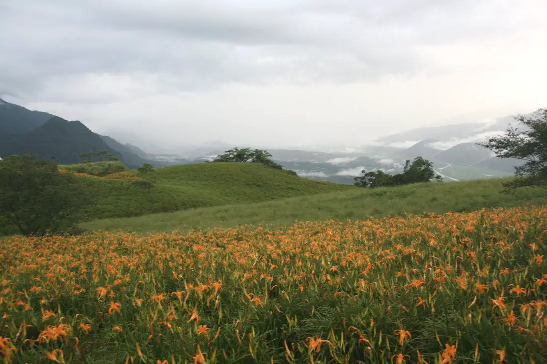
Sixty Stone mountain (aka Liushidan Mountain) is a beautiful flower and mountain landscape on the eastern flank of the eastern rift valley in Hualien County. The annual Daylily flower blooms and amazing views of the Eastern Rift Valley attract thousands of tourists each summer. Some of the picturesque and beautiful views anywhere in Taiwan can be seen from this mountain.
Background: The main crop on Sixty Stone Mountain is the Orange Daylily (aka tawny dayliliy, hemerocallis, golden needle flower, etc.). Orange Daylily is a nutrient and iron-rich plant, and is traditionally used as a garnish, spice, and preservative. In addition it is also added as raw materiel for rice paper and Chines medicine. You can buy dried bags of the stuff all over the mountain and surrounding areas. According to some of the locals, Sixty Stone Mountain gets its name from the fact that instead of producing 50 stones (or dan, measure of flowers) per field, the fields on this mountain can produce 60 stones. Other people say that it is because during the Japanese Era, all the trees were cut down and there were 60 large boulders left on the mountain. Nowadays the Mountain is a major tourist attraction, and has been highly marketed by the Taiwan tourism bureau. You can find pictures from this mountain on almost any Taiwan tourism brochure. Hours: Technically open 24/7. When to go: We suggest going during the Orange Daylily flowering season, which is from about July to September. If you go from 3-5 PM you should see an awesome view of the sunset if the weather is good. How to get there: BY Car/Scooter: Take highway 9 south from Hualien. When you reach Dongzhu, there will be a sign to Sixty Stone Mountain just after the police station. The road up the mountain is small and closes after 6:00 PM. Only cars, small vans, and scooters are allowed up the road. There are many tour groups such as KKday here and Klook here that offer van rides up the mountain. Looking for a scooter rental in Hualien? You can search KKday here or Klook here to look for options. You can also check out our scooter rental guide here. If you are looking for car rentals in Hualien, you can also search Klook here or KKDay here. You can also check out our car rental guide here. Where to stay? Most of the accommodation you will find is near the city center. If you only want to visit Hualien City and Taroko Gorge, you can consider booking a hotel near downtown, walking or cycling around the city, and taking a bus to Taroko Gorge. We have stayed at and recommend Dream Taiwan Homestay (Agoda / Booking.com), a high quality hostel for the money in downtown Hualien, Farglory Hotel (Agoda / Booking.com), right next to Farglory Ocean Park with amazing views of Hualien, and Goldenflower B&B (Agoda / Booking.com) in Yuli right next to Sixty Stone Mountain. We have also stayed at and recommend the Papago International Resort in Chishang (you can book on Agoda here / Booking.com here), which is a five star hotel with private villas with pools for each room, and Mountain and Ocean B & B in Taimali (you can book on Agoda here / Booking.com here), which is a quiet and affordable B&B right next to the beach. You can find out where to stay in our Taiwan hotels guide or search for the best hotel deals in Taiwan here. Tours: You can find more tours and activities in Hualien such as Surfing, Paragliding, SUP / Paddle Boarding, Kayaking, Canoeing, River Tracing, and much more on Klook here or KKday here. Map: Please see below: 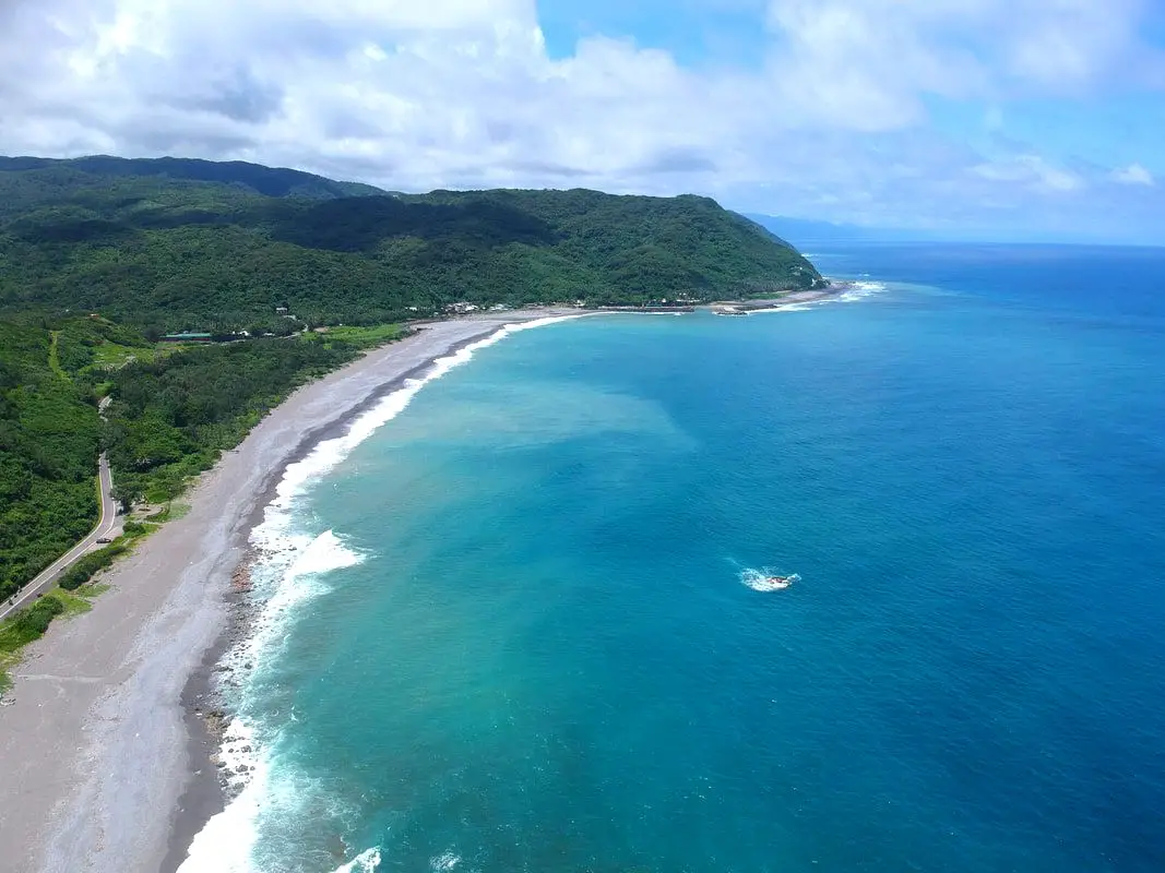
Xuhai Village is a place with amazing coastline in Mudan Township of Pingtung County. Due to its remote location, there are not many people and the landscape is mostly pristine. It may be the most beautiful stretch of coast on the main island of Taiwan.
Background: The area around Xuahi Village was originally named "Mudan Bay" because it is the site of the Mudan Incident in which nearly 100 shipwrecked Japanese sailors were massacred by local Paiwan tribespeople. The first settlers in the area arrived in the early 1900s during the Japanese era, and were mainly aboriginal people and Hakka people from other parts of Taiwan. In 1980 Xuhai Harbor was built to help the local economy and protect ships on the east coast during Typhoons. The population in the area is about half what it was in the 1980s as younger people have moved to big cities for better work opportunities. Even though there are over 450 registered households, only about 120 people regularly live here. Xuhai Village is also the start point of the Alangyi Trail 阿塱壹古道, which connects the east coast here from Pingtung to Taitung. Hours: 24/7 Price: Free Hotels: I have stayed at many hostels and hotels in Kenting, and even almost bought a house here. Some places that I have stayed at and can recommend are Nanwan Kiki (book on Agoda here, Booking.com here), a B&B next to Nanwan Bay, Kenting's most popular Beach. There are also a few decent hotels near Kenting Street Night Market like Kenting Star Inn 888 (book on Agoda here, Klook here, or Booking.com here), or Kenting Dajianshan Hotel (book on Agoda here or Booking.com here). You will notice that none of these hotels are five star resorts (I do not come to Kenting to waste my time at a resort, but you can still search Agoda or Booking.com) but they are in my opinion the above have the best value for the money. Looking for a hotel? Find out where to stay in our Taiwan hotels guide or search for the best hotel deals in Taiwan here. We recommend booking through Agoda here, which provides the best quality selection of accommodation in Taiwan. Tours and Activities in Pingtung: There are many activities available in Kenting, such as snorkeling, diving, SUPing, surfing, submarine riding, and river tracing. You can find more tours of Kenting on Klook here or KKday here. How to get there: By Bus: You can take bus 304 or 304A to Gangzai Nei station, and the sand dunes are about a half hour walk away. You can book tickets to travel to Pingtung via inter-city bus on Klook here. By Car/Scooter: Take County Highway 200 to Jiupeng in Pingtung. The sand dunes are very big and obvious along the coast. Looking for scooter rental in Pingtung? Click here or here to search for options. If you are looking for car rentals, you can also search here. By Bicycle: Cycling is the best way to enjoy Taiwan's landscapes if you have the time and energy. Looking for bicycle rentals in Taiwan? You can search on KKday here and search for tours on Klook here. You can also check out our Taiwan cycling guide here. Map: See below: 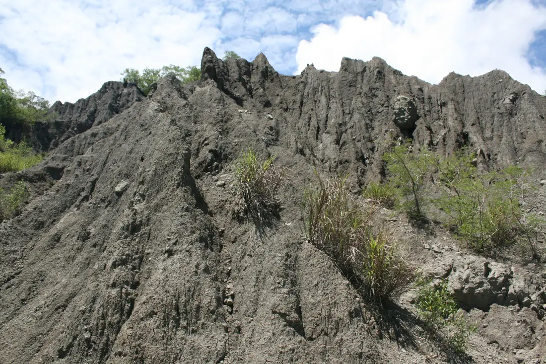
Liji Moon World (aka Liji Badlands) is a rare geological formation right next to Taitung City in eastern Taiwan (not to be confused with the larger and better Tianliao Moon World). It is composed of easily eroding clay deposits, that erode faster than plants can grow on them, creating a unique moon-like landscape. If you are in Taitung, you should take the short trip across the Beinan River and enjoy these beautiful eroding masses of clay and dirt.
Geological History: Typical badlands are found in dryer climates, are composed of sedimentary rocks, typically have very little vegetation, and have deep valleys or ravines. The badlands in Taiwan are unique in that they are in a tropical rain forest. How is this possible? The soil at Liji Badlands formed under the ocean millions of years ago, forming a layer of sediment called a melagne. Over millions of years, the land was lifted up due to plate tectonics until it became dry land. The rocks are composed of mudstone, sandstone, shale, and chalk. Because of high alkaline levels due to chalk in the soil, trees and grass cannot grow, and basically the only plant that can grow in the soil is spiny bamboo. The lack of vegetation as well as high rainfall gives way to quick eroding hills, or badlands. The Beinan River (卑南溪) also helped to carve out the landscape and bare hills. Because of the white greyish color, the hills seem to glow when in moonlight, hence the name "Moon World." However to the casual observer, the landscape looks like the surface of the moon as well. The name "Liji" comes from the name of the village where the formations are located. Price: Free! Hours: 24 hours a day! How to get there: By car/scooter: From Taitung City, take the East 45 highway out of the city, across Beinan River and the badlands will be on your right. Looking for scooter rental in Taitung? You can search Klook here or KKday here to search for options. You can also check out our scooter rental guide here. If you are looking for car rentals, you can also search KKday here or Klook here. You can check out our car rental guide here. By train: Get off at Taitung Station, and from there you can literally walk to the badlands; its only 2KM away. Alternatively you can rent a scooter or take a taxi. You can book tickets to travel to Taitung via inter-city bus on Klook here. Book tickets via the normal train (TRA) on Klook here. By plane: From Taitung Airport, hire a scooter or taxi and then take highway 11 then the East 45 Highway to the badlands. You can book discount tickets to Taitung on KKday here. You can also book cheap flights to Kinmen on Trip.com or CheapO Air. You can also search for cheap flights in Taiwan here. Accommodation: Booking accommodation in the Taitung can be difficult in the summer months and on weekends when rooms can be fully booked for months in advance. We suggest a better quality selection on Agoda.com. We have stayed at and recommend the Papago International Resort in Chishang (you can book on Agoda here, Booking.com here, Hotels.com here, or Expedia here), which is a five star hotel with private villas with pools for each room, and Mountain and Ocean B & B in Taimali (you can book on Agoda here, Booking.com here, Hotels.com here, or Expedia here), which is a quiet and affordable B&B right next to the beach. You can also book Wifi and SIM cards for Taiwan on Gigago here. Need travel insurance? Compare prices on Insubuy here. Tours: There are many companies offering snorkeling, diving, SUPing, Surfing, Speed Boating, Glamping, River tracing and other tours in Taitung. You can find more tours of Taitung on Klook here or KKday here. Just to let you know, if you book using the links above, we get some commission at no cost to you, and you can help support our blog. You can click here to receive $5 USD on your first Klook purchase. Map: Please see below: 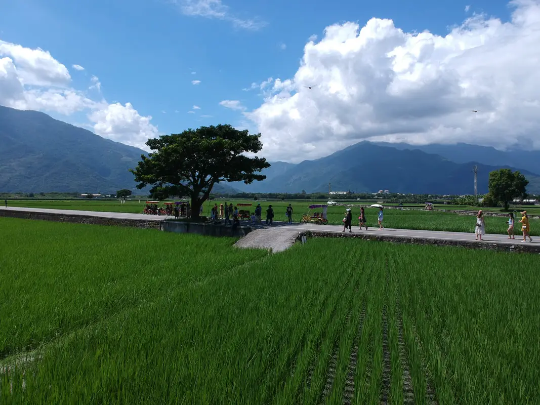
Are you a fan of rice fields, biandang, and rice in general? Chishang is the place for you! As the unofficial rice capital of Taiwan, its unspoiled views of rice fields with a backdrop of the eastern rift valley is one of the most unique and unspoiled scenic areas in Taiwan.
Historical Background: The name Chishang comes from the town being located near Dapo Pond (or Daopochi 大坡池). The area was first settled by aboriginal tribes relocated from Pingtung. Qing dynasty Chinese farmers started settling there in 1875, as a reaction to Mudan Incident of 1871 (in which a crew of shipwrecked Japanese were beheaded by Taiwan aborigines) and the Japanese punitive expedition to Taiwan in 1874. After the Japanese took control of Taiwan, Chishang's main industries were growing sugar cane and rice. A train station was completed in Chishang in 1926 as part of the eastern railway line. Because of its flat land and and abundant water, Chishang naturally became a great place for growing rice. It's rice fields and biandang (lunchbox) have generally been accepted as the best quality in Taiwan. Many of the rice varieties grown here can trace their roots to Japanese rule. Besides its unadulterated rice fields, the area also became famous due to a Mr. Brown coffee commercial shot here (at what is now know as Brown boulevard) as well an ad for EVA Air featuring Takeshi Kaneshiro (金城武)a Taiwan born Japanese actor (famous for many movies, the one which I remember him best in is the male protagonist in House of Flying Daggers), in which he drinks tea next to a tree. The tree is still there and is growing strong, although it was damaged in 2014 by typhoon Matmo. I'm not sure if this is the original Mr. Brown Coffee commercial, but its at least pretty close: 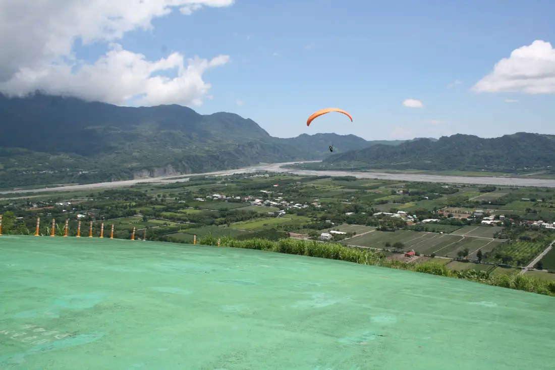
Luye Highland (aka Luye Platform, Luye Gaotai), is a hill in Taitung County's Eastern Rift Valley, and is one of the most popular spots in the country for hot air ballooning and paragliding. Every summer since 2011, the longest running hot air balloon festival in Taiwan has been held here. Even if you are not a fan of going high in the sky, the area has beautiful scenery, especially of the surrounding eastern rift valley.
Background: Luye Highland rests on a hill in Luye township of Taitung County that is about 350 meters above sea level. In 2011, the Taitung government organized the first "Taiwan International Balloon Festival" with over 350,000 people in attendance, which has been held every year since. Because the festival lasts for more than a month, according to Taiwan Everything this makes it the longest hot air balloon festival in the world. Apart from the festival, Hot Air balloons and para-gliders take off from Luye Highland year round, weather permitting. There are paragliding lessons and rides daily which you can sign up for on site. There is also a large grassy area in the center of the hill for public use, such as push car rides. How to get there: By Car: From Taipei, take National Highway 5 to Yilan, then drive south on provincial road 9 until you get to Luye. See the map below for the location of the Highlands. It will be hard to miss. Looking for scooter rental in Taitung? You can search Klook here or KKday here to search for options. You can also check out our scooter rental guide here. If you are looking for car rentals, you can also search KKday here or Klook here. You can check out our car rental guide here. By Train: Take the TRA to Luye station, and then walk, take a taxi, or take a bus to Luye Highlands (the train station is roughly 2 kilometers away from the highlands). You can book tickets to travel to Taitung via inter-city bus on Klook here. Book tickets via the normal train (TRA) on Klook here. By Plane: Fly into Taitung Airport from Taipei, then take a taxi to the highlands. You can book discount tickets to Taitung on KKday here. You can also book cheap flights to Kinmen on Trip.com or CheapO Air. You can also search for cheap flights in Taiwan here. Price: Paragliding: 1800-2500 NT Hot Air Ballooning: 500 NT and above depending on time Push Car Rides: 100 NT per ride Tethered Balloon Ride (熱氣球繫留體驗): 4PM- 6:30PM or 4:30AM to 6:30AM (July to August). The ride lasts about 5 minutes. Ticketing website: KKday or EZtravel Untethered balloon ride (熱氣球空中自由飛行): Usually between 4AM and 6AM Ticketing website: Klook Warning: Hot Air Balloons can be cancelled with short notice due to bad weather such as too much wind, rain, or influence of a Typhoon. Hours: The grounds are open 24 hours, but if you want to paraglide or ride in a hot air balloon, you should go between 8:30 am and 6:00 pm. When to Go: The Taitung balloon festival runs from June to August, which is when we recommend going. For exact dates of the festival, check here. Other than that, go when the weather is good. However, we cannot guarantee that you will be able to ride in a hot air balloon any day of the year, but it is much more likely you will be able to paraglide. Accommodation: Booking accommodation in the Taitung can be difficult in the summer months and on weekends when rooms can be fully booked for months in advance. We suggest a better quality selection on Agoda.com. We have stayed at and recommend the Papago International Resort in Chishang (you can book on Agoda here, Booking.com here, Hotels.com here, or Expedia here), which is a five star hotel with private villas with pools for each room, and Mountain and Ocean B & B in Taimali (you can book on Agoda here, Booking.com here, Hotels.com here, or Expedia here), which is a quiet and affordable B&B right next to the beach. You can also book Wifi and SIM cards for Taiwan on Gigago here. Need travel insurance? Compare prices on Insubuy here. Tours: There are many companies offering snorkeling, diving, SUPing, Surfing, Speed Boating, Glamping, River tracing and other tours in Taitung. You can find more tours of Taitung on Klook here or KKday here. Just to let you know, if you book using the links above, we get some commission at no cost to you, and you can help support our blog. You can click here to receive $5 USD on your first Klook purchase. Map: Please see below: 
Water Running Up is a gravity defying stream that appears to run uphill in Donghe Township near Dulan, Taitung County. As one of the stranger sights in Taiwan that seems to defy nature and the laws of physics, it attracts people year round. Does the water really run uphill? Let's find out.
Historical Background: Water Running up was originally built as an irrigation ditch by the Amis Aboriginal Tribe in 1870. The area around the trench was an important ritual training ground, but also a storage hub for food and water. Later on (I'm guessing in the past decade or two) people noticed that the water in the irrigation ditch appeared to run uphill when seen against a sloping background, and the Taitung County government quickly pounced on it, making it into a full fledged tourist trap. I mean tourist site. Hours: 24/7 Price: Free! You can book a tour to Taitung with Klook here or KKday here. How to get There: By Car/scooter: From Taitung, take provincial highway 11 north to Dulan. Just before you enter Dulan it will be on the left. Looking for scooter rental in Taitung? You can search Klook here or KKday here to search for options. You can also check out our scooter rental guide here. If you are looking for car rentals, you can also search KKday here or Klook here. You can check out our car rental guide here. By Train: Take the TRA to Taitung station, then take scooter or taxi via provincial highway 11 to Dulan. Book tickets via the normal train (TRA) on Klook here. By Bus: Take bus 8101 from Taitung Station to Yu Bridge. From there you will have to walk about 300 meters north, and up hill to the left. The bus ride takes just under 2 hours according to Google Maps. You can book tickets to travel to Taitung via inter-city bus on Klook here. Accommodation: Booking accommodation in the Taitung can be difficult in the summer months and on weekends when rooms can be fully booked for months in advance. We suggest a better quality selection on Agoda.com. We have stayed at and recommend the Papago International Resort in Chishang (you can book on Agoda here, Booking.com here, Hotels.com here, or Expedia here), which is a five star hotel with private villas with pools for each room, and Mountain and Ocean B & B in Taimali (you can book on Agoda here, Booking.com here, Hotels.com here, or Expedia here), which is a quiet and affordable B&B right next to the beach. You can also book Wifi and SIM cards for Taiwan on Gigago here. Need travel insurance? Compare prices on Insubuy here. ​ Tours: There are many tours and activities such as snorkeling, diving, SUPing, Surfing, Speed Boating, Glamping, River tracing and more in Taitung. You can find more tours of Taitung on Klook here or KKday here. Just to let you know, if you book using the links above, we get some commission at no cost to you, and you can help support our blog. You can click here to receive $5 USD on your first Klook purchase. ​Map: Please see below: 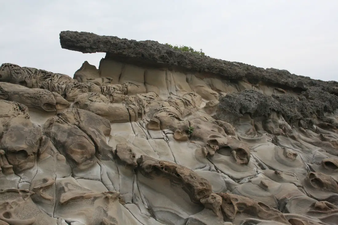
Little Yehliu (aka Xiaoyeliu) Geopark is a unique geological area on the coast of Taitung City. It bears the same name as Yeliu Geopark (famous for the Queen's Head Rock), because the rocks look similar to its more famous namesake. However Little Yehliu is much smaller as the name suggests, and its rock formations less spectacular. Despite this, it is still a beautiful and unique stretch of coastline.
Historical Background: Similar to Yehliu, the geology of Little Yehliu is made up of volcanic rock placed over sandstone. This makes for a unique structures and shapes, with large sturdy volcanic rock sitting upon easily weathered sandstone below, worn away by wind and water. Taitung County has become masterful at creating major tourist destinations out of what would normally go unnoticed, and this is no exception (for instance there are tons of this kind of coastline in northern Taiwan). Price: Parking is 50-60 NT for cars, and 15-20 NT for scooters. Otherwise entrance to the park is free. Hours: 24 hours a day How to get there: Take highway 11 from Taitung City about 6km north and it will be on your left. If you do not have a scooter or car, buses also stop along this route. Looking for scooter rental in Taitung? You can search Klook here or KKday here to search for options. You can also check out our scooter rental guide here. If you are looking for car rentals, you can also search KKday here or Klook here. You can check out our car rental guide here. You can book tickets to travel to Taitung via inter-city bus on Klook here. Book tickets via the normal train (TRA) on Klook here. Accommodation: Booking accommodation in the Taitung can be difficult in the summer months and on weekends when rooms can be fully booked for months in advance. We suggest a better quality selection on Agoda.com. We have stayed at and recommend the Papago International Resort in Chishang (you can book on Agoda here, Booking.com here, Hotels.com here, or Expedia here), which is a five star hotel with private villas with pools for each room, and Mountain and Ocean B & B in Taimali (you can book on Agoda here, Booking.com here, Hotels.com here, or Expedia here), which is a quiet and affordable B&B right next to the beach. You can also book Wifi and SIM cards for Taiwan on Gigago here. Need travel insurance? Compare prices on Insubuy here. Tours: There are many tours and activities such as snorkeling, diving, SUPing, Surfing, Speed Boating, Glamping, River tracing and more in Taitung. You can find more tours of Taitung on Klook here or KKday here. Just to let you know, if you book using the links above, we get some commission at no cost to you, and you can help support our blog. You can click here to receive $5 USD on your first Klook purchase. Map: Please see below: 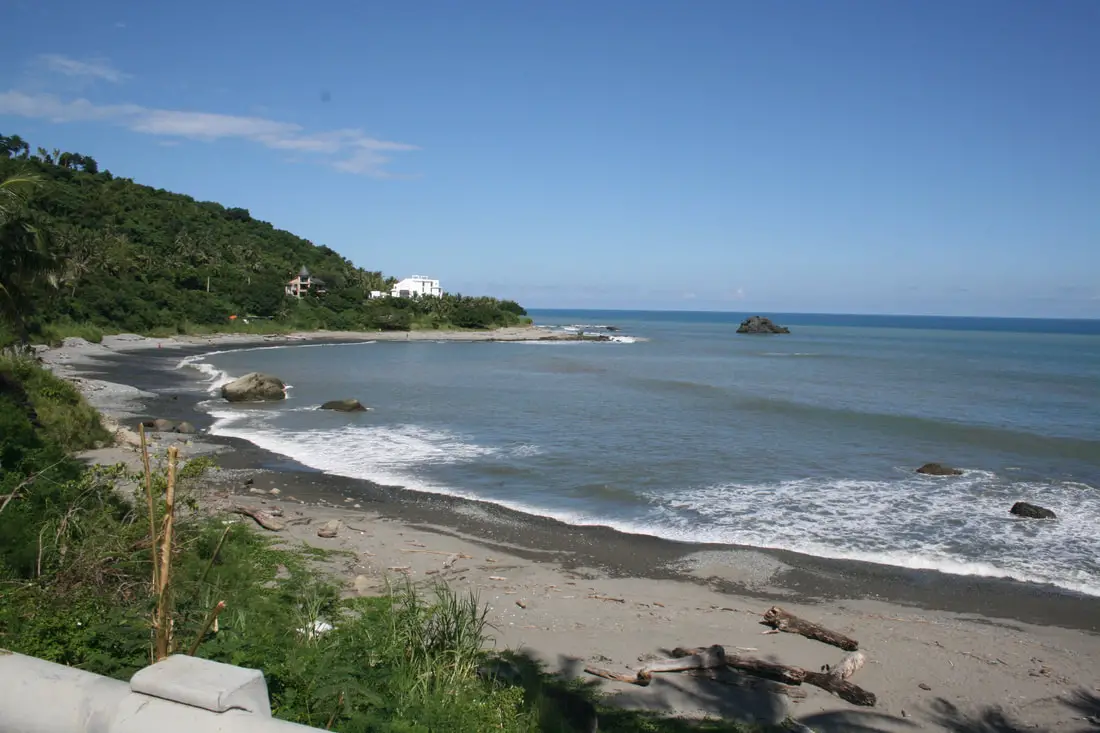
Dulan is a quiet coastal town just 20 km north of Taitung City. It has become a major surfing destination as well, especially for foreigners. Some would even say that it is the coolest beach hangout in Taiwan! There is no public transportation to Dulan other than by bus, so do not expect large crowds. It is for sure one of Taiwan's most beautiful and uncrowded seas side destinations.
Background: Dulan is a village of the Amis Aboriginie Tribe (阿美族) which have lived there since at least 1500 BC, and most of the people that live there now are Taiwan Aborigines. The area is still a center for Amis rituals and traditional ceremonies, as well as aboriginal culture. How to get there: By Car/Scooter: We recommend taking highway 11 from Taitung north 30km to the town. Feel free to stop and enjoy the scenery along the way. Looking for scooter rental in Taitung? You can search Klook here or KKday here to search for options. You can also check out our scooter rental guide here. If you are looking for car rentals, you can also search KKday here or Klook here. You can check out our car rental guide here. By Bus: You can take bus 8102 or 8103 from Taitung, but according to Google this will take about 3 hours. You can book tickets to travel to Taitung via inter-city bus on Klook here. Book tickets via the normal train (TRA) on Klook here. Accommodation: Booking accommodation in the Taitung can be difficult in the summer months and on weekends when rooms can be fully booked for months in advance. We suggest a better quality selection on Agoda.com. We have stayed at and recommend the Papago International Resort in Chishang (you can book on Agoda here, Booking.com here, Hotels.com here, or Expedia here), which is a five star hotel with private villas with pools for each room, and Mountain and Ocean B & B in Taimali (you can book on Agoda here, Booking.com here, Hotels.com here, or Expedia here), which is a quiet and affordable B&B right next to the beach. You can also book Wifi and SIM cards for Taiwan on Gigago here. Need travel insurance? Compare prices on Insubuy here. Tours: There are many tours and activities such as snorkeling, diving, SUPing, Surfing, Speed Boating, Glamping, River tracing and more in Taitung. You can find more tours of Taitung on Klook here or KKday here. Just to let you know, if you book using the links above, we get some commission at no cost to you, and you can help support our blog. You can click here to receive $5 USD on your first Klook purchase. Map: Please see the map below: 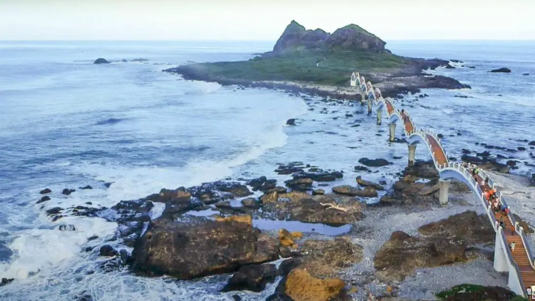
Sanxiantai is one of the most beautiful spots on the East Coast, an area full of beautiful geology and natural scenery. It is known for its iconic arching footbridge that leads to the island of the three immortals (Sanxiantai, literally three immortals platform). The ocean views and unique rock formations make it an ideal place to take a stroll and enjoy nature's beauty.
Background: Sanxiantai island is mostly made of coral and volcanic rocks. The wind and waves over time have turned the rocks into unique shapes, including tunnels, holes, and crevasses. According to Amis tribal legend, a sea dragon once lived here. According to Han Chinese legend, three of the eight immortals (Toaist Deities having power over life and evil) rested on the island, leaving three pairs of footprints. Price: Free, but parking is 50-60 NT for cars and around 15-20 NT for scooters. Hours: 24 hours a day. How to get there: From Taipei, take national highway 5 down to Yilan, then travel from Highway 9 to Hualien, then take highway 11 south along the coast. It will be on the left. Looking for scooter rental in Taitung? You can search Klook here or KKday here to search for options. You can also check out our scooter rental guide here. If you are looking for car rentals, you can also search KKday here or Klook here. You can check out our car rental guide here. Also available by bus from Hualien or Taitung, though this may take a few hours. You can book tickets to travel to Taitung via inter-city bus on Klook here. Book tickets via the normal train (TRA) on Klook here. Accommodation: Booking accommodation in the Taitung can be difficult in the summer months and on weekends when rooms can be fully booked for months in advance. We suggest a better quality selection on Agoda.com. We have stayed at and recommend the Papago International Resort in Chishang (you can book on Agoda here, Booking.com here, Hotels.com here, or Expedia here), which is a five star hotel with private villas with pools for each room, and Mountain and Ocean B & B in Taimali (you can book on Agoda here, Booking.com here, Hotels.com here, or Expedia here), which is a quiet and affordable B&B right next to the beach. You can also book Wifi and SIM cards for Taiwan on Gigago here. Need travel insurance? Compare prices on Insubuy here. Tours: There are many tours and activities such as snorkeling, diving, SUPing, Surfing, Speed Boating, Glamping, River tracing and more in Taitung. You can find more tours of Taitung on Klook here or KKday here. Just to let you know, if you book using the links above, we get some commission at no cost to you, and you can help support our blog. You can click here to receive $5 USD on your first Klook purchase. Map: Please see below: 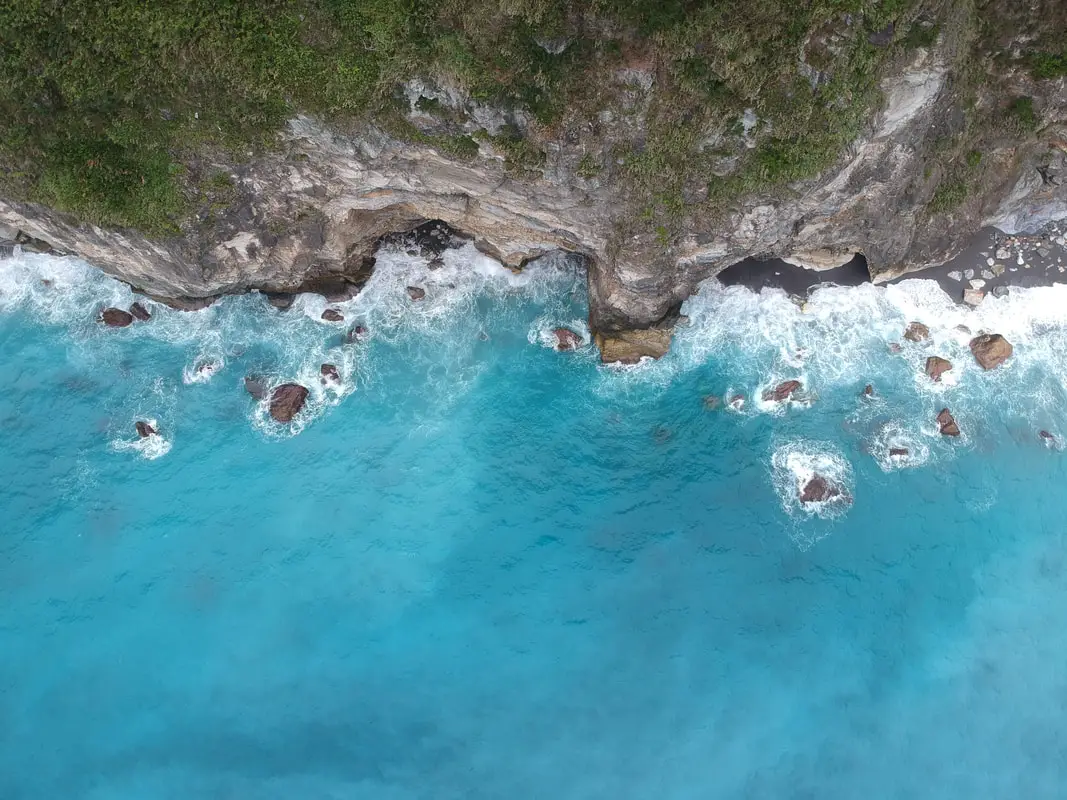
The Qingshui Cliffs in Taroko National Park on the coast of Hualien are some of the most spectacular geological features in the country, and the world. The tallest peak on the cliffs is 2,408 meters (7,900 feet) above sea level, and drops straight into the Pacific Ocean. It is a spectacular sight to behold.
Background: Taroko National Park is well known for its marble cliffs and canyons, and is also known as "The Marble Gorge." Millions of years ago, the rock we see today was sediment at the bottom of the Pacific Ocean, but oceanic and tectonic pressure turned it into limestone, and later into marble. Later the Eurasian plate was uplifted where Taiwan is today, and the cliffs were lifted out of the ocean. The cliffs are subject to constant erosion and rockslides are common. The cliffs are roughly 12 KM long and rise to over 2400 meters. They are a popular scenic stop along the Suhua highway that connects Yiland and Hualien. Hours: 24/7 Price: Free: When to visit? Hualien is great year round, but it can get a little hot in the summer, and Typhoon season and heavy rain season last from about May to October. If you are afraid of the heat and rain then you can visit during winter when the temperatures are mild and the climate is usually dryer. Where to stay? Most of the accommodation you will find is near the city center. If you only want to visit Hualien City and Taroko Gorge, you can consider booking a hotel near downtown, walking or cycling around the city, and taking a bus to Taroko Gorge. We have stayed at and recommend Dream Taiwan Homestay (Agoda / Booking.com / Expedia / Hotels.com), a high quality hostel for the money in downtown Hualien, Farglory Hotel (Agoda / Booking.com / Expedia / Hotels.com), right next to Farglory Ocean Park with amazing views of Hualien, and Goldenflower B&B (Agoda / Booking.com) in Yuli right next to Sixty Stone Mountain. You can find out where to stay in our Taiwan hotels guide or search for the best hotel deals in Taiwan here. You can also book Wifi and SIM cards for Taiwan on Gigago here. Need travel insurance? Compare prices on Insubuy here. How to get there: By Car/Scooter: From Hualien, Take highway 9 north until you reach the Qingshui Cliff lookout. There are actually a number of places to see the cliffs. Looking for a scooter rental in Hualien? You can search KKday here or Klook here to look for options. You can also check out our scooter rental guide here. If you are looking for car rentals in Hualien, you can also search Klook here or KKDay here. You can also check out our car rental guide here. By Bus: There is no public bus to the cliffs. You will have to rent a scooter or take a tour bus. Tours and Activities: You can book a SUP or kayak experience at Qingshui Cliffs and more on Klook here and KKday here. You can book tickets to travel to Hualien via inter-city bus on Klook here. Book tickets via the normal train (TRA) on Klook here. Map: See below: 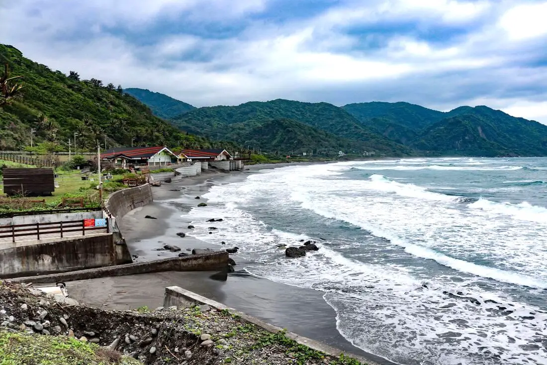
Jiqi Beach in Fengbin Township of Hualien County is one of the best surfing spots in Taiwan. This is one of the few sandy beaches on the east coast between Hualien and Taitung. It is definitely worth a visit if you are looking for an exquisite and less crowded beach.
Background: On both sides of the beach are volcanic rock formations, while the middle is sandstone and shale, which helped to form this amazing beach. Jiqi was originally called Kaluluan by the native Amis people. Originally they used the beach to dry salt, and later settled here during the Qing Dynasty, relying on fishing. Now the beach is a popular summer destination, especially for surfing. However, just a few months ago the beach closed to the public, and access is only allowed to a restaurant that charges 100 NT per person to enter. The government promises they will give access to the beach soon, but water activities may be banned forever. Hours: 24/7 (But officially closed now the the public) Price: Currently a restaurant charges 100 NT per person just to look at the beach, the government says they will allow beach access again soon How to get there: By Car/Scooter: Take highway 11 south from Hualien or north from Taitung, It is more than an hour's journey from either city. Looking for a scooter rental in Hualien? You can search KKday here or Klook here to look for options. You can also check out our scooter rental guide here. If you are looking for car rentals in Hualien, you can also search Klook here or KKDay here. You can also check out our car rental guide here. By bus: The beach can be reached by bus 1140 or 1145. You can book tickets to travel to Hualien via inter-city bus on Klook here. Book tickets via the normal train (TRA) on Klook here. Where to stay? Most of the accommodation you will find is near the city center. If you only want to visit Hualien City and Taroko Gorge, you can consider booking a hotel near downtown, walking or cycling around the city, and taking a bus to Taroko Gorge. We have stayed at and recommend Dream Taiwan Homestay (Agoda / Booking.com / Expedia / Hotels.com), a high quality hostel for the money in downtown Hualien, Farglory Hotel (Agoda / Booking.com / Expedia / Hotels.com), right next to Farglory Ocean Park with amazing views of Hualien, and Goldenflower B&B (Agoda / Booking.com) in Yuli right next to Sixty Stone Mountain. You can find out where to stay in our Taiwan hotels guide or search for the best hotel deals in Taiwan here. You can also book Wifi and SIM cards for Taiwan on Gigago here. Need travel insurance? Compare prices on Insubuy here. Tours: You can find more tours and activities in Hualien such as Surfing, Paragliding, SUP / Paddle Boarding, Kayaking, Canoeing, River Tracing, and much more on Klook here or KKday here. Map: Please see below: 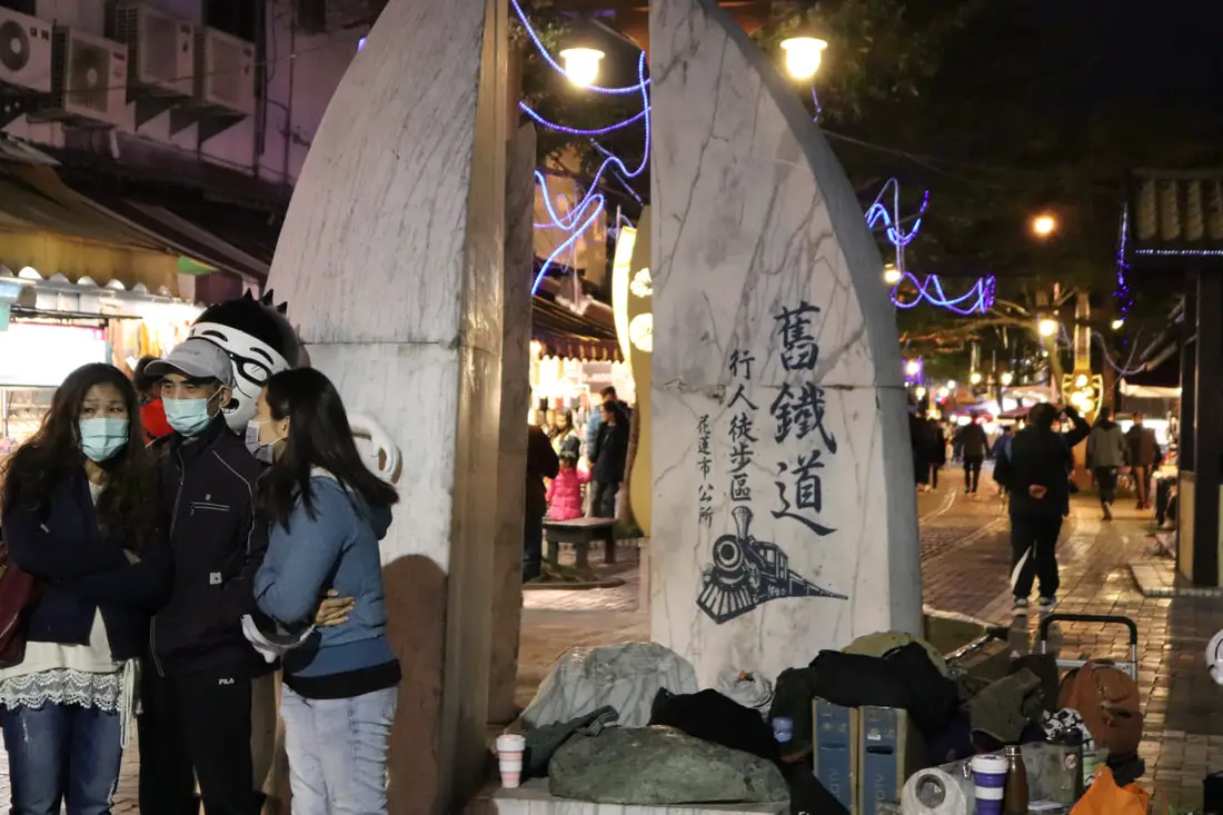
Hualien's old railway pedestrian area in the middle of the city has taken a 1.8 km old railway line and transformed into a pedestrian shopping district, much like an old street or night market. It is a worth while stroll on your next visit to Hualien.
Background: The original Hualien Train station was built over the current Dongdamen Night Market, however the railway was diverted in 1979, leaving the old railway left to rust. The old railway left is 1.8 km long and 6 m wide. In 2003, a plan was put in place to renovate the old railway into a pedestrian shopping area. Price: Free Hours: 24/7 How to get there: By Car/Scooter: The night market lies on the central eastern part of the city along Chungshan Road and Chongching Road. There is free car parking inside and free scooter parking too. Looking for a scooter rental in Hualien? You can search KKday here or Klook here to look for options. You can also check out our scooter rental guide here. If you are looking for car rentals in Hualien, you can also search Klook here or KKDay here. You can also check out our car rental guide here. By Train: From Hualien TRA station, take bus 301, or walk about 30 minutes. You can book tickets to travel to Hualien via inter-city bus on Klook here. Book tickets via the normal train (TRA) on Klook here. Where to stay? Most of the accommodation you will find is near the city center. If you only want to visit Hualien City and Taroko Gorge, you can consider booking a hotel near downtown, walking or cycling around the city, and taking a bus to Taroko Gorge. We have stayed at and recommend Dream Taiwan Homestay (Agoda / Booking.com / Expedia / Hotels.com), a high quality hostel for the money in downtown Hualien, Farglory Hotel (Agoda / Booking.com / Expedia / Hotels.com), right next to Farglory Ocean Park with amazing views of Hualien, and Goldenflower B&B (Agoda / Booking.com) in Yuli right next to Sixty Stone Mountain. You can find out where to stay in our Taiwan hotels guide or search for the best hotel deals in Taiwan here. You can also book Wifi and SIM cards for Taiwan on Gigago here. Need travel insurance? Compare prices on Insubuy here. Tours: You can find more tours and activities in Hualien on Klook here or KKday here. Map: Please see below: 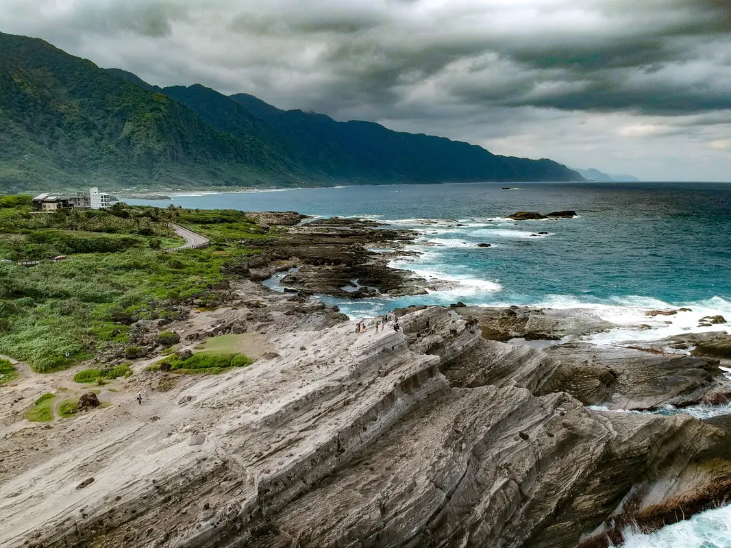
Shitiping Geopark along Taiwan’s east coast, literally meaning Stone Step Plain, because it looks like a bunch of stone steps. Some special geological forces have created this rock that resembles a bunch of stone steps on the east coast of Taiwan. Did I mention that there are stone steps? It is still a beautiful and unique stretch of coastline.
Historical Background: Shitiping literally means "rock stair plateau" get's it's name from the staircase shaped rocks along the coast. The area is made up of hard sedimentary rock placed over softer sandstone, which creates cuestas or staircase shaped rock formations. This makes for a unique structures and shapes, including potholes and trenches. Now it is a major tourist attraction along Taiwan's east coast. How to get there: Take highway 11 south from Hualien City about 60km or two and a half hours. If you do not have a scooter or car, buses also stop along this route. You can also take bus 1140A which takes about three hours. Looking for a scooter rental in Hualien? You can search KKday here or Klook here to look for options. You can also check out our scooter rental guide here. If you are looking for car rentals in Hualien, you can also search Klook here or KKDay here. You can also check out our car rental guide here. When to visit? Hualien is great year round, but it can get a little hot in the summer, and Typhoon season and heavy rain season last from about May to October. If you are afraid of the heat and rain then you can visit during winter when the temperatures are mild and the climate is usually dryer. Where to stay? Most of the accommodation you will find is near the city center. If you only want to visit Hualien City and Taroko Gorge, you can consider booking a hotel near downtown, walking or cycling around the city, and taking a bus to Taroko Gorge. We have stayed at and recommend Dream Taiwan Homestay (Agoda / Booking.com / Expedia / Hotels.com), a high quality hostel for the money in downtown Hualien, Farglory Hotel (Agoda / Booking.com / Expedia / Hotels.com), right next to Farglory Ocean Park with amazing views of Hualien, and Goldenflower B&B (Agoda / Booking.com) in Yuli right next to Sixty Stone Mountain. You can find out where to stay in our Taiwan hotels guide or search for the best hotel deals in Taiwan here. You can also book Wifi and SIM cards for Taiwan on Gigago here. Need travel insurance? Compare prices on Insubuy here. Price: Parking is 50-60 NT for cars, and 15-20 NT for scooters. Otherwise entrance to the park is free. Tours: You can book a snorkeling, SUP, or diving experience and more at Shitiping on Klook here or KKday here. Hours: 24 hours a day Map: Please see below: 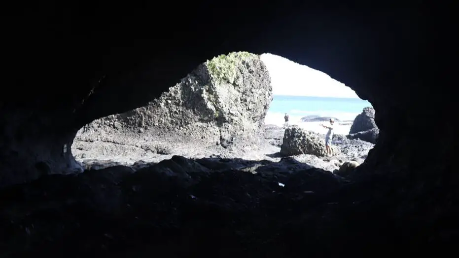
Shihmen Recreation Area (aka March Cave, Mochi Cave, Shimen, or Shimendong) is a unique geological area on the coast of Hualien County (not to be confused with Shimen in New Taipei). It is famous for it's large, car shaped cave. It is still a beautiful and unique stretch of coastline.
Historical Background: Shimen literally means "rock gate" get's it's name from the caves along the coast here. The area is made up of hard sedimentary rock placed over softer sandstone, which after thousands of years of waves from the ocean, creates unique rock formations. Now it is a major tourist attraction along Taiwan's east coast. How to get there: Take highway 11 south from Hualien City about 60km or two and a half hours. If you do not have a scooter or car, buses also stop along this route. You can also take bus 1140A which takes about three hours. Looking for a scooter rental in Hualien? You can search KKday here or Klook here to look for options. You can also check out our scooter rental guide here. If you are looking for car rentals in Hualien, you can also search Klook here or KKDay here. You can also check out our car rental guide here. Where to stay? Most of the accommodation you will find is near the city center. If you only want to visit Hualien City and Taroko Gorge, you can consider booking a hotel near downtown, walking or cycling around the city, and taking a bus to Taroko Gorge. We have stayed at and recommend Dream Taiwan Homestay (Agoda / Booking.com / Expedia / Hotels.com), a high quality hostel for the money in downtown Hualien, Farglory Hotel (Agoda / Booking.com / Expedia / Hotels.com), right next to Farglory Ocean Park with amazing views of Hualien, and Goldenflower B&B (Agoda / Booking.com) in Yuli right next to Sixty Stone Mountain. You can find out where to stay in our Taiwan hotels guide or search for the best hotel deals in Taiwan here. You can also book Wifi and SIM cards for Taiwan on Gigago here. Need travel insurance? Compare prices on Insubuy here. Price: Free Hours: 24 hours a day Tours: You can find more tours and activities in Hualien such as Surfing, Paragliding, SUP / Paddle Boarding, Kayaking, Canoeing, River Tracing, and much more on Klook here or KKday here. Map: Please see below: 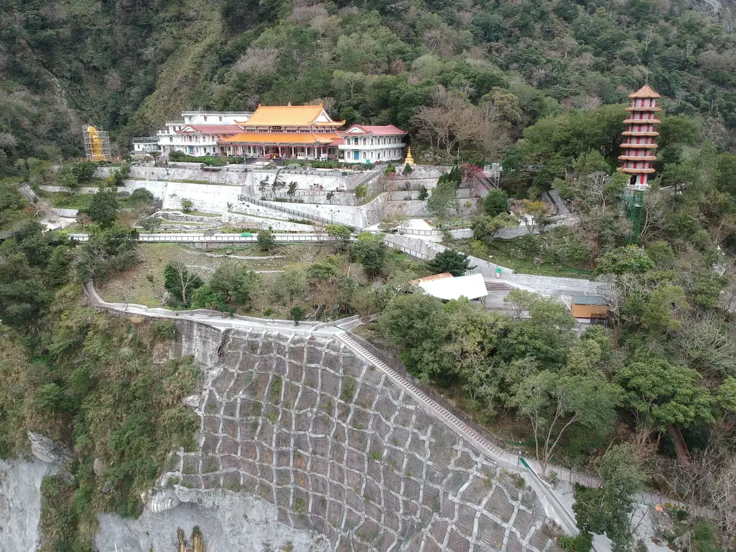
Tianxiang Recreation Area features the widest and most flat terraces within Taroko Gorge. Here you can find Xiangde Temple, Tianfeng Pagoda, Pudu Suspension Bridge, and Silks Place Taroko, which are all surrounded by amazing high canyons and beautiful deep river ravines. It is a must see spot inside Taroko Gorge.
Background: Taroko National Park is well known for its marble cliffs and canyons, and is also known as "The Marble Gorge." Millions of years ago, the rock we see today was sediment at the bottom of the Pacific Ocean, but oceanic and tectonic pressure turned it into limestone, and later into marble. Later the Eurasian plate was uplifted where Taiwan is today, and a gorge was cut out of the limestone thanks to the Liwu River. Taroko means "human being," from the Truku tribal language. Originally the Tupido Tribe settled in the area of what is now Tianxiang Taiti mesa. They built the Tupido Tribe Trail which was only 30 cm wide, and resided there until they were massacred by the Japanese in 1914. In 1917, the Japanese expanded the original trail made by the Tupido Tribe to 1.5 M and forced aboriginal tribesmen to carry goods along the trail to the east coast. This is now the Zhuilu Old Trail. Currently only 3km of the trail is open to the public. The Japanese created a national park in the Area in 1937, which was disestablished by the ROC in 1945, and then reenstated in as a national park in 1986. Tianxiang lies 455 meters above seas level, and lies at the convergence of the Dasha River and the Tazijili River, forming the Liwu River. Xiangde Temple was built in 1966 shortly after the central cross island highway was finished. It is a Buddhist monetary, and the area was chosen for it's quiet beauty. How to get there: By Car: From Taipei, Take National Highway 5 to Yilan and then drive on the Suhua Highway 9 to Hualien. A few miles before Hualien City, the gorge will be on your right. Tianxiang is 18 KM in. Looking for a scooter rental in Hualien? You can search KKday here or Klook here to look for options. You can also check out our scooter rental guide here. If you are looking for car rentals in Hualien, you can also search Klook here or KKDay here. You can also check out our car rental guide here. By Train: Take the train to Hualien station, and from there you can rent a scooter or car, or take a tour bus to the gorge, and then get off at Tianxiang. You can book tickets to travel to Hualien via inter-city bus on Klook here. Book tickets via the normal train (TRA) on Klook here. For more travel information see here. Where to stay? Most of the accommodation you will find is near the city center. If you only want to visit Hualien City and Taroko Gorge, you can consider booking a hotel near downtown, walking or cycling around the city, and taking a bus to Taroko Gorge. We have stayed at and recommend Dream Taiwan Homestay (Agoda / Booking.com / Expedia / Hotels.com), a high quality hostel for the money in downtown Hualien, Farglory Hotel (Agoda / Booking.com / Expedia / Hotels.com), right next to Farglory Ocean Park with amazing views of Hualien, and Goldenflower B&B (Agoda / Booking.com) in Yuli right next to Sixty Stone Mountain. You can find out where to stay in our Taiwan hotels guide or search for the best hotel deals in Taiwan here. You can also book Wifi and SIM cards for Taiwan on Gigago here. Need travel insurance? Compare prices on Insubuy here. Tours: You can find tours of Tianxiang on Klook here or KKday here. You can find more tours and activities in Hualien such as Surfing, Paragliding, SUP / Paddle Boarding, Kayaking, Canoeing, River Tracing, and much more on Klook here or KKday here. Hours: 24/7 Flying a Drone? Apply for a drone permit here. Price: Free! Map: Please see below: 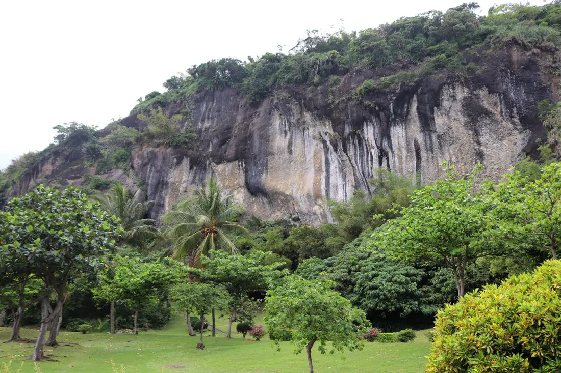
The Baxian Caves (aka Baxiandong) on the east coast in Taitung County have the earliest evidence of humans living in Taiwan, including stone tools dating back to over 30,000 years ago. In recent times the caves were converted into Taiwan folk religion temples, but now all of the 30 caves in the area have been reclaimed by the government to preserve this important archaeological site. The area is now open to the public, and there are trails and a large park in front of the caves.
Background: The Baxian Caves were originally underwater until geological forces between the Philippine and Eurasian tectonic plates forced the ground upward. The first traces of people living here date back to 30,000 years ago during the late Paleolithic age. They were thought to have crossed a land bridge between what is now Fujian Province of China and Taiwan, and created what is known as the Changbin Culture, and stayed here until about 1500 years ago during the late stone age. After that, their culture mysteriously disappeared. The people that lived in the caves were mostly hunter-gatherers that used stone tools, and used the caves as shelter. Later the area was inhabited by the Amis Aboriginie Tribe (阿美族) who have lived there since at least 1500 BC, and called the area Lohan, which means caves. After the area was settled by Han Chinese farmers, there arose a legend that the caves were home to the eight immortals (八仙 Baxian), from where the caves now get their name and many temples were built in the caves here, as well as to other gods such as the Earth God, Buddha, Guanyin, and others. Price: Free Parking: 60 NT for cars, 20 NT for scooters. You can book a tour to Taitung with Klook here or KKday here. Hours: 8:30 AM PM every day. How to get there: By Car/Scooter: We recommend taking Provincial Highway 11 from Taitung north 30km to the caves. Feel free to stop and enjoy the scenery along the way. You can also try to coming south down from Hualien. Looking for scooter rental in Taitung? You can search Klook here or KKday here to search for options. You can also check out our scooter rental guide here. If you are looking for car rentals, you can also search KKday here or Klook here. You can check out our car rental guide here. By Bus: You can take bus 8102 or 8103 from Taitung, but according to Google this will take about 3 hours. You can also try to coming south down from Hualien. You can book tickets to travel to Taitung via inter-city bus on Klook here. Book tickets via the normal train (TRA) on Klook here. Accommodation: Booking accommodation in the Taitung can be difficult in the summer months and on weekends when rooms can be fully booked for months in advance. We suggest a better quality selection on Agoda.com. We have stayed at and recommend the Papago International Resort in Chishang (you can book on Agoda here, Booking.com here, Hotels.com here, or Expedia here), which is a five star hotel with private villas with pools for each room, and Mountain and Ocean B & B in Taimali (you can book on Agoda here, Booking.com here, Hotels.com here, or Expedia here), which is a quiet and affordable B&B right next to the beach. You can also book Wifi and SIM cards for Taiwan on Gigago here. Need travel insurance? Compare prices on Insubuy here. Tours: There are many tours and activities such as snorkeling, diving, SUPing, Surfing, Speed Boating, Glamping, River tracing and more in Taitung. You can find more tours of Taitung on Klook here or KKday here. Just to let you know, if you book using the links above, we get some commission at no cost to you, and you can help support our blog. You can click here to receive $5 USD on your first Klook purchase. Map: Please see the map below: 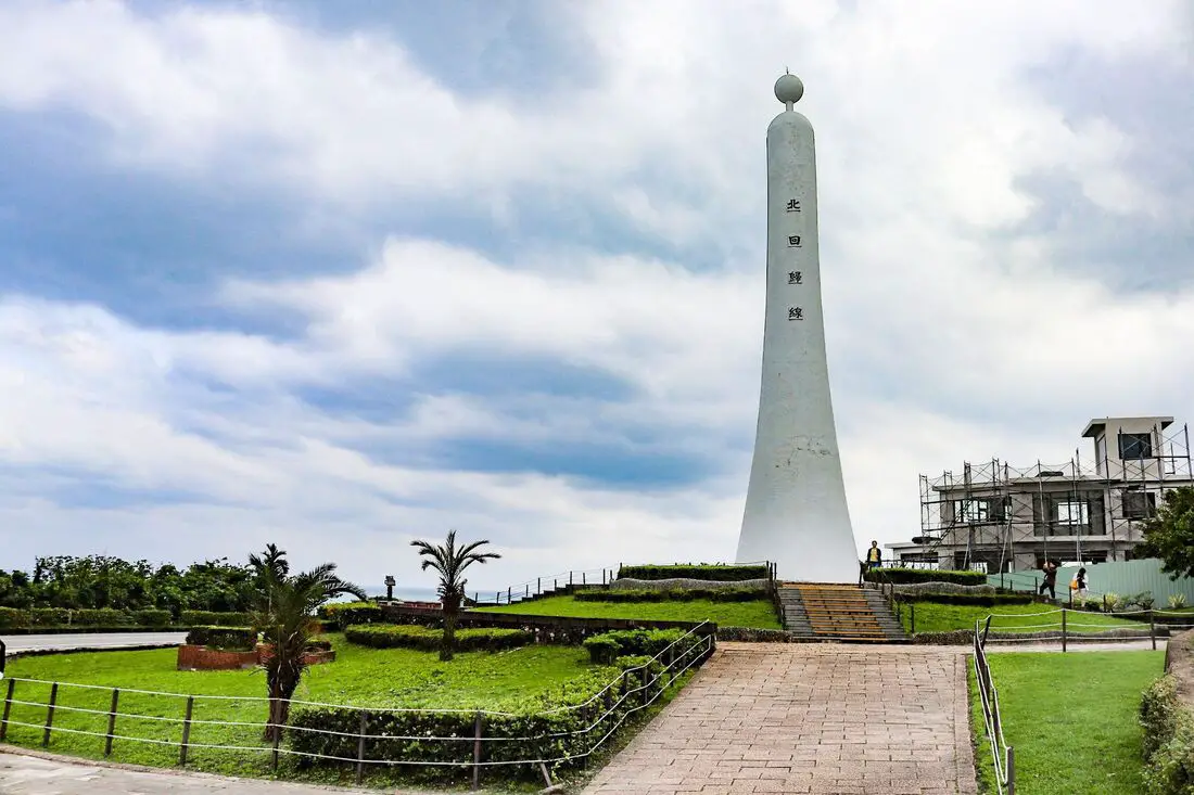
The Jingpu Tropic of Cancer Monument is a special geological marker along the road on the coast of Hualien County, and is a must stop for a selfie. There are also some fruit stands and shops nearby. It is a beautiful and unique monument to commemorate your journey around the island.
Historical Background: The Jingpu Tropic of Cancer Monument sits at 23.5 degrees N, and is the dividing line between tropical and temperate climates. You will notice that more tropical fruit grows south of here. At noon during the summer solstice, sunshine will shoot right down the black center of the monument, meaning everything will have no shadow under the sun. Jingpu has been inhabited by aboriginal peoples for thousands of years. Nearby you can enjoy local aboriginal culture, food, and enjoy the coast. How to get there: Take highway 11 south from Hualien City about 60km or two and a half hours. If you do not have a scooter or car, buses also stop along this route. You can also take bus 1140A which takes about three hours. Looking for a scooter rental in Hualien? You can search KKday here or Klook here to look for options. You can also check out our scooter rental guide here. If you are looking for car rentals in Hualien, you can also search Klook here or KKDay here. You can also check out our car rental guide here. Where to stay? Most of the accommodation you will find is near the city center. If you only want to visit Hualien City and Taroko Gorge, you can consider booking a hotel near downtown, walking or cycling around the city, and taking a bus to Taroko Gorge. We have stayed at and recommend Dream Taiwan Homestay (Agoda / Booking.com / Expedia / Hotels.com), a high quality hostel for the money in downtown Hualien, Farglory Hotel (Agoda / Booking.com / Expedia / Hotels.com), right next to Farglory Ocean Park with amazing views of Hualien, and Goldenflower B&B (Agoda / Booking.com) in Yuli right next to Sixty Stone Mountain. You can find out where to stay in our Taiwan hotels guide or search for the best hotel deals in Taiwan here. You can also book Wifi and SIM cards for Taiwan on Gigago here. Need travel insurance? Compare prices on Insubuy here. Price: Parking is free. Hours: 24 hours a day Map: Please see below: 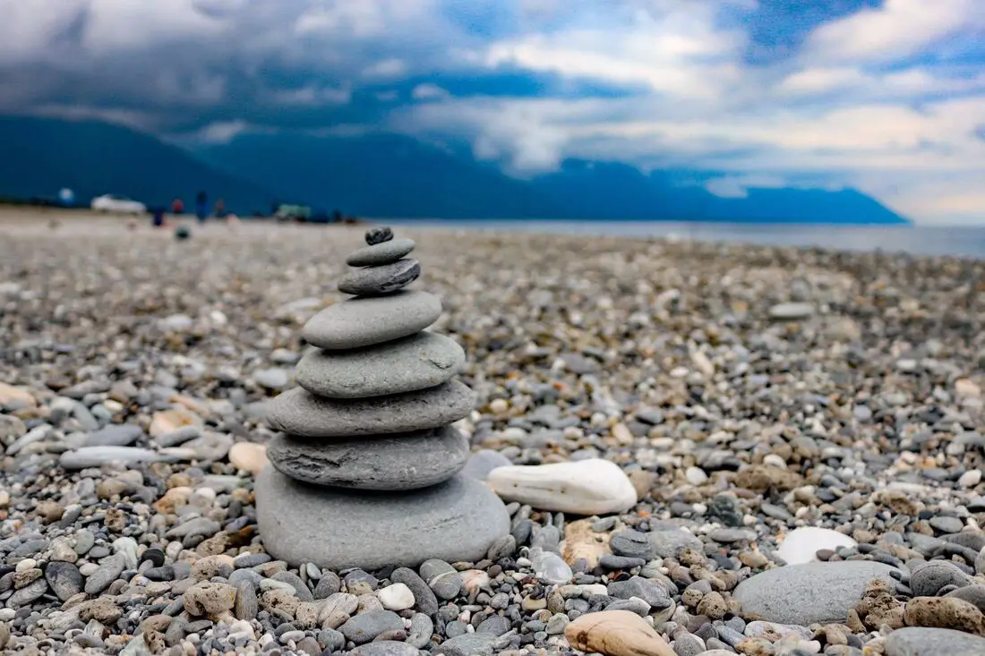
Qixingtan is the best beach in Hualien City. It is a few KM long and also features a long grassy park next to it. It is famous for its oval shaped stones which tourists like to stack together. It is definitely worth as stop on your next trip to Hualien.
Background: Qixingtan gets its name because originally it was a lake close to the seashore, that was in the shape of the Big Dipper (or Qixing 七星, seven stars). During the Japanese era, the lake was filled in in order to make an airport, which is now used by the Taiwan air force. 
https://zh.wikipedia.org/wiki/%E4%B8%83%E6%98%9F%E6%BD%AD#/media/File:Malungayangay_in_1924_map.png
Afterward, the residents instead called what before was Yueya Bay (月牙灣), a crescent beach nearby Qixingtan to honor their lost lake.
Qixingtan has now become a major tourist attraction, with thousands of visitors a year, and many hotels nearby. Hours: 24/7 Price: Free How to get there: Car/Scooter: From central Hualien, take highway 9 north until you reach past Mintou street and turn right. Keep going until you reach the beach. There is more parking at the middle and north sides. Looking for a scooter rental in Hualien? You can search KKday here or Klook here to look for options. You can also check out our scooter rental guide here. If you are looking for car rentals in Hualien, you can also search Klook here or KKDay here. You can also check out our car rental guide here. Bus: From central Hualien, you can take bus 308 to Hualien Manbo Park. The beach is just a short walk away. You can book tickets to travel to Hualien via inter-city bus on Klook here. Book tickets via the normal train (TRA) on Klook here. When to visit? Hualien is great year round, but it can get a little hot in the summer, and Typhoon season and heavy rain season last from about May to October. If you are afraid of the heat and rain then you can visit during winter when the temperatures are mild and the climate is usually dryer. Where to stay? Most of the accommodation you will find is near the city center. If you only want to visit Hualien City and Taroko Gorge, you can consider booking a hotel near downtown, walking or cycling around the city, and taking a bus to Taroko Gorge. We have stayed at and recommend Dream Taiwan Homestay (Agoda / Booking.com / Expedia / Hotels.com), a high quality hostel for the money in downtown Hualien, Farglory Hotel (Agoda / Booking.com / Expedia / Hotels.com), right next to Farglory Ocean Park with amazing views of Hualien, and Goldenflower B&B (Agoda / Booking.com) in Yuli right next to Sixty Stone Mountain. You can find out where to stay in our Taiwan hotels guide or search for the best hotel deals in Taiwan here. You can also book Wifi and SIM cards for Taiwan on Gigago here. Need travel insurance? Compare prices on Insubuy here. Tours: You can find more tours and activities in Hualien such as Surfing, Paragliding, SUP / Paddle Boarding, Kayaking, Canoeing, River Tracing, and much more on Klook here or KKday here. Map: Please see below: |
Author 作家I am an American expat who has extensive experience living, working, and traveling in Taiwan. In my day, I had to learn many things about Taiwan the hard way. But I have come to learn that Taiwan is one of the best places in the world for Foreigners to live. This blog does not represent the opinions of every foreigner in Taiwan. I am just trying to help others learn more about this beautiful country. Categories
|
 RSS Feed
