

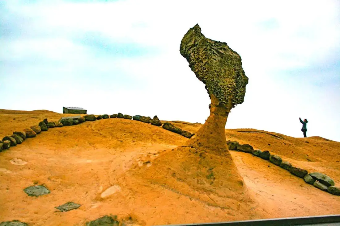
Yehliu is perhaps the most famous geological park in Taiwan, with its most famous landmark being the Queen's Head rock. These rock formations have been forming for thousands of years through erosion of soft sandstone due to wind and water. Hurry and see these formations soon before they are gone forever!
Background: The sandstone that forms the Yehliu formation was created between 10 and 20 million years ago, and was pushed out of the sea along with northern Taiwan thousands of years ago. The Queen's head is formed by two layers of sandstone, one soft fast eroding layer on bottom and a harder layer on top. This kind of sandstone formation can be seen around the world and is known as a hoodoo. The Queen's head was named after Queen Elizabeth I, because it is thought to look like her. The head is eroding .2 to .5 CM per year and is expected to fall at any time! The name Yehliu comes from the Spanish name for the area "Putno Diablos" which was then also used by the Dutch, and transliterated by the Chinese settlers in the area as "Yehliu" in Chinese. Yehliu Ocean world is the largest aquarium in northern Taiwan and has one of the few outdoor sea life amphitheaters in Taiwan. The facility features an indoor aquarium and outdoor show that is geared toward children. Hours: Yehliu Geopark: 8 AM to 5 PM in winter (tickets not sold after 4:30) 8 AM to 6 PM in summer (tickets not sold after 5:30) Yehliu Ocean World: 9 AM to 5 PM Price: Yehliu Geopark: 120 NT per person. You can book discount tickets to Yehliu Geopark on Klook here and KKday here. Yehliu Ocean World: 450 NT per person. You can book discount tickets to Yehliu Ocean World on Klook here and KKday here. You can also book tickets to the Yehliu Ocean World Parent-Child playground on Klook here. Tours: You can book a tour to Yehliu on TripAdvisor here, Klook here, or KKday here. Can I touch the rocks? Don't you dare touch the rocks! Activities along Taiwan's Northern Coast: Don't forget that there are many activities available along Taiwan's Northern Coast such as Wakeboarding, Surfing, Speedboat Surfing, SUP / Paddle Boarding, Diving, Snorkeling Kayaking, Canoeing, Water Biking, River Tracing / Canyoneering, ATVing, Horse Riding, Archery, Tree Climbing, Glamping, Motorcycling, Motorbike Tour, Dragon Boat Racing, Shen'ao Rail Bike, and more on Tripadvisor here, Klook here, or KKday here. Hotels on Taiwan's Northern Coast: We recommend Fullon Hotel which has locations in Tamsui and Fulong near the beach (book on Booking.com here, Tripadvisor here, Agoda here, or Hotels.com here). We have stayed at and recommend Gold Mountain Ranch, which is a horse ranch and glamping destination in Jinshan. You can book a night at Gold Mountain Ranch on Klook here. You can also check out our full blog on the ranch here. We have also stayed at and recommend Hai Xia Your Home which is right in front of Fulong Beach (book on Booking.com here, Tripadvisor here, Agoda here, or Hotels.com here). Looking for a hotel? We recommend booking through Booking.com here, which provides the best quality selection of accommodation in Taiwan. Find out where to stay in our Taiwan hotels guide or search for the best hotel deals in Taiwan here. How to get there: By Bus: There are inter-city buses that leave hourly from Taipei Main Station and Taipei City Hall to Yehliu. You can purchase a discount easy card to use on the MRT and buses from Klook here or KKday here. You can also book an MRT travel pass on Klook here. By Car/Scooter: Take Provincial highway 2 west out of Keelung, and keep going until you reach Wanli. The turnoff to Yehliu comes right after Wanli beach. If you are looking for car rentals, you can also search Qeeq here, Klook here, or KKday here. You can also check out our car rental guide here. Looking for scooter rental in northern Taiwan? You can search on Klook here or KKday here to search for options. You can also check out our scooter rental guide here. By Bicycle: Cycling is the best way to enjoy Taiwan's landscapes if you have the time and energy. Looking for bicycle rentals in Taiwan? You can use Taiwan's many Youbike sharing stations, or search for rentals on KKday here, and search for tours on Klook here. You can also check out our Taiwan cycling guide here. You can also book a cycling tour on TripAdvisor here. For more information, check out our Taiwan transportation guide here. Map: Please see below:
0 Comments
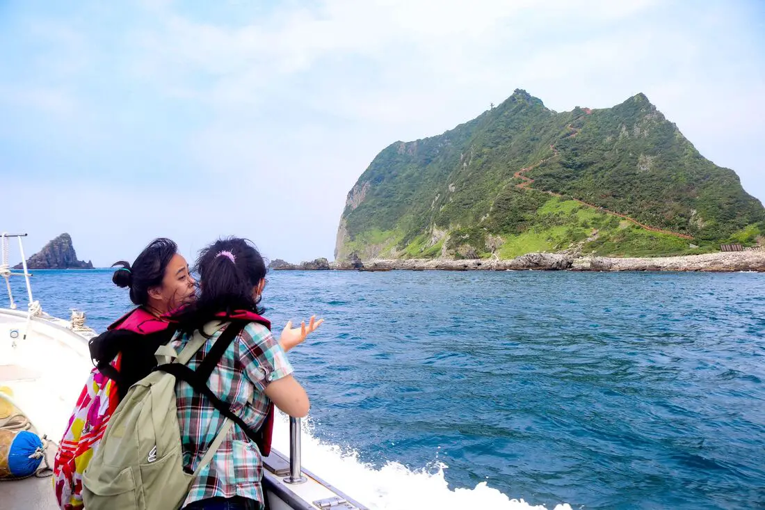
Keelung Islet is the tall, rocky island off the coast of Keelung City that has recently been reopened to tourists. The island features a trail to the lighthouse at the highest peak that provides breathtaking views of the surrounding area. Just a short trip from Taipei, and then a 20-minute boat ride, it is one of the most accessible outer islands that you can visit in Taiwan.
Background: Keelung Islet is a volcanic remnant dating back to the Pleistocene era about 1 million years ago and is part of the Ryukyu Volcanic Arc which is formed from the subduction of the Philippine Sea Plate under the Eurasian Plate. After the volcano was formed, it was slowly eroded away by wave action, creating a steep mountain peak with sides at about a 60-degree angle. The island is 182 meters tall (597 feet), 960 meters long (3139 feet), and 400 meters (1312 feet) wide. Except for crabs, birds, lizards, and insects, the island remained uninhabited until the Japanese stationed troops here during the colonization of Taiwan. After the ROC took control of Taiwan, the island continued to be a military base. In 1980, the Keelung Islet Lighthouse was completed. It was the first lighthouse in Taiwan built in an octagonal shape, and the first powered by solar power and batteries. The islet was opened to tourists in 2001, however, tourism to the island was stopped in 2014 after Typhoon Maria ravaged the island, and was closed for five years until 2019. Currently, the island is open to tourists, but you cannot stay overnight there. The only people that live on the island are members of the coast guard who stay there on a rotational basis. Tourist boats take off daily from Baodouzi Harbor from April until October, and the island is closed to tourists during the winter months due to strong northeasterly winds. The island is popular especially on weekends during the summer, but only 1200 people are allowed to visit each day, so you may have to book in advance. Hours: Boats to Keelung Islet leave at about 8 AM, with the last boats leaving at about 1 PM. Everyone has to be off the island before sundown. Each trip lasts about 3-5 hours depending on the itinerary. You can book boat tickets on Klook here or KKday here. Boats to Keelung Islet are only available from April to October due to northeasterly winds in the winter. Price: Boat trip to the island and hike to the lighthouse: about 700 NT Boat trip to the island, lighthouse, and other places such as elephant trunk rock: about 1200 NT Again, you can book tickets on Klook here or KKday here; booking on these sites is usually cheaper than buying tickets in person. When to go: Boats to Keelung Islet are only available from April to October due to northeasterly winds in the winter. If you visit from May - June you will be able to see white lily flowers, and August to September is golden spider lily season. How to get there: In order to get to Keelung Islet, you first need to make your way to Badouzi Harbor (see map below). By Car/Scooter: Drive to Keelung, then from downtown take provincial highway 2 East about 10 KM until you reach the turnoff to Badouzi Harbor, and there is some paid parking in front of the harbor. If you are looking for car rentals, you can also search Qeeq here, Klook here, or KKday here. You can also check out our car rental guide here. Looking for scooter rental in northern Taiwan? You can search on Klook here or KKday here to search for options. You can also check out our scooter rental guide here. By Train/Bus: Take the TRA to Badouzi (八斗子) station, then walk about 1 KM northwest until you reach the Badouzi Harbor. You can purchase a discount easy card to use on the MRT and buses from Klook here or KKday here. You can also book an MRT travel pass on Klook here. By Ferry: Next you have to take a boat to the island. There are multiple ferry boats running to Keelung daily from April to October. You can book tickets on Klook here or KKday here. Hotels in Keelung: We recommend Just Live Inn-Keelung and Yung Feng Hotel, which are two great quality hotels for a reasonable price in Keelung's City Center. You can book Just Live Inn-Keelung on Booking.com here, Agoda here, Klook here, Hotels.com here, Trip.com here, or Kayak here. You can book Yung Feng Hotel on Booking.com here, Agoda here, Hotels.com here, Trip.com here, Klook here, or Kayak here. Map: 
Taiwan's northern coast is an amazing, beautiful area with unique geology and rocks, lots of sandy beaches, amazing mountain views and hikes, old streets, night markets, historical sites, and much more to discover. Don't not come here.
Brief Historical Background: The sandstone that forms Northern Taiwan was created between 10 and 20 million years ago and was pushed out of the sea along with northern Taiwan thousands of years ago. Sediment under the ocean millions of years ago was uplifted thanks to the collision of the Eurasian and Philipine plates. The rocks have then been slowly eroded away by wind and water, creating odd shapes that you see today. You can see similar formations at Yehliu Geopark. What is now Keelung and Taipei was once part of Basay aborigine lands. The area around Yilan was inhabited by the Ketagalan Aboriginal tribe, whose language is now extinct. The name Yilan comes from this language. Chinese settlers from Fujian began living in the Taipei Basin during the Dutch rule in the 1600s. Keelung was first settled by the Spanish in 1626, as their first settlement in what became their rule of northern Taiwan until they were defeated by the Dutch and left Taiwan in 1642. The Qing Dynasty then ruled western Taiwan starting from the late 1600s. The capital of Taiwan was moved to Tainan. In 1891, the first train connecting Keelung and Taipei was completed. During this time, the Qing Dynasty built many forts near Keelung in response to the Opium Wars and the Sino-French War. During the Japanese Era, the capital of Taiwan was moved to Taipei and a round-island railway was completed. Currently a High-Speed Rail extension is planned for Yilan, and is expected to be completed by 2036. The northern coast of Taiwan is a popular weekend destination for the nearly 8 million people who live in the greater Taipei area. Basic Taiwan Travel Tips:
When should you go to Taiwan's Northern Coast? In my opinion, the best weather in Taipei is from March-May, and October - November, when the temperatures stay around 26 degrees Celsius and there is not as much rain. Summers are also nice, with the most sunny weather, but also hot and rainy. Winters can be cold (but not below freezing) and usually wet. Overall, there is no wrong answer as to what time of year you should visit Taipei. You will have a great time here at any time of year. Hotels on Taiwan's Northern Coast: We recommend Fullon Hotel which has locations in Tamsui and Fulong near the beach (book on Booking.com here, Tripadvisor here, Agoda here, or Hotels.com here). We have stayed at and recommend Gold Mountain Ranch, which is a horse ranch and glamping destination in Jinshan. You can book a night at Gold Mountain Ranch on Klook here. You can also check out our full blog on the ranch here. We have also stayed at and recommend Hai Xia Your Home which is right in front of Fulong Beach (book on Booking.com here, Tripadvisor here, Agoda here, or Hotels.com here). Looking for a hotel? We recommend booking through Booking.com here, which provides the best quality selection of accommodation in Taiwan. Find out where to stay in our Taiwan hotels guide or search for the best hotel deals in Taiwan here. Tours of Taiwan's Northern Coast: There are many tour itineraries that you can enjoy along Taiwan's Northern Coast that will take you to multiple destinations and arrange transportation. For more information, you can check out Tripadvisor here, KKday here, or Klook here, which are both great tour websites that can connect you with the right tour and tour guide for you. Here are some of the most popular tours of Taipei on Tripadvisor:
You can book a customized tour of Taiwan's North Coast on TripAdvisor here, Klook here, or KKday here. Attractions along Taiwan's Northern Coast: There are many attractions that you can enjoy along Taiwan's Northern Coast such as Yehliu Ocean World, Yehliu Geopark, National Museum of Marine Science and Biology, Heping Island Park, Ju Ming Museum, New Taipei Gold Museum, Futian Leisure Farm, Fort San Domingo, 13 Levels Archaeology Museum, Bat Cave, Candlestick Islet, Activities along Taiwan's Northern Coast: Don't forget that there are many activities available along Taiwan's Northern Coast such as Wakeboarding, Surfing, Speedboat Surfing, SUP / Paddle Boarding, Diving, Snorkeling Kayaking, Canoeing, Water Biking, River Tracing / Canyoneering, ATVing, Horse Riding, Archery, Tree Climbing, Glamping, Motorcycling, Motorbike Tour, Dragon Boat Racing, Shen'ao Rail Bike, and more on Tripadvisor here, Klook here, or KKday here. Just to let you know, if you book using the links above, we get some commission at no cost to you, and you can help support our blog. Some of the Klook links may not work if you are using an Ad blocker. You can click here to receive $5 USD on your first Klook purchase. How to get there: The only way to get to Taiwan is via airplane. Planes leave daily from Taipei's Songshan and Toayuan Airport. Taoyuan Airport: Taoyuan is Taiwan's largest airport and typically has cheaper flights and more flight times to choose from. It's about an hour's journey from Taoyuan Airport to the center of Taipei. You can travel via MRT, HSR, bus, or taxi to get to Taipei. You can get 30% off the Taoyuan Airport VIP lounge on KKday here. Songshan Airport: Songshan is a small airport in Taipei's city center, and can be a convenient option for people traveling within Asia. The airport is right on the Taipei MRT brown line. You can book cheap flights to Taiwan on KKday here, Trip.com here, CheapO Air here, or Kiwi here. How to get around Taiwan's Northern Coast: Northern Taiwan's transportation system is convenient and safe. There are many options you can consider to get around along Taiwan's Northern Coast below: By Train: Gets you to Keelung, Fulong, and Yilan along the north and east parts of the North Coast. Book tickets via the normal train (TRA) on Klook here. By MRT: (Mass Rapid Transit, Metro train, subway) – Easily gets you around Taipei and Tamsui. You can purchase a discount easy card to use on the MRT from Klook here or KKday here. You can also book an MRT travel pass on Klook here. By Bus: Buses run along the entire northeast coast, but they may be slow and there may not be many busses during weekdays. You can also book tickets to travel to Shifen via inter-city bus on Klook here. You can also book a Taipei Sightseeing: Hop On, Hop Off Open Top Bus on TripAdvisor here. By Taxi: You can take short rides for about 150 NT, or hire a Taxi for a day for around 150 USD. You can search for private chartered cars on KKDay here. By Car: If you are looking for car rentals, you can also search Qeeq here, Klook here, or KKday here. You can also check out our car rental guide here. By Scooter: Looking for scooter rental in northern Taiwan? You can search on Klook here or KKday here to search for options. You can also check out our scooter rental guide here. By Bicycle: Cycling is the best way to enjoy Taiwan's landscapes if you have the time and energy. Looking for bicycle rentals in Taiwan? You can use Taiwan's many Youbike sharing stations, or search for rentals on KKday here, and search for tours on Klook here. You can also check out our Taiwan cycling guide here. You can also book a cycling tour on TripAdvisor here. For more information, check out our Taiwan transportation guide here. Here is a map of the locations we will cover in this blog: 
Taipei is full of very accessible hikes right next to the city center. You can find amazing views of Taipei City, as well as make some adrenaline pumping hikes up some very steep peaks in New Taipei and Keelung. We highly recommend checking out what hikes Taipei has to offer. In this guide, we will list out some of the most amazing hikes around Taipei.
Safety Tips When Hiking in Taipei:
Basic Taipei Travel Tips:
When should you go to Taipei? In my opinion, the best weather in Taipei is from March-May, and October - November, when the temperatures stay around 26 degrees Celsius and there is not as much rain. Summers are also nice, with the most sunny weather, but also hot and rainy. Winters can be cold (but not below freezing) and usually wet. Overall, there is no wrong answer as to what time of year you should visit Taipei. You will have a great time here at any time of year. Hotels in Taipei: High end: We have stayed at and recommend the Yuanshan Grand Hotel, once the tallest building in Taiwan and still the most grand (book on Booking.com here, Tripadvisor here, or Agoda here). We have also stayed at and recommend the Grand Hyatt (book on Booking.com here, Tripadvisor here, Agoda here, or Hotels.com here), Marriot (book on Booking.com here, Tripadvisor here, Agoda here, or Hotels.com here), Sheraton (book on Booking.com here, Tripadvisor here, Agoda here, or Hotels.com here), Shangri-la (book on Booking.com here, Tripadvisor here, Agoda here, or Hotels.com here), and Regent (book on Booking.com here, Tripadvisor here, Agoda here, or Hotels.com here), which are all very high quality hotels in the middle of Taipei City. We also recommend Fullon Hotel which has locations in Tamsui and Fulong near the beach (book on Booking.com here, Tripadvisor here, Agoda here, or Hotels.com here). Budget Hotels: We have stayed at and recommend and also Fu Chang Hotel in Ximending, which is within walking distance of Ximending shopping district (book on Booking.com here, Tripadvisor here, or Agoda here). We have also stayed at and recommend Hai Xia Your Home which is right in front of Fulong Beach (book on Booking.com here, Tripadvisor here, Agoda here, or Hotels.com here). Looking for a hotel? We recommend booking through Booking.com here, which provides the best quality selection of accommodation in Taiwan. Find out where to stay in our Taiwan hotels guide or search for the best hotel deals in Taiwan here. Tours in Taipei: There are many tour itineraries that you can enjoy in Taipei that will take you to multiple destinations and arrange transportation. For more information, you can check out Tripadvisor here, KKday here or Klook here, which are both great tour websites that can connect you with the right tour and tour guide for you. Here are some of the post popular tours of Taipei on Tripadvisor:
Attractions in Taipei: There are many attractions that you can enjoy in Taipei such as Taipei 101 Observatory, Taipei 101 460 Skyline Observatory, Taipei Children's Amusement Park, Maokong Gondola, National Palace Museum, Yehliu Ocean World, Yehliu Geopark, National Museum of Marine Science and Biology, i-ride 5D cinema, Astronomical Museum, Miniatures Museum of Taiwan, Double Decker Sightseeing Bus, Miramar Ferris Wheel Ticket, Taipei Zoo, Heping Island Park, Ju Ming Museum, Yuanshan Hotel Secret Road, National Taiwan Museum, New Taipei Gold Museum, Futian Leisure Farm, Chiang Kai-shek Shilin Residence, Chi Po-lin Museaum, Beitou Museum, Tsao Wonderland, Railway Museum, Fort San Domingo, 13 Levels Archaeology Museum, Austin Land, Museum of World Religions, Formosan Aboriginies Museum, ASE Parent-child Park, teamLab Future Park, Yukids Island, VR Experience, Bat Cave, Neidong Waterfall, Candlestick Islet, Jurassic Snow Park, Zhonghe High5 Amusement Park, Longshan Temple, Xingtian Temple, Ningxia Night Market, Yansan Night Market, Meteor Garden, Yingge Old Street, and many more attractions on Tripadvisor here, Klook here, or KKday here. Activities in Taipei: Indoor Skiing, Rock Climbing, Hiking, Wakeboarding, Surfing, Speedboat Surfing, SUP / Paddle Boarding, Diving, Snorkeling Kayaking, Canoeing, Water Biking, River Tracing / Canyoneering, ATVing, Horse Riding, Cooking Class, Archery, Ice Skating, Roller Skating, Tree Climbing, Urban Camping, Glamping, Motorcycling, Motorbike Tour, Dragon Boat Racing, Escape Room, Shen'ao Rail Bike, Laser Gun Experience, Batting Cages, Bowling, Paintball, Flight Simulation Experience, Taipei Tram Driving Experience, Rail Simulation Experience, Taipei 101 Observation Deck activity, Strawberry Picking, Professional Photo Shoot, Body Relaxation SPA, Night Tour, Calligraphy Workshop rand more on Tripadvisor here, Klook here, or KKday here. Just to let you know, if you book using the links above, we get some commission at no cost to you, and you can help support our blog. Some of the Klook links may not work if you are using an Ad blocker. You can click here to receive $5 USD on your first Klook purchase. How to get there: The only way to get to Taiwan is via airplane. Planes leave daily from Taipei's Songshan and Toayuan Airport. Taoyuan Airport: Taoyuan is Taiwan's largest airport and typically has cheaper flights and more flight times to choose from. It's about an hour's journey from Taoyuan Airport to the center of Taipei. You can travel via MRT, HSR, bus, or taxi to get to Taipei. You can get 30% off the Taoyuan Airport VIP lounge on KKday here. Songshan Airport: Songshan is a small airport in Taipei's city center, and can be a convenient option for people traveling within Asia. The airport is right on the Taipei MRT brown line. You can book cheap flights to Taiwan on KKday here, Trip.com here, CheapO Air here, or Kiwi here. How to get around in Taipei: Taipei's transportation system is convenient and safe. There are many options you can consider to get around in Taipei below: By Train: Gets you to the city center of all major cities in Taiwan. It is about 800NT to get from Taipei to Kaohsiung. Roughly half the price of the HSR. Book tickets via the normal train (TRA) on Klook here. By HSR: (High-Speed Rail) – Gets you quickly from north to south. Besides Taipei and Kaohsiung, most of the stations are far from city centers. It costs about 1500NT to get from Taipei to Kaohsiung. You can book tickets to the high-speed rail (HSR) on Klook here or KKDay here. By MRT: (Mass Rapid Transit, Metro train, subway) – Easily gets you around Taipei and Kaohsiung. You can also book an MRT travel pass on Klook here. By Bus: Buses can be tricky. Long-range buses such as Ubus and King Bus are easier to understand and cheaper than the local train. They can take you to the city center of every city throughout Taiwan and to remote tourist destinations such as sun moon lake. A long-range bus from Taipei to Kaohsiung is about 500 NT. You can also book tickets to travel to Shifen via inter-city bus on Klook here. You can also book a Taipei Sightseeing: Hop On, Hop Off Open Top Bus on TripAdvisor here. By Taxi: You can take short rides for about 150 NT, or hire a Taxi for a day for around 150 USD. By Car: If you are looking for car rentals, you can also search Qeeq here, Klook here, or KKday here. You can also check out our car rental guide here. By Scooter: Looking for scooter rental in Taipei? Click here or here to search for options. You can also check out our scooter rental guide here. By Bicycle: Cycling is the best way to enjoy Taiwan's landscapes if you have the time and energy. Looking for bicycle rentals in Taiwan? You can use Taiwan's many Youbike bike sharing stations, or search for rentals on KKday here, and search for tours on Klook here. You can also check out our Taiwan cycling guide here. You can also book a Sunset Riverside Bike Ride and Historical Tour, 4 Hour Cycling in Taipei, Ultimate 8-Hour Cycling City Tour, or Taipei City Bike Tour with Night Market Experience on TripAdvisor here. For more information, check out our Taiwan transportation guide here. Tourist Site Map: Check out our map below of tourist sites in Taiwan, which is constantly updated: 
Taipei is full of fund places and activities for kids. In the past few years, more and more fun parks, restaurants, museums, and theme parks have opened. In this blog, we will show you some of the funnest activities and places around Taipei that are fun for kids.
Tips For Travelling in Taipei with Kids:
Basic Taipei Travel Tips:
When should you go to Taipei? In my opinion, the best weather in Taipei is from March-May, and October - November, when the temperatures stay around 26 degrees Celsius and there is not as much rain. Summers are also nice, with the most sunny weather, but also hot and rainy. Winters can be cold (but not below freezing) and usually wet. Overall, there is no wrong answer as to what time of year you should visit Taipei. You will have a great time here at any time of year. Hotels in Taipei: High end: We have stayed at and recommend the Yuanshan Grand Hotel, once the tallest building in Taiwan and still the most grand (book on Booking.com here, Tripadvisor here, or Agoda here). We have also stayed at and recommend the Grand Hyatt (book on Booking.com here, Tripadvisor here, Agoda here, or Hotels.com here), Marriot (book on Booking.com here, Tripadvisor here, Agoda here, or Hotels.com here), Sheraton (book on Booking.com here, Tripadvisor here, Agoda here, or Hotels.com here), Shangri-la (book on Booking.com here, Tripadvisor here, Agoda here, or Hotels.com here), and Regent (book on Booking.com here, Tripadvisor here, Agoda here, or Hotels.com here), which are all very high quality hotels in the middle of Taipei City. We also recommend Fullon Hotel which has locations in Tamsui and Fulong near the beach (book on Booking.com here, Tripadvisor here, Agoda here, or Hotels.com here). Budget Hotels: We have stayed at and recommend and also Fu Chang Hotel in Ximending, which is within walking distance of Ximending shopping district (book on Booking.com here, Tripadvisor here, or Agoda here). We have also stayed at and recommend Hai Xia Your Home which is right in front of Fulong Beach (book on Booking.com here, Tripadvisor here, Agoda here, or Hotels.com here). Looking for a hotel? We recommend booking through Booking.com here, which provides the best quality selection of accommodation in Taiwan. Find out where to stay in our Taiwan hotels guide or search for the best hotel deals in Taiwan here. Tours in Taipei: There are many tour itineraries that you can enjoy in Taipei that will take you to multiple destinations and arrange transportation. For more information, you can check out Tripadvisor here, KKday here or Klook here, which are both great tour websites that can connect you with the right tour and tour guide for you. Here are some of the post popular tours of Taipei on Tripadvisor:
Attractions in Taipei: There are many attractions that you can enjoy in Taipei such as Taipei 101 Observatory, Taipei 101 460 Skyline Observatory, Taipei Children's Amusement Park, Maokong Gondola, National Palace Museum, Yehliu Ocean World, Yehliu Geopark, National Museum of Marine Science and Biology, i-ride 5D cinema, Astronomical Museum, Miniatures Museum of Taiwan, Double Decker Sightseeing Bus, Miramar Ferris Wheel Ticket, Taipei Zoo, Heping Island Park, Ju Ming Museum, Yuanshan Hotel Secret Road, National Taiwan Museum, New Taipei Gold Museum, Futian Leisure Farm, Chiang Kai-shek Shilin Residence, Chi Po-lin Museaum, Beitou Museum, Tsao Wonderland, Railway Museum, Fort San Domingo, 13 Levels Archaeology Museum, Austin Land, Museum of World Religions, Formosan Aboriginies Museum, ASE Parent-child Park, teamLab Future Park, Yukids Island, VR Experience, Bat Cave, Neidong Waterfall, Candlestick Islet, Jurassic Snow Park, Zhonghe High5 Amusement Park, Longshan Temple, Xingtian Temple, Ningxia Night Market, Yansan Night Market, Meteor Garden, Yingge Old Street, and many more attractions on Tripadvisor here, Klook here, or KKday here. Activities in Taipei: Indoor Skiing, Rock Climbing, Hiking, Wakeboarding, Surfing, Speedboat Surfing, SUP / Paddle Boarding, Diving, Snorkeling Kayaking, Canoeing, Water Biking, River Tracing / Canyoneering, ATVing, Horse Riding, Cooking Class, Archery, Ice Skating, Roller Skating, Tree Climbing, Urban Camping, Glamping, Motorcycling, Motorbike Tour, Dragon Boat Racing, Escape Room, Shen'ao Rail Bike, Laser Gun Experience, Batting Cages, Bowling, Paintball, Flight Simulation Experience, Taipei Tram Driving Experience, Rail Simulation Experience, Taipei 101 Observation Deck activity, Strawberry Picking, Professional Photo Shoot, Body Relaxation SPA, Night Tour, Calligraphy Workshop rand more on Tripadvisor here, Klook here, or KKday here. Just to let you know, if you book using the links above, we get some commission at no cost to you, and you can help support our blog. Some of the Klook links may not work if you are using an Ad blocker. You can click here to receive $5 USD on your first Klook purchase. How to get there: The only way to get to Taiwan is via airplane. Planes leave daily from Taipei's Songshan and Toayuan Airport. Taoyuan Airport: Taoyuan is Taiwan's largest airport and typically has cheaper flights and more flight times to choose from. It's about an hour's journey from Taoyuan Airport to the center of Taipei. You can travel via MRT, HSR, bus, or taxi to get to Taipei. You can get 30% off the Taoyuan Airport VIP lounge on KKday here. Songshan Airport: Songshan is a small airport in Taipei's city center, and can be a convenient option for people traveling within Asia. The airport is right on the Taipei MRT brown line. You can book cheap flights to Taiwan on KKday here, Trip.com here, CheapO Air here, or Kiwi here. How to get around in Taipei: Taipei's transportation system is convenient and safe. There are many options you can consider to get around in Taipei below: By Train: Gets you to the city center of all major cities in Taiwan. It is about 800NT to get from Taipei to Kaohsiung. Roughly half the price of the HSR. Book tickets via the normal train (TRA) on Klook here. By HSR: (High-Speed Rail) – Gets you quickly from north to south. Besides Taipei and Kaohsiung, most of the stations are far from city centers. It costs about 1500NT to get from Taipei to Kaohsiung. You can book tickets to the high-speed rail (HSR) on Klook here or KKDay here. By MRT: (Mass Rapid Transit, Metro train, subway) – Easily gets you around Taipei and Kaohsiung. You can also book an MRT travel pass on Klook here. By Bus: Buses can be tricky. Long-range buses such as Ubus and King Bus are easier to understand and cheaper than the local train. They can take you to the city center of every city throughout Taiwan and to remote tourist destinations such as sun moon lake. A long-range bus from Taipei to Kaohsiung is about 500 NT. You can also book tickets to travel to Shifen via inter-city bus on Klook here. You can also book a Taipei Sightseeing: Hop On, Hop Off Open Top Bus on TripAdvisor here. By Taxi: You can take short rides for about 150 NT, or hire a Taxi for a day for around 150 USD. By Car: If you are looking for car rentals, you can also search Qeeq here, Klook here, or KKday here. You can also check out our car rental guide here. By Scooter: Looking for scooter rental in Taipei? Click here or here to search for options. You can also check out our scooter rental guide here. By Bicycle: Cycling is the best way to enjoy Taiwan's landscapes if you have the time and energy. Looking for bicycle rentals in Taiwan? You can use Taiwan's many Youbike bike sharing stations, or search for rentals on KKday here, and search for tours on Klook here. You can also check out our Taiwan cycling guide here. You can also book a Sunset Riverside Bike Ride and Historical Tour, 4 Hour Cycling in Taipei, Ultimate 8-Hour Cycling City Tour, or Taipei City Bike Tour with Night Market Experience on TripAdvisor here. For more information, check out our Taiwan transportation guide here. Tourist Site Map: Check out our map below of tourist sites in Taiwan, which is constantly updated: 
Keelung is a small city in the northern part of Taiwan, known for its deep harbor. Here you can find interesting historical sites dating back to the Dutch, Spanish, Qing, and Japanese colonization of Taiwan. Now the town is a bustling urban area with tons of food options, amazing coastline, waterfalls, mountains, and much more to explore. It should definitely be on your bucket list of places to visit in Taiwan.
Brief Historical Background of Keelung: Keelung was formed as sediment under the ocean millions of years ago and was then uplifted thanks to the collision of the Eurasian and Phillipine plates. The rocks have then been slowly eroded away by wind and water, creating odd shapes that you see today. You can see similar formations at Yehliu Geopark. What is now Keelung was once part of Basay aborigine lands. Keelung was first settled by the Spanish in 1626 because of the deep-watered Keelung Harbor. Their first settlement in what became their rule of northern Taiwan until they were defeated by the Dutch and left Taiwan in 1642 was on Heping Island. They built Fort San Salvador (聖薩爾瓦多城), which was destroyed and abandoned by the Dutch in 1668. The ruins of the fort were not confirmed to be found on the island until excavations in 2019. In 1891, the first train connecting Keelung and Taipei was completed. During this time, the Qing Dynasty built many forts near Keelung in response to the Opium Wars and the Sino-French War. During the Japanese Era, the capital of Taiwan was moved to Taipei and a round-island railway was completed. After WWII, as part of the White Terror Movement, on March 8th, 1947 KMT soldiers kidnapped and shot some of about 30 civilians on Sheliao island who were suspected enemy conspirators, known as the Sheliao Incident "社寮事件." After this, the people on the island decided to change to island's name to "Peace Island" or Heping Island in Chinese. Keelung is now a popular daytime and weekend destination for many Taiwanese. Basic Keelung Travel Tips:
When should you go to Keelung? In my opinion, the best weather in Keelung is from March-May, and October - November, when the temperatures stay around 26 degrees Celsius and there is not as much rain. Summers are also nice, with the most sunny weather, but also hot and rainy. Winters can be cold (but not below freezing) and usually wet. Overall, there is no wrong answer as to what time of year you should visit Keelung. You will have a great time here at any time of year. Hotels in Keelung: We recommend Just Live Inn-Keelung and Yung Feng Hotel, which are two great quality hotels for a reasonable price in Keelung's City Center. You can book Just Live Inn-Keelung on Booking.com here, Agoda here, Klook here, Hotels.com here, Trip.com here, or Kayak here. You can book Yung Feng Hotel on Booking.com here, Agoda here, Hotels.com here, Trip.com here, Klook here, or Kayak here. Looking for a hotel? We recommend booking through Booking.com here, which provides the best quality selection of accommodation in Taiwan. Find out where to stay in our Taiwan hotels guide or search for the best hotel deals in Taiwan here. Tours near Keelung: There are many tour itineraries that you can enjoy in Keelung that will take you to multiple destinations and arrange transportation. For more information, you can check out Tripadvisor here, KKday here or Klook here, which are both great tour websites that can connect you with the right tour and tour guide for you. Here are some of the most popular tours of Taipei on Tripadvisor:
Attractions around Keelung: There are many attractions that you can enjoy in Keelung such as Heping Island Park, Miaokou Night Market, Chaojing Smart Aquarium, Kanziding Fish Market, National Museum of Marine Science and Biology, Yehliu Ocean World, Yehliu Geopark, Jiufen, Elephant Trunk Rock, Ju Ming Museum, New Taipei Gold Museum, Bat Cave, Candlestick Islet, and many more attractions on Tripadvisor here, Klook here, or KKday here. Activities in Keelung: Don't forget that there are many activities available in Keelung such as Yachting, Fishing, Surfing, SUP / Paddle Boarding, Diving, Snorkeling Kayaking, Canoeing, Water Biking, River Tracing / Canyoneering, Glamping, Motorcycling, Motorbike Tour, Shen'ao Rail Bike, Night Fishing, Instagram Tour, Metaverse VR experience, Seaside Picnic, and more on Tripadvisor here, Klook here, or KKday here. Just to let you know, if you book using the links above, we get some commission at no cost to you, and you can help support our blog. Some of the Klook links may not work if you are using an Ad blocker. You can click here to receive $5 USD on your first Klook purchase. How to get there: The only way to get to Taiwan is via airplane. Planes leave daily from Taipei's Songshan and Toayuan Airport. Taoyuan Airport: Taoyuan is Taiwan's largest airport and typically has cheaper flights and more flight times to choose from. It's about an hour's journey from Taoyuan Airport to the center of Taipei. You can travel via MRT, HSR, bus, or taxi to get to Taipei. You can get 30% off the Taoyuan Airport VIP lounge on KKday here. Songshan Airport: Songshan is a small airport in Taipei's city center, and can be a convenient option for people traveling within Asia. The airport is right on the Taipei MRT brown line. You can book cheap flights to Taiwan on KKday here, Trip.com here, CheapO Air here, or Kiwi here. How to get around in Keelung: Taipei's transportation system is convenient and safe. There are many options you can consider to get around in Taipei below: By Train: Gets you to the city center of all major cities in Taiwan. It is about 800NT to get from Taipei to Kaohsiung. Roughly half the price of the HSR. Book tickets via the normal train (TRA) on Klook here. By Bus: Long-range buses such as Ubus and King Bus are easier to understand and cheaper than the local train. You can book tickets to travel to Keelung via inter-city bus on Klook here. By Taxi: You can take short rides for about 150 NT, or hire a Taxi for a day for around 150 USD. You can search for private chartered cars on KKDay here. By Car: If you are looking for car rentals, you can also search Qeeq here, Klook here, or KKday here. You can also check out our car rental guide here. By Scooter: Looking for scooter rental in Taipei? Search KKday here for options. You can also check out our scooter rental guide here. By Bicycle: Cycling is the best way to enjoy Taiwan's landscapes if you have the time and energy. Looking for bicycle rentals in Taiwan? You can use Taiwan's many Youbike bike sharing stations, or search for rentals on KKday here, and search for tours on Klook here. You can also check out our Taiwan cycling guide here. For more information, check out our Taiwan transportation guide here. Tourist Site Map: Check out our map below of tourist sites in Taiwan, which is constantly updated: 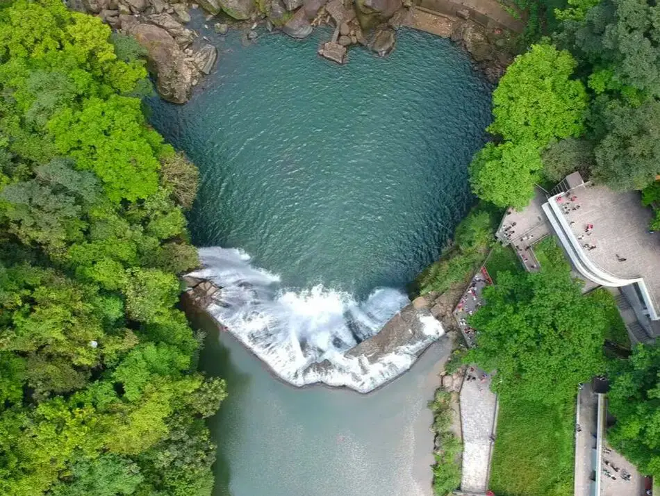
Taipei is home to some of Taiwan's most magnificent waterfalls, and most of them are just a short trip away. Here we have compiled a list of the most easily accessible waterfalls around Taipei.
Please note this is not an exhaustive list. There are many more waterfalls in Taipei than are listed in this blog. Get out there and discover Taipei's waterfalls for yourself! Safety Tips When Visiting Waterfalls:
Basic Taipei Travel Tips:
When should you go to Taipei? In my opinion, the best weather in Taipei is from March-May, and October - November, when the temperatures stay around 26 degrees Celsius and there is not as much rain. Summers are also nice, with the most sunny weather, but also hot and rainy. Winters can be cold (but not below freezing) and usually wet. Overall, there is no wrong answer as to what time of year you should visit Taipei. You will have a great time here at any time of year. Hotels in Taipei: We have stayed at and recommend the Yuanshan Grand Hotel, once the tallest building in Taiwan and still the most grand (book on Booking.com here, Agoda here, or Kayak here). We also recommend Fullon Hotel which has locations in Tamsui and Fulong near the beach (book on Booking.com here, Agoda here, or Kayak here). Budget Hotels: We have stayed at and also recommend Fu Chang Hotel in Ximending, which is within walking distance of Ximending shopping district (book on Booking.com here, Agoda here, or Kayak here). We have also stayed at and recommend Hai Xia Your Home which is right in front of Fulong Beach (book on Booking.com here, Agoda here, or Kayak here). Looking for a hotel? We recommend booking through Booking.com here, which provides the best quality selection of accommodation in Taiwan. Find out where to stay in our Taiwan hotels guide or search for the best hotel deals in Taiwan here. Tours in Taipei: There are many tour itineraries that you can enjoy in Taipei that will take you to multiple destinations and arrange transportation. For more information, you can check out KKday here or Klook here. Attractions in Taipei: There are many attractions that you can enjoy in Taipei such as Taipei 101 Observatory, Taipei 101 460 Skyline Observatory, Taipei Children's Amusement Park, Maokong Gondola, National Palace Museum and many more attractions on Klook here or KKday here. Activities in Taipei: You can also look for more activities in Taipei such as Rock Climbing, Surfing, Speedboat Surfing, Diving, Snorkeling, Cooking Class, Glamping, Motorcycling, and more on Klook here or KKday here. Just to let you know, if you book using the links above, we get some commission at no cost to you, and you can help support our blog. Some of the Klook links may not work if you are using an Ad blocker. You can click here to receive $5 USD on your first Klook purchase. How to get there: The only way to get to Taiwan is via airplane. Planes leave daily from Taipei's Songshan and Toayuan Airport. Taoyuan Airport: Taoyuan is Taiwan's largest airport and typically has cheaper flights and more flight times to choose from. It's about an hour's journey from Taoyuan Airport to the center of Taipei. You can travel via MRT, HSR, bus, or taxi to get to Taipei. You can get 30% off the Taoyuan Airport VIP lounge on KKday here. Songshan Airport: Songshan is a small airport in Taipei's city center, and can be a convenient option for people traveling within Asia. The airport is right on the Taipei MRT brown line. You can book cheap flights to Taiwan on KKday here, Trip.com here, CheapO Air here, or Kiwi here. How to get around in Taipei: Taipei's transportation system is convenient and safe. There are many options you can consider to get around in Taipei below: By Train: Gets you to the city center of all major cities in Taiwan. It is about 800NT to get from Taipei to Kaohsiung. Roughly half the price of the HSR. Book tickets via the normal train (TRA) on Klook here. By HSR: (High-Speed Rail) – Gets you quickly from north to south. Besides Taipei and Kaohsiung, most of the stations are far from city centers. It costs about 1500NT to get from Taipei to Kaohsiung. You can book tickets to the high-speed rail (HSR) on Klook here or KKDay here. By MRT: (Mass Rapid Transit, Metro train, subway) – Easily gets you around Taipei and Kaohsiung. You can also book an MRT travel pass on Klook here. By Bus: Buses can be tricky. Long-range buses such as Ubus and King Bus are easier to understand and cheaper than the local train. They can take you to the city center of every city throughout Taiwan and to remote tourist destinations such as sun moon lake. A long-range bus from Taipei to Kaohsiung is about 500 NT. You can also book tickets to travel to Shifen via inter-city bus on Klook here. By Taxi: You can take short rides for about 150 NT, or hire a Taxi for a day for around 150 USD. By Car: If you are looking for car rentals, you can also search Qeeq here, Klook here, or KKday here. You can also check out our car rental guide here. By Scooter: Looking for scooter rental in Taipei? Click here or here to search for options. You can also check out our scooter rental guide here. By Bicycle: Cycling is the best way to enjoy Taiwan's landscapes if you have the time and energy. Looking for bicycle rentals in Taiwan? You can use Taiwan's many Youbike bike sharing stations, or search for rentals on KKday here, and search for tours on Klook here. You can also check out our Taiwan cycling guide here. For more information, check out our Taiwan transportation guide here. Tourist Site Map: Check out our map below of tourist sites in Taiwan, which is constantly updated: 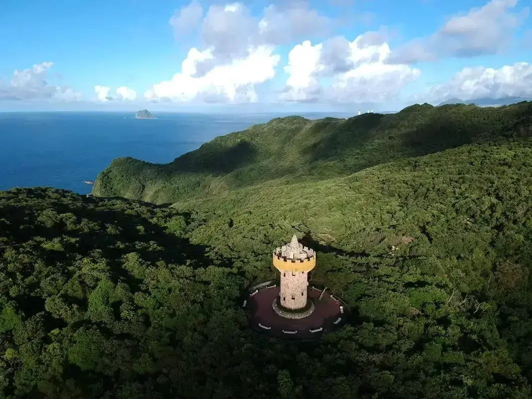
Lover's Tower, which is about a ten hike through the woods from Lover's Lake. It is one of the best spots to enjoy the scenery on Taiwan's Northern Coast. It is definitely a must-visit on your next trip to Keelung.
This blog is about the Lover's Tower in Keelung. For more information about Lover's Tower at Tamsui Fisherman's Wharf, click here. Background: The name "Lovers Lake" comes from the fact that there are actually two lakes, one larger and one smaller, so they are like a couple in love. The sandstone that forms the area was created between 10 and 20 million years ago and was pushed out of the sea along with northern Taiwan thousands of years ago. In the past, the area was run by a private company, which went out of business. Recently the Keelung City government has taken over control and has installed a trail that circles the lake. There is also a suspension bridge, windmill, and stone tower overlooking the lake. Nearby you can hike to Dawulun Fort or Eagle Rock which provides great views of the north coast. Currently, the lake is popular with hikers and Instagrammers, as well as wedding photographers. On the weekends it can get quite busy and parking can be hard to find. Hours: 24/7 Price: Free Tours: You can book a tour to Lover's Tower on KKday here. Activities: Don't forget that there are many activities available along Taiwan's Northern Coast such as Yachting, Fishing, Surfing, SUP / Paddle Boarding, Diving, Snorkeling Kayaking, Canoeing, Water Biking, River Tracing / Canyoneering, Glamping, Motorcycling, Motorbike Tour, Shen'ao Rail Bike, Night Fishing, Instagram Tour, Metaverse VR experience, Seaside Picnic, and more on Tripadvisor here, Klook here, or KKday here. Hotels in Keelung: We recommend Just Live Inn-Keelung and Yung Feng Hotel, which are two great quality hotels for a reasonable price in Keelung's City Center. You can book Just Live Inn-Keelung on Booking.com here, Agoda here, Klook here, Hotels.com here, Trip.com here, or Kayak here. You can book Yung Feng Hotel on Booking.com here, Agoda here, Hotels.com here, Trip.com here, Klook here, or Kayak here, How to get there: By car/scooter: Take Provincial highway northwest out of Keelung, and take a right on Jijin First Road toward Keelung Chang Kung Hospital. The Lover's Lake parking lot is at the top of the hill before the road turns into one lane. There is limited parking, and you may have to park further away. The trail is not wheelchair or stroller friendly. However, there is always plenty of scooter parking. If you are looking for car rentals, you can also search Qeeq here, Klook here, or KKday here. You can also check out our car rental guide here. Looking for scooter rental in northern Taiwan? You can search on Klook here or KKday here to search for options. You can also check out our scooter rental guide here. By Bicycle: Cycling is the best way to enjoy Taiwan's landscapes if you have the time and energy. Looking for bicycle rentals in Taiwan? You can use Taiwan's many Youbike sharing stations, or search for rentals on KKday here, and search for tours on Klook here. You can also check out our Taiwan cycling guide here. You can also book a cycling tour on TripAdvisor here. For more information, check out our Taiwan transportation guide here. By Bus: Unfortunately, there are no buses that directly get there, so you will have to walk from Provincial Highway 2, or take a taxi. You can purchase a discount easy card to use on the MRT and buses from Klook here or KKday here. You can also book an MRT travel pass on Klook here. Map: Please see below: 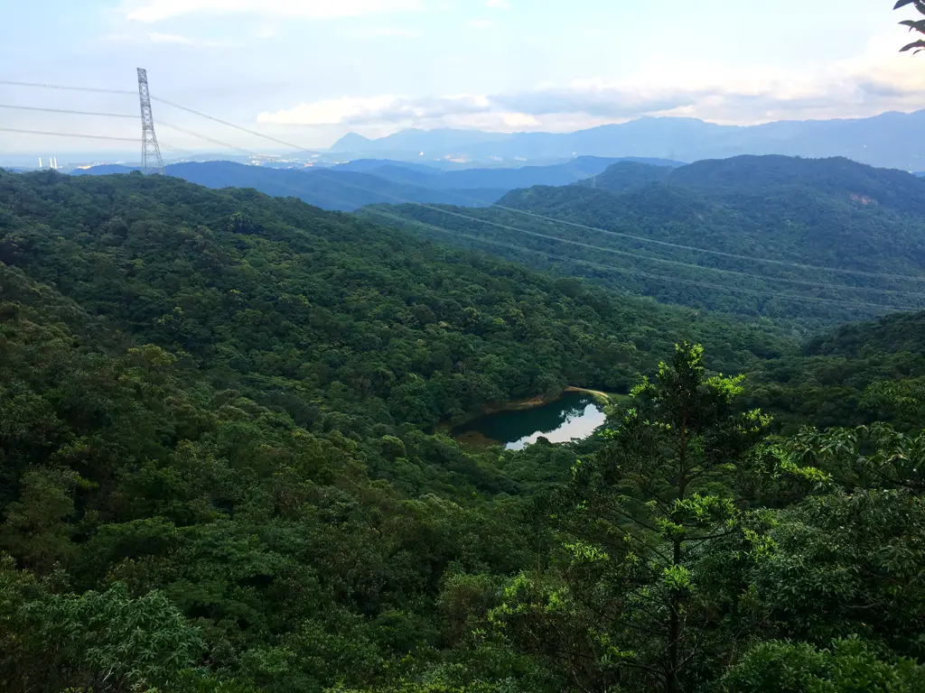
Xinshan Dream Lake (aka Xinshan Menghu) is a beautiful lake in Xizhi District of New Taipei. It is a popular place to stop for couples and Instagrammers due to its dream like aura. Also you can take the steep climb up Xinshan and enjoy some amazing views of east Taipei and Keelung. Besides taking photos, this Xinshan Dream Lake is a great place to relax and enjoy nature.
Background: The rock formations that form the Xinshan Dream lake hike formed as sediment under the ocean millions of years ago, and was later uplifted thanks to the collision of the Eurasian and Phillipine plates. The rocks are mainly sedimentary and are part of the same formation that forms the special rock formations on the northern coast around Keelung, and the waterfalls in Pingxi. Xinshan sits at 499 meters above sea level, while dream lake is 325 meters above sea level, which means the hike gains 175 meters from dream lake (in less than .5 KM), making it a short, steep hike. Dream Lake get's its name from the thick fog that covers it during winter months, making it look like a dreamscape. Dream Lake is a popular spot for couples, wedding photography, and Instagram photos. Hours: 24/7 Price: Free Hike Difficulty: Moderate: About an hour hike round trip, steep and difficult climbing through the forest with aid of ropes. Tours in Taipei: There are many tour itineraries that you can enjoy in Taipei that will take you to multiple destinations and arrange transportation. For more information, you can check out Tripadvisor here, KKday here or Klook here, which are both great tour websites that can connect you with the right tour and tour guide for you. Activities in Taipei: You can also look for more activities in Taipei such as Rock Climbing, Surfing, Speedboat Surfing, Diving, Snorkeling, Cooking Class, Glamping, Motorcycling, and more on Klook here or KKday here. Hotels in Taipei: We have stayed at and recommend the Yuanshan Grand Hotel, once the tallest building in Taiwan and still the most grand (book on Booking.com here, Tripadvisor here, or Agoda here). We have stayed at and also recommend Fu Chang Hotel in Ximending, which is within walking distance of Ximending shopping district (book on Booking.com here, Tripadvisor here, or Agoda here). Looking for a hotel? We recommend booking through Booking.com here, which provides the best quality selection of accommodation in Taiwan. Find out where to stay in our Taiwan hotels guide or search for the best hotel deals in Taiwan here. How to get there: By Car/Scooter: Take Xiwan Road (夕萬路) from Xizhi until you come to the turnoff the Xinshan Menghu on the right. It is a small one lane road up the mountain. There is scooter parking and limited car parking on the side of the road. You may need to park further down and hike up if you drive a car. The Lake trail is at the end of the road. Looking for scooter rental in Taipei? You can search on Klook here or KKday here to search for options. You can also check out our scooter rental guide here. If you are looking for car rentals, you can also search Qeeq here, Klook here, or KKday here. You can also check out our car rental guide here. By Bus: Take Dongnan Bus F910 from Xizhi Park about 40 minutes up the mountain to Xiwan Raod Bridge No. 3. From there you have to hike up to Xinshan before you come down to dream lake. Or you can get off at Menghu Intersection, but it is a long walk up the road. You can purchase a discount easy card to use on the MRT from Klook here or KKday here. You can also book an MRT travel pass on Klook here. By Bicycle: Cycling is the best way to enjoy Taiwan's landscapes if you have the time and energy. Looking for bicycle rentals in Taiwan? You can use Taiwan's many Youbike sharing stations, or search for rentals on KKday here, and search for tours on Klook here. You can also check out our Taiwan cycling guide here. ​You can also book a Sunset Riverside Bike Ride and Historical Tour, 4 Hour Cycling in Taipei, Ultimate 8-Hour Cycling City Tour, or Taipei City Bike Tour with Night Market Experience on TripAdvisor here. For more information, check out our Taiwan transportation guide here. Map: Please see below: 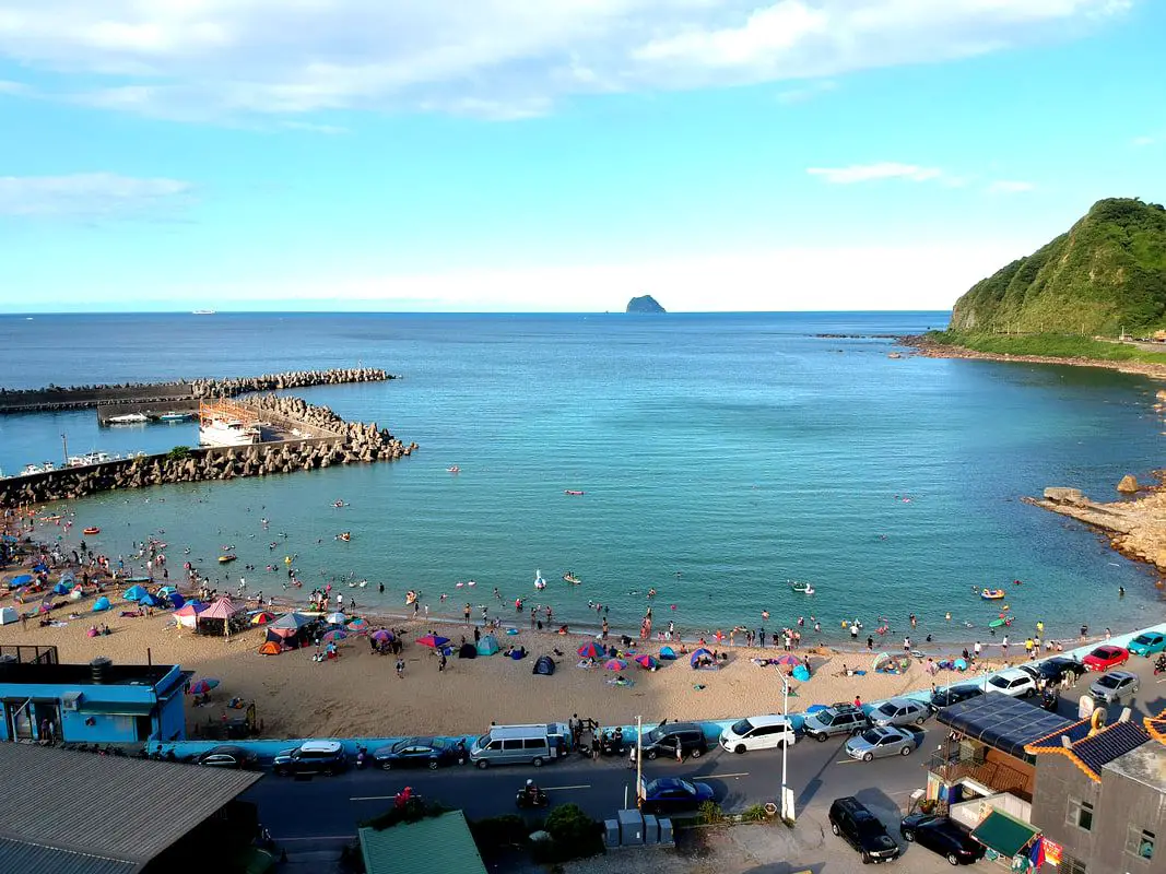
Only a 20 minute car drive away, Dawulun Beach in Keelung is the closest sandy ocean beach to Taipei City. Although it is small, it has a calm shallow swimming area and the sand looks like it was shipped straight from Kenting. It is definitely worth a visit for all beach lovers in Taipei.
Background: This beach is also known as Aodi Beach (澳底沙灘) or Waimushan Beach (外木山沙灘). In 2007, a road was created that connected Dawulun Beach with Wanli, creating a circular road around the north coast that was previously cut off. After that, more and more tourists started coming to this beach, especially from Taipei, because it is the closest oceanside destination to Taipei City. On weekends during the summer, the area can be totally packed with people. Hours: 24/7, but showers close after about 7 PM Price: Free Showers: Yes, multiple paid shower areas, about 30-50 NT per person Tours: You can book a tour to Taiwan's North Coast on TripAdvisor here, Klook here, or KKday here. Activities: Don't forget that there are many activities available along Taiwan's Northern Coast such as Wakeboarding, Surfing, Speedboat Surfing, SUP / Paddle Boarding, Diving, Snorkeling Kayaking, Canoeing, Water Biking, River Tracing / Canyoneering, ATVing, Horse Riding, Archery, Tree Climbing, Glamping, Motorcycling, Motorbike Tour, Dragon Boat Racing, Shen'ao Rail Bike, and more on Tripadvisor here, Klook here, or KKday here. Hotels in Keelung: We recommend Just Live Inn-Keelung and Yung Feng Hotel, which are two great quality hotels for a reasonable price in Keelung's City Center. You can book Just Live Inn-Keelung on Booking.com here, Agoda here, Klook here, Hotels.com here, Trip.com here, or Kayak here. You can book Yung Feng Hotel on Booking.com here, Agoda here, Hotels.com here, Trip.com here, Klook here, or Kayak here, How to get there: By Car/Scooter: From Keelung, take provincial highway 2 toward Wanli, and after you cross over the hill and see the ocean, turn right down to the beach. There is free parking on the side of the road, but good spots are limited. You can always park for free on the steep road that goes up the hill. If you are looking for car rentals, you can also search Qeeq here, Klook here, or KKday here. You can also check out our car rental guide here. Looking for scooter rental in northern Taiwan? You can search on Klook here or KKday here to search for options. You can also check out our scooter rental guide here. By Bicycle: Cycling is the best way to enjoy Taiwan's landscapes if you have the time and energy. Looking for bicycle rentals in Taiwan? You can use Taiwan's many Youbike sharing stations, or search for rentals on KKday here, and search for tours on Klook here. You can also check out our Taiwan cycling guide here. You can also book a cycling tour on TripAdvisor here. For more information, check out our Taiwan transportation guide here. By Bus: From Keelung Station, you can take the T99 tourist shuttle Binhai Qiji Line to the beach. The ride takes about 13 minutes. You can purchase a discount easy card to use on the MRT and buses from Klook here or KKday here. You can also book an MRT travel pass on Klook here. Map: Please see below: 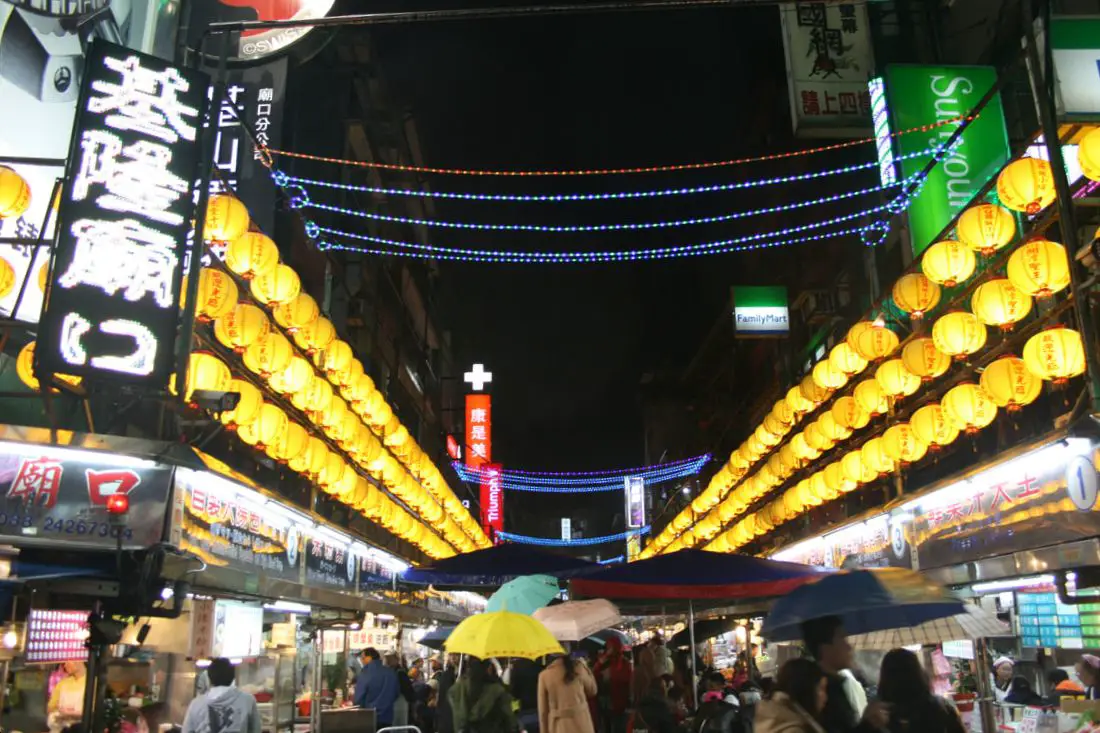
Keelung's Miaokou Night Market is a large night market in northern Taiwan, full of all kinds of delicious Taiwanese street food considered by some to be the best in Taiwan. The market consists mostly of food stalls in front of the Dianji Temple in Keelung, stretching on both sides down the street. It is said to be a must-see night market and one of the busiest in Taiwan.
Background: The Miaokou Night Market started up after completion of the Dianji Temple (奠基宮) during the Qing Dynasty in 1873. At the time the temple was surrounded by rice fields, but by the Japanese Era the area around the temple began to be developed. Food stalls really started to spread out at the entrance of the temple at the end of the Japanese Era. Since then, the famed food at Miaokou has brought more and more tourists to the area seeking delicious snacks. In recent years (since 2017), many stalls at the night market have become vacant due to high rents, and there have been notably less people visiting the night market. Some say that this is because of the advent of online shopping and food delivery apps. However another big factor is overpriced properties and stingy landlords. The night market is not going to close down anytime soon, but Taiwan is going through an economic transition period that is not only affecting the rental market but also consumer trends. Despite this, you will still be able to find delicious food on the street any night of the year. Hours: Every day 12:00 noon to 12:00 midnight. Price: Free admission. Tours: You can book a tour to Miaokou Night Market on Klook here or KKday here. Activities: Don't forget that there are many activities available along Taiwan's Northern Coast such as Wakeboarding, Surfing, Speedboat Surfing, SUP / Paddle Boarding, Diving, Snorkeling Kayaking, Canoeing, Water Biking, River Tracing / Canyoneering, ATVing, Horse Riding, Archery, Tree Climbing, Glamping, Motorcycling, Motorbike Tour, Dragon Boat Racing, Shen'ao Rail Bike, and more on Tripadvisor here, Klook here, or KKday here. Hotels in Keelung: We recommend Just Live Inn-Keelung and Yung Feng Hotel, which are two great quality hotels for a reasonable price in Keelung's City Center. You can book Just Live Inn-Keelung on Booking.com here, Agoda here, Klook here, Hotels.com here, Trip.com here, or Kayak here. You can book Yung Feng Hotel on Booking.com here, Agoda here, Hotels.com here, Trip.com here, Klook here, or Kayak here. How to get there: By Train: Take the TRA to Keelung Station, then walk east on Zhongyi Road (忠一路) until you reach the night market. Book tickets via the normal train (TRA) on Klook here. By Bus: Taking Keelung Bus (intercity bus) or K-Bus from Taipei Main Station or City Hall to Keelung. You can purchase a discount easy card to use on the MRT and buses from Klook here or KKday here. You can also book an MRT travel pass on Klook here. By Car: Take National Highway 1 north to the end of the highway until it becomes central Keelung, then turn right. There is plenty of parking to the south of the night market underground. If you are looking for car rentals, you can also search Qeeq here, Klook here, or KKday here. You can also check out our car rental guide here. By Scooter: Take provincial highway 5 to central Keelung. There is parking along the street but you might have to walk a ways to be able to park in a legal spot. Looking for scooter rental in northern Taiwan? You can search on Klook here or KKday here to search for options. You can also check out our scooter rental guide here. By Bicycle: Cycling is the best way to enjoy Taiwan's landscapes if you have the time and energy. Looking for bicycle rentals in Taiwan? You can use Taiwan's many Youbike sharing stations, or search for rentals on KKday here, and search for tours on Klook here. You can also check out our Taiwan cycling guide here. You can also book a cycling tour on TripAdvisor here. For more information, check out our Taiwan transportation guide here. Map: Please see below: 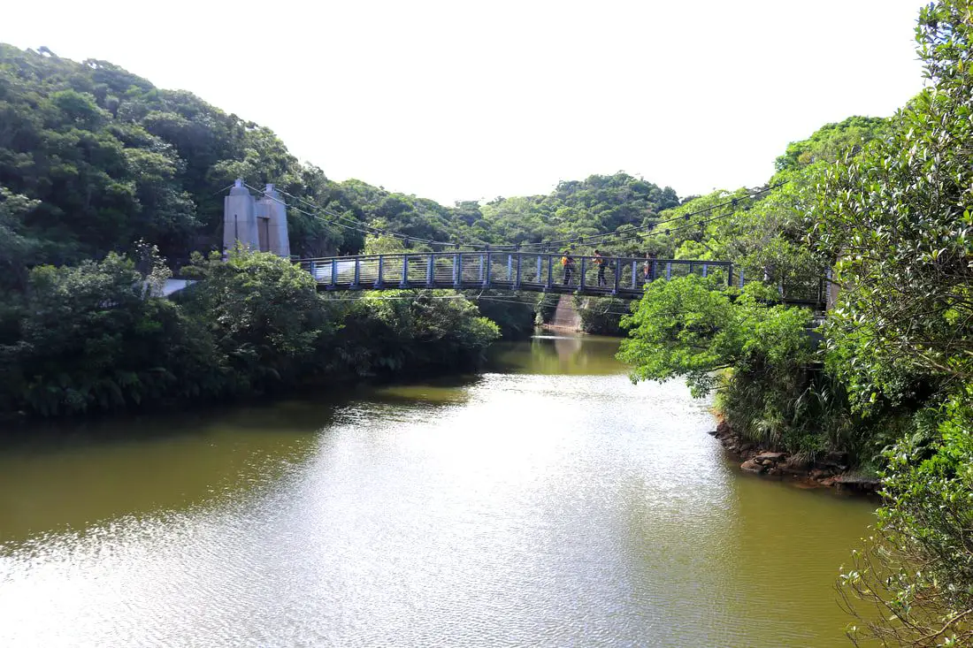
Lovers Lake is a small lake a recreation area in Anle District of Keelung City. It has some easy trails, bridges, and a tower that looks over the area. The lake trails also connect to Dawulun Fort. Overall it is a nice scenic spot for a day trip in Northern Taiwan.
Background: The name "Lovers Lake" comes from the fact that there are actually two lakes, one larger and one smaller, so they are a like a couple in love. The sandstone that forms the area was created between 10 and 20 million years ago, and was pushed out of the sea along with northern Taiwan thousands of years ago. In the past the area was run by a private company, which went out of business. Recently the Keelung City government has taken over control, and has installed a trail that circles the lake. There is also a suspension bridge, windmill, and stone tower overlooking the lake. Nearby you can hike to Dawulun Fort or Eagle Rock that provide great views of the north coast. Currently the lake is popular with hikers and intagrammers, as well as wedding photographers. On the weekends it can get quite busy and parking can be hard to find. Hours: 24/7 Price: Free Tours: You can book a hiking tour of Lover's Lake on KKday here. Activities: Don't forget that there are many activities available along Taiwan's Northern Coast such as Yachting, Fishing, Surfing, SUP / Paddle Boarding, Diving, Snorkeling Kayaking, Canoeing, Water Biking, River Tracing / Canyoneering, Glamping, Motorcycling, Motorbike Tour, Shen'ao Rail Bike, Night Fishing, Instagram Tour, Metaverse VR experience, Seaside Picnic, and more on Tripadvisor here, Klook here, or KKday here. Hotels in Keelung: We recommend Just Live Inn-Keelung and Yung Feng Hotel, which are two great quality hotels for a reasonable price in Keelung's City Center. You can book Just Live Inn-Keelung on Booking.com here, Agoda here, Klook here, Hotels.com here, Trip.com here, or Kayak here. You can book Yung Feng Hotel on Booking.com here, Agoda here, Hotels.com here, Trip.com here, Klook here, or Kayak here, How to get there: By car/scooter: Take provincial highway northwest out of Keelung, and take a right on Jijin First Road toward Keelung Chang Kung Hospital. The Lover's lake parking lot is at the top of the hill before the road turns into one lane. There is limited parking, and you may have to park further away. The trail is not wheelchair or stroller friendly. However there is always plenty of scooter parking. If you are looking for car rentals, you can also search Qeeq here, Klook here, or KKday here. You can also check out our car rental guide here. Looking for scooter rental in northern Taiwan? You can search on Klook here or KKday here to search for options. You can also check out our scooter rental guide here. By Bicycle: Cycling is the best way to enjoy Taiwan's landscapes if you have the time and energy. Looking for bicycle rentals in Taiwan? You can use Taiwan's many Youbike sharing stations, or search for rentals on KKday here, and search for tours on Klook here. You can also check out our Taiwan cycling guide here. You can also book a cycling tour on TripAdvisor here. For more information, check out our Taiwan transportation guide here. By Bus: Unfortunately there are no buses that directly get there, so you will have to walk from provincial highway 2, or take a taxi. You can purchase a discount easy card to use on the MRT and buses from Klook here or KKday here. You can also book an MRT travel pass on Klook here. Map: Please see below: 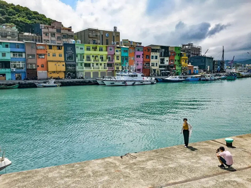
Zhengbin Harbor is a fishing harbor in Keelung that has recently become well-known for its colorfully painted houses. Recently it has become an Instagram selfie spot. There are also many interesting historical sights in the area for you to explore...(read more)
Brief Historical Background of Keelung: Keelung was formed as sediment under the ocean millions of years ago and were then uplifted thanks to the collision of the Eurasian and Phillipine plates. The rocks have then been slowly eroded away by wind and water, creating odd shapes that you see today. You can see similar formations at Yehliu Geopark. What is now Keelung was once part of Basay aborigine lands. Keelung was first settled by the Spanish in 1626, as their first settlement in what became their rule of northern Taiwan until they were defeated by the Dutch and left Taiwan in 1642. On Heping Island they built Fort San Salvador (聖薩爾瓦多城), which was destroyed and abandoned by the Dutch in 1668. The ruins of the fort were not confirmed to be found on the island until excavations in 2019. After the Japanese occupation of Taiwan, the island was renamed Sheliao Island (社寮島). After WWII, as part of the White Terror Movement, on March 8th, 1947 KMT soldiers kidnapped and shot some of about 30 civilians on the island that were suspected enemy conspirators, known as the Sheliao Incident "社寮事件." After this, the people on the island decided to change to island's name to "Peace Island" or Heping Island in Chinese, so that the KMT would stop harassing the local people and bring peace to the island. Keelung is now a popular daytime and weekend destination for many Taiwanese. Tours: You can book a walking tour to Zhengbin Harbor and Heping Island on Klook here or KKday here. Attractions around Keelung: There are many attractions that you can enjoy in Keelung such as Heping Island Park, Miaokou Night Market, Chaojing Smart Aquarium, Kanziding Fish Market, National Museum of Marine Science and Biology, Yehliu Ocean World, Yehliu Geopark, Jiufen, Elephant Trunk Rock, Ju Ming Museum, New Taipei Gold Museum, Bat Cave, Candlestick Islet, and many more attractions on Tripadvisor here, Klook here, or KKday here. Activities in Keelung: Yachting, Fishing, Surfing, SUP / Paddle Boarding, Diving, Snorkeling Kayaking, Canoeing, Water Biking, River Tracing / Canyoneering, Glamping, Motorcycling, Motorbike Tour, Shen'ao Rail Bike, Night Fishing, Instagram Tour, Metaverse VR experience, Seaside Picnic, and more on Tripadvisor here, Klook here, or KKday here. Hotels in Keelung: We recommend Just Live Inn-Keelung and Yung Feng Hotel, which are two great quality hotels for a reasonable price in Keelung's City Center. You can book Just Live Inn-Keelung on Booking.com here, Agoda here, Klook here, Hotels.com here, Trip.com here, or Kayak here. You can book Yung Feng Hotel on Booking.com here, Agoda here, Hotels.com here, Trip.com here, Klook here, or Kayak here. How to get there: The best place to view Zhengbin Harbor is from Heping Island. By Car/Scooter: Take provincial highway 2 north out of Keelung and take a left at Zhengbin Road. Cross the bridge over to the island and head to the park which is on the north side of the island. There is paid parking in front of the park. If you are looking for car rentals, you can also search Qeeq here, Klook here, or KKday here. You can also check out our car rental guide here. Looking for scooter rental in northern Taiwan? You can search on Klook here or KKday here to search for options. You can also check out our scooter rental guide here. By Bus: From Keelung, take Keeling Bus 101 to Heping Island bus stop. You can purchase a discount easy card to use on the MRT and buses from Klook here or KKday here. You can also book an MRT travel pass on Klook here. By Bicycle: Cycling is the best way to enjoy Taiwan's landscapes if you have the time and energy. Looking for bicycle rentals in Taiwan? You can use Taiwan's many Youbike sharing stations, or search for rentals on KKday here, and search for tours on Klook here. You can also check out our Taiwan cycling guide here. You can also book a cycling tour on TripAdvisor here. For more information, check out our Taiwan transportation guide here. Map: 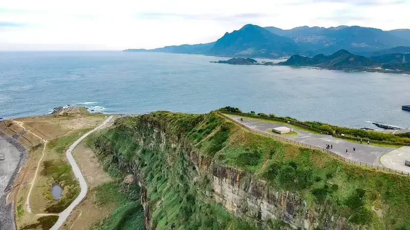
Chaojing Park is a rocky area along Taiwan's north coast in Keelung. It includes a seafood market, marine science museum, and a wide grassy area. There are also many interesting rock formations in the area. It is a popular location for its seafood, flying kites, hiking, and enjoying the ocean scenery
Background: The sandstone and sedimentary that forms the Badouzi formations were created between 10 and 20 million years ago, and was pushed out of the sea along with northern Taiwan thousands of years ago. The rock formations formed by easily eroding sandstone, by the sea and waves. The area around Chaojing Park was a protected military base and garbage dunmp, after which civilians were allowed to freely visit. Kite flying is also a popular activity at the park. Hours: 24/7 Price: Free Chaojing Aquarium: 300 NT You can book tickets to Chaojing Smart Aquarium for a discount on KKday here. Tours: You can book a tour to Taiwan's North Coast on TripAdvisor here, Klook here, or KKday here. Hotels in Keelung: We recommend Just Live Inn-Keelung and Yung Feng Hotel, which are two great quality hotels for a reasonable price in Keelung's City Center. You can book Just Live Inn-Keelung on Booking.com here, Agoda here, Klook here, Hotels.com here, Trip.com here, or Kayak here. You can book Yung Feng Hotel on Booking.com here, Agoda here, Hotels.com here, Trip.com here, Klook here, or Kayak here. How to get there: By Car/Scooter: Drive to Keelung, then from downtown take provincial highway 2 east about 10 KM until you reach the the turnoff to Chaojing Park, and there is some paid parking if you drive to the very end, which will put you closest to the park. There is paid parking in front of the park. If you are looking for car rentals, you can also search Qeeq here, Klook here, or KKday here. You can also check out our car rental guide here. Looking for scooter rental in northern Taiwan? You can search on Klook here or KKday here to search for options. You can also check out our scooter rental guide here. By Train/Bus: Take the TRA to Badouzi (八斗子) station, then walk about 1 KM northwest until you reach the Chaojing Park. You can purchase a discount easy card to use on the MRT and buses from Klook here or KKday here. You can also book an MRT travel pass on Klook here. By Bicycle: Cycling is the best way to enjoy Taiwan's landscapes if you have the time and energy. Looking for bicycle rentals in Taiwan? You can use Taiwan's many Youbike sharing stations, or search for rentals on KKday here, and search for tours on Klook here. You can also check out our Taiwan cycling guide here. You can also book a cycling tour on TripAdvisor here. For more information, check out our Taiwan transportation guide here. Map: Please see below: 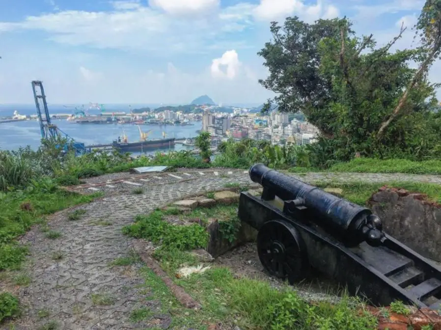
Ershawan Fort (aka Ershawan battery or Tenable Gate of the Sea 海門天險), is a Qing Dynasty era fort that once guarded Keelung Harbor among a network of other forts. For a brief time was taken over by the French during the Sino-French War. Now it stands as a wonderfully preserved monument to the past, with great views of Keelung Harbor.
Background: Ershawan Fort started as a seaside fortification in 1840 as a response to the First Opium War. During the war, a British ship called the Nerbudda fired on the fort, destroying one of the soldier dorm rooms. The ship later bottomed out on a coral reef and the sailors were imprisoned. In August of 1884, 5 French ships under direction of general S. N. J. Lespes attacked the forts at Keelung, attacking from the side. Because the cannons in Ershawan Fort could not rotate, they were useless against the ships. Most of the canons and gunpowder were destroyed or exploded. The next day the French Forces invaded Keelung with a force of about 500 men. They made a cemetery nearby for their men, which was later moved to Ershawan Fort were it still remains to this day. After the war, in an effort to protect the coal reserves near Keelung from the French, the then Imperial Inspector on Military Affairs Liu Mingchuan decided to improve fortifications in Keelung by relocating the Ershawan fortress to the nearby hillside. The new fortress was built in western style with the help of German technicians. The new fortress was completed in 1888 and included two 6 inch Armstrong guns and one 8 inch Armstrong gun. Liu Mingchuan also installed new revolving bases for the cannons, and created a camp below with the "Tenable Gate of the Sea." After the Japanese took Taiwan, the fort was barely used and fell into decay. The fort was declared a national historic monument in 1997. The fort and pathways were further restored in 2018. Now it is a popular attraction in the area especially because of the great view of Keelung Harbor that can be seen from the fort. Hours: 24/7 Price: Free Tours: You can book a tour to Taiwan's North Coast on TripAdvisor here, Klook here, or KKday here. Activities: Don't forget that there are many activities available along Taiwan's Northern Coast such as Yachting, Fishing, Surfing, SUP / Paddle Boarding, Diving, Snorkeling Kayaking, Canoeing, Water Biking, River Tracing / Canyoneering, Glamping, Motorcycling, Motorbike Tour, Shen'ao Rail Bike, Night Fishing, Instagram Tour, Metaverse VR experience, Seaside Picnic, and more on Tripadvisor here, Klook here, or KKday here. Hotels in Keelung: We recommend Just Live Inn-Keelung and Yung Feng Hotel, which are two great quality hotels for a reasonable price in Keelung's City Center. You can book Just Live Inn-Keelung on Booking.com here, Agoda here, Klook here, Hotels.com here, Trip.com here, or Kayak here. You can book Yung Feng Hotel on Booking.com here, Agoda here, Hotels.com here, Trip.com here, Klook here, or Kayak here. How to get there: By Car/Scooter: From central Keelung, take Shoushan Road up the hill on the east part of the city and the fort is at the very top of the hill. There is limited free parking near the top. If you are looking for car rentals, you can also search Qeeq here, Klook here, or KKday here. You can also check out our car rental guide here. Looking for scooter rental in northern Taiwan? You can search on Klook here or KKday here to search for options. You can also check out our scooter rental guide here. By Bicycle: Cycling is the best way to enjoy Taiwan's landscapes if you have the time and energy. Looking for bicycle rentals in Taiwan? You can use Taiwan's many Youbike sharing stations, or search for rentals on KKday here, and search for tours on Klook here. You can also check out our Taiwan cycling guide here. You can also book a cycling tour on TripAdvisor here. For more information, check out our Taiwan transportation guide here. By Bus: There is no direct way to get there by bus, but you can take the 204 bus from Keelung Station to Keeling Stadium station and then walk up the hill about 1 KM to the fort. I think you can reach the fort from the harbor side, but I'm not sure where the entrance to the trail is. You can purchase a discount easy card to use on the MRT and buses from Klook here or KKday here. You can also book an MRT travel pass on Klook here. Map: Please see below: 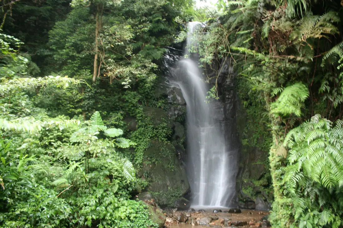
Tai'an Waterfall is a tall waterfall in Qidu District in Keelung City, Taiwan. It is easily accessible via a flat hiking path that takes about 10 minutes to complete, and includes amazing natural scenery. It's spectacular cascading falls are definitely worth a stop for anyone in Taiwan.
Background: Tai'an Waterfall is roughly 20 meters high and 2 meters wide (64 x 13 ft.). It is located on Cayan Mountain in Qidu. The rock formations that form the Waterfall formed as sediment under the ocean millions of years ago and were then uplifted thanks to the collision of the Eurasian and Phillipine plates. The rocks are mainly sedimentary and are part of the same formation that forms the special rock formations on the northern coast around Keelung. The area also has some coal deposits, and there is an abandoned mine on the trail. The rocks here easily erode, making for odd shapes in the riverbed. Hours: 24/7 Price: Free When to go: Go in the spring time when there is more rain. If you go during the dry season, the waterfall will be quite small. Difficulty: Easy Activities: Don't forget that there are many activities available in northern Taiwan such as Wakeboarding, Surfing, Speedboat Surfing, SUP / Paddle Boarding, Diving, Snorkeling Kayaking, Canoeing, Water Biking, River Tracing / Canyoneering, ATVing, Horse Riding, Archery, Tree Climbing, Glamping, Motorcycling, Motorbike Tour, Dragon Boat Racing, Shen'ao Rail Bike, and more on Tripadvisor here, Klook here, or KKday here. Hotels in Keelung: We recommend Just Live Inn-Keelung and Yung Feng Hotel, which are two great quality hotels for a reasonable price in Keelung's City Center. You can book Just Live Inn-Keelung on Booking.com here, Agoda here, Klook here, Hotels.com here, Trip.com here, or Kayak here. You can book Yung Feng Hotel on Booking.com here, Agoda here, Hotels.com here, Trip.com here, Klook here, or Kayak here. How to get there: By Train: Take the TRA to Ruifang Station, and then switch to the Pingxi Railway line. Get off at Shifen Station, then walk along the main road south until you reach the Shifen Waterfall trail. It will be hard to miss; there are signs along the way. You can purchase a discount easy card to use on the MRT and buses from Klook here or KKday here. You can also book an MRT travel pass on Klook here. By Car/Scooter: Take provincial highway 2 east toward Pinglin, then get off the main highway once you reach Shifen. The waterfall is to the left of the main bridge across the valley, and parking is plentiful. Scooter parking is free at the entrance. If you are looking for car rentals, you can also search Qeeq here, Klook here, or KKday here. You can also check out our car rental guide here. Looking for scooter rental in northern Taiwan? You can search on Klook here or KKday here to search for options. You can also check out our scooter rental guide here. By Bicycle: Cycling is the best way to enjoy Taiwan's landscapes if you have the time and energy. Looking for bicycle rentals in Taiwan? You can use Taiwan's many Youbike sharing stations, or search for rentals on KKday here, and search for tours on Klook here. You can also check out our Taiwan cycling guide here. You can also book a cycling tour on TripAdvisor here. For more information, check out our Taiwan transportation guide here. Map: Please see below 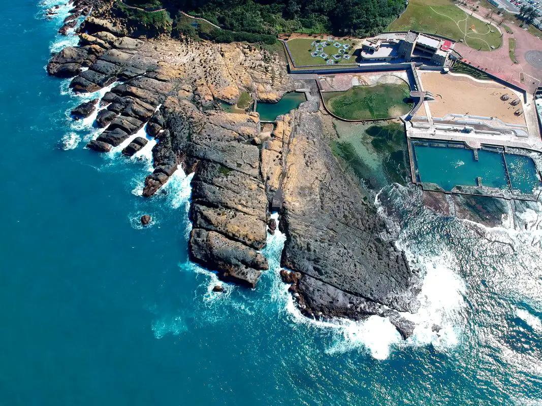
Heping Island Park is a geo-park and water park on Heping Island, just outside of downtown Keelung. Here you can find many interesting sedimentary rock formations along the seashore. There are also salt water swimming pools, amazing places to go diving, a playground, hiking trails, and historical sights. Some would say this island is the world's best kept secret. It is definitely worth stopping here along Taiwan's northern coast.
Historical Background: Heping Island was formed as sediment under the ocean millions of years ago and were then uplifted thanks to the collision of the Eurasian and Philippine plates. The rocks have then been slowly eroded away by wind and water, creating odd shapes that you see today. You can see similar formations atYehliu Geopark. Heping island is the closest island to the main island of Taiwan. It first part of Basay aborigine lands. Chinese fisherman first called the island Greater Keelung Island. The island was first settled by the Spanish in 1626, as their first settlement in what became their rule of northern Taiwan until they were defeated by the Dutch and left Taiwan in 1642. On Heping Island they built Fort San Salvador (聖薩爾瓦多城), which was destroyed and abandoned by the Dutch in 1668. The ruins of the fort were not confirmed to be found on the island until excavations in 2019. After the Japanese occupation of Taiwan, the island was renamed Sheliao Island (社寮島). After WWII, as part of the White Terror Movement, on March 8th, 1947 KMT soldiers kidnapped and shot some of about 30 civilians on the island that were suspected enemy conspirators, known as the Sheliao Incident "社寮事件." After this, the people on the island decided to change to island's name to "Peace Island" or Heping Island in Chinese, so that the KMT would stop harassing the local people and bring peace to the island. The Island was under KMT military control until the 1970s, after which tourists were allowed to enter the island. Now it is a popular daytime and weekend destination for many Taiwanese. Hours: 8 AM to 6 PM Price: 80 NT per person You can buy a discount entrance ticket to Heping Island Park on Klook here or KKday here. Tours: You can also book a tour to Heping Island on TripAdvisor here, Klook here, or KKday here. When to go: During the summer (May to November) when the water is warm and calm for swimming and diving. Activities: Don't forget that there are many activities available along Taiwan's Northern Coast such as Wakeboarding, Surfing, Speedboat Surfing, SUP / Paddle Boarding, Diving, Snorkeling Kayaking, Canoeing, Water Biking, River Tracing / Canyoneering, ATVing, Horse Riding, Archery, Tree Climbing, Glamping, Motorcycling, Motorbike Tour, Dragon Boat Racing, Shen'ao Rail Bike, and more on Tripadvisor here, Klook here, or KKday here. Hotels in Keelung: We recommend Just Live Inn-Keelung and Yung Feng Hotel, which are two great quality hotels for a reasonable price in Keelung's City Center. You can book Just Live Inn-Keelung on Booking.com here, Agoda here, Klook here, Hotels.com here, Trip.com here, or Kayak here. You can book Yung Feng Hotel on Booking.com here, Agoda here, Hotels.com here, Trip.com here, Klook here, or Kayak here. How to get there: By Car/Scooter: Take provincial highway 2 north out of Keelung and take a left at Zhengbin Road. Cross the bridge over to the island and head to the park which is on the north side of the island. There is paid parking in front of the park. There is paid parking in front of the park. If you are looking for car rentals, you can also search Qeeq here, Klook here, or KKday here. You can also check out our car rental guide here. Looking for scooter rental in northern Taiwan? You can search on Klook here or KKday here to search for options. You can also check out our scooter rental guide here. By Bus: From Keelung, take Keeling Bus 101 to Heping Island bus stop. You can purchase a discount easy card to use on the MRT and buses from Klook here or KKday here. You can also book an MRT travel pass on Klook here. By Bicycle: Cycling is the best way to enjoy Taiwan's landscapes if you have the time and energy. Looking for bicycle rentals in Taiwan? You can use Taiwan's many Youbike sharing stations, or search for rentals on KKday here, and search for tours on Klook here. You can also check out our Taiwan cycling guide here. You can also book a cycling tour on TripAdvisor here. For more information, check out our Taiwan transportation guide here. Map: Please see below: 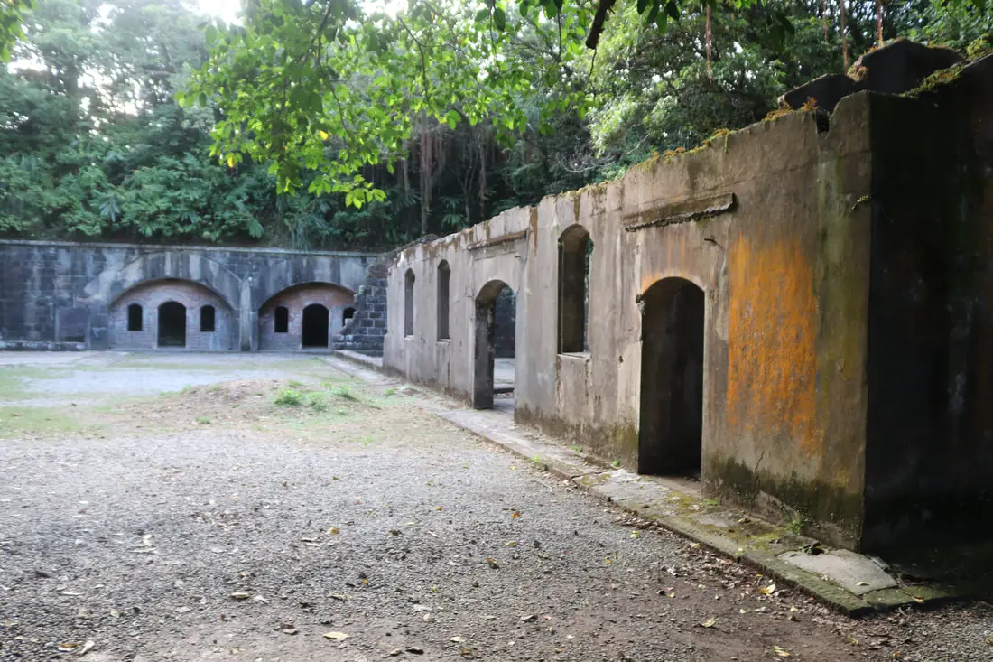
Dawulun Fort is a Qing Dynasty era fort that once guarded the coast along Wanli, Jinshan, and Keelung, among a network of other forts. Now it stands as a wonderfully preserved monument to the past, with great views of Keelung Harbor and Wanli District.
Background: Dawulun Fort started as a seaside fortification in 1875 in order to protect Dawulun Harbor, Keelung Harbor, and the road from Tamsui to Keelung which goes through Jinshan. Soldiers began being stationed on the hill at Dawulun as early as 1840. The fort was an important piece of defense during the Opium Wars and the Sino-French War. A total of 10 Canons were placed at the fort at one time. After the Japanese took Taiwan, the fort was not used after 1935 and fell into decay. When the ROC took Taiwan, they took down all the remaining canons. The fort was declared a national historic monument in 1985. Since the early 2000's some people have illegally dug around the site looking for buried treasure, even though a study in 2003 found that there was no treasure buried in this site. Now it is a popular attraction in the area especially because of the great view of Keelung and Wanli that can be seen from the fort. Hours: 24/7 Price: Free Tours: You can book a tour to Dawulun Fort on KKday here. Activities: Don't forget that there are many activities available along Taiwan's Northern Coast such as Yachting, Fishing, Surfing, SUP / Paddle Boarding, Diving, Snorkeling Kayaking, Canoeing, Water Biking, River Tracing / Canyoneering, Glamping, Motorcycling, Motorbike Tour, Shen'ao Rail Bike, Night Fishing, Instagram Tour, Metaverse VR experience, Seaside Picnic, and more on Tripadvisor here, Klook here, or KKday here. Hotels on Taiwan's Northern Coast: We recommend Fullon Hotel which has locations in Tamsui and Fulong near the beach (book on Booking.com here, Tripadvisor here, Agoda here, or Hotels.com here). We have also stayed at and recommend Hai Xia Your Home which is right in front of Fulong Beach (book on Booking.com here, Tripadvisor here, Agoda here, or Hotels.com here). Looking for a hotel? We recommend booking through Booking.com here, which provides the best quality selection of accommodation in Taiwan. Find out where to stay in our Taiwan hotels guide or search for the best hotel deals in Taiwan here. How to get there: By car/scooter: Take provincial highway northwest out of Keelung, and take a right on Jijin First Road toward Keelung Chang Kung Hospital. The Dawulun Fort parking lot is at the top of the hill after the road turns into one lane. There is lots of parking. The trail is not wheelchair or stroller friendly. If you are looking for car rentals, you can also search Qeeq here, Klook here, or KKday here. You can also check out our car rental guide here. Looking for scooter rental in northern Taiwan? You can search on Klook here or KKday here to search for options. You can also check out our scooter rental guide here. By Bicycle: Cycling is the best way to enjoy Taiwan's landscapes if you have the time and energy. Looking for bicycle rentals in Taiwan? You can use Taiwan's many Youbike sharing stations, or search for rentals on KKday here, and search for tours on Klook here. You can also check out our Taiwan cycling guide here. You can also book a cycling tour on TripAdvisor here. For more information, check out our Taiwan transportation guide here. By Bus: Unfortunately there are no buses that directly get there, so you will have to walk from provincial highway 2, or take a taxi. You can purchase a discount easy card to use on the MRT and buses from Klook here or KKday here. You can also book an MRT travel pass on Klook here. Map: Please see below: 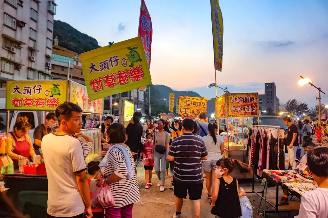
Badouzi Weekend Night Market is a popular night market on the coast of Keelung near Baodouzi Harbor. Even though it is only open on weekends, you will find almost every Taiwanese night market snack you could want here. You probably won't see any other tourists or foreigners. Popular foods here include fried squid, steak, onion pancakes, papaya milk, and more.
Background: Badouzi Weekend Night Market was established in 2002, formed on an empty lot owned by the Haibawang restaurant chain. Originally the night market had 50 stalls, and now in 2023 you can find about 200 night market stalls here. Popular foods here include fried squid, steak, onion pancakes, Papaya milk, and other Taiwan night market favorites. Hours: Saturday and Sunday 5 PM to 12 midnight. Closed on rainy days. Price: Free Hotels in Keelung: We recommend Just Live Inn-Keelung and Yung Feng Hotel, which are two great quality hotels for a reasonable price in Keelung's City Center. You can book Just Live Inn-Keelung on Booking.com here, Agoda here, Klook here, Hotels.com here, Trip.com here, or Kayak here. You can book Yung Feng Hotel on Booking.com here, Agoda here, Hotels.com here, Trip.com here, Klook here, or Kayak here. Tours near Keelung: There are many tour itineraries that you can enjoy in Keelung that will take you to multiple destinations and arrange transportation. For more information, you can check out Tripadvisor here, KKday here or Klook here, which are both great tour websites that can connect you with the right tour and tour guide for you. Here are some of the most popular tours of Taipei on Tripadvisor:
There are many attractions that you can enjoy in Keelung such as Heping Island Park, Miaokou Night Market, Chaojing Smart Aquarium, Kanziding Fish Market, National Museum of Marine Science and Biology, Yehliu Ocean World, Yehliu Geopark, Jiufen, Elephant Trunk Rock, Ju Ming Museum, New Taipei Gold Museum, Bat Cave, Candlestick Islet, and many more attractions on Tripadvisor here, Klook here, or KKday here. Activities in Keelung: Yachting, Fishing, Surfing, SUP / Paddle Boarding, Diving, Snorkeling Kayaking, Canoeing, Water Biking, River Tracing / Canyoneering, Glamping, Motorcycling, Motorbike Tour, Shen'ao Rail Bike, Night Fishing, Instagram Tour, Metaverse VR experience, Seaside Picnic, and more on Tripadvisor here, Klook here, or KKday here. Just to let you know, if you book using the links above, we get some commission at no cost to you, and you can help support our blog. Some of the Klook links may not work if you are using an Ad blocker. You can click here to receive $5 USD on your first Klook purchase. How to get there: By Car/Scooter: Drive to Keelung, then from downtown take provincial highway 2 east about 10 KM until you reach the the Badouzi Harbor, and there is some paid parking at the harbor and limited free parking on the side of the road. Looking for scooter rental in Keelung? Search KKday here for options. You can also check out our scooter rental guide here. If you are looking for car rentals, you can also search Qeeq here, Klook here, or KKday here. You can also check out our car rental guide here. By Train/Bus: Take the TRA to Badouzi (八斗子) station, then walk about 1 KM south until you reach the night market. Book tickets via the normal train (TRA) on Klook here. By Bicycle: Cycling is the best way to enjoy Taiwan's landscapes if you have the time and energy. Looking for bicycle rentals in Taiwan? You can use Taiwan's many Youbike bike sharing stations, or search for rentals on KKday here, and search for tours on Klook here. You can also check out our Taiwan cycling guide here. For more information, check out our Taiwan transportation guide here. Map: 
The Keelung Marine Science Museum (國立海洋科技博物館) is a former power plant that has been converted into a museum and IMAX Theater. It also features many educational exhibits about Taiwan's sea life and marine science. It is definitely worth a stop during your next trip to Keelung.
Background: The sandstone and sedimentary that forms the Badouzi formations were created between 10 and 20 million years ago, and was pushed out of the sea along with northern Taiwan thousands of years ago. The rock formations formed by easily eroding sandstone, by the sea and waves. The area around Chaojing Park was a protected military base and garbage dunmp, after which civilians were allowed to freely visit. Kite flying is also a popular activity at the park. Hours: 24/7 Price: The price for admission is 200 NT. You can book tickets for a discount on Klook here or KKday here. Tours: You can also book a chartered tour to the museum and nearby sights on KKday here. Hotels in Keelung: We recommend Just Live Inn-Keelung and Yung Feng Hotel, which are two great quality hotels for a reasonable price in Keelung's City Center. You can book Just Live Inn-Keelung on Booking.com here, Agoda here, Klook here, Hotels.com here, Trip.com here, or Kayak here. You can book Yung Feng Hotel on Booking.com here, Agoda here, Hotels.com here, Trip.com here, Klook here, or Kayak here. How to get there: By Car/Scooter: Drive to Keelung, then from downtown take provincial highway 2 east about 10 KM until you reach the the turnoff to Chaojing Park, and there is some paid parking if you drive to the very end, which will put you closest to the park. If you are looking for car rentals, you can also search Qeeq here, Klook here, or KKday here. You can also check out our car rental guide here. Looking for scooter rental in northern Taiwan? You can search on Klook here or KKday here to search for options. You can also check out our scooter rental guide here. By Train/Bus: Take the TRA to Badouzi (八斗子) station, then walk about 1 KM northwest until you reach the Chaojing Park. You can purchase a discount easy card to use on the MRT and buses from Klook here or KKday here. You can also book an MRT travel pass on Klook here. By Bicycle: Cycling is the best way to enjoy Taiwan's landscapes if you have the time and energy. Looking for bicycle rentals in Taiwan? You can use Taiwan's many Youbike sharing stations, or search for rentals on KKday here, and search for tours on Klook here. You can also check out our Taiwan cycling guide here. You can also book a cycling tour on TripAdvisor here. For more information, check out our Taiwan transportation guide here. Map: 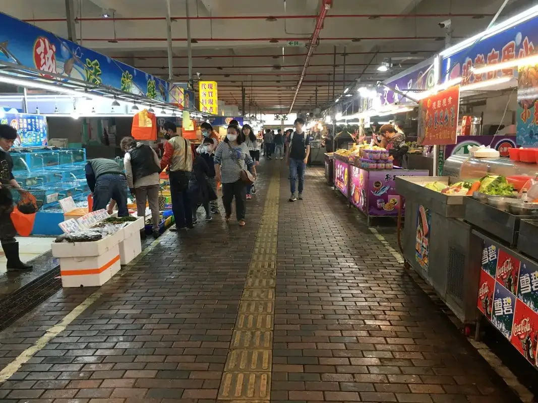
Badouzi Harbor is a busy fishing harbor with a popular seafood market in Keelung, and also has a few seafood restaurants inside. You can also take a ferry to Keelung Islet from here. It is definitely worth visiting on your next trip to Keelung.
Background: The sandstone and sedimentary that forms the Badouzi formations were created between 10 and 20 million years ago, and was pushed out of the sea along with northern Taiwan thousands of years ago. The rock formations formed by easily eroding sandstone, by the sea and waves. The area around Chaojing Park was a protected military base and garbage dump, after which civilians were allowed to freely visit. Kite flying is also a popular activity at the park. Hours: 24/7 Price: Free Tours: You can book a tour to Taiwan's North Coast on TripAdvisor here, Klook here, or KKday here. Activities: Don't forget that there are many activities available along Taiwan's Northern Coast such as Yachting, Fishing, Surfing, SUP / Paddle Boarding, Diving, Snorkeling Kayaking, Canoeing, Water Biking, River Tracing / Canyoneering, Glamping, Motorcycling, Motorbike Tour, Shen'ao Rail Bike, Night Fishing, Instagram Tour, Metaverse VR experience, Seaside Picnic, and more on Tripadvisor here, Klook here, or KKday here. Hotels in Keelung: We recommend Just Live Inn-Keelung and Yung Feng Hotel, which are two great quality hotels for a reasonable price in Keelung's City Center. You can book Just Live Inn-Keelung on Booking.com here, Agoda here, Klook here, Hotels.com here, Trip.com here, or Kayak here. You can book Yung Feng Hotel on Booking.com here, Agoda here, Hotels.com here, Trip.com here, Klook here, or Kayak here. How to get there: By Car/Scooter: Drive to Keelung, then from downtown take provincial highway 2 east about 10 KM until you reach the the turnoff to Chaojing Park, and there is some paid parking if you drive to the very end, which will put you closest to the park. If you are looking for car rentals, you can also search Qeeq here, Klook here, or KKday here. You can also check out our car rental guide here. Looking for scooter rental in northern Taiwan? You can search on Klook here or KKday here to search for options. You can also check out our scooter rental guide here. By Train/Bus: Take the TRA to Badouzi (八斗子) station, then walk about 1 KM northwest until you reach the Chaojing Park. You can purchase a discount easy card to use on the MRT and buses from Klook here or KKday here. You can also book an MRT travel pass on Klook here. Map: 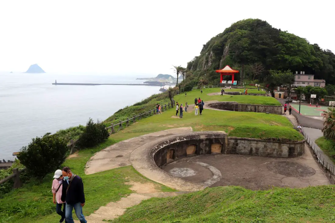
Baimiweng Fort is an abandoned fort in Keelung that is now open to the public, dating back to the Dutch colonization of Taiwan. Here you can learn more about Taiwan's colonial history, and enjoy amazing panoramic views of Keelung and the surrounding area. Keelung Lighthouse is also within walking distance.
Background: Baimiweng Fort is thought to have been built over the ruins of either Milaen Fort or Fort Clement, which were Dutch Forts built in the 1600s, seen on maps at the time. It was later used by the Qing forces, and was occupied briefly by French forces during the Sino-French war. The current fort that you see today was built during the Japanese era in Taiwan in 1900 to defend against Russia, in response to the Russio-Japanese War. It had some of the first artillery emplacements in Keelung and acted as a first line of defense. During the Japanese era, the fort was occupied and renovated in 1927 and expanded in 1931. After the ROC took control of Taiwan, the fort no longer stationed troops and was abandoned, and used as a public restroom for local residents. The fort then underwent restoration work in 1980, and a later restoration was completed in 2021 including hiking trails to connect with Keelung Lighthouse. Keelung Lighthouse was built during the Qing Dynasty in 1900 and refurbished in 1962. It is still an important lighthouse for ships in the area. The Fort is a popular location for tourists especially on weekends and holidays. Hours: 7 AM to 7 PM every day Price: Free Tours near Keelung: There are many tour itineraries that you can enjoy in Keelung that will take you to multiple destinations and arrange transportation. For more information, you can check out Tripadvisor here, KKday here or Klook here, which are both great tour websites that can connect you with the right tour and tour guide for you. Here are some of the post popular tours of Taipei on Tripadvisor:
Attractions around Keelung: There are many attractions that you can enjoy in Keelung such as Heping Island Park, Miaokou Night Market, Chaojing Smart Aquarium, Kanziding Fish Market, National Museum of Marine Science and Biology, Yehliu Ocean World, Yehliu Geopark, Jiufen, Elephant Trunk Rock, Ju Ming Museum, New Taipei Gold Museum, Bat Cave, Candlestick Islet, and many more attractions on Tripadvisor here, Klook here, or KKday here. Activities in Keelung: Yachting, Fishing, Surfing, SUP / Paddle Boarding, Diving, Snorkeling Kayaking, Canoeing, Water Biking, River Tracing / Canyoneering, Glamping, Motorcycling, Motorbike Tour, Shen'ao Rail Bike, Night Fishing, Instagram Tour, Metaverse VR experience, Seaside Picnic, and more on Tripadvisor here, Klook here, or KKday here. Just to let you know, if you book using the links above, we get some commission at no cost to you, and you can help support our blog. Some of the Klook links may not work if you are using an Ad blocker. You can click here to receive $5 USD on your first Klook purchase. Hotels in Keelung: We recommend Just Live Inn-Keelung and Yung Feng Hotel, which are two great quality hotels for a reasonable price in Keelung's City Center. You can book Just Live Inn-Keelung on Booking.com here, Agoda here, Klook here, Hotels.com here, Trip.com here, or Kayak here. You can book Yung Feng Hotel on Booking.com here, Agoda here, Hotels.com here, Trip.com here, Klook here, or Kayak here, How to get there: By Car/scooter: From Keelung Station, take Zhongshan First Road to Guanghua Road Lane 37, and then go up the hill to the fort. The hill may be hard to drive a car up, and there is limited parking at the top. If you are looking for car rentals, you can also search Qeeq here, Klook here, or KKday here. You can also check out our car rental guide here. Looking for scooter rental in northern Taiwan? You can search on Klook here or KKday here to search for options. You can also check out our scooter rental guide here. By Bus: From Keelung TRA Station, you can take bus 301 to Taibaizhuang Station, from which the fort is about a 10 minute walk. You can purchase a discount easy card to use on the MRT and buses from Klook here or KKday here. You can also book an MRT travel pass on Klook here. By Bicycle: Cycling is the best way to enjoy Taiwan's landscapes if you have the time and energy. Looking for bicycle rentals in Taiwan? You can use Taiwan's many Youbike sharing stations, or search for rentals on KKday here, and search for tours on Klook here. You can also check out our Taiwan cycling guide here. You can also book a cycling tour on TripAdvisor here. For more information, check out our Taiwan transportation guide here. Map: |
Author 作家I am an American expat who has extensive experience living, working, and traveling in Taiwan. In my day, I had to learn many things about Taiwan the hard way. But I have come to learn that Taiwan is one of the best places in the world for Foreigners to live. This blog does not represent the opinions of every foreigner in Taiwan. I am just trying to help others learn more about this beautiful country. Categories
|
 RSS Feed
