

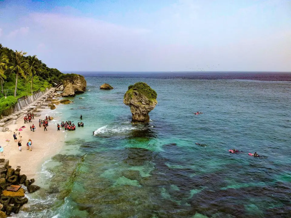
Xiaoliuqiu (aka Little Liuqiu, Lamay Island, or Lambai Island) is a small island paradise off the southwestern coast of Taiwan. The island is known for its clear water, amazing coral reefs, white sand beaches, and quiet laid back atmosphere. Only a short half hour boat ride from the Taiwan mainland, the island is easily accessible. In addition, the island is small enough that you can round the entire island by scooter in a matter of minutes.
Background: In 1622, a Dutch ship crashed on the island, two years before the Dutch began to rule Taiwan, and all but one of the crew members were killed by the aboriginal tribe living on the island at the time. In retaliation, the Dutch sent a force to massacre the natives on the island. 300 men, women, and children were suffocated alive in a large cave, and the rest of the people were put into slavery by the Dutch. This was known as the Lamey Island Massacre. Later Chinese people began inhabiting the island in 1645. Later the island fell into Qing, Japanese, and ROC rule. Currently the island is a township of Pingtung County with a population of over 10,000 people. Most of the people on the island rely on fishing and tourism for a living. The island also has one of the largest concentrations of temples in Taiwan. Xiaoliuqiu started to become a major tourist destination after 2004, reaching over 400,000 tourists per year. Regulated Inter-tidal Zones: in 2015 restrictions were placed on the inter-tidal zones in Xiaoliuqiu so that only those with a licensed guide could visit them and swimming is prohibited. These restrictions apply specifically to the Dafu Harbor inter-tidal zone (north of Dafu Harbor), Yanziping Beach, and the Shanfu Harbor Inter-tidal zone (north of Shanfu Harbor). Although there are other inter-tidal zones, these are not regulated. When to go: Anytime! Xiaoliuqiu is a tropical island that has warm water and temperatures (above 25 degrees Celsius) year round. However it is a little cooler and more windy during the winter, and you should be sure to avoid Typhoons during summer (ferries will be cancelled if there is a Typhoon). However, it can get really crowded during summer break in July-August, so go during the off-season to avoid the crowds. Tours: You can book multiple tours such as snorkeling, scuba diving, SUP experience, Kayak Sailing, submarine ride, and more through Klook or KKday, such as the Xiaoliuqiu Experience Pass. Booking a hotel: Booking accommodation on the island can be difficult in summer months and on weekends, when rooms can be fully booked for months in advance. Some places we have stayed at that I recommend are Yujing 6.8, which is a four story house near Dafu Harbor (you can book on Agoda here or Booking.com here), Boliu B&B (柏琉民宿) which is also a nice newly renovated hostel right on the main street near lots of restaurants (you can book on Agoda here or Booking.com here), Haichan Hostel which is a traditional three-sided Taiwanese mansion near the beach (you can book on Agoda here or Booking.com here), and Baisha Bay B&B which is a great place near the main harbor that is only one story so there are no stairs (you can book on Agoda here or Booking.com here). All of the owners of these places were very helpful, and even helped me to move my luggage and rent scooters. Some hostels require that you pay for my room in advance via bank wire transfer (this may not be an option if you are a foreign traveler, so make sure they accept credit cards if you do not have a Taiwan bank account), but you should not have to do this if you book through Agoda or another hotel booking site. Looking for a hotel? Find out where to stay in our Taiwan hotels guide or search for the best hotel deals in Taiwan here. You can also book Wifi and SIM cards for Taiwan on Gigago here. Need travel insurance? Compare prices on Insubuy here. Just to let you know, if you book using the links above, we get some commission at no cost to you, and you can help support our blog. You can click here to receive $5 USD on your first Klook purchase. How to get there: The only way to get there is via ferry from Donggang's Dongliu Ferry Terminal. The ferry ride takes about 30 minutes. There is a ferry leaving from Donggang roughly every hour from 7 AM to 5 PM. You can purchase a tickets at Donggang Fishing Harbor (東港漁港), or through a tour agency such as Klook here or here, or KKday. Parking: There is free scooter parking and paid car parking at the fishing harbor (30 NT per car), but the fishing harbor does not allow overnight parking. Overnight parking near the fishing harbor can cost up to 180 NT per day, so consider parking further away if you want to save money on parking. Public transport: There are many shuttles to and from Zuoying HSR station that leave hourly. The cost is about 200-300 NT per trip. You can book discounted HSR tickets on Klook here. You can book a shuttle from Zuoying to Donggang on Klook here. Scooter Rental: Price: expect 300-400 NT per day. You can book a scooter through Klook here or KKday here. You can also check out our scooter rental guide here. Be sure to book your rental in advance, especially during summer weekends. Ask for help from your hostel owner if needed. Helmet wearing is not very much enforced, but it's still the law, and you should definitely wear one for your own safety. Bicycle Rental: Looking for bicycle rentals in Taiwan? You can search on KKday here and search for tours on Klook here. You can also check out our Taiwan cycling guide here. Price: Ferry ride: about 410 NT per round trip, about 30 minutes. The public ferry goes to Dafu Fishing Harbor (大福漁港), and private ferries go to Baishawei Fishing Harbor (白沙尾漁港). There are ferries that leave at least hourly from about 8 AM to 5:00 PM. Scooter rental: about 300 NT per day. There is a gas station on the back side of the island. Snorkeling: about 300 NT per hour Scuba diving: around 2500 NT for 2-3 hours SUP experience: About 1000 NT for half a day. Kayak Sailing experience: about 2000 NT for 2 hours. Submarine adventure: about 2000 NT. You can purchase a tickets at Donggang Fishing Harbor (東港漁港), or through a tour agency such as Klook here or here, or KKday. Map: Please see below:
3 Comments
Pingtung is Taiwan's southernmost county and includes the best beaches, the best outer island, some of the best mountains, rivers, and waterfalls, and also interesting historical and cultural sites. It should definitely be on your list on your next visit to Taiwan.
When to go: Pingtung is great year round, but it can get a little hot in the summer, and Typhoon season and the heavy rain season last from about May to October. If you are afraid of the heat and rain then you can visit during winter when the temperatures are mild and the climate is dryer. Winters are windy and colder, but the water is still warm enough to swim in. Winter is a better time for activities like hiking and surfing. How to get there: By Car/Scooter: Take Provincial Highway 1 south to the bottom of Taiwan until it becomes Pingtung, or if in a car you can take National Freeway 3. Looking for scooter rental in Pingtung? Click here or here to search for options. If you are looking for car rentals, you can also search Qeeq here, Klook here, or KKday here. You can also check out our car rental guide here. By Bicycle: Cycling is the best way to enjoy Taiwan's landscapes if you have the time and energy. Looking for bicycle rentals in Taiwan? You can search on KKday here and search for tours on Klook here. You can also check out our Taiwan cycling guide here. By Bus: You can book tickets to travel to Pingtung via inter-city bus on Klook here. By TRA Train: There are many TRA stations in Pingtung which makes this a convenient option. You can book tickets to Pingtung via high speed rail (HSR) on Klook here or KKDay here, or book tickets via the normal train (TRA) on Klook here. By Plane: There are direct shuttle buses to Pintung from Kaohsing's Xiaogang (KHH) Airport. You can search for cheap flights in Taiwan here. Where to stay: Looking for a hotel? Find out where to stay in our Taiwan hotels guide or search for the best hotel deals in Taiwan here. We recommend booking through Agoda here, which provides the best quality selection of accommodation in Taiwan. I have stayed at many hostels and hotels in Pingtung, and even almost bought a house here. Some places that I have stayed at and can recommend are Nanwan Kiki (book on Agoda here, Booking.com here), a B&B next to Nanwan Bay, Kenting's most popular Beach. There are also a few decent hotels near Kenting Street Night Market like Kenting Star Inn 888 (book on Agoda here, Klook here, or Booking.com here), or Kenting Dajianshan Hotel (book on Agoda here or Booking.com here). You will notice that none of these hotels are five star resorts (I do not come to Kenting to waste my time at a resort, but you can still search Agoda, Booking.com, or Klook here for those) but they are in my opinion the above have the best value for the money. How to get around in Pingtung: 1. Rent a scooter - the best way to see Taiwan. Electric scooters that do not require a license are also readily available. For better range and speed, rent a gas scooter. You can search for scooter options here or here, and you can check out our scooter rental guide here. 2. Rent a car - more expensive than a scooter but may be more suitable for a large family. If you are looking for car rentals, you can also search Qeeq here, Klook here, or KKday here. You can also check out our car rental guide here. 3. Take the bus - cheap but slower than your own transportation, and it doesn't stop everywhere. You can book tickets to travel to Pingtung via inter-city bus on Klook here. 4. Cycle - you can rent a bicycle or bring your own. This is a great way to enjoy the scenery at a slower pace. Looking for bicycle rentals in Taiwan? You can search on KKday here and search for tours on Klook here. You can also check out our Taiwan cycling guide here. 5. Hire a taxi - more expensive than a rental car but perhaps more convenient. You can also search for a car charter service here or here. Tours and Activities in Pingtung: There are many activities available in Pingtung, such as snorkeling, diving, SUPing, surfing, submarine riding, and river tracing. You can find more tours of Pingtung on Klook here or KKday here. Just to let you know, if you book using the links above, we get some commission at no cost to you, and you can help support our blog. You can click here to receive $5 USD on your first Klook purchase. Map: See below for a map of places we will cover in this blog: 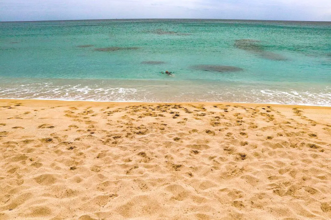
Yes, you should go to Kenting. Kenting has some of the best natural scenery in Taiwan, from beautiful white sand beaches that are warm year round to limestone mountains with hundreds of caves and waterfalls to explore. Although it may not be a world class beach resort destination yet, it should definitely be on your list on your trip to Taiwan.
Historical Background: The area around the Hengchun Peninsula was once coral that has been uplifted over millions of years. The first people to live here were Taiwan aboriginals, from the Paiwan and Puyuma tribes (who caused the Rover Incident as portrayed in Seqalu: Formosa 1867). Kenting was first settled by Han farmers and fishermen during the Qing Dynasty. The word Kenting comes from two words that mean cultivate (ken3 墾) and strong man (丁 ding1). During that time, a group of strong men (or Zhuang Ding 壯丁) came from Guangdong, who were basically Chinese pioneers of the area to cultivate the land, hence the area was named Kenting for them. The aboriginal people were mostly assimilated with the local Chinese population. The area was considered to be made into a park during the Japanese occupation due to it being the only tropical location in the Japanese Empire, but was never officially created. During the Japanese era, Nanwan was used as a whaling area and there were a few fishing villages here. The Whaling industry continued here in the ROC era until the international ban on whaling in 1986. Kenting National Park was established in 1984 as the first national park in Taiwan after WWII. Kenting became a major vacation spot, becoming a center for hostels and hotels for travelers. Kenting is considered by many to have the best beaches in Taiwan. This is because of its fine white sand and year-round warm temperatures and sunshine (it is in the tropical part of Taiwan after all). When to go: Summer is the best time to go because there is warm sunny weather and not a lot of wind. However, there are more people and there may be Typhoons. Winters are windy and colder, but the water is still warm enough to swim in. Winter is a better time for activities like hiking and surfing. How to get there: By Car/Scooter: Take provincial highway 1 south to the bottom of Taiwan until it becomes provincial highway 26. After that keep going past Hengchun into Kenting National Park. Looking for scooter rental in Kenting? Click here or here to search for options. If you are looking for car rentals, you can also search Qeeq here, Klook here, or KKday here. You can also check out our car rental guide here. By Bus: Busses leave daily to Kenting from Zuoying HSR station, Kaohsiung Station, and Pingtung. You can book tickets to Kenting via high speed rail (HSR) on Klook here or KKDay here, or book tickets via the normal train (TRA) on Klook here. You can book tickets to travel to Kenting via inter-city bus on Klook here. Once in Kenting, you can save money by booking Kenting's bus pass. By Plane: There are direct shuttle busses to Kenting from Kaohsing's Xiaogang (KHH) Airport. You can search for cheap flights in Taiwan here. By Bicycle: Cycling is the best way to enjoy Taiwan's landscapes if you have the time and energy. Looking for bicycle rentals in Taiwan? You can search on KKday here and search for tours on Klook here. You can also check out our Taiwan cycling guide here. Where to stay: Looking for a hotel? Find out where to stay in our Taiwan hotels guide or search for the best hotel deals in Taiwan here. We recommend booking through Agoda here, which provides the best quality selection of accommodation in Taiwan. I have stayed at many hostels and hotels in Pingtung, and even almost bought a house here. Some places that I have stayed at and can recommend are Nanwan Kiki (book on Agoda here or Booking.com here), a B&B next to Nanwan Bay, Kenting's most popular Beach. There are also a few decent hotels near Kenting Street Night Market like Kenting Star Inn 888 (book on Agoda here, Klook here, or Booking.com here), or Kenting Dajianshan Hotel (book on Agoda here or Booking.com here). You will notice that none of these hotels are five star resorts (I do not come to Kenting to waste my time at a resort, but you can still search Agoda, Booking.com, or Klook here for those) but they are in my opinion the above have the best value for the money. How to get around in Kenting: 1. Rent a scooter - the best way to see Taiwan. Electric scooters that do not require a license are also readily available. For better range and speed, rent a gas scooter. You can search for scooter options here or here, and you can check out our scooter rental guide here. 2. Rent a car - more expensive than a scooter but may be more suitable for a large family. If you are looking for car rentals, you can also search Qeeq here, Klook here, or KKday here. You can also check out our car rental guide here. 3. Take the Kenting bus - cheap but slower than your own transportation, and it doesn't stop everywhere. You can book tickets to travel to Kenting via inter-city bus on Klook here. 4. Cycle - you can rent a bicycle or bring your own. This is a great way to enjoy the scenery at a slower pace. You can search on KKday here and search for tours on Klook here. You can also check out our Taiwan cycling guide here. 5. Hire a taxi - more expensive than a rental car but perhaps more convenient. You can also search for a car charter service here or here. Tours and Activities in Kenting: There are many activities available in Kenting, such as snorkeling, diving, SUPing, surfing, submarine riding, and river tracing. You can find more tours of Kenting on Klook here or KKday here. Just to let you know, if you book using the links above, we get some commission at no cost to you, and you can help support our blog. You can click here to receive $5 USD on your first Klook purchase. Places we will cover in this blog:
Map of sites in this blog: 
This month marks the 10th anniversary of this blog, so to celebrate I am making a blog tracing back our first round-island trip lasting 14 days and 13 nights made in 2014. During this journey we rented a car in Taipei, and circled Taiwan clockwise, visiting Taroko Gorge, Kenting, Xiaoliuqiu, Alishan, Sun Moon Lake, and many more places along the way. I am the kind of guy who likes to bask in nostalgia, but also I hope that laying out this experience in the open as well as the lessons we learned about travel in Taiwan along the way (and what I know now in 2024) will be helpful to other foreigners coming to Taiwan.
Some background on why this trip happened: This was not our first trip to Taiwan. Scott and I had been Latter-day Saint missionaries in Taiwan from 2011 to 2012 in the Taichung Mission, which covers Taichung to Pingtung but nothing north or east of that. We still had a lot of friends in Taiwan that we missed, we missed Taiwanese food, and there were the entire north and east parts of the island for us to explore. We decided it would be a once-in-a-lifetime opportunity to tour Taiwan now because later on in our lives we would likely have work and family obligations that would not allow us to take a 14-day trip around Taiwan. Being poor college students at the time, we had a very limited budget (for reference, I was making 700 USD a month as a janitor and I could only save about half of that after rent and food). Originally another friend planned to come with us, but he backed out because he got married. Scott's brother Matt decided to come along too. Just so you know, Scott and I know Chinese, but Matt doesn't. It makes traveling easier to know the language but you can still get by in Taiwan without it. The Plane Ride: We took the cheapest flight available on Shenzhen Airlines, which had many flights for cheap to the US at the time. For 700 USD we bought a round trip from LA to Beijing to Taipei and back. Renting a car in Taiwan: Before we began our trip, we planned on rounding the island by Scooter. This can be a fun way to explore Taiwan. As a side note, you can book a Motorcycling experience on Klook here, or a half-day Motorbike Tour on KKday here. If you are looking for a multi-day, in-depth tour of Taiwan via motorbike, we recommend contacting [email protected] who schedules regular 10-day motorbike tours of Taiwan. The tour guide is a long-term expat in Taiwan who has been giving riding tours of Taiwan for 16 years now. You can also check out our scooter rental guide here. After crunching the numbers, we figured that we could rent a car for just as cheap as three scooters, and we wouldn't have to worry about rain or luggage. A scooter would be 300 NT per day, and for three people 900 NT per day, but we found a car rental place that would rent us a small Nissan March for 700 NT a day (that car company was called Good Cars 固得汽車 in Zhonghe, you can find their information in our Taiwan Car Rental Guide here). After arriving at Taoyuan International Airport, we took a bus to Taipei and made our way to Zhonghe at a friend's house and picked up the rental car. At the end of the trip, we found the price was a few thousand NT more than we expected because of highway tolls (about 1.5 NT per kilometer). SIM Card: I bought a pre-paid SIM card from Taiwan Mobile for 500 TWD that lasted the whole trip. I think it was only a few GB of data, but I had a crappy phone and was not using much data. Map: Check out a map of places we visited on this trip below: 
Xisheng Old Street (aka Wugoushui Xisheng Old Street) is a historical street in the township of Wanluan in rural Pingtung dating back over 300 years to the Qing Dynasty. Here you can find a group of well-preserved historical Hakka buildings that are religious sites with very few other tourists around. It is definitely worth a visit on your next trip to Pingtung County.
Background: For millennia Pingtung had been inhabited by plains aboriginal groups. Their biggest settlement was called Ahou, on the current site of Pingtung City, and another settlement to the northwest along the Gaoping River was called Aligang, which is where Ligang gets its name. The first Chinese settlers came to the area in the late 1600s during the Kingdom of Tungming and Qing Dynasty. Before that time, the area was known as a place of exile for Chinese criminals. During the Qing Dynasty, the area was part of Fengshan County. The first settlers to Neipu were Hakka people who came from China in 1710. They built a Mazu temple here which became the religious center of the area. Wugoushui Xisheng Old Street is so named because from olden times there were five ditches built (original meaning of Wugoushui 五溝水), therefore the village here is named Wugoushui. Xisheng Old Street in Wugoushui Village soon became the economic and cultural center of the area as well. Many of the buildings in the area have remained unchanged since the Qing Dynasty. Although there are many shops and restaurants in town, it is not a "touristy" place that attracts crowds of people. The area is usually not very busy even on weekends. Hours: 24/7 Price: Free Tours and Activities in Pingtung: There are many activities available in Pingtung, such as snorkeling, diving, SUPing, surfing, submarine riding, and river tracing. You can find more tours of Kenting on Klook here or KKday here. Where to stay: Looking for a hotel? Find out where to stay in our Taiwan hotels guide or search for the best hotel deals in Taiwan here. We recommend booking through Agoda here, which provides the best quality selection of accommodation in Taiwan. I have stayed at many hostels and hotels in Pingtung, and even almost bought a house here. Some places that I have stayed at and can recommend are Nanwan Kiki (book on Agoda here, Booking.com here), a B&B next to Nanwan Bay, Kenting's most popular Beach. There are also a few decent hotels near Kenting Street Night Market like Kenting Star Inn 888 (book on Agoda here, Klook here, or Booking.com here), or Kenting Dajianshan Hotel (book on Agoda here or Booking.com here). You will notice that none of these hotels are five star resorts (I do not come to Kenting to waste my time at a resort, but you can still search Agoda, Booking.com, or Klook here for those) but they are in my opinion the above have the best value for the money. How to get there: By Car/Scooter: Take Provincial Highway 1 south to the bottom of Taiwan until it becomes Neipu. Then travel east to Wanluan Township until you reach the old street. Looking for scooter rental in Pingtung? Click here or here to search for options. You can also check out our scooter rental guide here. If you are looking for car rentals, you can also search Qeeq here, Klook here, or KKday here. You can also check out our car rental guide here. By Bus: You can reach Ligang from Pingtung Bus 8220 or 8217. You can book tickets to Kaohsiung via high speed rail (HSR) on Klook here or KKDay here, or book tickets via the normal train (TRA) on Klook here. You can book tickets to travel to Pingtung via inter-city bus on Klook here. By Bicycle: Cycling is the best way to enjoy Taiwan's landscapes if you have the time and energy. Looking for bicycle rentals in Taiwan? You can search on KKday here and search for tours on Klook here. You can also check out our Taiwan cycling guide here. Map: Please see below: 
Neipu Yangjiyuan Old Street is a historical street in the township of Neipu in rural Pingtung dating back to the Qing Dynasty. Here you can find a group of well preserved historical Hakka buildings and religious sites with very few other tourists around. It is definitely worth a visit on your next trip to Pingtung.
Background: For millennia Pingtung had been inhabited by plains aboriginal groups. Their biggest settlement was called Ahou, on the current site of Pingtung City, and another settlement to the northwest along the Gaoping River was called Aligang, which is where Ligang gets its name. The first Chinese settlers came to the area in the late 1600s during the Kingdom of Tungming and Qing Dynasty. Before that time, the area was known as a place of exile for Chinese criminals. During the Qing Dynasty, the area was part of Fengshan County. The first settlers to Neipu were Hakka people who came from China in 1722. They built a Mazu temple here which became the religious center of the area. Neipu Yangjiyuan Old Street is so named because in the olden times it was a place where goats gathered (the original meaning of Yangjiyuan 羊聚集之地). Yangjiyuan Old Street soon became the economic and cultural center of the area as well. Many of the buildings in the area have remained unchanged since the Qing Dynasty. Although there are many shops and restaurants in town, it is not a "touristy" place that attracts crowds of people. The area is usually not very busy even on weekends. Hours: 24/7 Price: Free Tours and Activities in Pingtung: There are many activities available in Pingtung, such as snorkeling, diving, SUPing, surfing, submarine riding, and river tracing. You can find more tours of Kenting on Klook here or KKday here. Where to stay: Looking for a hotel? Find out where to stay in our Taiwan hotels guide or search for the best hotel deals in Taiwan here. We recommend booking through Agoda here, which provides the best quality selection of accommodation in Taiwan. I have stayed at many hostels and hotels in Pingtung, and even almost bought a house here. Some places that I have stayed at and can recommend are Nanwan Kiki (book on Agoda here, Booking.com here), a B&B next to Nanwan Bay, Kenting's most popular Beach. There are also a few decent hotels near Kenting Street Night Market like Kenting Star Inn 888 (book on Agoda here, Klook here, or Booking.com here), or Kenting Dajianshan Hotel (book on Agoda here or Booking.com here). You will notice that none of these hotels are five star resorts (I do not come to Kenting to waste my time at a resort, but you can still search Agoda, Booking.com, or Klook here for those) but they are in my opinion the above have the best value for the money. How to get there: By Car/Scooter: Take Provincial Highway 1 East from Kaohsiung to Pingtung until you reach Neipu. From National Highway 3, you can also get off the 407 exit to Linluo and head east just about 1 KM to Neipu. Looking for scooter rental in Pingtung? Click here or here to search for options. You can also check out our scooter rental guide here. If you are looking for car rentals, you can also search Qeeq here, Klook here, or KKday here. You can also check out our car rental guide here. By Bus: You can reach Neipu from Pingtung via bus. You can book tickets to Kaohsiung via high speed rail (HSR) on Klook here or KKDay here, or book tickets via the normal train (TRA) on Klook here. You can book tickets to travel to Pingtung via inter-city bus on Klook here. By Bicycle: Cycling is the best way to enjoy Taiwan's landscapes if you have the time and energy. Looking for bicycle rentals in Taiwan? You can search on KKday here and search for tours on Klook here. You can also check out our Taiwan cycling guide here. Map: Please see below: 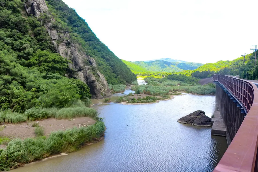
Shimen Ancient Battlefield (aka Shimen Historic Battlefield Macacukes 石門古戰場) in Mudan Township of Pingtung is where local Paiwan indigenous people fought a Japanese invading force in the aftermath of the Mudan Incident. Here the Paiwan people were able to stall the Japanese advance but were ultimately defeated and agreed to stop attacking shipwrecked ships. This spot along the river played an important part in Taiwan's history and is also important for the local Paiwan people who still live there. Now you can enjoy the natural scenery, historical markers, and hiking trails nearby.
Background: In 1871, a ship from the Ryukyuan Kingdom was shipwrecked near Mudan Village, and 54 Ryukyu men were massacred by the local Paiwan aboriginals. Even though the Ryukyuan kingdom was independent, it asked for help from the Qing Dynasty, its main trading partner, to pacify the Taiwanese aboriginals. Later in 1872, Japan dethroned the King of the Ryukyuan Kingdom and asked that the Qing Dynasty be held responsible for the massacre. The Qing denied having control over that region of Taiwan, so Japan sent soldiers to avenge those massacred as part of the 1874 invasion of Taiwan. A war ensued, and Japan entered Taiwan at Sheliao (near Guishan) on the Hengchun Peninsula and was stopped for a while at Shimen. Shimen literally means stone gate, referring to the narrow canyon that the Sichong River runs through here. The Japanese army was eventually successful at moving past Shimen and burned all nearby Paiwan Villages. The villagers promised to stop attacking shipwrecked sailors and began flying the Japanese flag which they saw as a sign of peace, and which the Japanese saw as a claim of jurisdiction. In the end, 561 Japanese soldiers died from disease while only 12 were killed in battle. 89 Paiwan aboriginals were killed in battle. Japan then negotiated with China with the help of American and British advisors, and China recognized Japanese control of the Ryukyu Islands and made payment to Japan for peacekeeping in the area. The Japanese finally withdrew from Taiwan in December 1875. In the end, the battle helped Japan solidify its influence on Taiwan and the Ryukyu Islands, emboldening it later to take over Taiwan. Hours: 24/7 Price: Free Tours and Activities in Pingtung: There are many activities available in Pingtung, such as snorkeling, diving, SUPing, surfing, submarine riding, and river tracing. You can find more tours of Kenting on Klook here or KKday here. Accommodation: Looking for a hotel? Find out where to stay in our Taiwan hotels guide or search for the best hotel deals in Taiwan here. We recommend booking through Agoda here, which provides the best quality selection of accommodation in Taiwan. I have stayed at many hostels and hotels in Kenting, and even almost bought a house here. Some places that I have stayed at and can recommend are Nanwan Kiki (book on Agoda here, Booking.com here), a B&B next to Nanwan Bay, Kenting's most popular Beach. There are also a few decent hotels near Kenting Street Night Market like Kenting Star Inn 888 (book on Agoda here, Klook here, Hotels.com here, Expedia here, or Booking.com here), or Kenting Dajianshan Hotel (book on Agoda here, Booking.com here, Hotels.com here, or Expedia here). You will notice that none of these hotels are five star resorts (I do not come to Kenting to waste my time at a resort, but you can still search Agoda, Booking.com, Hotels.com, or Expedia for those) but they are in my opinion the above have the best value for the money. How to get there: By Car/Scooter: Take Provincial Highway 1 south to the bottom of Taiwan until it Checheng. Then travel east toward Mudan Township until you reach the Shimen Historic Battlefield memorial marker. Looking for scooter rental in Pingtung? Click here or here to search for options. You can also check out our scooter rental guide here. If you are looking for car rentals, you can also search Qeeq here, Klook here, or KKday here. You can also check out our car rental guide here. By Bus: You can reach Mudan from Pingtung Bus 1773 or 302, but it will take over three hours. You can book tickets to Kaohsiung via high speed rail (HSR) on Klook here or KKDay here, or book tickets via the normal train (TRA) on Klook here. You can book tickets to travel to Pingtung via inter-city bus on Klook here. By Bicycle: Cycling is the best way to enjoy Taiwan's landscapes if you have the time and energy. Looking for bicycle rentals in Taiwan? You can search on KKday here and search for tours on Klook here. You can also check out our Taiwan cycling guide here. Map: Please see below: 
Houwan Beach in Kenting is a small beach near the Aquarium. It features a short yellow sandy beach, as well as clear water that is relatively warm year round. In addition, the beach has sunshine for most of the year. Popular activities include surfing, swimming, and sunbathing. It has everything you would want from a Kenting beach but it is smaller and there are fewer people than other beaches.
Background: Houwan is a small fishing town in Kenting after which the beach is named. The name literally means "back bay" in Chinese. Kenting was first settled by Chinese farmers during the Qing Dynasty. The word Kenting comes from two words that mean cultivate (ken3 墾) and strong man (丁 ding1). During that time, a group of strong men (or Zhuang Ding 壯丁) came from Guangdong, who were basically Chinese pioneers of the area to cultivate the land, hence the area was named Kenting for them. The area was considered to be made into a park during the Japanese occupation due to it being the only tropical location in the Japanese Empire, but was never officially created. Kenting National Park was established in 1984 as the first national park in Taiwan after WWII. Kenting became a major vacation spot, becoming a center for hostels and hotels for travelers. Kenting is considered by many to have the best beaches in Taiwan. This is because of its fine white sand and year-round warm temperatures and sunshine (it is in the tropical part of Taiwan after all). Usually, this beach is free of people and crowds even on weekends. Hours: 24/7 Price: Free When to go: Summer! It's when the water is warmest and the sun is hottest. However there will be more people in summer, and there could be Typhoons. Spring and Fall are also good times to go, as there will be less visitors and cooler temperatures. Winter is an okay time to go as well, it will be warmer than the rest of Taiwan and the water will still be warm enough to swim in. How to get there: By Car/Scooter: Take Provincial highway 1 south to the bottom of Taiwan until it becomes Provincial highway 26. After that keep going past Checheng and then turn west onto Houwan Road until you reach the beach. There is free parking near the beach. Looking for scooter rental in Pingtung? Click here or here to search for options. You can also check out our Taiwan scooter rental guide here. If you are looking for car rentals, you can also search here. You can check out our car rental guide here. By Bus: Busses leave daily to Kenting from Zuoying HSR station, Kaohsiung Station, and Pingtung. Get off at Shanghouwan上後灣. You can book tickets to Pingtung via high speed rail (HSR) on Klook here or KKDay here, or book tickets via the normal train (TRA) on Klook here. You can book tickets to travel to Pingtung via inter-city bus on Klook here. By Plane: There are direct shuttle busses to Kenting from Kaohsing's Xiaogang (KHH) Airport. You can book cheap flights to Kinmen on Trip.com or CheapO Air. You can also search for cheap flights in Taiwan on Kiwi here. Accommodation: I have stayed at many hostels and hotels in Kenting, and even almost bought a house here. Some places that I have stayed at and can recommend are Nanwan Kiki (book on Agoda here, Booking.com here), a B&B next to Nanwan Bay, Kenting's most popular Beach. There are also a few decent hotels near Kenting Street Night Market like Kenting Star Inn 888 (book on Agoda here, Klook here, Hotels.com here, Expedia here, or Booking.com here), or Kenting Dajianshan Hotel (book on Agoda here, Booking.com here, Hotels.com here, or Expedia here). You will notice that none of these hotels are five star resorts (I do not come to Kenting to waste my time at a resort, but you can still search Agoda, Booking.com, Hotels.com, or Expedia for those) but they are in my opinion the above have the best value for the money. Looking for a hotel? Find out where to stay in our Taiwan hotels guide or search for the best hotel deals in Taiwan here. We recommend booking through Agoda here, which provides the best quality selection of accommodation in Taiwan. Tours and Activities in Kenting: There are many activities available such as snorkeling, diving, SUPing, surfing, submarine riding, and river tracing. You can find more tours of Kenting on Klook here or KKday here. Map: Please see below: 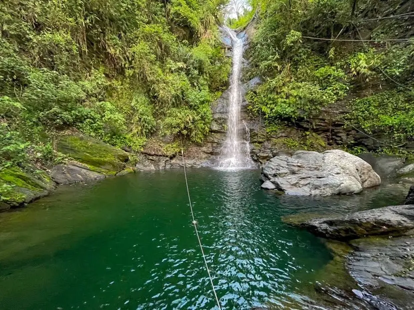
Wutan Waterfall (武潭瀑布) in Taiwu Township of Pingtung County is an easily accessible waterfall that is usually free of people. This area of mountains in southern Taiwan has almost unlimited swimmable waterfalls that are devoid of people. It is definitely a fun trip in the mountains that will not take too much time, and a great place to enjoy nature.
Background: Wutan Waterfall is about 20 meters high and features a large and deep swimming pool. It is named after Taiwu Village, which is an aboriginal village within walking distance down the hill. The holes in the rocks have been carved out of the rocks after thousands of years of erosion. There are stone steps along the side of the waterfall as well as ropes. The waterfall can get busy during holidays and weekends. Hours: 24/7 Price: Free Difficulty: Easy: 20 meters in length (one way) and 10 meters in elevation gain. The whole hike should take about two minutes from the road. Where to stay: Looking for a hotel? Find out where to stay in our Taiwan hotels guide or search for the best hotel deals in Taiwan here. We recommend booking through Agoda here, which provides the best quality selection of accommodation in Taiwan. I have stayed at many hostels and hotels in Pingtung, and even almost bought a house here. Some places that I have stayed at and can recommend are Nanwan Kiki (book on Agoda here, Booking.com here), a B&B next to Nanwan Bay, Kenting's most popular Beach. There are also a few decent hotels near Kenting Street Night Market like Kenting Star Inn 888 (book on Agoda here, Klook here, or Booking.com here), or Kenting Dajianshan Hotel (book on Agoda here or Booking.com here). You will notice that none of these hotels are five star resorts (I do not come to Kenting to waste my time at a resort, but you can still search Agoda, Booking.com, or Klook here for those) but they are in my opinion the above have the best value for the money. Tours: You can go book a river trace in Pingtung on Klook here or KKday here. How to get there: By Car/Scooter: From Pingtung, take Provincial Highway 1 souththeast until you reach Neipu and then turn southeast until you hit the 185. Drive until you reach Taiwu Village and turn up the mountain past the village to the waterfall. The waterfall is easy to find along the side of the road and there is some parking along the side of the road. Looking for scooter rental in Kenting? Click here or here to search for options. You can also check out our Taiwan scooter rental guide here. If you are looking for car rentals, you can also search Qeeq here, Klook here, or KKday here. You can also check out our car rental guide here. By Bus: You can take bus 8212 to Wutan, then it is about a 30 minute walk to the waterfall. You can book tickets to Pingtung via high speed rail (HSR) on Klook here or KKDay here, or book tickets via the normal train (TRA) on Klook here. You can book tickets to travel to Pingtung via inter-city bus on Klook here. By Bicycle: Cycling is the best way to enjoy Taiwan's landscapes if you have the time and energy. Looking for bicycle rentals in Taiwan? You can search on KKday here and search for tours on Klook here. You can also check out our Taiwan cycling guide here. Map: Please see below: 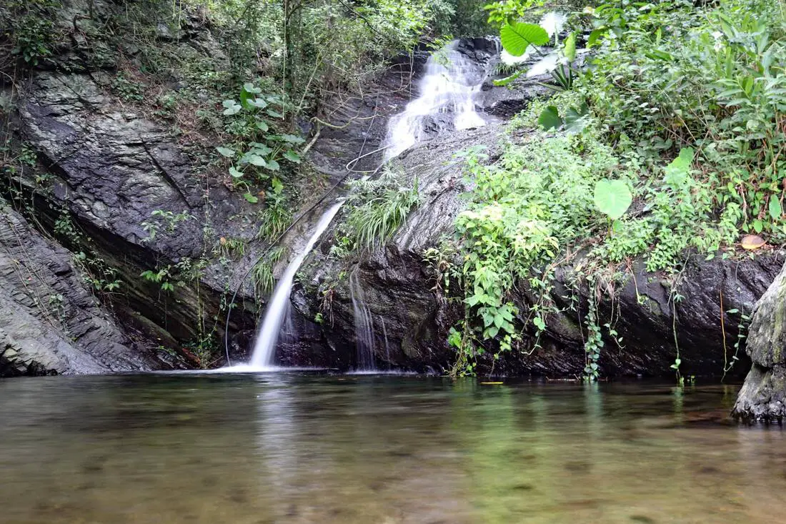
Koushe Waterfall (口社瀑布) near Koushe Village in Gaoshu Township of Pingtung is an easily accessible, swimmable waterfall right next to the side of the road. This area of mountains in southern Taiwan has almost unlimited swimmable waterfalls that are devoid of people. It is definitely a fun trip in the mountains that will not take too much time, and a great place to enjoy nature.
Background: Koushe Waterfall is about 12 meters high and features a large swimming pool. It is named for Koushe Village, which is an aboriginal village within walking distance down the hill. The holes in the rocks have been carved out of the rocks after thousands of years of erosion, and there is a rope climb and trail along the side of the waterfalls, which can be climbed in just a few minutes. Hours: 24/7 Price: Free Difficulty: Easy: 20 meters in length (one way) and 10 meters in elevation gain. The whole hike should take about two minutes from the road. Accommodation: Looking for a hotel? Find out where to stay in our Taiwan hotels guide or search for the best hotel deals in Taiwan here. We recommend booking through Agoda here, which provides the best quality selection of accommodation in Taiwan. I have stayed at many hostels and hotels in Pingtung, and even almost bought a house here. Some places that I have stayed at and can recommend are Nanwan Kiki (book on Agoda here, Booking.com here), a B&B next to Nanwan Bay, Kenting's most popular Beach. There are also a few decent hotels near Kenting Street Night Market like Kenting Star Inn 888 (book on Agoda here, Klook here, Hotels.com here, Expedia here, or Booking.com here), or Kenting Dajianshan Hotel (book on Agoda here, Booking.com here, Hotels.com here, or Expedia here). You will notice that none of these hotels are five star resorts (I do not come to Pingtung to waste my time at a resort, but you can still search Agoda, Booking.com, Hotels.com, or Expedia for those) but they are in my opinion the above have the best value for the money. Tours: You can go book a river trace in Pingtung on Klook here or KKday here. How to get there: By Car/Scooter: From Pingtung, take Provincial Highway 27 northeast until you reach Gaoshu and then turn southeast until you hit the 185. Drive until you reach Koushe Village and turn up the mountain just before the village. The waterfall is easy to find along the side of the road. Looking for scooter rental in Kenting? Click here or here to search for options. You can also check out our Taiwan scooter rental guide here. If you are looking for car rentals, you can also search here. You can also check out our car rental guide here. By Bus: There is no public transportation to this area. Consider taking a taxi or renting a vehicle. You can book tickets to Pingtung via high speed rail (HSR) on Klook here or KKDay here, or book tickets via the normal train (TRA) on Klook here. You can book tickets to travel to Pingtung via inter-city bus on Klook here. By Bicycle: Cycling is the best way to enjoy Taiwan's landscapes if you have the time and energy. Looking for bicycle rentals in Taiwan? You can search on KKday here and search for tours on Klook here. You can also check out our Taiwan cycling guide here. Map: Please see below: 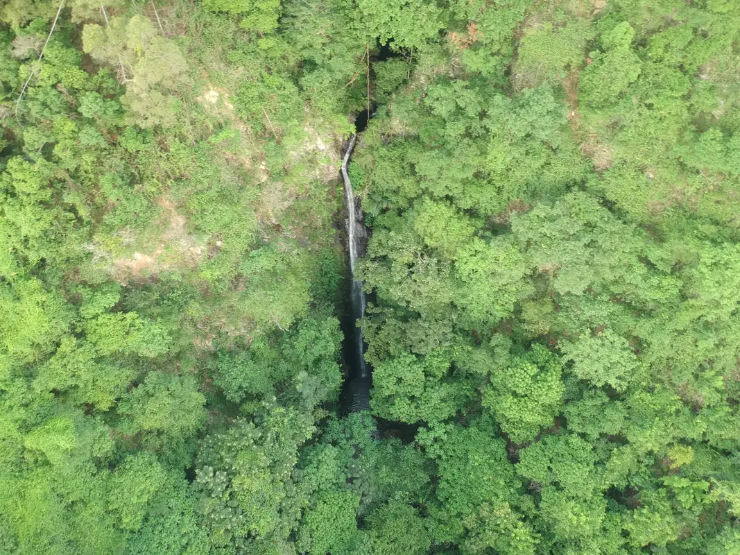
Dajin Waterfall is a large waterfall in Gaoshu township of Pingtung County. The hike here is relatively easy along a paved path, and there are great views of Pingtung along the way. It is definitely a fun trip in the mountains that will not take too much time, and a great place to enjoy nature.
Background: Dajin Waterfall is about 20 meters high, and falls at about 90 degrees. and its name comes from the roughly seven holes in the rocks between waterfalls. The holes in the rocks have been carved out of the rocks after thousands of years of erosion, and there is a rope climb and trail along the side of the waterfalls, which can be climbed in less than an hour. Currently the nearest parking lot lies on private property and the property owner collects parking fees in cash. Hours: 24/7 Price: Free Difficulty: Easy: 1 KM in length (one way) and 100 meters in elevation gain. The whole hike should take about an hour. Where to stay: Looking for a hotel? Find out where to stay in our Taiwan hotels guide or search for the best hotel deals in Taiwan here. We recommend booking through Agoda here, which provides the best quality selection of accommodation in Taiwan. I have stayed at many hostels and hotels in Pingtung, and even almost bought a house here. Some places that I have stayed at and can recommend are Nanwan Kiki (book on Agoda here, Booking.com here), a B&B next to Nanwan Bay, Kenting's most popular Beach. There are also a few decent hotels near Kenting Street Night Market like Kenting Star Inn 888 (book on Agoda here, Klook here, or Booking.com here), or Kenting Dajianshan Hotel (book on Agoda here or Booking.com here). You will notice that none of these hotels are five star resorts (I do not come to Kenting to waste my time at a resort, but you can still search Agoda, Booking.com, or Klook here for those) but they are in my opinion the above have the best value for the money. Tours: You can go book a river trace in Pingtung on Klook here or KKday here. How to get there: By Car/Scooter: From Pingtung, take Provincial Highway 27 northeast until you reach Xinfeng Village in Gaoshu and then turn southeast until you hit the mountains. Drive to the end of the road and that is where the trailhead starts. Looking for scooter rental in Kenting? Click here or here to search for options. You can also check out our Taiwan scooter rental guide here. Looking for scooter rental in Pingtung? Click here or here to search for options. If you are looking for car rentals, you can also search Qeeq here, Klook here, or KKday here. You can also check out our car rental guide here. By Bus: You can take bus 8218 bus to Weiliao Station, but then it is a 30 minute walk to the trailhead. You can book tickets to Pingtung via high speed rail (HSR) on Klook here or KKDay here, or book tickets via the normal train (TRA) on Klook here. You can book tickets to travel to Pingtung via inter-city bus on Klook here. By Bicycle: Cycling is the best way to enjoy Taiwan's landscapes if you have the time and energy. Looking for bicycle rentals in Taiwan? You can search on KKday here and search for tours on Klook here. You can also check out our Taiwan cycling guide here. Map: Please see below: 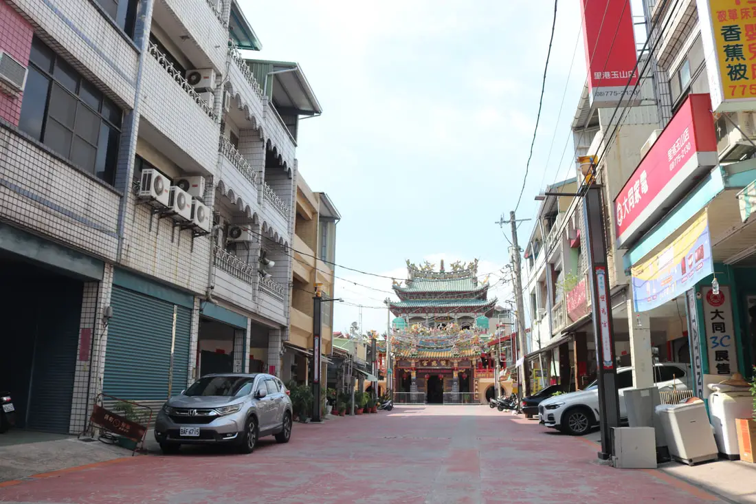
Ligang Old Street is a historical small town in rural Pingtung dating back to the Qing Dynasty. At one time it even had a city wall built around it. Here you can find historical buildings are religious sites without any other tourists bothering you. There is also a night market and morning wet market to explore. It is definitely worth a visit on your next trip to Pingtung.
Please note this is referring to the old street in Pingtung. For the old street in Changhua, see our blog on Lukang Old Street here. Background: For millennia Pingtung had been inhabited by plains aboriginal groups. Their biggest settlement was called Ahou, on the current site of Pingtung City, and another settlement to the northwest along the Gaoping River was called Aligang, which is where Ligang gets its name. The first Chinese settlers came to the area in the late 1600s during the Kingdom of Tungming and Qing Dynasty. Before that time, the area was known as a place of exile for Chinese criminals. During the Qing Dynasty, the area was part of Fengshan County. During these times there were often fights among local clans such as Hakka, Cantonese, and Min peoples that came from different parts of China. For protection against rebellions, a city wall was built around Ligang, but was later destroyed during the Japanese Era. The Japanese also relocated two villages that were close to the Gaoping River near Ligang Old Street. Currently, the population of Ligang is roughly 25,000 people, a number which has remained constant for nearly 60 years. Normally there are not many people on the old street and the area is not very busy. Hours: Ligang Old Street: 24/7 Ligang Night Market (里港夜市): 5 PM - 10:30 PM Thursday and Sunday evenings Ligang Morning Vegetable Market (里港市場): 8 AM - 12 PM Tuesday - Sunday Price: Free Tours and Activities in Pingtung: There are many activities available in Pingtung, such as snorkeling, diving, SUPing, surfing, submarine riding, and river tracing. You can find more tours of Kenting on Klook here or KKday here. Where to stay: Looking for a hotel? Find out where to stay in our Taiwan hotels guide or search for the best hotel deals in Taiwan here. We recommend booking through Agoda here, which provides the best quality selection of accommodation in Taiwan. I have stayed at many hostels and hotels in Pingtung, and even almost bought a house here. Some places that I have stayed at and can recommend are Nanwan Kiki (book on Agoda here, Booking.com here), a B&B next to Nanwan Bay, Kenting's most popular Beach. There are also a few decent hotels near Kenting Street Night Market like Kenting Star Inn 888 (book on Agoda here, Klook here, or Booking.com here), or Kenting Dajianshan Hotel (book on Agoda here or Booking.com here). You will notice that none of these hotels are five star resorts (I do not come to Kenting to waste my time at a resort, but you can still search Agoda, Booking.com, or Klook here for those) but they are in my opinion the above have the best value for the money. How to get there: By Car/Scooter: Take Provincial Highway 22 East from Kaohsiung to Pingtung until you reach Ligang. From National Highway 3, you can also get off the 391 exit to Jiuru and head north just about 1 KM to Ligang. The Confucius Temple is on Shengli Road in the middle of the city. Looking for scooter rental in Pingtung? Click here or here to search for options. If you are looking for car rentals, you can also search Qeeq here, Klook here, or KKday here. You can also check out our car rental guide here. By Bus: You can reach Ligang from Pingtung Bus 8220 or 8217. You can book tickets to Kaohsiung via high speed rail (HSR) on Klook here or KKDay here, or book tickets via the normal train (TRA) on Klook here. You can book tickets to travel to Pingtung via inter-city bus on Klook here. By Bicycle: Cycling is the best way to enjoy Taiwan's landscapes if you have the time and energy. Looking for bicycle rentals in Taiwan? You can search on KKday here and search for tours on Klook here. You can also check out our Taiwan cycling guide here. Map: Please see below: 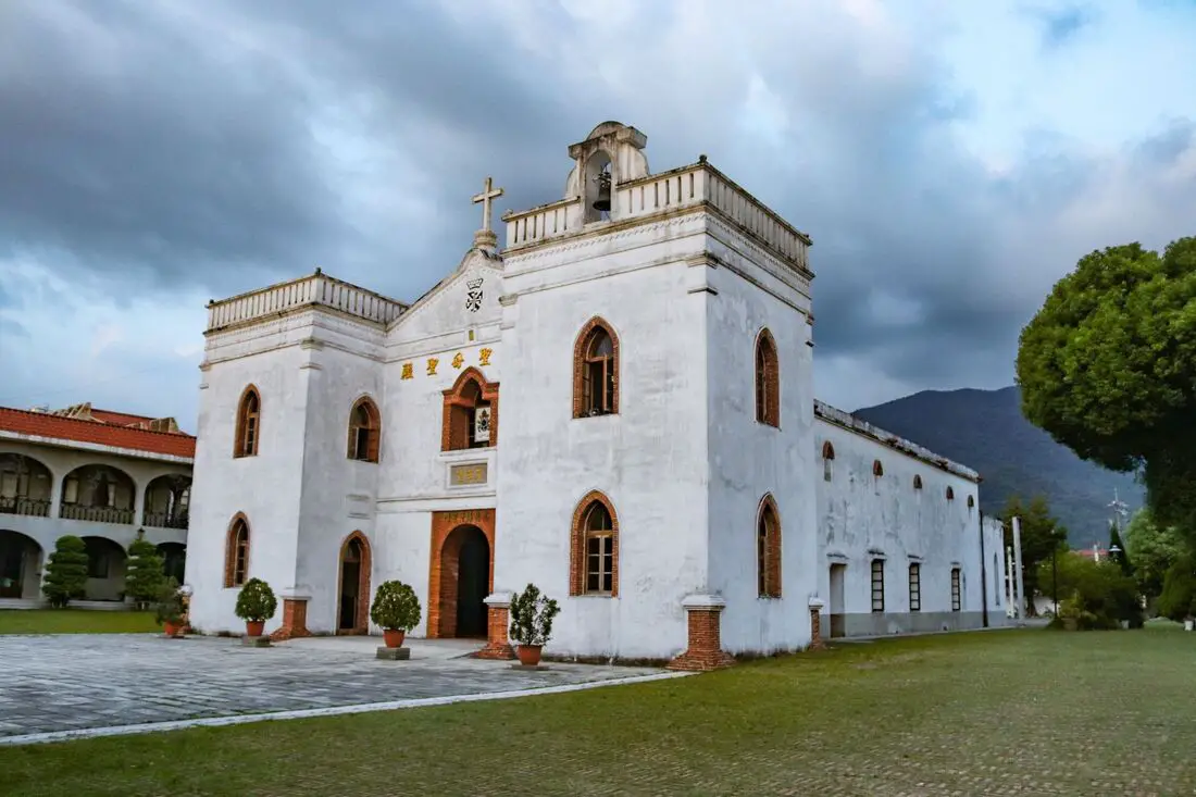
Wanjin Catholic Basilica (aka Wanchin Basilica of the Immaculate Conception) in Wanluan Township of Pingtung dates back to 1861 and was the first Basilica church and the oldest preserved church in Taiwan. It is also the beginning of Wanxing Road, a historic area in the town. Wanjing Night Market also lies on Wanxing Road; it's the most local night market you will ever find in Taiwan.
Background: After the treaty of Tianjin in 1858, the Qing Dynasty allowed Christianity in Taiwan. Catholic Priest Father Fernando Sainz arrived in Kaohsiung in 1859, from the Philippines. At the end of that year, he bought the piece of land where the current church sits for 62 Spanish silver coins. The original church was built with mud brick and completed in 1863 but was damaged in an earthquake in 1865. The church was rebuilt in its current form in 1870 using Spanish Fortress Architecture. Father Fernando Sainz returned to the Philippines in 1869 and died in Manila in 1895. The church underwent further renovations in the mid 1900s. In 1984, the church was named a Basilica by Pope John Paul II, the first church in Taiwan to receive this title. Later an Immaculate Conception Dominican Residence and visitor center were built on the grounds. Hours: 6:30 AM to 9:30 PM Wanjin Night Market: Fridays from 6 Pm to 10 PM Price: Free Tours and Activities in Pingtung: There are many activities available in Pingtung, such as snorkeling, diving, SUPing, surfing, submarine riding, and river tracing. You can find more tours of Kenting on Klook here or KKday here. Where to stay: Looking for a hotel? Find out where to stay in our Taiwan hotels guide or search for the best hotel deals in Taiwan here. We recommend booking through Agoda here, which provides the best quality selection of accommodation in Taiwan. I have stayed at many hostels and hotels in Pingtung, and even almost bought a house here. Some places that I have stayed at and can recommend are Nanwan Kiki (book on Agoda here, Booking.com here), a B&B next to Nanwan Bay, Kenting's most popular Beach. There are also a few decent hotels near Kenting Street Night Market like Kenting Star Inn 888 (book on Agoda here, Klook here, or Booking.com here), or Kenting Dajianshan Hotel (book on Agoda here or Booking.com here). You will notice that none of these hotels are five star resorts (I do not come to Kenting to waste my time at a resort, but you can still search Agoda, Booking.com, or Klook here for those) but they are in my opinion the above have the best value for the money. How to get there: By Car/Scooter: Take Provincial Highway 1 south to the bottom of Taiwan until it becomes Neipu. Then travel east to Wanluan Township until you reach the church. Looking for scooter rental in Pingtung? Click here or here to search for options. If you are looking for car rentals, you can also search Qeeq here, Klook here, or KKday here. You can also check out our car rental guide here. By Bus: You can reach Wanjin Chapel by bus 708, 606, or 8212. You can book tickets to Kaohsiung via high speed rail (HSR) on Klook here or KKDay here, or book tickets via the normal train (TRA) on Klook here. You can book tickets to travel to Pingtung via inter-city bus on Klook here. By Bicycle: Cycling is the best way to enjoy Taiwan's landscapes if you have the time and energy. Looking for bicycle rentals in Taiwan? You can search on KKday here and search for tours on Klook here. You can also check out our Taiwan cycling guide here. Map: Please see below: 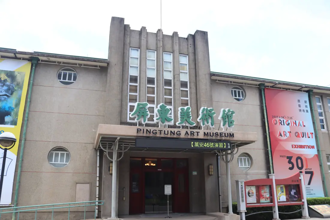
The Pingtung Art Museum is the first municipal art museum established in Taiwan. Here you can enjoy art exhibitions as well as other events. In addition, there is a restored Martial Arts Hall from the Japanese era right next door.
Background: The Pingtung Art Museum was originally the Administrative Office building for Pingtung City, and was completed in 1953. In 2005, the Pingtung City Administrative Building moved to a new location, and the building was used by the Pingtung County Ministry of Culture until it was officially converted into the Pingtung City Art Museum in 2007. In 2012, the art museum was given back to the Pingtung City Administrative Office, meaning that it became the first municipal art museum established in Taiwan. Hours: 9 AM to 5 PM Tuesday to Sunday (closed Mondays) Price: Free Tours and Activities in Pingtung: There are many activities available in Pingtung, such as snorkeling, diving, SUPing, surfing, submarine riding, and river tracing. You can find more tours of Kenting on Klook here or KKday here. Where to stay: Looking for a hotel? Find out where to stay in our Taiwan hotels guide or search for the best hotel deals in Taiwan here. We recommend booking through Agoda here, which provides the best quality selection of accommodation in Taiwan. I have stayed at many hostels and hotels in Pingtung, and even almost bought a house here. Some places that I have stayed at and can recommend are Nanwan Kiki (book on Agoda here, Booking.com here), a B&B next to Nanwan Bay, Kenting's most popular Beach. There are also a few decent hotels near Kenting Street Night Market like Kenting Star Inn 888 (book on Agoda here, Klook here, or Booking.com here), or Kenting Dajianshan Hotel (book on Agoda here or Booking.com here). You will notice that none of these hotels are five star resorts (I do not come to Kenting to waste my time at a resort, but you can still search Agoda, Booking.com, or Klook here for those) but they are in my opinion the above have the best value for the money. How to get there: By Car/Scooter: Take Provincial Highway 1 south to the bottom of Taiwan until it becomes Pingtung City. The Art Museum is on Zhongzheng Road in the middle of the city. Looking for scooter rental in Pingtung? Click here or here to search for options. If you are looking for car rentals, you can also search Qeeq here, Klook here, or KKday here. You can also check out our car rental guide here. By Train: The Art Museum is about a 10 minute walk from Pingtung TRA Station. You can book tickets to Kaohsiung via high speed rail (HSR) on Klook here or KKDay here, or book tickets via the normal train (TRA) on Klook here. You can book tickets to travel to Pingtung via inter-city bus on Klook here. By Bicycle: Cycling is the best way to enjoy Taiwan's landscapes if you have the time and energy. Looking for bicycle rentals in Taiwan? You can search on KKday here and search for tours on Klook here. You can also check out our Taiwan cycling guide here. Map: Please see below: 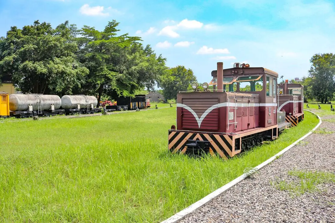
The Pingtung Sugar Factory was one of the largest sugar factories in Taiwan and has now been turned into a museum for the public to visit. The area includes a dessert shop, many old sugar trains, as well as a museum of interesting artifacts from the Taiwan sugar industry heyday. It is definitely worth a visit on your next trip to Pingtung.
Background: The Pingtung Sugar Factory was completed in 1938 during the Japanese Era. At its height, it was processing 3,000 tons of sugar cane per day. After the fall of sugar production in the late 1900s due to the reduction of available land and the growing cost of producing sugar in Taiwan, the factory began to slow production. In 1997, the sugar factory stopped producing sugar, and in 2010 a museum was established on the premises. Because it is only open during business hours on weekdays, usually you will not see many people here. Hours: 8 AM to 12 noon; 1 PM to 4:30 PM Monday to Friday Price: Free Tours and Activities in Pingtung: There are many activities available in Pingtung, such as snorkeling, diving, SUPing, surfing, submarine riding, and river tracing. You can find more tours of Kenting on Klook here or KKday here. Where to stay: Looking for a hotel? Find out where to stay in our Taiwan hotels guide or search for the best hotel deals in Taiwan here. We recommend booking through Agoda here, which provides the best quality selection of accommodation in Taiwan. I have stayed at many hostels and hotels in Pingtung, and even almost bought a house here. Some places that I have stayed at and can recommend are Nanwan Kiki (book on Agoda here, Booking.com here), a B&B next to Nanwan Bay, Kenting's most popular Beach. There are also a few decent hotels near Kenting Street Night Market like Kenting Star Inn 888 (book on Agoda here, Klook here, or Booking.com here), or Kenting Dajianshan Hotel (book on Agoda here or Booking.com here). You will notice that none of these hotels are five star resorts (I do not come to Kenting to waste my time at a resort, but you can still search Agoda, Booking.com, or Klook here for those) but they are in my opinion the above have the best value for the money. How to get there: By Car/Scooter: Take Provincial Highway 1 south to the bottom of Taiwan until it becomes Pingtung City. Ahou Gate is on Zhonghua Road in the middle of the city. Looking for scooter rental in Pingtung? Click here or here to search for options. If you are looking for car rentals, you can also search Qeeq here, Klook here, or KKday here. You can also check out our car rental guide here. By Train: Ahou Gate is about a 10 minute walk from Pingtung TRA Station. You can book tickets to Kaohsiung via high speed rail (HSR) on Klook here or KKDay here, or book tickets via the normal train (TRA) on Klook here. You can book tickets to travel to Pingtung via inter-city bus on Klook here. By Bicycle: Cycling is the best way to enjoy Taiwan's landscapes if you have the time and energy. Looking for bicycle rentals in Taiwan? You can search on KKday here and search for tours on Klook here. You can also check out our Taiwan cycling guide here. Map: Please see below: 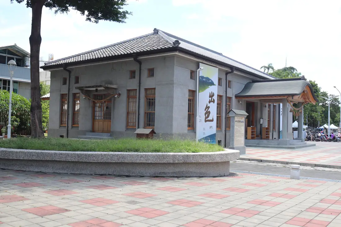
The Pingtung Martial Arts Hall has been recently restored and opened to the public. This building provides a unique glimpse into Taiwan's former Japanese colonial history. In addition, it also has space for art exhibitions. It is definitely worth a stop on your next trip to Pingtung.
Background: The Pingtung Martial Arts Hall was completed in 1929 mainly for the use of local police to practice martial arts. After the KMT took control of Taiwan, this building was used as a military service station. In 2018 the building began restoration work which was completed in 2019. For an overview of Martial Arts History and significance in Taiwan, check out this blog by Josh Ellis. Hours: 9 AM to 5 PM Tuesday to Sunday Price: Free Tours and Activities in Pingtung: There are many activities available in Pingtung, such as snorkeling, diving, SUPing, surfing, submarine riding, and river tracing. You can find more tours of Pingtung on Klook here or KKday here. Where to stay: Looking for a hotel? Find out where to stay in our Taiwan hotels guide or search for the best hotel deals in Taiwan here. We recommend booking through Agoda here, which provides the best quality selection of accommodation in Taiwan. I have stayed at many hostels and hotels in Pingtung, and even almost bought a house here. Some places that I have stayed at and can recommend are Nanwan Kiki (book on Agoda here, Booking.com here), a B&B next to Nanwan Bay, Kenting's most popular Beach. There are also a few decent hotels near Kenting Street Night Market like Kenting Star Inn 888 (book on Agoda here, Klook here, or Booking.com here), or Kenting Dajianshan Hotel (book on Agoda here or Booking.com here). You will notice that none of these hotels are five star resorts (I do not come to Kenting to waste my time at a resort, but you can still search Agoda, Booking.com, or Klook here for those) but they are in my opinion the above have the best value for the money. How to get there: By Car/Scooter: Take provincial highway 1 south to the bottom of Taiwan until it becomes Pingtung City. The Pingtung Martial Arts Hall is on Zhongzheng Road in the middle of the city. Looking for scooter rental in Pingtung? Click here or here to search for options. If you are looking for car rentals, you can also search Qeeq here, Klook here, or KKday here. You can also check out our car rental guide here. By Train: The Martial Arts Hall is about a 10 minute walk from Pingtung TRA Station. You can book tickets to Kaohsiung via high speed rail (HSR) on Klook here or KKDay here, or book tickets via the normal train (TRA) on Klook here. You can book tickets to travel to Pingtung via inter-city bus on Klook here. By Bicycle: Cycling is the best way to enjoy Taiwan's landscapes if you have the time and energy. Looking for bicycle rentals in Taiwan? You can search on KKday here and search for tours on Klook here. You can also check out our Taiwan cycling guide here. Map: Please see below: 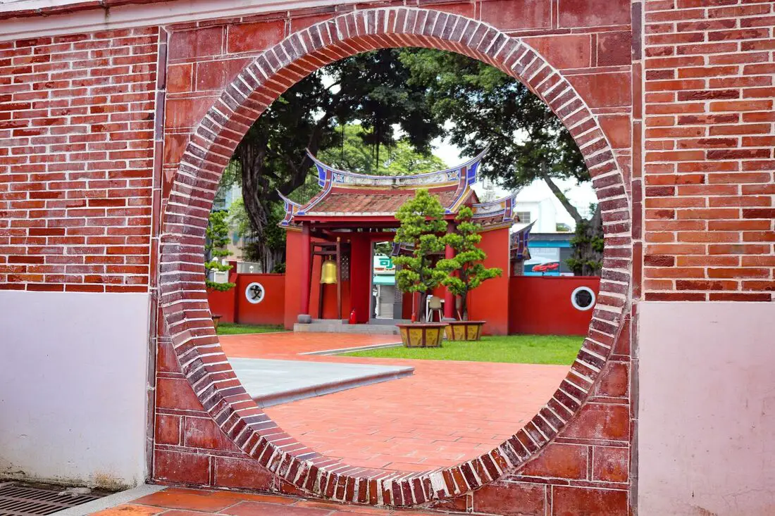
Pingtung Confucius Temple is a former Tutorial Academy dating back to 1815 that was nearly destroyed during the Japanese era but was moved to another location. The temple has also recently been refurbished and is one of the most beautiful historic Confucius Temples in Taiwan. It is definitely worth a visit on your next trip to Pingtung.
Background: For millennia Pingtung had been inhabited by plains aboriginal groups. Their biggest settlement was called Ahou, on the current site of Pingtung City. The first Chinese settlers came to the area in the late 1600s during the Kingdom of Tungming and Qing Dynasty. Before that time, the area was known as a place of exile for Chinese criminals. During the Qing Dynasty, the area was part of Fengshan County. The Pingtung Tutorial Academy was completed in 1815, and its purpose was to provide a place of study for scholars. During the Japanese Era, The City of Pingtung underwent urban planning and the Tutorial Academy was nearly destroyed. The building was originally located near Pingtung Park roughly on the spot of land where Pingtung County Stadium now stands, however under the advice of Gaijiro Fujishima, the building was preserved and moved a few blocks north in 1937. After the start of the Japanese Era, the building was used as a Confucius Temple. Normally there are not many people near the gate and the area is not very busy. Hours: 24/7 Price: Free Tours and Activities in Pingtung: There are many activities available in Pingtung, such as snorkeling, diving, SUPing, surfing, submarine riding, and river tracing. You can find more tours of Kenting on Klook here or KKday here. Where to stay: Looking for a hotel? Find out where to stay in our Taiwan hotels guide or search for the best hotel deals in Taiwan here. We recommend booking through Agoda here, which provides the best quality selection of accommodation in Taiwan. I have stayed at many hostels and hotels in Pingtung, and even almost bought a house here. Some places that I have stayed at and can recommend are Nanwan Kiki (book on Agoda here, Booking.com here), a B&B next to Nanwan Bay, Kenting's most popular Beach. There are also a few decent hotels near Kenting Street Night Market like Kenting Star Inn 888 (book on Agoda here, Klook here, or Booking.com here), or Kenting Dajianshan Hotel (book on Agoda here or Booking.com here). You will notice that none of these hotels are five star resorts (I do not come to Kenting to waste my time at a resort, but you can still search Agoda, Booking.com, or Klook here for those) but they are in my opinion the above have the best value for the money. How to get there: By Car/Scooter: Take Provincial Highway 1 south to the bottom of Taiwan until it becomes Pingtung City. The Confucius Temple is on Shengli Road in the middle of the city. Looking for scooter rental in Pingtung? Click here or here to search for options. If you are looking for car rentals, you can also search Qeeq here, Klook here, or KKday here. You can also check out our car rental guide here. By Train: Pingtung Confucius Temple is about a 10 minute walk from Pingtung TRA Station. You can book tickets to Kaohsiung via high speed rail (HSR) on Klook here or KKDay here, or book tickets via the normal train (TRA) on Klook here. You can book tickets to travel to Pingtung via inter-city bus on Klook here. By Bicycle: Cycling is the best way to enjoy Taiwan's landscapes if you have the time and energy. Looking for bicycle rentals in Taiwan? You can search on KKday here and search for tours on Klook here. You can also check out our Taiwan cycling guide here. Map: Please see below: 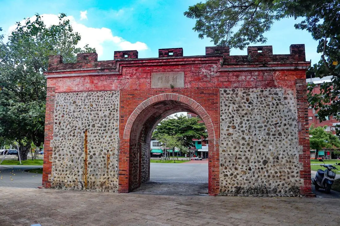
Ahou City Gate (aka Aho City Gate, Aho Gate, East Gate, or Chaoyang Gate) is the last remaining gate from the old walled city of Ahou, which is now Pingtung City. It is one of the last remnants of the walls of the city built nearly 200 years ago during the Qing Dynasty. It is definitely worth a stop on your next trip to Pingtung.
Background: For millennia Pingtung had been inhabited by plains aboriginal groups. Their biggest settlement was called Ahou, on the current site of Pingtung City. The first Chinese settlers came to the area in the late 1600s during the Kingdom of Tungming and Qing Dynasty. Before that time, the area was known as a place of exile for Chinese criminals. During the Qing Dynasty, the area was part of Fengshan County. The city walls began construction in 1836 to defend against robbers, revolts, and infighting between groups of local settlers. Originally there were four city gates built. During the Japanese Era, The City of Pingtung underwent urban planning and most of the walls and gates were destroyed as a result. The last remaining gate is the East Gate, officially called the Chaoyang Gate (朝陽門 Gate facing the sun). It now stands near the Pingtung County Stadium. After an earthquake in 2006, the gate began to sag, after which it underwent restoration work. Normally there are not many people near the gate and the area is not very busy. Hours: 24/7 Price: Free Tours and Activities in Pingtung: There are many activities available in Pingtung, such as snorkeling, diving, SUPing, surfing, submarine riding, and river tracing. You can find more tours of Kenting on Klook here or KKday here. Where to stay: Looking for a hotel? Find out where to stay in our Taiwan hotels guide or search for the best hotel deals in Taiwan here. We recommend booking through Agoda here, which provides the best quality selection of accommodation in Taiwan. I have stayed at many hostels and hotels in Pingtung, and even almost bought a house here. Some places that I have stayed at and can recommend are Nanwan Kiki (book on Agoda here, Booking.com here), a B&B next to Nanwan Bay, Kenting's most popular Beach. There are also a few decent hotels near Kenting Street Night Market like Kenting Star Inn 888 (book on Agoda here, Klook here, or Booking.com here), or Kenting Dajianshan Hotel (book on Agoda here or Booking.com here). You will notice that none of these hotels are five star resorts (I do not come to Kenting to waste my time at a resort, but you can still search Agoda, Booking.com, or Klook here for those) but they are in my opinion the above have the best value for the money. How to get there: By Car/Scooter: Take Provincial Highway 1 south to the bottom of Taiwan until it becomes Pingtung City. Ahou Gate is on Zhonghua Road in the middle of the city. Looking for scooter rental in Pingtung? Click here or here to search for options. If you are looking for car rentals, you can also search Qeeq here, Klook here, or KKday here. You can also check out our car rental guide here. By Train: Ahou Gate is about a 10 minute walk from Pingtung TRA Station. You can book tickets to Kaohsiung via high speed rail (HSR) on Klook here or KKDay here, or book tickets via the normal train (TRA) on Klook here. You can book tickets to travel to Pingtung via inter-city bus on Klook here. By Bicycle: Cycling is the best way to enjoy Taiwan's landscapes if you have the time and energy. Looking for bicycle rentals in Taiwan? You can search on KKday here and search for tours on Klook here. You can also check out our Taiwan cycling guide here. Map: Please see below: 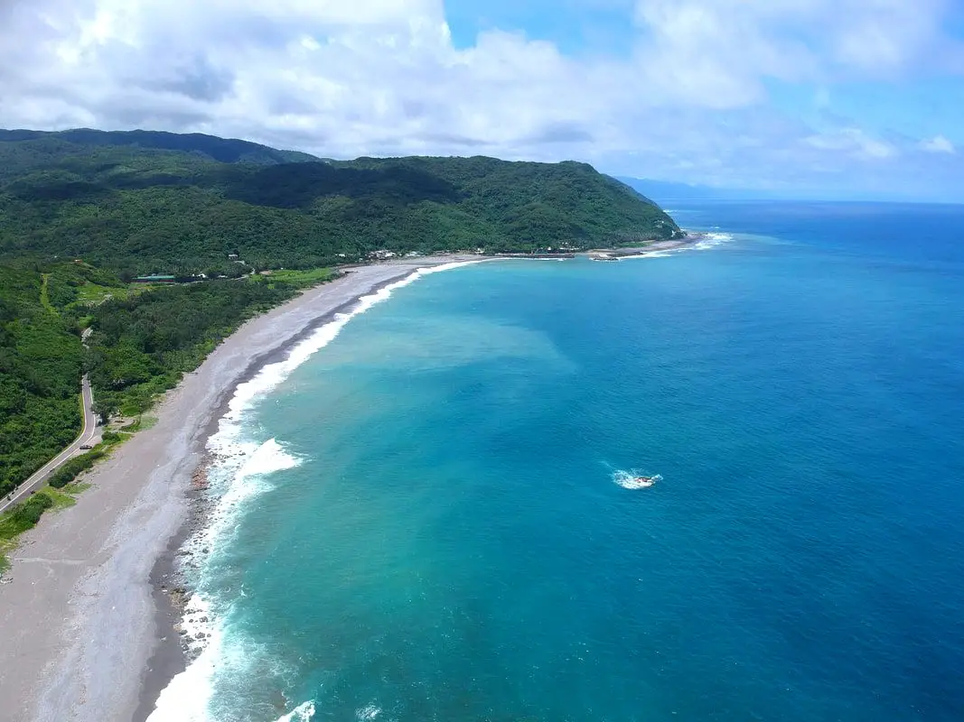
Xuhai Village is a place with amazing coastline in Mudan Township of Pingtung County. Due to its remote location, there are not many people and the landscape is mostly pristine. It may be the most beautiful stretch of coast on the main island of Taiwan.
Background: The area around Xuahi Village was originally named "Mudan Bay" because it is the site of the Mudan Incident in which nearly 100 shipwrecked Japanese sailors were massacred by local Paiwan tribespeople. The first settlers in the area arrived in the early 1900s during the Japanese era, and were mainly aboriginal people and Hakka people from other parts of Taiwan. In 1980 Xuhai Harbor was built to help the local economy and protect ships on the east coast during Typhoons. The population in the area is about half what it was in the 1980s as younger people have moved to big cities for better work opportunities. Even though there are over 450 registered households, only about 120 people regularly live here. Xuhai Village is also the start point of the Alangyi Trail 阿塱壹古道, which connects the east coast here from Pingtung to Taitung. Hours: 24/7 Price: Free Hotels: I have stayed at many hostels and hotels in Kenting, and even almost bought a house here. Some places that I have stayed at and can recommend are Nanwan Kiki (book on Agoda here, Booking.com here), a B&B next to Nanwan Bay, Kenting's most popular Beach. There are also a few decent hotels near Kenting Street Night Market like Kenting Star Inn 888 (book on Agoda here, Klook here, or Booking.com here), or Kenting Dajianshan Hotel (book on Agoda here or Booking.com here). You will notice that none of these hotels are five star resorts (I do not come to Kenting to waste my time at a resort, but you can still search Agoda or Booking.com) but they are in my opinion the above have the best value for the money. Looking for a hotel? Find out where to stay in our Taiwan hotels guide or search for the best hotel deals in Taiwan here. We recommend booking through Agoda here, which provides the best quality selection of accommodation in Taiwan. Tours and Activities in Pingtung: There are many activities available in Kenting, such as snorkeling, diving, SUPing, surfing, submarine riding, and river tracing. You can find more tours of Kenting on Klook here or KKday here. How to get there: By Bus: You can take bus 304 or 304A to Gangzai Nei station, and the sand dunes are about a half hour walk away. You can book tickets to travel to Pingtung via inter-city bus on Klook here. By Car/Scooter: Take County Highway 200 to Jiupeng in Pingtung. The sand dunes are very big and obvious along the coast. Looking for scooter rental in Pingtung? Click here or here to search for options. If you are looking for car rentals, you can also search here. By Bicycle: Cycling is the best way to enjoy Taiwan's landscapes if you have the time and energy. Looking for bicycle rentals in Taiwan? You can search on KKday here and search for tours on Klook here. You can also check out our Taiwan cycling guide here. Map: See below: 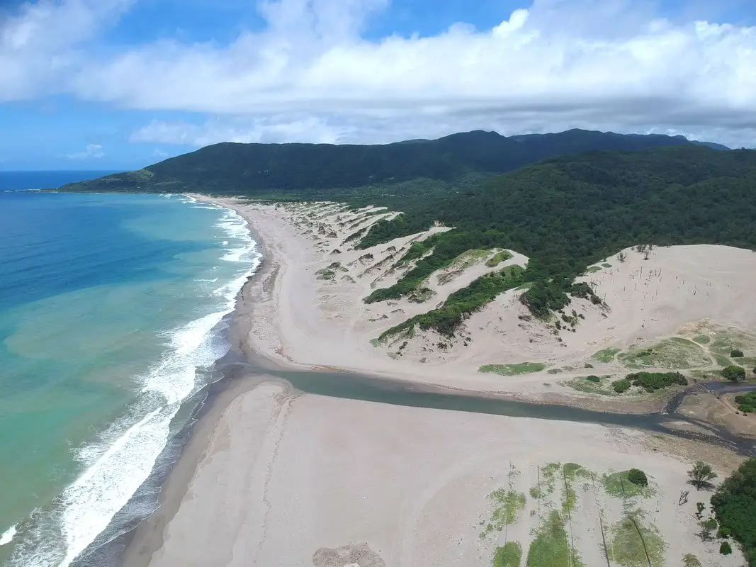
The Jiupeng Desert (aka Jioupeng Desert 九棚大沙漠 or Gangzhi Desert 港仔大沙漠) is a row of sand dunes along the coastline near Jiupeng Village, Manzhou Township, Pingtung County, and are the largest sand dunes in Taiwan. The area is not actually a desert but is formed from strong northeast winds along the coast, creating large dunes of sand despite the fact that Taiwan is a wet, tropical island.
Background: The area around Jiupeng Village was named because of nine villages in the area. The first settlers in the area arrived in the early 1900s during the Japanese era. The population in the area is about half what it was in the 1980s as younger people have moved to big cities for better work opportunities. Even though there are over 300 registered households, only about 100 people regularly live here. The sand dunes have become a popular spot for ATVing and off-roading, however some accidents and liability issues have hampered the industry. Usually you will not see many people here because the area is so remote. Hours: 24/7 Price: Free Where to stay: Looking for a hotel? Find out where to stay in our Taiwan hotels guide or search for the best hotel deals in Taiwan here. We recommend booking through Agoda here, which provides the best quality selection of accommodation in Taiwan. I have stayed at many hostels and hotels in Pingtung, and even almost bought a house here. Some places that I have stayed at and can recommend are Nanwan Kiki (book on Agoda here, Booking.com here), a B&B next to Nanwan Bay, Kenting's most popular Beach. There are also a few decent hotels near Kenting Street Night Market like Kenting Star Inn 888 (book on Agoda here, Klook here, or Booking.com here), or Kenting Dajianshan Hotel (book on Agoda here or Booking.com here). You will notice that none of these hotels are five star resorts (I do not come to Kenting to waste my time at a resort, but you can still search Agoda, Booking.com, or Klook here for those) but they are in my opinion the above have the best value for the money. Tours and Activities in Pingtung: There are many activities available in Kenting, such as Riding ATVs (four wheeling) on the beach snorkeling, diving, SUPing, surfing, submarine riding, and river tracing. You can find more tours of Kenting on Klook here or KKday here. How to get there: By Bus: You can take bus 304 or 304A to Gangzai Nei station, and the sand dunes are about a half hour walk away. You can book tickets to travel to Pingtung via inter-city bus on Klook here. By Car/Scooter: Take County Highway 200 to Jiupeng in Pingtung. The sand dunes are very big and obvious along the coast. Looking for scooter rental in Pingtung? Click here or here to search for options. If you are looking for car rentals, you can also search Qeeq here, Klook here, or KKday here. You can also check out our car rental guide here. By Bicycle: Cycling is the best way to enjoy Taiwan's landscapes if you have the time and energy. Looking for bicycle rentals in Taiwan? You can search on KKday here and search for tours on Klook here. You can also check out our Taiwan cycling guide here. Map: See below: 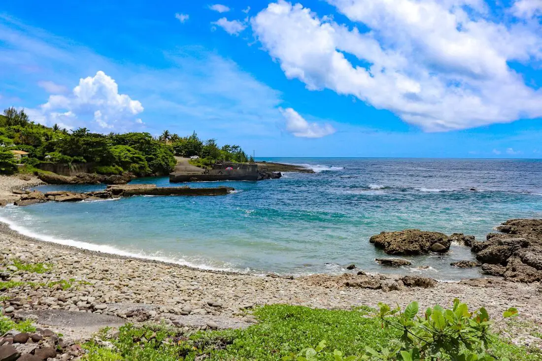
Nanren Fishing Harbor is known as the loneliest fishing harbor in Taiwan. It lies at the dead end of Nanren Road at the northern end of Kenting National Park, the end of the road along the east coast between it and Jialeshui. Here you can find pristine landscapes, an amazing shoreline, and more cows than people.
Background: The area around Jiupeng Village was named because of nine villages in the area. The first settlers in the area arrived in the early 1900s during the Japanese era. The population in the area is about half what it was in the 1980s as younger people have moved to big cities for better work opportunities. Even though there are over 300 registered households, only about 100 people regularly live here. Nanren Fishing Harbor currently lies in the northeast part of Kenting National Park, as part of the Nanren Nature Preserve, which includes Nanren Lake, a remote wetland area in the mountains of Nanren. Hours: 24/7 Price: Free Where to stay: Looking for a hotel? Find out where to stay in our Taiwan hotels guide or search for the best hotel deals in Taiwan here. We recommend booking through Agoda here, which provides the best quality selection of accommodation in Taiwan. I have stayed at many hostels and hotels in Pingtung, and even almost bought a house here. Some places that I have stayed at and can recommend are Nanwan Kiki (book on Agoda here, Booking.com here), a B&B next to Nanwan Bay, Kenting's most popular Beach. There are also a few decent hotels near Kenting Street Night Market like Kenting Star Inn 888 (book on Agoda here, Klook here, or Booking.com here), or Kenting Dajianshan Hotel (book on Agoda here or Booking.com here). You will notice that none of these hotels are five star resorts (I do not come to Kenting to waste my time at a resort, but you can still search Agoda, Booking.com, or Klook here for those) but they are in my opinion the above have the best value for the money. Tours and Activities in Pingtung: There are many activities available in Kenting, such as snorkeling, diving, SUPing, surfing, submarine riding, and river tracing. You can find more tours of Kenting on Klook here or KKday here. How to get there: By Bus: The nearest bus stop is at Jiupeng Village via bus 304A, and it is about an hour walk (5KM) to the fishing harbor. You can book tickets to travel to Pingtung via inter-city bus on Klook here. By Car/Scooter: Take Couny Highway 200 to Jiupeng in Pingtung, then turn right onto Nanren Road. The fishing harbor is at the very end of the road. Looking for scooter rental in Pingtung? Click here or here to search for options. If you are looking for car rentals, you can also search Qeeq here, Klook here, or KKday here. You can also check out our car rental guide here. By Bicycle: Cycling is the best way to enjoy Taiwan's landscapes if you have the time and energy. Looking for bicycle rentals in Taiwan? You can search on KKday here and search for tours on Klook here. You can also check out our Taiwan cycling guide here. Map: See below: 
The Gaoping Old Iron Bridge (aka Lower Tamsui River Iron Bridge 下淡水溪鐵橋) is a disused railway bridge across the Gaoping River, formerly connecting Kaohsiung to Pingtung. The bridge was retired in 1987 in favor of a new electrified bridge, and the center section of the bridge was washed away during Typhoon Haitang in 2005. At the time of construction, it was the longest bridge in Asia and the first overland pathway created between Kaohsiung and Pintung. Originally planned to be torn down, it was saved by concerned residents on both sides of the river and now stands as a monument to the past.
Background: The Gaoping Old Iron bridge began construction in 1910 and was completed in 1913. A rail link was needed to ship sugar cane and related products from Pingtung to Kaohsiung Harbor. During the Japanese era, the Gaoping River was known as the lower Tamsui River, hence the name of the bridge was the Lower Tamsui River Iron Bridge. Due to the river's wide banks and strong current, it was a great engineering feat of its time. Along the way many floods halted and destroyed construction. Two months after construction was complete, the railway from Kaohsiung to Pingtung was officially opened. The bridge was 1,526 meters long, 7 meters wide, with trusses 15 meters high. At the time of construction, it was the longest bridge in Asia and the first overland pathway created between Kaohsiung and Pintung. The current trusses on the bridge were built in 1964, to replace the corroding old trusses from the Japanese era. The bridge was retired in 1987 in favor of a new electrified bridge with two tracks as part of the electrification of Taiwan's railway. The bridge was officially retired in 1992. Originally planned to be torn down, it was saved by concerned residents on both sides of the river and was named a national historic monument in 1997. The center section of the bridge was washed away during Typhoon Haitang in 2005, washing out the No. 9, 10, and 11 pillars. No. 12 and 14 pillars were also wiped out in a Typhoon in 2006, and another fell in 2008. In 2018 the wooden cross beams were replaced, which had begun to rot. Currently there are parks on both sides of the river commemorating the bridge, with more people visiting the Kaohsiung side due to its proximity to down town Dashu. Price: Free Hours: 24/7 How to get there: By Car/Scooter: Take provincial highway 29 north to Dashu. Stop when the road goes underneath the railroad. There is plenty of parking nearby. You can also cross the provincial highway 1 bridge to Pingtung and drive to the park on the other side of the bridge. Looking for scooter rental in Kaohsiung? You can check out Klook here or KKday here to search for options. You can check also out our scooter rental guide here. If you are looking for car rentals, you can search Qeeq here, KKday here, or Klook here. You can also check out our car rental guide here. By Train: Take the TRA to Jiuqutang Station. The park is about a five minute walk away. You can also take the TRA to Liukuaicuo Station and walk back west to the park on the east side, but it is about a 3 KM walk. You can book tickets to travel to Kaohsiung via inter-city bus on Klook here. You can book tickets to Kaohsiung via high speed rail (HSR) on Klook here or KKDay here. Book tickets via the normal train (TRA) on Klook here. You can also book a Kaohsiung Travel pass here. Accommodation We have stayed at and recommend Chao She Hotel (you can book on Agoda here, Booking.com here, Hotels.com here, or Expedia here) IHI Sanduo Travel Hotel (you can book on Agoda here, Booking.com here, Hotels.com here, or Expedia here), and Mingli Hotel (you can book on Agoda here, Klook here, or Hotels.com here) which are three inexpensive and high quality choices in downtown Kaohsiung. I also have stayed at and recommend Kaohsiung Meinong Rabbit Paul Homestay B&B (you can book on Agoda here, Booking.com here, or Trip.com here), a quiet B&B in rural Meinong, and Chengching Lakeside Resort (you can book on Agoda here, Booking.com or Trip.com here)and the Grand Hotel Kaohsiung (you can book on Agoda here, Booking.com here, Hotels.com here, or Expedia here) which both offer breakfast buffet and free entrance into Chenqing Lake Park. I have also stayed at the 85 sky tower which offers great views of the city; you can search for rooms in the 85 sky tower on Agoda here, Booking.com here, Hotels.com here, Expedia here, or Trip.com here). Find out more about where to stay in our Taiwan hotels guide or search for the best hotel deals in Taiwan here. We recommend booking through Agoda here, which provides the best quality selection of accommodation on the islands. You can also book Wifi and SIM cards for Taiwan on Gigago here. Need travel insurance? Compare prices on Insubuy here. Tours: You can find more tours and activities in Kaohsiung such as Pier 2, Meinong Hakka Museum, Hamasen Railway Museum, Suzuka Circuit Park, i-Ride Kaohsiung Visual 5D Flying Theater, National Science and Technology Museum , Senya Village Restaruant, Austin Land, Ski School Indoor Ski Slope, and many more on Klook here or KKday here. Just to let you know, if you book using the links above, we get some commission at no cost to you, and you can help support our blog. You can click here to receive $5 USD on your first Klook purchase. Map: Please see below: 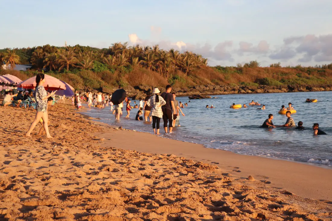
Baishawan Beach in Kenting (aka White Sand Bay, not to be confused with Baishawan Beach in New Taipei) is arguably the best beach in Taiwan, with excellent sand, warm clear water, warm temperatures year-round, and fewer visitors than Nanwan Beach.
Background: Kenting was first settled by Chinese farmers during the Qing Dynasty. The word Kenting comes from two words that mean cultivate (ken3 墾) and strong man (丁 ding1). During that time, a group of strong men (or Zhuang Ding 壯丁) came from Guangdong, who were basically Chinese pioneers of the area to cultivate the land, hence the area was named Kenting for them. The area was considered to be made into a park during the Japanese occupation due to it being the only tropical location in the Japanese Empire but was never officially created. Kenting National Park was established in 1984 as the first national park in Taiwan after WWII. Kenting became a major vacation spot, becoming a center for hostels and hotels for travelers. Kenting is considered by many to have the best beaches in Taiwan. This is because of its fine white sand and year-round warm temperatures and sunshine (it is in the tropical part of Taiwan after all). Baishawan Beach was a filming location for Life of Pi, acting as the tropical Mexican shoreline. Baishawan Beach was also named the "Best Kept Secret" beach in the world by BeachTomato.com. Hours: 24/7 Price: Free When to go: Summer! It's when the water is warmest and the sun is hottest. However there will be more people in summer, and there could be Typhoons. Spring and Fall are also good times to go, as there will be fewer visitors and cooler temperatures. Winter is an okay time to go as well, it will be warmer than the rest of Taiwan and the water will still be warm enough to swim in. How to get there: By Car/Scooter: Take provincial highway 1 south to the bottom of Taiwan until it becomes provincial highway 26. After you pass Hengchun, take a right onto Longguang Road and keep going west toward the sea. The beach will be on your right as you travel south on county road 153. Looking for scooter rental in Kenting? Click here or here to search for options. You can also check out our Taiwan scooter rental guide here. If you are looking for car rentals, you can also search here. You can also check out our car rental guide here. By Bus: Busses leave daily to Kenting from Zuoying HSR station, Kaohsiung Station, and Pingtung. Get off at the Hengchun Bus Station, and then take the 305 Hengchun Bus to the White Sand Bay stop. You can book tickets to Pingtung via high speed rail (HSR) on Klook here or KKDay here, or book tickets via the normal train (TRA) on Klook here. You can book tickets to travel to Pingtung via inter-city bus on Klook here. By Plane: There are direct shuttle buses to Kenting from Kaohsing's Xiaogang (KHH) Airport. You can book cheap flights to Kinmen on Trip.com or CheapO Air. You can also search for cheap flights in Taiwan on Kiwi here. Accommodation: I have stayed at many hostels and hotels in Kenting, and even almost bought a house here. Some places that I have stayed at and can recommend are Nanwan Kiki (book on Agoda here, Booking.com here), a B&B next to Nanwan Bay, Kenting's most popular Beach. There are also a few decent hotels near Kenting Street Night Market like Kenting Star Inn 888 (book on Agoda here, Klook here, Hotels.com here, Expedia here, or Booking.com here), or Kenting Dajianshan Hotel (book on Agoda here, Booking.com here, Hotels.com here, or Expedia here). You will notice that none of these hotels are five star resorts (I do not come to Kenting to waste my time at a resort, but you can still search Agoda, Booking.com, Hotels.com, or Expedia for those) but they are in my opinion the above have the best value for the money. Looking for a hotel? Find out where to stay in our Taiwan hotels guide or search for the best hotel deals in Taiwan here. We recommend booking through Agoda here, which provides the best quality selection of accommodation in Taiwan. You can also book Wifi and SIM cards for Taiwan on Gigago here. Need travel insurance? Compare prices on Insubuy here. Tours and Activities in Kenting: There are many activities available such as snorkeling, diving, SUPing, surfing, submarine riding, and river tracing. You can find more tours of Kenting on Klook here or KKday here. Just to let you know, if you book using the links above, we get some commission at no cost to you, and you can help support our blog. You can click here to receive $5 USD on your first Klook purchase. Map: Please see below: 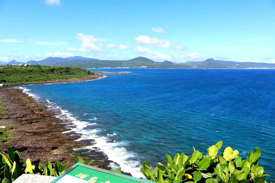
Maobitou Park is a coral and limestone cliff area with viewing platform that offers amazing panoramic views of the Hengchun Peninsula. There are also many interesting rock formations such as a rock that looks like a cat, as well as plants and wildlife. You should definitely stop by on your next trip to Kenting.
Background: Maobitou is the dividing line between the Taiwan Strait and the Bashi Channel in the Pacific Ocean. There is one prominent rock here that looked like a cat to local residents, hence the name of the area Maobitou 貓鼻頭, literally meaning cat rock. After uplift of the Eurasian Plate due to Collision with the Pacific plate, the rocks here have been thrust up from the sea over thousands of years. Now that they are exposed to wind and rain, the rocks here have taken on odd shapes and made giant holes and crevices. The water between Maobitou and Houshanbi Harbor is clear and full of sea life, and is one of the most diverse environments in Taiwan. Kenting was first settled by Chinese during the Qing Dynasty. The word Kenting comes from two words that mean cultivate (ken3 墾) and strong man (丁 ding1). During that time, a group of strong men (or Zhuang Ding 壯丁) came from Guangdong, who were basically Chinese pioneers of the area to cultivate the land, hence the area was named Kenting for them. The area was considered to be made into a park during the Japanese occupation due to it being the only tropical location in the Japanese Empire, but was never officially created. Kenting National Park was established in 1984 as the first national park in Taiwan after WWII. Kenting became a major vacation spot, becoming a center for hostels and hotels for travelers. Kenting is considered by many to have the best beaches in Taiwan. This is because of its fine white sand and year-round warm temperatures and sunshine (it is in the tropical part of Taiwan after all). Hours: 8 AM to 5 PM Price: 30 NT per person Parking: 40 NT for cars or 10 NT for scooters. When to go: Summer! It's when the water is warmest and the sun is hottest. However there will be more people in summer, and there could be Typhoons. Spring and Fall are also good times to go, as there will be less visitors and cooler temperatures. Winter is an okay time to go as well, it will be warmer than the rest of Taiwan and the water will still be warm enough to swim in. How to get there: By Car/Scooter: Take provincial highway 1 south to the bottom of Taiwan until it becomes provincial highway 26. After that turn right on highway 153 and keep left until you see the signs to Maobutou. Looking for scooter rental in Kenting? Click here or here to search for options. You can also check out our Taiwan scooter rental guide here. If you are looking for car rentals, you can also search here. You can also check out our car rental guide here. By Bus: Busses leave daily to Kenting from Zuoying HSR station, Kaohsiung Station, and Pingtung. From Hengchun Bus Station, you can take shuttle bus 102 to Maobitou Bus Stop. You can book tickets to Pingtung via high speed rail (HSR) on Klook here or KKDay here, or book tickets via the normal train (TRA) on Klook here. You can book tickets to travel to Pingtung via inter-city bus on Klook here. Accommodation: I have stayed at many hostels and hotels in Kenting, and even almost bought a house here. Some places that I have stayed at and can recommend are Nanwan Kiki (book on Agoda here, Booking.com here), a B&B next to Nanwan Bay, Kenting's most popular Beach. There are also a few decent hotels near Kenting Street Night Market like Kenting Star Inn 888 (book on Agoda here, Klook here, Hotels.com here, Expedia here, or Booking.com here), or Kenting Dajianshan Hotel (book on Agoda here, Booking.com here, Hotels.com here, or Expedia here). You will notice that none of these hotels are five star resorts (I do not come to Kenting to waste my time at a resort, but you can still search Agoda, Booking.com, Hotels.com, or Expedia for those) but they are in my opinion the above have the best value for the money. Looking for a hotel? Find out where to stay in our Taiwan hotels guide or search for the best hotel deals in Taiwan here. We recommend booking through Agoda here, which provides the best quality selection of accommodation in Taiwan. You can also book Wifi and SIM cards for Taiwan on Gigago here. Need travel insurance? Compare prices on Insubuy here. Tours and Activities in Kenting: There are many activities available such as snorkeling, diving, SUPing, surfing, submarine riding, and river tracing. You can find more tours of Kenting on Klook here or KKday here. Just to let you know, if you book using the links above, we get some commission at no cost to you, and you can help support our blog. You can click here to receive $5 USD on your first Klook purchase. Map: Please see below: 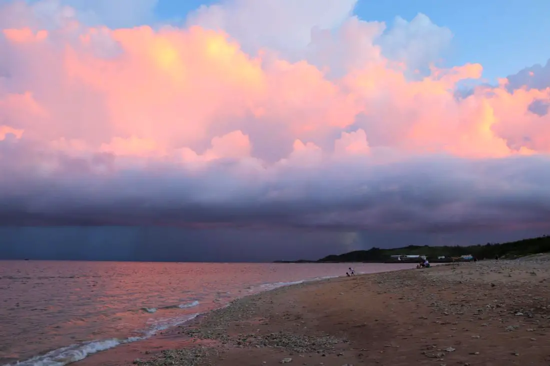
Houbihu Beach (aka Zhongzhou Beach or Daguang Beach) is a long coral beach between Houbihu Harbor and the No. 3 Nuclear plant in Taiwan. It features shallow water and great snorkeling. Also due to its location and lack of facilities there are usually not many people here.
Background: Houbihu beach was originally closed to the public until recently. Now that it has opened up, it has become a popular location for snorkeling, surfing, and using SUPs. There are no bathrooms or showers at the beach. Kenting was first settled by Chinese during the Qing Dynasty. The word Kenting comes from two words that mean cultivate (ken3 墾) and strong man (丁 ding1). During that time, a group of strong men (or Zhuang Ding 壯丁) came from Guangdong, who were basically Chinese pioneers of the area to cultivate the land, hence the area was named Kenting for them. The area was considered to be made into a park during the Japanese occupation due to it being the only tropical location in the Japanese Empire, but was never officially created. Kenting National Park was established in 1984 as the first national park in Taiwan after WWII. Kenting became a major vacation spot, becoming a center for hostels and hotels for travelers. Kenting is considered by many to have the best beaches in Taiwan. This is because of its fine white sand and year-round warm temperatures and sunshine (it is in the tropical part of Taiwan after all). Hours: 24/7 Price: Free When to go: Summer! It's when the water is warmest and the sun is hottest. However there will be more people in summer, and there could be Typhoons. Spring and Fall are also good times to go, as there will be less visitors and cooler temperatures. Winter is an okay time to go as well, it will be warmer than the rest of Taiwan and the water will still be warm enough to swim in. How to get there: By Car/Scooter: Take provincial highway 1 south to the bottom of Taiwan until it becomes provincial highway 26. After you pass Hengchun, take a right onto Longguang Road and keep left toward Houbihu Harbor. The beach is to the north of the fishing harbor. There is free parking on the side of the road. Looking for scooter rental in Pingtung? Click here or here to search for options. You can also check out our Taiwan scooter rental guide here. If you are looking for car rentals, you can also search here. You can check out our car rental guide here. By Bus: Busses leave daily to Kenting from Zuoying HSR station, Kaohsiung Station, and Pingtung. Get off at the Hengchun Bus Station, and then take the 102 shuttle Bus to the Houbihu stop and walk about 15 minutes to the beach. You can book tickets to Pingtung via high speed rail (HSR) on Klook here or KKDay here, or book tickets via the normal train (TRA) on Klook here. You can book tickets to travel to Pingtung via inter-city bus on Klook here. By Plane: There are direct shuttle busses to Kenting from Kaohsiung's Xiaogang (KHH) Airport. Accommodation: I have stayed at many hostels and hotels in Kenting, and even almost bought a house here. Some places that I have stayed at and can recommend are Nanwan Kiki (book on Agoda here, Booking.com here), a B&B next to Nanwan Bay, Kenting's most popular Beach. There are also a few decent hotels near Kenting Street Night Market like Kenting Star Inn 888 (book on Agoda here, Klook here, Hotels.com here, Expedia here, or Booking.com here), or Kenting Dajianshan Hotel (book on Agoda here, Booking.com here, Hotels.com here, or Expedia here). You will notice that none of these hotels are five star resorts (I do not come to Kenting to waste my time at a resort, but you can still search Agoda, Booking.com, Hotels.com, or Expedia for those) but they are in my opinion the above have the best value for the money. Looking for a hotel? Find out where to stay in our Taiwan hotels guide or search for the best hotel deals in Taiwan here. We recommend booking through Agoda here, which provides the best quality selection of accommodation in Taiwan. You can also book Wifi and SIM cards for Taiwan on Gigago here. Need travel insurance? Compare prices on Insubuy here. Tours and Activities in Kenting: There are many activities available such as snorkeling, diving, SUPing, surfing, submarine riding, and river tracing. You can find more tours of Kenting on Klook here or KKday here. Just to let you know, if you book using the links above, we get some commission at no cost to you, and you can help support our blog. You can click here to receive $5 USD on your first Klook purchase. Map: Please see below: |
Author 作家I am an American expat who has extensive experience living, working, and traveling in Taiwan. In my day, I had to learn many things about Taiwan the hard way. But I have come to learn that Taiwan is one of the best places in the world for Foreigners to live. This blog does not represent the opinions of every foreigner in Taiwan. I am just trying to help others learn more about this beautiful country. Categories
|
 RSS Feed
