

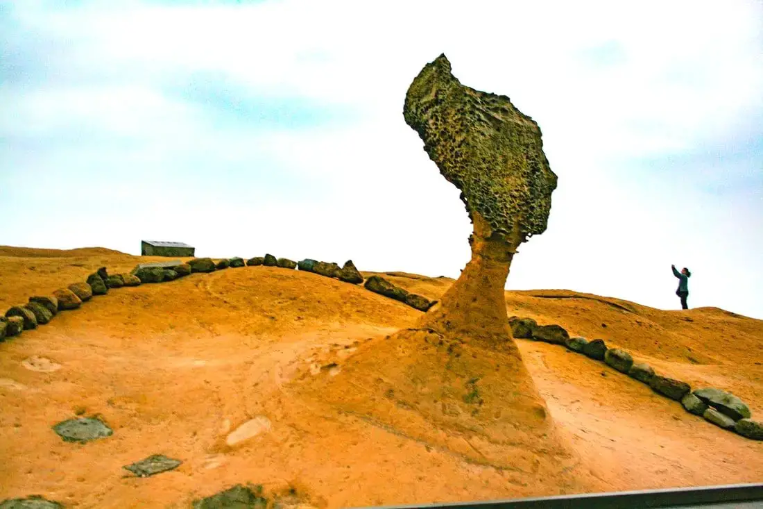
Yehliu is perhaps the most famous geological park in Taiwan, with its most famous landmark being the Queen's Head rock. These rock formations have been forming for thousands of years through erosion of soft sandstone due to wind and water. Hurry and see these formations soon before they are gone forever!
Background: The sandstone that forms the Yehliu formation was created between 10 and 20 million years ago, and was pushed out of the sea along with northern Taiwan thousands of years ago. The Queen's head is formed by two layers of sandstone, one soft fast eroding layer on bottom and a harder layer on top. This kind of sandstone formation can be seen around the world and is known as a hoodoo. The Queen's head was named after Queen Elizabeth I, because it is thought to look like her. The head is eroding .2 to .5 CM per year and is expected to fall at any time! The name Yehliu comes from the Spanish name for the area "Putno Diablos" which was then also used by the Dutch, and transliterated by the Chinese settlers in the area as "Yehliu" in Chinese. Yehliu Ocean world is the largest aquarium in northern Taiwan and has one of the few outdoor sea life amphitheaters in Taiwan. The facility features an indoor aquarium and outdoor show that is geared toward children. Hours: Yehliu Geopark: 8 AM to 5 PM in winter (tickets not sold after 4:30) 8 AM to 6 PM in summer (tickets not sold after 5:30) Yehliu Ocean World: 9 AM to 5 PM Price: Yehliu Geopark: 120 NT per person. You can book discount tickets to Yehliu Geopark on Klook here and KKday here. Yehliu Ocean World: 450 NT per person. You can book discount tickets to Yehliu Ocean World on Klook here and KKday here. You can also book tickets to the Yehliu Ocean World Parent-Child playground on Klook here. Tours: You can book a tour to Yehliu on TripAdvisor here, Klook here, or KKday here. Can I touch the rocks? Don't you dare touch the rocks! Activities along Taiwan's Northern Coast: Don't forget that there are many activities available along Taiwan's Northern Coast such as Wakeboarding, Surfing, Speedboat Surfing, SUP / Paddle Boarding, Diving, Snorkeling Kayaking, Canoeing, Water Biking, River Tracing / Canyoneering, ATVing, Horse Riding, Archery, Tree Climbing, Glamping, Motorcycling, Motorbike Tour, Dragon Boat Racing, Shen'ao Rail Bike, and more on Tripadvisor here, Klook here, or KKday here. Hotels on Taiwan's Northern Coast: We recommend Fullon Hotel which has locations in Tamsui and Fulong near the beach (book on Booking.com here, Tripadvisor here, Agoda here, or Hotels.com here). We have stayed at and recommend Gold Mountain Ranch, which is a horse ranch and glamping destination in Jinshan. You can book a night at Gold Mountain Ranch on Klook here. You can also check out our full blog on the ranch here. We have also stayed at and recommend Hai Xia Your Home which is right in front of Fulong Beach (book on Booking.com here, Tripadvisor here, Agoda here, or Hotels.com here). Looking for a hotel? We recommend booking through Booking.com here, which provides the best quality selection of accommodation in Taiwan. Find out where to stay in our Taiwan hotels guide or search for the best hotel deals in Taiwan here. How to get there: By Bus: There are inter-city buses that leave hourly from Taipei Main Station and Taipei City Hall to Yehliu. You can purchase a discount easy card to use on the MRT and buses from Klook here or KKday here. You can also book an MRT travel pass on Klook here. By Car/Scooter: Take Provincial highway 2 west out of Keelung, and keep going until you reach Wanli. The turnoff to Yehliu comes right after Wanli beach. If you are looking for car rentals, you can also search Qeeq here, Klook here, or KKday here. You can also check out our car rental guide here. Looking for scooter rental in northern Taiwan? You can search on Klook here or KKday here to search for options. You can also check out our scooter rental guide here. By Bicycle: Cycling is the best way to enjoy Taiwan's landscapes if you have the time and energy. Looking for bicycle rentals in Taiwan? You can use Taiwan's many Youbike sharing stations, or search for rentals on KKday here, and search for tours on Klook here. You can also check out our Taiwan cycling guide here. You can also book a cycling tour on TripAdvisor here. For more information, check out our Taiwan transportation guide here. Map: Please see below:
0 Comments

The Dragon Boat Festival (aka Double Fifth Festival) is a special time of year, during which Taiwan gets a major holiday vacation and there are Dragon Boat Races. During this time, people also must eat Zongzi. We have created this guide for you to see the official dragon boat races all around Taiwan and understand more about this special cultural festival.
Historical Background: Originally Dragon Boat Festival may have started during the Qin Dynasty as a day to remove evil spirits and bad luck that were thought to appear on the fifth day of the fifth month. The best known origin story for the Dragon Boat Festival is that it commemorates the death of Qu Yuan, a famous poet and official of the Chu Dynasty during the Warring States Period. He opposed the Chu Dynasty joining an alliance with the Qin, and therefore was banished. When the Qin Dynasty finally took over the Chu Dynasty, he committed suicide by entering the Miluo River (汨羅江 Mìluójiāng) and drowning himself. It was said that the local people went looking for him by rowing dragon shaped canoes, and threw sticky rice balls into the water so that the fish would eat the rice and not Qu Yuan's body. Because of this, during Dragon Boat Festival everyone eats stick rice, or Zongzi, and holds dragon boat races to commemorate Qu Yuan's memory. Another tradition is for people to balance eggs, which is thought to bring good luck during the "unlucky" holiday. Dragon Boat races usually involve a team rowing together, while someone beats a drum to keep rhythm and someone else stands at the front of the boat to catch the flag. Dragon Boat Festival is an official holiday in Taiwan, Hong Kong, Macau, China, and is celebrated by Chinese heritage communities throughout Asia and the world. When is Dragon Boat Festival? The fifth day of the fifth month of the lunar calendar. 2025: May 31st (national holiday starts May 30th) 2025: June 19th 2026: June 9th Can I go Dragon Boat Racing in Taiwan? Yes! You can join this Dragon Boat tour on Klook or this one on KKday any time of year. The cost is about 1300 NT per person. When are Dragon Boat Races in Taiwan? Training starts about a month before Dragon Boat Festival. The actual races begin a few days before or on Dragon Boat Festival, and can last a few days after as well. Races usually start at about 9 or 10 AM and last the whole day (some will end in the afternoon, some will have races at night). Where are the 2025 Dragon Boat Races in Taiwan? Taipei International Dragon Boat Championships: 台北國際龍舟錦標賽 Dates: (June 8-June 10 2024) Location: Dajia Riverside Park 大佳河濱公園 (under Dazhi Bridge going to Neihu near the airport along the Keelung River. There is parking at the riverside park, but it can get very crowded late in the day). New Taipei Dragon Boat Race 新北市龍舟錦標賽 Dates: (June 9-10 2024) Location: Luzhou Breeze Park 微風運河水域 Keelung Dragon Boat Festival 基隆龍舟競賽 Date: (June 9-10 2024) Held at Badouzi Harbor 八斗子漁港 Longtan Dragon Boat Races: June 8th-10th 2024 Held at Longtan Lake 龍潭大池 Hsinchu County Dragon Boat Festival 新竹縣縣長盃龍舟競賽 Dates: (June 10 2024) Held at No. 93 Xinshi Road Hsinfeng Township. 新豐鄉新市路九十三號 Miaoli Dragon Boat Races 苗栗龍舟賽 Dates: (June 10 2024) Held at dragon boat ferry dock along the Zhonggang River in Zhunan. 竹南鎮港墘里中港溪畔的龍舟碼頭 Changhua Lukang Night Boat Races 鹿港夜間龍舟賽 Date: (June 8-10 2024) Location: Lukang, along the FuLu River near Lukang Old Street (彰化福鹿溪水域) Yunlin Dragon Boat Races 雲林龍舟賽 Dates: (closed in 2024 until further notice) Location: Kouhu Township, Yiwu Wet Pond at the north pond (本縣口湖鄉宜梧滯洪池北池) Chiayi Dragon Boat Races 嘉義龍舟比賽 Date: (June 10 2024) Location: Dongshi Harbor 東石漁港 Tainan International Dragon Boat Championships: 台南市國際龍舟賽 Dates: (June 6-June 10 2024) Location: Yunhe River in Tainan Between Anyi Bridge and Chengtian Bridge, near Anping Old Street 臺南市運河(安億橋至承天橋河段) Kaohsiung Love River Dragon Boat Festival: 高雄愛河端午龍舟嘉年華 Dates: (June 8-June 10 2024) Location: The Love River between Kaohsiung Bridge and Zhongzheng Bridge (愛河, 高雄橋-中正橋). Pingtung County Dragon Boat Race 屏東縣端午龍舟競賽 Dates: (June 9-10 2024) Location: Underneath Donggang Great Bridge in Donggang (東港大橋). Yilan County Dragon Boat Race 宜蘭縣端午龍舟競賽 Dates: (June 10 2024) Location: Dongshan River Yicheng Bridge 冬山河義城橋 Hualien County Dragon Boat Race 花蓮縣端午龍舟競賽 Dates: (June 10 2024) Location: TBA (last year it was Liyu Lake 鯉魚潭) Penghu County Dragon Boat Festival 澎湖縣龍舟競賽 Dates: (June 10 2024) Location: Makung No. 3 Harbor (澎湖縣馬公第3漁港). Kinmen County Dragon Boat Festival 金門縣龍舟競賽 Dates: (June 10 2024) Location: Shuangli Lake雙鯉湖 Map: Please see below for a map of dragon boat racing locations. 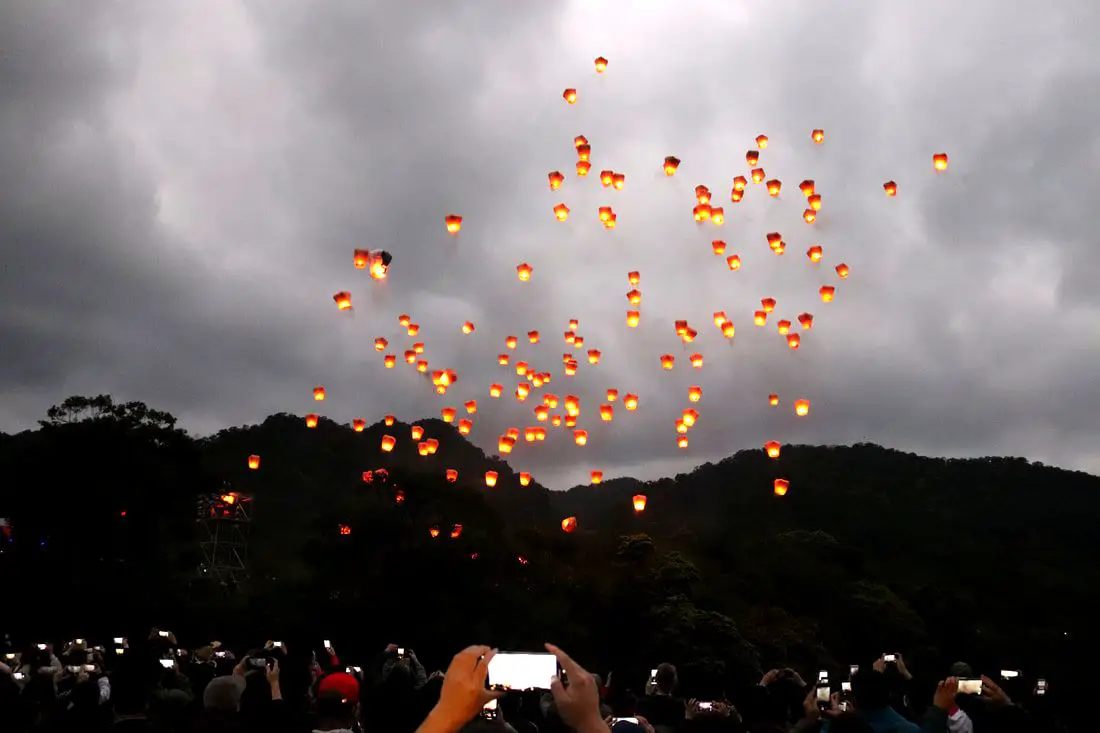
The Pingxi Lantern Festival in New Taipei has some of the most popular attractions in Northern Taiwan, and is known as one of the best festivals in the world. Thousands of lanterns are set off during the festival, to celebrate the traditional Chinese Spring Lantern Festival Holiday. It is definitely worth experience if you are in Taiwan during Lantern Festival.
Background: The practice of lighting off sky lanterns in Taiwan began in Shifen, when during the Qing Dynasty local villagers would flee into the mountains during raids from bandits. Once the bandits had left, the remaining villagers sent sky lanterns into the air to let the fleeing villagers know that it was safe to come down from the mountains. The people of Shifen send off sky lanterns as a symbol of peace, and celebrate every year during Lantern Festival (元宵節), a Chinese holiday. Setting off sky lanterns as a tourist attraction began in the 1990's and you can find people lighting off lanterns every day from Shifen. Since 1990 the Lantern Festival has been held every year (expect 2021 due to COVID-19). The Pingxi Lantern Festival is part of larger festivities around Taiwan at the time, known as the Taiwan Lantern Festival. Because of the hundreds of sky lanterns set off every day, this creates an environmental problem with lantern trash piling around the forests and mountains of Pingxi District. The local people and volunteers help to clean up, but because of the tourism allure associated with lighting off the sky lanterns, it seems that this practice is not going away anytime soon. Date and Time: In 2025 the Pingxi Sky Lantern Festival will be held Wednesday, February 12th from about 6 PM to 8:30 PM. 2025: Wednesday, February 12th from 6 PM to 8:30 PM 2026: Tuesday, March 3rd 2027: Sunday, February 21st 2028: Wednesday, February 9th 2029: Tuesday, February 27th The Lantern Festival is usually held for the entire week that Lantern Festival falls on, which is the 15th day of the first month of the Lunar New Year. Setting off hundreds of lanterns at night is usually done during the evenings. 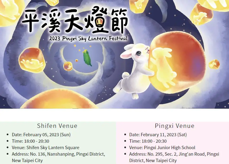
Website: https://2023skylantern.ntpc.gov.tw/#/info Price: Free Tours of Pingxi: You can book a tour of Pingxi on Klook here, TripAdvisor here, or KKday here. Activities Around Pingxi: Don't forget that there are many activities available around Pingxi such as Rock Climbing, Hiking, kayaking, canoeing, snorkeling, SUP / paddle boarding, water biking, Diving, River Tracing / Canyoneering, ATVing, Horse Riding, Cooking Class, photo shoot, Jingtong Sky Lantern Police Station, Shifen Sky Lantern Experience, Waterfall Zipline, Waterfall Diving, and more on Tripadvisor here, Klook here, or KKday here. Hotels Near Pingxi: We recommend Fullon Hotel which has locations in Tamsui and Fulong near the beach (book on Booking.com here and Agoda here). We have stayed at and recommend Gold Mountain Ranch, which is a horse ranch and glamping destination in Jinshan. You can book a night at Gold Mountain Ranch on Klook here. You can also check out our full blog on the ranch here. We have also stayed at and recommend Hai Xia Your Home which is right in front of Fulong Beach (book on Booking.com here, Tripadvisor here, Agoda here, or Hotels.com here). Looking for a hotel? We recommend booking through Booking.com here, which provides the best quality selection of accommodation in Taiwan. Find out where to stay in our Taiwan hotels guide or search for the best hotel deals in Taiwan here. How to get there: By Train: Take the TRA to Ruifang Station, buy the Pingxi Railway line one day pass, and then switch to the Pingxi Railway line. Get off at any station! The main lantern setting is done at Shifen Square, which is right next to the Shifen Waterfall parking lot. Book tickets via the normal train (TRA) on Klook here. You can purchase a discount easy card to use on Pingxi Railway Line on Klook here or KKday here. You can also book a travel pass on Klook here. By Car/Scooter: Take provincial highway 2 east toward Pinglin, then get off the main highway once you reach Shifen. You can drive right or left to reach all of the stations on the Pingxi Railway line. But please know there is limited car parking around the stations. If you are looking for car rentals, you can also search Qeeq here, Klook here, or KKday here. You can also check out our car rental guide here. Looking for scooter rental in Taipei? You can search on Klook here or KKday here to search for options. You can also check out our scooter rental guide here. By Taxi: You can take short rides for about 150 NT, or hire a Taxi for a day for around 150 USD on Klook here. By Bus: You can also book tickets to travel to Pingxi via inter-city bus on Klook here. You can also book a Taipei Sightseeing: Hop On, Hop Off Open Top Bus on TripAdvisor here. By Bicycle: Cycling is the best way to enjoy Taiwan's landscapes if you have the time and energy. Looking for bicycle rentals in Taiwan? You can use Taiwan's many Youbike sharing stations, or search for rentals on KKday here, and search for tours on Klook here. You can also check out our Taiwan cycling guide here. You can also book a Sunset Riverside Bike Ride and Historical Tour, 4 Hour Cycling in Taipei, Ultimate 8-Hour Cycling City Tour, or Taipei City Bike Tour with Night Market Experience on TripAdvisor here. For more information, check out our Taiwan transportation guide here. Map: Please see below: 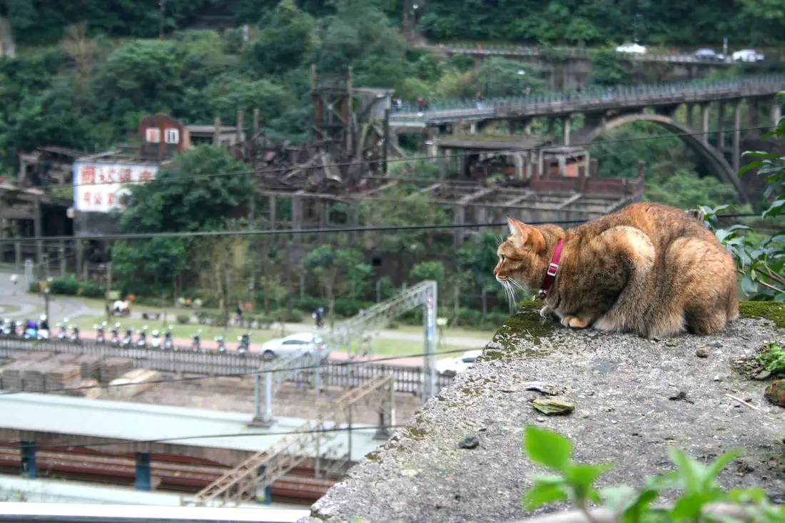
Houtong is a small village connected to the Pingxi Railway in Ruifang District in New Taipei, famous for its many cats. Once a booming mining town with the most coal production in Taiwan, it has now been converted into a tourist destination for cat lovers. Visitors can enjoy the town's rich history as well as hundreds of cats and cat-related shops around the village.
Background: Houtong train station was completed in 1920 during the Japanese colonization of Taiwan, in order to ship coal from mines nearby. The area around the village was once the most prosperous mining town in Taiwan, bringing in hundreds of thousands of tons of coal in a year. At its height, it had 6,000 residents. As the coal mining industry died down and the mining industry was shut down due to safety in the 1990s, the future of Houtong Village was in question. However, by 2008 Houtong Started to reinvent itself as a cat paradise, with many cat loving citizens proposing to bring abandoned cats to the village for a better life. Since then, the town has been a hub for cat lovers and enthusiasts. The Ruisan Coal Preparation Plant opened in 2022 and offers free entrance to visitors. Due to many tourists visiting such a large population of cats, diseases have been known to spread around the village. Sometimes during an outbreak the village is closed to tourists. Volunteer groups often deliver vaccines and medications to the cats. However, it is best to not bring your own pets, wash your hands before and after touching animals, and do not touch the animals' faces and mouths. Hours: 24/7 Price: Free Tours: You can book a tour of Houtong and other nearby places with Klook here or KKday here. How to get there: By Train: Take the TRA train to Ruifang Station, and then switch to the Pingxi Railway line. It will be the first stop. Book tickets via the normal train (TRA) on Klook here. You can book tickets to the high speed rail (HSR) on Klook here or KKDay here. You can also book a shuttle bus on KKDay here or Klook here. By Car/Scooter: Take national highway 2 to Ruifang, then turn left on Ruihou Raod until you reach the village. You can also drive from Jiufen or Jinguashi, which is less than a 10 minute ride. You can also charter a car for a day to Houtong Cat Village on Klook here. If you are looking for car rentals, you can also search Qeeq here, Klook here, or KKday here. You can also check out our car rental guide here. Looking for scooter rental in Taipei? You can search on Klook here or KKday here to search for options. You can also check out our scooter rental guide here. By Taxi: You can take short rides for about 150 NT, or hire a Taxi for a day for around 150 USD on Klook here. By Bus: You can also book tickets to travel to Ruifang via inter-city bus on Klook here. You can also book a Taipei Sightseeing: Hop On, Hop Off Open Top Bus on TripAdvisor here. By Bicycle: Cycling is the best way to enjoy Taiwan's landscapes if you have the time and energy. Looking for bicycle rentals in Taiwan? You can use Taiwan's many Youbike sharing stations, or search for rentals on KKday here, and search for tours on Klook here. You can also check out our Taiwan cycling guide here. You can also book a Sunset Riverside Bike Ride and Historical Tour, 4 Hour Cycling in Taipei, Ultimate 8-Hour Cycling City Tour, or Taipei City Bike Tour with Night Market Experience on TripAdvisor here. For more information, check out our Taiwan transportation guide here. Where to Stay Near Houtong Cat Village: We recommend Fullon Hotel which has locations in Tamsui and Fulong near the beach (book on Booking.com here, Tripadvisor here, Agoda here, or Hotels.com here). We have stayed at and recommend Gold Mountain Ranch, which is a horse ranch and glamping destination in Jinshan. You can book a night at Gold Mountain Ranch on Klook here. You can also check out our full blog on the ranch here. We have also stayed at and recommend Hai Xia Your Home which is right in front of Fulong Beach (book on Booking.com here, Tripadvisor here, Agoda here, or Hotels.com here). Looking for a hotel? We recommend booking through Booking.com here, which provides the best quality selection of accommodation in Taiwan. Find out where to stay in our Taiwan hotels guide or search for the best hotel deals in Taiwan here. Map: Please see below: 
Preface: This blog has taken me countless hours over a few years to compile, so if you want to share the information or photos in this blog, please provide a link and proper citation back to this web page.
The New Taiwan Dollar is the national currency of Taiwan (ROC), and it includes five main bills and five main coins that are currently in circulation. It is one of the sure signs that Taiwan is a free and independent nation. Have you ever wondered what the meaning or significance of the designs on these bills? Well in this blog we will explore these in depth. History: Old Taiwan Dollar: Ever wonder what happened to the old Taiwan Dollar? It was the official currency of Taiwan after 1945, replacing the Japanese Yen that had previously been used at roughly the same price. It was discontinued in 1949 due to hyperinflation that hit China after WWII due to the Chinese Civil War, which also affected Taiwan and the Taiwan Dollar. To help solve hyperinflation, the New Taiwan Dollar was created on June 15, 1949 as the official currency of Taiwan, after the ROC lost the Chinese Civil War and retreated to Taiwan. The currency was valued at 1 New Taiwan Dollar to 40,000 Taiwan Dollars. New Taiwan Dollar Beginnings: The New Taiwan Dollar currency was adopted as the official currency of the Republic of China only in 1961. Before that, Kinmen and Matsu had their own special currency notes, which have been discontinued. In 2001, the New Taiwan Dollar currency stopped being printed at the Bank of Taiwan, and is now printed at Taiwan's Central Bank. The New Taiwan Dollar bills and coins have gone through many changes over the years, but most of them have included either Chiang Kai-shek or Sun Yat-sen on the face of the notes. From 1976 until 2001, most notes were either 10 NT, 100 NT, 500 NT, and 1000 NT. From then until now, there have been five generations or series of notes and coins. This blog will focus on the current fifth series. For a full list of historical notes, click here. Previous Versions: Before the year 2000, prior generations of bank notes were easily copied, as they lacked special marking and printing techniques. Counterfeit bills were often used in night markets and vegetable markets because they would not be scrutinized for their authenticity. In addition, former bills were less durable and could be ruined even if just put through a washing machine cycle. Although current bills can also still be ruined in a washing machine...sigh. Also the fourth generation of bills(which began circulation in 1982) did not include a 20 NT coin or a 200 or 2000 NT bill; and people normally only used 1 NT, 5 NT, 10 NT, 50 NT, 100 NT, 500 NT, and 1000 NT. Because this was not very long ago, part of the reason the 20 NT, 200 NT, and 2000 NT are not widely used is because people are still used to using only 10 NT, 100 NT, 500 NT, and 1000 NT. Current Version: Starting in the year 2000, the central bank began printing the modern fifth generation version of New Taiwan Dollar notes that we use today. The current 100 NT note was first printed in 2000, the 200 NT and 2000 NT notes were first printed in 2001, and the current 500 NT and 1000 NT notes were first printed in 2004. In 2001, the 20 NT coin was introduced, but other coins remained the same. New Taiwan Dollars can be denoted as TWD, NTD, or NT$. Visiting Taiwan soon? You can also find more tours of Taiwan on Klook here or KKday here. You can also check out our full travel guide to Taiwan here. Looking for a hotel? Find out where to stay in our Taiwan hotels guide or search for the best hotels in Taiwan here. Common symbols on the New Taiwan Dollar:
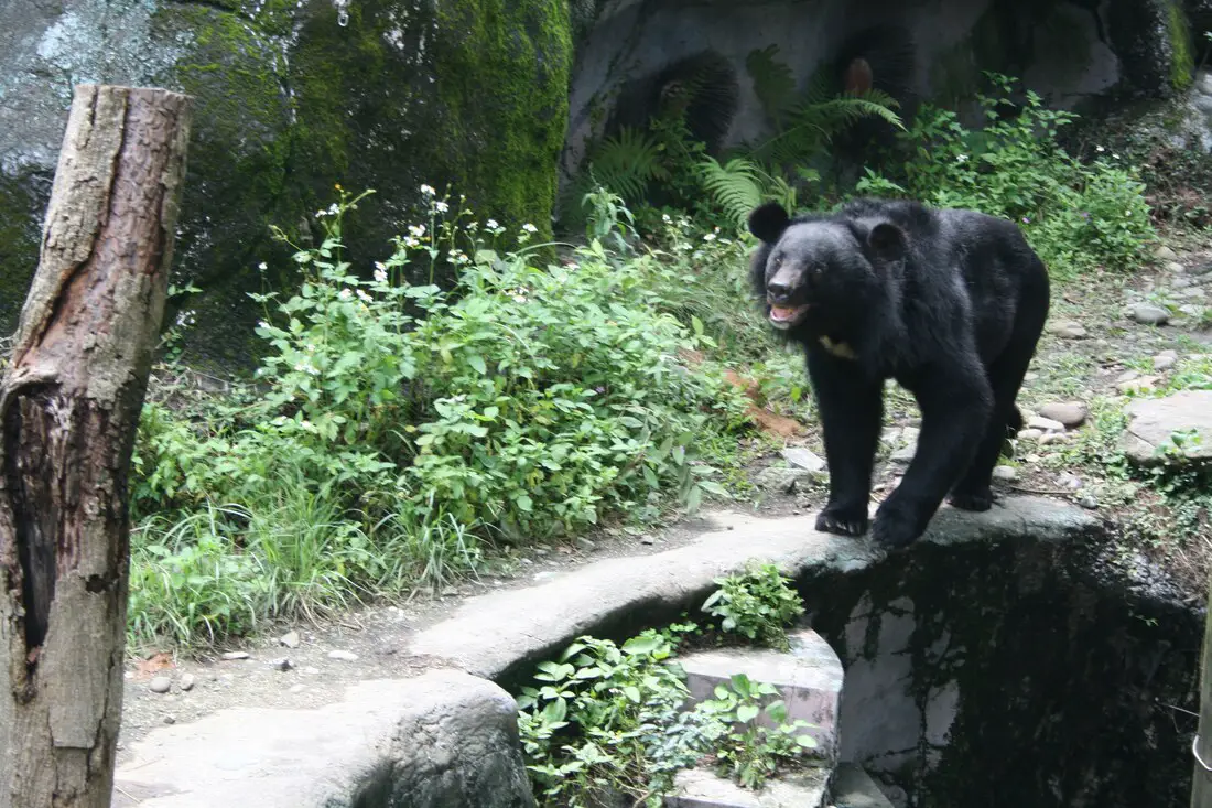
The Taipei Zoo is not only the largest and most varied zoo in Taiwan, it is also one of the best zoos in Asia, and at the same time has an extremely affordable price of only 60 NT per adult. If you have time you should definitely stop by and visit this zoo, if not for anything else but to see Taiwan's ingenious animals like the Formosan Black Bear and Sika Deer which are hard to see in the wild.
Background: The Taipei City Zoo was originally established during the Japanese Era in 1914 near the Yuanshan Hotel. After the ROC took control of Taiwan, elephants, lions, and bears were added to the zoo in 1952. Because there was not enough land to expand the zoo, it was moved to Wenshan District in 1986. Two employees have been killed by animals, one from an elephant and one from a black bear both in the 1970s. There have been no fatalities at the zoo since. The Maokong Gondola was built next to the zoo in 2007, connecting Taipei Zoo with Maokong. The current zoo includes a Taiwan indigenous animal exhibit, children's petting zoo, tropical rain forest exhibit, desert animal exhibit, Australian and African animal exhibits, tropical animal exhibit, petting zoo, insect exhibit, and bird exhibit. There is also indoor Panda exhibit, insect exhibit, amphibian and reptile exhibit, koala exhibit, and penguin exhibit. Hours: 9 AM to 5 PM, tickets are not sold after 4:00 PM. Sometimes in the summer twilight hours are extended to 9:00 PM, but it's not worth going as most all of the animal exhibits are closed after 5:00 PM. Price: 60 NT per person You can book discount tickets to Taipei Zoo on Klook here or KKday here. Tours: You can also book a Taipei Zoo and Maokong Gondola tour on TripAdvisor here. You can also search for tours on Klook here, or KKday here. Hotels in Taipei: We have stayed at and recommend Ximending Amba, which is within walking distance of Ximending shopping district (book on Booking.com here, Hotels.com here, Tripadvisor here, Expedia here, Kayak here, Trip.com here, or Agoda here). We also have stayed at and recommend and Fu Chang Hotel in Ximending, which is within walking distance of Ximending shopping district (book on Booking.com here, Tripadvisor here, or Agoda here). We also have stayed at and recommend the Yuanshan Grand Hotel, once the tallest building in Taiwan and still the most grand (book on Booking.com here, Tripadvisor here, or Agoda here). Looking for a hotel? We recommend booking through Booking.com here, which provides the best quality selection of accommodation in Taiwan. Find out where to stay in our Taiwan hotels guide or search for the best hotel deals in Taiwan here. Just to let you know, if you book using the links above, we get some commission at no cost to you, and you can help support our blog. Some of the Klook links may not work if you are using an Ad blocker. You can click here to receive $5 USD on your first Klook purchase. How to get there: By MRT: Take the brown line MRT to the Taipei Zoo station, then walk north a few hundred meters until you reach the zoo entrance. You can purchase a discount easy card to use on the MRT from Klook here or KKday here. You can also book an MRT travel pass on Klook here. By Car/Scooter: Drive to the Taipei Zoo (via highway 3 or county road 106), and park somewhere on the street or in a parking lot, then walk to the zoo entrance. Looking for scooter rental in Taipei? You can search on Klook here or KKday here to search for options. You can also check out our scooter rental guide here. If you are looking for car rentals, you can also search Qeeq here, Klook here, or KKday here. You can also check out our car rental guide here. By Bicycle: Cycling is the best way to enjoy Taiwan's landscapes if you have the time and energy. Looking for bicycle rentals in Taiwan? You can use Taiwan's many Youbike sharing stations, or search for rentals on KKday here, and search for tours on Klook here. You can also check out our Taiwan cycling guide here. You can also book a Sunset Riverside Bike Ride and Historical Tour, 4 Hour Cycling in Taipei, Ultimate 8-Hour Cycling City Tour, or Taipei City Bike Tour with Night Market Experience on TripAdvisor here. For more information, check out our Taiwan transportation guide here. Map: Please see below: 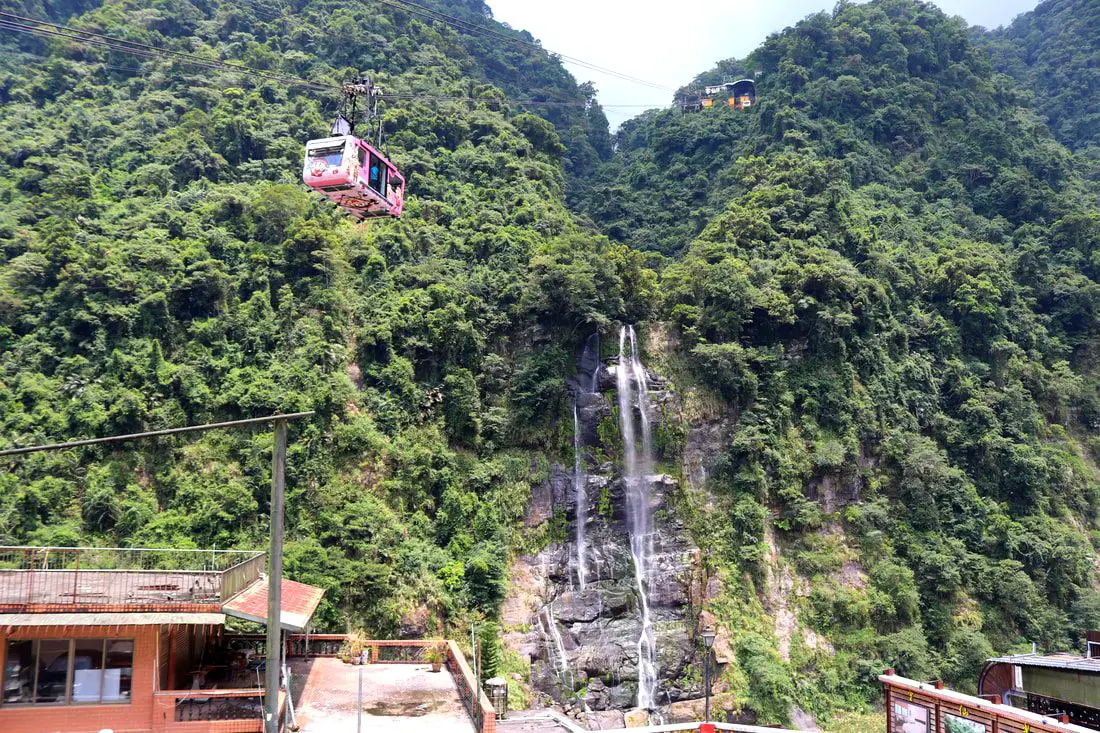
Wulai Waterfall is the highest waterfall in northern Taiwan. Here you can find a street with snacks and restaurants, and a gondola that leads to a second tier of the waterfall and an amusement park. In addition there are hikes, wildlife, and endless mountain scenery to explore.
Background: Wulai was originally an Atayal aborigine village, its name meaning hot and poisonous. There has always been natural hot springs in Wulai, but much of that water has been channeled into hotels and public bathhouses. The free hot springs stood at the bottom of the hill next to the river, and was a collection of used hot spring water from the hotels and paid hot springs above. In its prime, it boasted the largest free outdoor hot springs in Taiwan. Recently the District of Wulai in New Taipei has become a major tourist attraction, partly because of its close proximity to Taipei. It has museums, waterfalls, a gondola, a train, an old street night market, and most of all hot springs. The main delicacies on the old street are Taiwan ingenuous foods such as wild boar meat and rice steamed in bamboo. Wulai waterfall is 80 meters high, making it the highest waterfall in northern Taiwan. It's highest point sits at 230 meters above sea level, and drops to 150 meters above sea level. The waterfall is also about 10 meters wide. Yunceng Amusement Park began construction in 1960 and was completed in 1970. It includes a gondola, hotel, swimming pool, canoe pond, and other activities. Originally it had a roller coaster, pirate ship, and other rides, but these have all been taken down. Hours: Waterfall: 24/7 Cable Car and Yun Hsien Amusement Park Entrance: 9 AM to 4:30 PM You can book tickets to the gondola and to Yun Hsien theme park on Klook here or KKday here. Neidong Waterfall: 8 AM to 5 PM. You can book tickets to Neidong Forest Recreation Area on KKday here or Klook here. Price: Wulai Waterfall: Free Cable Car and Yun Hsien Amusement Park Entrance: 220 NT per person You can book tickets to the gondola and to Yun Hsien theme park on Klook here or KKday here. Neidong Waterfall: 65 NT per person. You can book tickets on KKday here or Klook here. Hot Spring Bath: 300-500 NT. You can look for hot spring bath experiences on Klook here or KKday here. Tours and Activities: You can book a Taiwan Wulai Aboriginal Tribe afternoon Tour on TripAdvisor here. You can also book a tour of Wulai on KKday here. You can also book a ticket on the Wulai Train on Klook here, or a river tracing experience in Wulai on Klook here, or SUP paddleboarding experience in Wulai on KKday here, hot spring baths on Klook here or KKday here, on or tickets to the gondola and to Yun Hsien theme park on Klook here or KKday here. Hotels in Wulai: There are many hot spring hotels in Wulai that have a hot spring tub right in the room. We have stayed at and recommend Wulai SungLyu Hot Spring Resort, which is a hot spring resort with great views just above Wulai Old Street. You can book on Booking.com here, Agoda here, Hotels.com here, TripAdvisor here, Trip.com here, Klook here, Kayak here, or Expedia here. Looking for a hotel? We recommend booking through Booking.com here, which provides the best quality selection of accommodation in Taiwan. Find out where to stay in our Taiwan hotels guide or search for the best hotel deals in Taiwan here. How to get there: By Bus: From central Taipei, take bus 849 to Wulai Waterfall. The trips takes about an hour and a half. You can purchase a discount easy card to use on a bus to Wulai on Klook here or KKday here. You can also book a Taipei travel pass on Klook here. By Car: From Taipei, take provincial highway 9甲 to Wulai. There is a large paid parking garage in front of the old street. You may also be able to find free parking further up the road closer to the waterfall but car parking is very limited. If you are looking for car rentals, you can also search Qeeq here, Klook here, or KKday here. You can also check out our car rental guide here. Looking for scooter rental in Taipei? You can search on Klook here or KKday here to search for options. You can also check out our scooter rental guide here. By Taxi: You can take short rides for about 150 NT, or hire a Taxi for a day for around 150 USD on Klook here. By Bicycle: Cycling is the best way to enjoy Taiwan's landscapes if you have the time and energy. Looking for bicycle rentals in Taiwan? You can use Taiwan's many Youbike sharing stations, or search for rentals on KKday here, and search for tours on Klook here. You can also check out our Taiwan cycling guide here. You can also book a Sunset Riverside Bike Ride and Historical Tour, 4 Hour Cycling in Taipei, Ultimate 8-Hour Cycling City Tour, or Taipei City Bike Tour with Night Market Experience on TripAdvisor here. For more information, check out our Taiwan transportation guide here. Map: Please see below of the places covered in this blog: 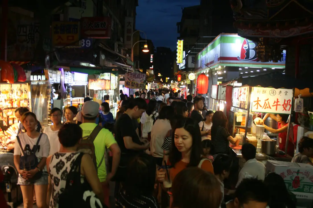
Shilin Night Market (aka Shihlin Night Market) is the largest night market in Taipei and also one of the most popular. Full of delicious street food, small hole-in-the-wall restaurants, souvenirs, and clothes, it is a great destination to experience Taiwan's night market culture.
Background: Shihlin Night market lies next to Jiantan MRT station, surrounded by Wenlin Road (文林路), Jihe Road (基河路), and small alleyways Xiaobei Street (小北街), and Xiaoxi Street (小西街), forming a giant triangle making it the biggest night market in Taipei City by area. Shihlin may have the most food stalls and restaurants of any night market in Taiwan, and is often regarded as the best or one of the favorite night markets in Taiwan by both locals and tourists alike. The night market features multiple alleyways as well as an underground food court and underground parking garage. Located next to Mingchuan University, Soochow University, China Culture University, and Shih Chien University, it has a constant supply of hungry university students visiting every day. Shilin Market was first established in 1909 near the Matzu Cicheng Temple, which now lies at the center of the night market. Before that is was a resting stop for cargo on the way to Dadaocheng. In 1998, Shilin Market was named as a historical monument. After that from 1999-2011, the market underwent multiple renovations, and relocated to a temporary structure near Jiantan MRT station, until renovations were completed in 2012. Hours: Around 4 PM until 12 Midnight, every day. Tours: You can book a Shilin Night Market Walking Tour With a Private Tour Guide on TripAdvisor here or Klook here. Hotels in Taipei: High end: We have stayed at and recommend the Yuanshan Grand Hotel, once the tallest building in Taiwan and still the most grand (book on Booking.com here, Tripadvisor here, or Agoda here). We have also stayed at and recommend the Grand Hyatt (book on Booking.com here, Tripadvisor here, Agoda here, or Hotels.com here), Marriot (book on Booking.com here, Tripadvisor here, Agoda here, or Hotels.com here), Sheraton (book on Booking.com here, Tripadvisor here, Agoda here, or Hotels.com here), Shangri-la (book on Booking.com here, Tripadvisor here, Agoda here, or Hotels.com here), and Regent (book on Booking.com here, Tripadvisor here, Agoda here, or Hotels.com here), which are all very high quality hotels in the middle of Taipei City. We also recommend Fullon Hotel which has locations in Tamsui and Fulong near the beach (book on Booking.com here, Tripadvisor here, Agoda here, or Hotels.com here). Budget Hotels: We have stayed at and also recommend Fu Chang Hotel in Ximending, which is within walking distance of Ximending shopping district (book on Booking.com here, Tripadvisor here, or Agoda here). We have also stayed at and recommend Hai Xia Your Home which is right in front of Fulong Beach (book on Booking.com here, Tripadvisor here, Agoda here, or Hotels.com here). Looking for a hotel? We recommend booking through Booking.com here, which provides the best quality selection of accommodation in Taiwan. Find out where to stay in our Taiwan hotels guide or search for the best hotel deals in Taiwan here. Just to let you know, if you book using the links above, we get some commission at no cost to you, and you can help support our blog. Some of the Klook links may not work if you are using an Ad blocker. You can click here to receive $5 USD on your first Klook purchase. How to get there: By MRT: Take the Red Line to Jiantan Station and then take exit 1 north out of the station. The night market is right across the road. You can also book an MRT travel pass on Klook here. By Scooter: Take Zhongshan North Road out of Taipei and wind around Yuanshan Hotel into Shilin. You can park on the right side of the road next to Jiantan Station. Looking for scooter rental in Taipei? You can search on Klook here or KKday here to search for options. You can also check out our scooter rental guide here. By Car: Take Zhongshan North Road out of Taipei and wind around Yuanshan Hotel into Shilin. There are many parking garages around the night market. If you are looking for car rentals, you can also search Qeeq here, Klook here, or KKday here. You can also check out our car rental guide here. By Bicycle: Cycling is the best way to enjoy Taiwan's landscapes if you have the time and energy. Looking for bicycle rentals in Taiwan? You can use Taiwan's many Youbike sharing stations, or search for rentals on KKday here, and search for tours on Klook here. You can also check out our Taiwan cycling guide here. You can also book a Sunset Riverside Bike Ride and Historical Tour, 4 Hour Cycling in Taipei, Ultimate 8-Hour Cycling City Tour, or Taipei City Bike Tour with Night Market Experience on TripAdvisor here. For more information, check out our Taiwan transportation guide here. Map: Please see below: 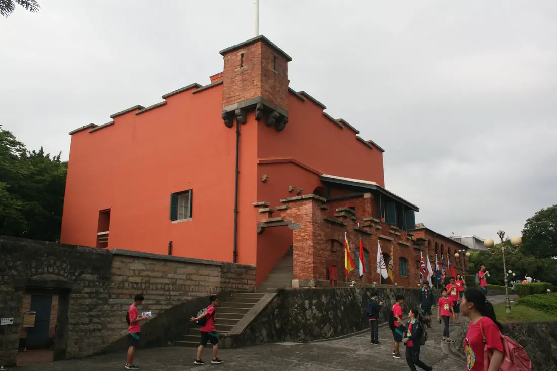
Fort San Domingo (aka 紅毛城 Hongmaocheng, “City of Red Hair") is one of the oldest buildings in Taiwan, with a nearly 400 year history. Originally built by the Spanish, it was handed over to nine different nations including the Dutch, Qing, Japan, British, Australia, USA, and the ROC. Now it is a popular tourist destination in Tamsui.
Background: Fort San Domingo was originally a wooden fort built by the Spanish who were vying for control of Taiwan in 1628. Later the fort came into Dutch control in 1642, and the Spanish were driven from Taiwan. In the process, the Spanish razed the fort to the ground. The fort was rebuilt in brick by the Dutch. The Dutch were expelled from Taiwan thanks to Konxinga and his Ming loyalists. After the Qing dynasty took Taiwan from the Ming loyalists, they repaired the fort in 1724. The local Han Chinese at the time called the fort "Red Hair Fort 紅毛城" as a racial slur to the Dutch. Later, the fort was leased to the British government, who continued to keep a presence there until 1972, and later it was given for a short time to Australia and the USA, and then given to the ROC government in 1980. Now the government maintains the fort as a tourist attraction. Hours: 9:30 AM to 5 PM Price: 80 NT per person (includes passage to the British Consulate, Hobe Fort, and the Little White House). You can book tickets to this fort and nearby historic sites on Klook here or KKday here. Hotels in Tamsui: We have stayed at and recommend Fullon Hotel which has locations in Tamsui and Fulong near the beach (book on Booking.com here, Tripadvisor here, Agoda here, Klook here, Trip.com, Kayak here, or Hotels.com here). We have also stayed at and recommend the Yuanshan Grand Hotel, once the tallest building in Taiwan and still the most grand (book on Booking.com here, Tripadvisor here, Agoda here, Trip.com here, or Kayak here). Looking for a hotel? We recommend booking through Booking.com here, which provides the best quality selection of accommodation in Taiwan. Find out where to stay in our Taiwan hotels guide or search for the best hotel deals in Taiwan here. How to get there: By Car/Scooter: Take provincial highway 2 north from Taipei until you reach Tamsui. The fort is past Tamsui Old Street on highway 2. Parking can be hard to find, but there should be plentiful parking at Tamsui Elementary School and other places further away. Looking for scooter rental in Tamsui? You can search on Klook here or KKday here to search for options. You can also check out our scooter rental guide here. If you are looking for car rentals, you can also search Qeeq here, Klook here, or KKday here. You can also check out our car rental guide here. By MRT: Take the red line MRT north to Tamsui station and walk 1 KM north or take a bus to the fort. You can purchase a discount easy card to use on the MRT from Klook here or KKday here. You can also book an MRT travel pass on Klook here. By Bicycle: Cycling is the best way to enjoy Taiwan's landscapes if you have the time and energy. Looking for bicycle rentals in Taiwan? You can use Taiwan's many Youbike sharing stations, or search for rentals on KKday here, and search for tours on Klook here. You can also check out our Taiwan cycling guide here. Map: Please see below: 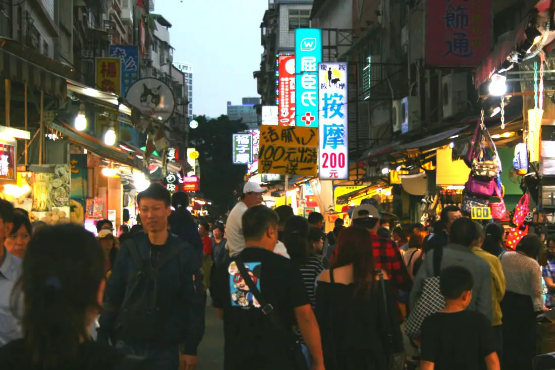
Tamsui Old Street (aka Danshui Old Street or Tamshui Old Street) is a street in Tamsui District of New Taipei famous for its delicious food and historical atmosphere. It is one of the most popular and well known old streets in all of Taiwan. Some local delicacies here include A-gei, iron eggs, fried squid, and other seafood.
Background: Tamsui Old Street developed alongside the Tamsui Harbor, which was opened in 1860 during the Qing Dynasty as part of the Treaty of Tientsin which ended the Second Opium War. It was one of only eight ports in the entire Qing empire that was open to trade with the west. As a result, it became a focal point for trade in Taiwan. It was also the western terminus of the Danlan Old Trail, which was a network of roads and trails that sent tea and other goods from Yilan to Tamsui. It remained an important port until it started to silt in during the 1900s, and after the construction of Keelung Harbor. There are also a number of important historical buildings near Tamsui Old Street such as Fort San Domingo, Hobe Fort, and others. Tamsui Old Street has always existed next to the old harbor, and recently there have been projects from the local government to improve tourism, such as widening roads and making a riverside walkway. With the completion of the Red Line MRT with its terminus in 1997 right at the edge of the old street, Tamsui became an extremely popular destination for residents in greater Taipei and remains to be so today. Hours: Every day 11 AM - 8 PM. Price: Free Tours: You can book a tour of Tamsui on TripAdvisor here, KKday here, or Klook here. You can book a tour to Taiwan's North Coast on TripAdvisor here, Klook here, or KKday here. Activities: There are many activities available around Tamsui such as, SUPing, Sand Bar Digging, Horse Riding, Lover's Tower, Sailing, Yachting, Happy Island Parent Child Gymnasium, Chi Po Lin Museum and more on TripAdvisor here, KKday here, or Klook here. Hotels in Tamsui: We have stayed at and recommend Fullon Hotel which has locations in Tamsui and Fulong near the beach (book on Booking.com here, Tripadvisor here, Agoda here, Klook here, Trip.com, Kayak here, or Hotels.com here). We have also stayed at and recommend the Yuanshan Grand Hotel, once the tallest building in Taiwan and still the most grand (book on Booking.com here, Tripadvisor here, Agoda here, Trip.com here, or Kayak here). Looking for a hotel? We recommend booking through Booking.com here, which provides the best quality selection of accommodation in Taiwan. Find out where to stay in our Taiwan hotels guide or search for the best hotel deals in Taiwan here. How to get there: By Car/Scooter: Take provincial highway 2 north from Taipei until you reach Tamsui. The old street is near the Tamsui MRT station. Parking can be hard to find, but there should be plentiful parking at Tamsui Elementary School and other places further away. Looking for scooter rental in Tamsui? You can search on Klook here or KKday here to search for options. You can also check out our scooter rental guide here. If you are looking for car rentals, you can also search Qeeq here, Klook here, or KKday here. You can also check out our car rental guide here. By MRT: Take the red line MRT north to Tamsui station and you have arrived. You can purchase a discount easy card to use on the MRT from Klook here or KKday here. You can also book an MRT travel pass on Klook here. By Bicycle: Cycling is the best way to enjoy Taiwan's landscapes if you have the time and energy. Looking for bicycle rentals in Taiwan? You can use Taiwan's many Youbike sharing stations, or search for rentals on KKday here, and search for tours on Klook here. You can also check out our Taiwan cycling guide here. Map: Please see below: 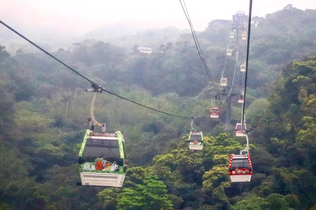
Maokong is only one of a few Gondolas in Taiwan, but it is the most accessible. You can get there via the Taipei MRT. After embarking on the Gondola, you can view grand vistas of Southern Taipei, and then explore the mountainous streets of Maokong, which has tea shops, street food, restaurants, temples, hiking trails, and great views.
Background: The Maokong Gondola was completed in 2007 to improve transportation to Maokong, a tea growing area in Southern Wenshan District of Taipei City. Before, the district could only be reached by small mountain roads. The Gondola was closed from 2008-2010 due to Typhoon damage. Popular activities in the area include tea drinking, hiking, and picture taking. There are four stations on the Gondola: Taipei Zoo Station, Taipei Zoo South Station, Zhinan Temple Station, and Maokong Station. A one way trip takes 12 minutes, and gondola cars which can fit up to eight people (five people in glass cars) come every few seconds. Maokong gets its name from the eroded holes in the rocks around the area; the name literally means “Cat Hole.” The area has been one of the largest areas for tea production in Taipei since the Qing Dynasty. After the completion of the Gondola in 2007, tourists to the area have increased significantly. Hours: 9 AM to 9 PM Price: 120 NT per person one way from Taipei Zoo Station to Maokong Station. 50 NT per trip for Taipei City residents. You can book discount tickets to Maokong Gondola on Klook here or KKday here. Tours: You can also book a Taipei Zoo and Maokong Gondola tour, a Chih Nan Temple & Gondola Experience, or a Maokong Tea & Shenkeng Stinky Tofu Private Day Tour with English-Speaking on TripAdvisor here. You can also search for tours on Klook here, or KKday here. Hotels in Taipei: We have stayed at and recommend Ximending Amba, which is within walking distance of Ximending shopping district (book on Booking.com here, Hotels.com here, Tripadvisor here, Expedia here, Kayak here, Trip.com here, or Agoda here). We also have stayed at and recommend and Fu Chang Hotel in Ximending, which is within walking distance of Ximending shopping district (book on Booking.com here, Tripadvisor here, or Agoda here). We also have stayed at and recommend the Yuanshan Grand Hotel, once the tallest building in Taiwan and still the most grand (book on Booking.com here, Tripadvisor here, or Agoda here). Looking for a hotel? We recommend booking through Booking.com here, which provides the best quality selection of accommodation in Taiwan. Find out where to stay in our Taiwan hotels guide or search for the best hotel deals in Taiwan here. Just to let you know, if you book using the links above, we get some commission at no cost to you, and you can help support our blog. Some of the Klook links may not work if you are using an Ad blocker. You can click here to receive $5 USD on your first Klook purchase. How to get there: By MRT: Take the brown line MRT to the Taipei Zoo station, then walk south a few hundred meters until you reach the gondola station on the east side of the main road. You can purchase a discount easy card to use on the MRT from Klook here or KKday here. You can also book an MRT travel pass on Klook here. By Car/Scooter: Drive to the Taipei Zoo, and park somewhere on the street or in a parking lot, the walk to the Gondola Station. You can search on Klook here or KKday here to search for options. You can also check out our scooter rental guide here. If you are looking for car rentals, you can also search Qeeq here, Klook here, or KKday here. You can also check out our car rental guide here. (You can also take the Gondola from the southern station inside the Zoo or from Zhinan Temple) By Bicycle: Cycling is the best way to enjoy Taiwan's landscapes if you have the time and energy. Looking for bicycle rentals in Taiwan? You can use Taiwan's many Youbike sharing stations, or search for rentals on KKday here, and search for tours on Klook here. You can also check out our Taiwan cycling guide here. You can also book a Sunset Riverside Bike Ride and Historical Tour, 4 Hour Cycling in Taipei, Ultimate 8-Hour Cycling City Tour, or Taipei City Bike Tour with Night Market Experience on TripAdvisor here. For more information, check out our Taiwan transportation guide here. Map: Please see below: 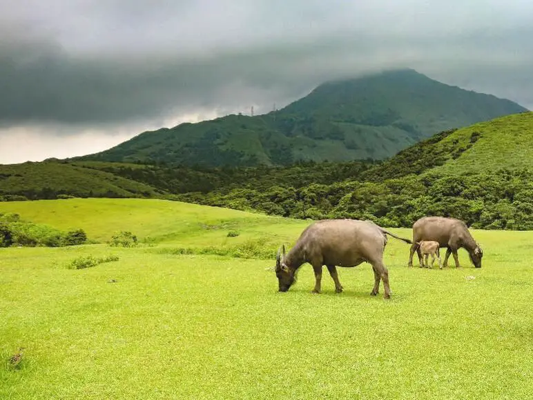
Qingtiangang in Yangmingshan National Park is a large grassland that lies on top of an old lava terrace. It is famous for the water buffalo that congregate here to graze and is one of the most popular areas in the park. Besides enjoying views of wild water buffalo, there are also many hiking trails and historic trails nearby. Overall it is a family-friendly destination and one of the most popular attractions in Taipei City.
Background: Qingtiangang, literally meaning "Hill Holding up Heaven" gets its name from the KMT Qingtian garrison that once guarded the hills and grasslands here. Officially it lies in Shilin District of Taipei, but parts of the grassland also lie in Jinshan District of New Taipei. The grassland lies 770 meters above sea level. The area known as Yangmingshan now was formed by volcanoes about 700,000 years ago, forming many mountains about 1000 meters or less in northwestern Taiwan. The park still features active volcanoes, vents, and hot springs. The original name of the area was Caoshan (grass mountain 草山). During the Qing Dynasty, the area was used to harvest sulfur, and many of the hills were burned to help catch sulfur thieves, Qingtiangang likely being one of these areas. Sulfur mining at Dayoukeng Crater in Yangmingshan National Park started in the Qing Dynasty by a British mining company who first obtained the rights to mine here in 1897. Currently you can find lots of old mining equipment that were abandoned here. The Yulu Old Trail was built near Dayoukeng to transport mining materials, and extended over to Qingtiangang. Mining sulfur ended with the formation of Yangmingshan National Park. In 1927 during the Japanese era, Yangmingshan was made as the first national park in Taiwan, then known as Datunshan National Park Association. The area around Qingtiangang to Lengshuikeng was made into a ranch for water buffalo, and grass from Japan was planted here for them to graze. In 1950 after the ROC took Taiwan, Chiang Kai-shek renamed the park after the philosopher Wang Yangming, and called the area Yangmingshan. The KMT kept the ranch at Qingtiangang and continued to maintain it. They also built bunkers here and kept a garrison of troops. In 1985, after resolving many land disputes, Yangmingshan National Park was officially designated as a national park in the ROC era. In2018, a mother died after being pushed over by a water buffalo at Qingtiangang. In 2020, the family was awarded NT$3.96 million from the park and wooden fences were built around the grasslands shortly after. The water buffalo at Qingtiangang are actually closely watched and cared for. Although they roam free around Yangmingshan, they are watched over by the Agricultural Associations of Jinshan, Shilin, Yangmingshan, and Beitou, and well as the national park management. In the winter of 2020 which was unusually wet, tens of cows began to die of malnutrition, therefore the park took steps to supplement the diet of the remaining cattle. Many cows were brought to lower eve lavations for rehabilitation before being released back to Yangmingshan. Due to its easy accessibility and nearby attractions such as Lengshuikeng and Qixingshan, it is a popular stop in Yangmingshan and has a parking lots and a visitor's center. In addition, it is one of the most popular tourist destinations in Taipei City. Hours: The visitor's center is open from 9 AM to 4:30 PM. Price: Free (car parking 30-50 NT, scooter parking 20 NT) You can book tours to Yangmingshan on TripAdvisor here, Klook here, or KKday here or here. Tours: You can check out tours to Yangmingshan such as a One-day Yangmingshan NP Beitou Hot Spring Park and Tamsui Tour Package, Beitou and Yangmingshan Day Tour from Taipei, One Day Hike around Yangmingshan, or Private Yangmingshan Volcano Tour and more on TripAdvisor here, Klook here, or KKday here. Hotels in Taipei: High end: We have stayed at and recommend the Yuanshan Grand Hotel, once the tallest building in Taiwan and still the most grand (book on Booking.com here, Tripadvisor here, or Agoda here). We also recommend Fullon Hotel which has locations in Tamsui and Fulong near the beach (book on Booking.com here, Tripadvisor here, Agoda here, or Hotels.com here). Budget Hotels: We have stayed at and also recommend Fu Chang Hotel in Ximending, which is within walking distance of Ximending shopping district (book on Booking.com here, Tripadvisor here, or Agoda here). We have also stayed at and recommend Hai Xia Your Home which is right in front of Fulong Beach (book on Booking.com here, Tripadvisor here, Agoda here, or Hotels.com here). Looking for a hotel? We recommend booking through Booking.com here, which provides the best quality selection of accommodation in Taiwan. Find out where to stay in our Taiwan hotels guide or search for the best hotel deals in Taiwan here. How to get there: By Car/Scooter: From Taipei, take provincial highway 2A north to the Zhuzihu Lookout. Keep right until you reach the turnoff the the Qingtiangang parking lot. Car parking is limited on weekends and the number of cars allowed up the mountain is also limited. There is also paid scooter parking. On weekends this place can be the most popular place in the park, and cars can be backed up for up to an hour or more, so consider taking a scooter or bus. Looking for scooter rental in Taipei? Check out Qeeq here, Klook here, or KKday here to search for options. You can also check out our scooter rental guide here. If you are looking for car rentals, you can also search Qeeq here, Klook here, or KKday here. You can also check out our car rental guide here. By Bus: From Beitou MRT Station, Take Little Bus 9 (小9) to Qingtiangang Station (擎天崗). You can book tickets to travel to Taipei via inter-city bus on Klook here. By Bicycle: Cycling is the best way to enjoy Taiwan's landscapes if you have the time and energy. Looking for bicycle rentals in Taiwan? You can use Taiwan's many Youbike sharing stations, or search for rentals on KKday here, and search for tours on Klook here. You can also check out our Taiwan cycling guide here. ​You can also book a Sunset Riverside Bike Ride and Historical Tour, 4 Hour Cycling in Taipei, Ultimate 8-Hour Cycling City Tour, or Taipei City Bike Tour with Night Market Experience on TripAdvisor here. Map: Please see below: 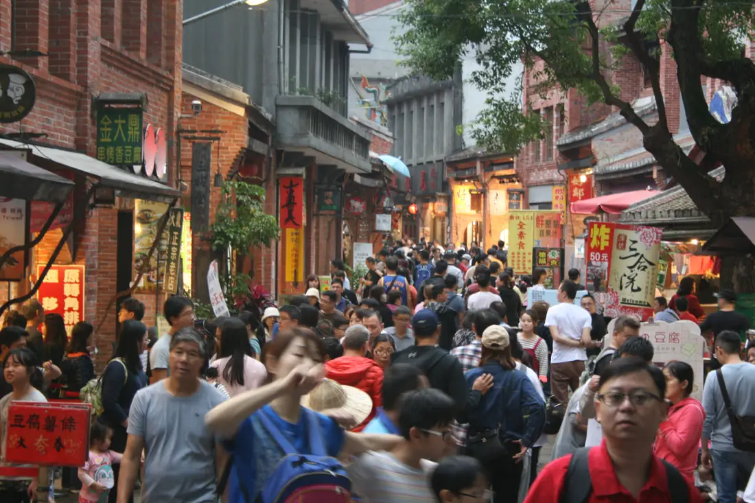
Shenkeng Old Street is one of the largest and busiest old streets in New Taipei, known for its famous tofu delicacies, and old Taiwan feel. Here one can enjoy delicious food, beautiful scenery, and buy nostalgic Taiwan related souvenirs. The Tofu here is truly incredible; Shenkeng is known as the Tofu capital of Taiwan, so you should definitely stop by here on your next trip to Taipei.
Background: During the Qing Dynasty, the town of Shenkeng was an important stop along the Danlan Old Trail (淡蘭古道 which means the road between Tamsui and Yilan), which was split into three paths, and Shenkeng was on the Southern Path. The Southern Path winded from Mengjia Old Street to Liuzhangli, then to Shengkeng which was a major business center at the time. From Shenkeng the road then went to Shiding, Pinglin, and then Yilan. The Southern path was the quickest way to Yilan. In addition, there was a boat dock in Shenkeng that connected it to Mengjia Old Street in what is now central Taipei, making it an important shipping point for tea grown in the mountains nearby. During the Japanese Era in 1915, Shenkeng Old Street was made wider by knocking out the first floors on each side of the street for pedestrian traffic, which can still be seen today as a defining feature of Shenkeng Old Street. After World War 2, the train to Yilan replaced the need for a boat dock for shipping in Shenkeng, and the town slowly fell out of importance. National Highway 3 and National highway 5 were constructed near Shenkeng in 1993 and2006 respectively, making Shenkeng again an important stop on the way to Yilan. In 2008 the New Taipei City government along with local residents created the Shenkeng Historical District and paved the way for the restoration and tourism on the old street. Since then it has been a major tourist attraction for Taiwanese locals. Delicacies: Local delicacies at Shengkeng Old Street include Stinky Tofu, Fried Tofu, Tofu Hot Pot, Tofu Ice Cream, Read Bean Soup, Zongzi, and various other tofu related products. Tofu in Chinese cuisine is similar to cheese in the West. It requires fermentation creating various flavors. Hours: Every Day from about 10 AM to 10 PM, with more shops opening later in the day. Price: Free When to go: If you go during weekends or holidays, it can get really crowded but that is also the time when most all of the shops and stalls are open. If you want to avoid the crowds you can try going early in the afternoon when it is not as busy, Tours: You can book Maokong Tea & Shenkeng Stinky Tofu Private Day Tour on TripAdvisor here. You can also book a Private Street Food Tour of Taipei on TripAdvisor here, KKday here or Klook here. Hotels in Taipei: We have stayed at and recommend the Yuanshan Grand Hotel, once the tallest building in Taiwan and still the most grand (book on Booking.com here, Tripadvisor here, or Agoda here). We have stayed at and also recommend Fu Chang Hotel in Ximending, which is within walking distance of Ximending shopping district (book on Booking.com here, Tripadvisor here, or Agoda here). Looking for a hotel? We recommend booking through Booking.com here, which provides the best quality selection of accommodation in Taiwan. Find out where to stay in our Taiwan hotels guide or search for the best hotel deals in Taiwan here. How to get there: By Scooter: Take local highway 106 east from Muzha (Wenshen District) or local highway 109 south from Nangang District. The old street is right in the middle of town. You can park for free at the park to the north of the old street. Looking for scooter rental in Taipei? You can search on Klook here or KKday here to search for options. You can also check out our scooter rental guide here. By Car: You can take national Highway 5 and get off at the Shiding exit, or take National Highway 3 and get off at the Shenkeng Exit. There is parking near the southern entrance in the form of a mechanical parking garage, and there is also underground parking under the park to the north of the old street. If you are looking for car rentals, you can also search Qeeq here, Klook here, or KKday here. You can also check out our car rental guide here. By Bus: There are a number of buses that pass by the old street coming from Wenshan District or Nangang District of Taipei that leave from near the Blue Line Nangang Exhibition Center Station or Brown line MRT Taipei Zoo/Muzha Station. You can also book tickets to travel to Shifen via inter-city bus on Klook here. You can also book a Taipei Sightseeing: Hop On, Hop Off Open Top Bus on TripAdvisor here. By Bicycle: Cycling is the best way to enjoy Taiwan's landscapes if you have the time and energy. Looking for bicycle rentals in Taiwan? You can use Taiwan's many Youbike sharing stations, or search for rentals on KKday here, and search for tours on Klook here. You can also check out our Taiwan cycling guide here. You can also book a Sunset Riverside Bike Ride and Historical Tour, 4 Hour Cycling in Taipei, Ultimate 8-Hour Cycling City Tour, or Taipei City Bike Tour with Night Market Experience on TripAdvisor here. For more information, check out our Taiwan transportation guide here. Map: Please see below: 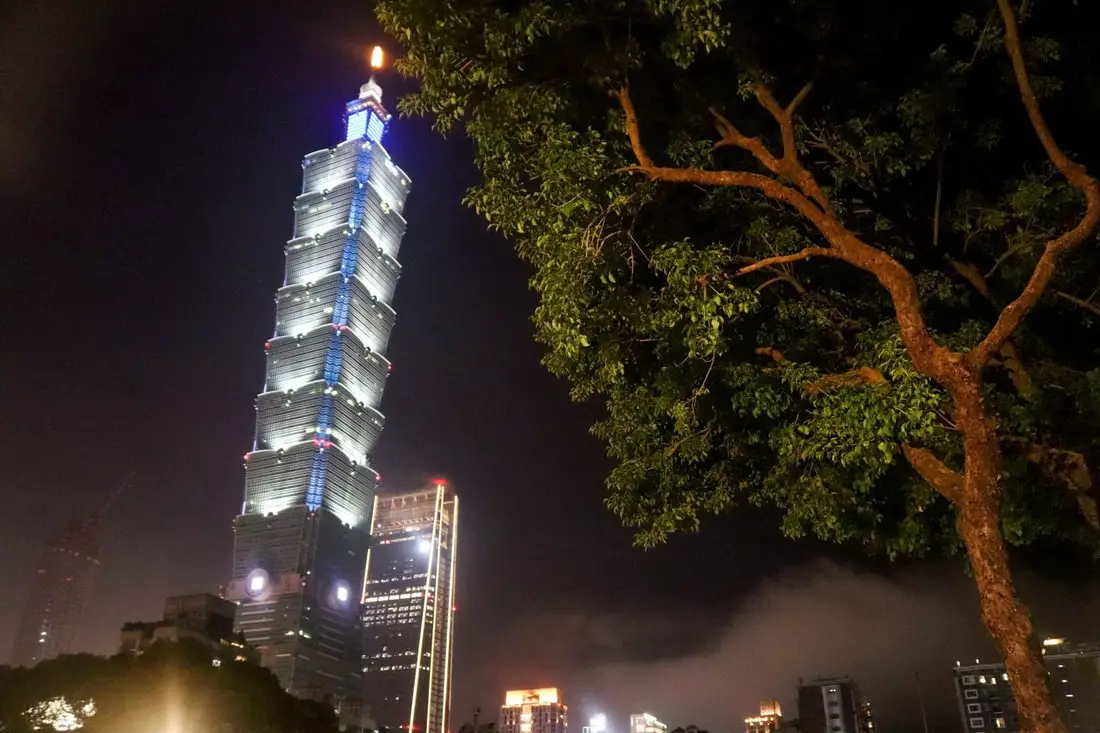
The Taipei 101 (aka Taipei World Financial Center) is the tallest building in Taiwan, standing at a height of 509 meters. It was the tallest building in the world from 2004 to 2010 and is now the 11th tallest building in the world as of 2023. It stands as an icon and symbol of Taiwan's economic prosperity and may be the most recognizable building in Taiwan. It also features observatories on the 89th, 91st, and 101st floors with some of the best views of Taipei.
Taipei 101 Q + A: What is the Taipei 101? It was the tallest building in the world from 2004-2010, with 101 floors above ground (hence the name 101) and 5 floors below ground. It was designed by C.Y. Lee & Partners, and also had the fastest elevator in the world until 2016. It is an icon of Taiwan technological advancement. How was Taipei 101 built? The Taipei 101 was built in a period of 5 years from 1999-2004. The Taipei 101 is reinforced by concrete piles driven 80 meters below the ground and 30 meters into bedrock. In addition, it is made of high-strength reinforced steel and flexible materials. It was designed by C.Y. Lee & Partners and also had the fastest elevator in the world until 2016. How much did the Taipei 101 cost? NT$ 58 billion (US$1.934 billion) How is the Taipei 101 earthquake proof? How does the Taipei 101 withstand earthquakes? The Taipei 101 is reinforced by concrete piles driven 80 meters below the ground and 30 meters into bedrock. In addition, it is made of high-strength reinforced steel and flexible materials. How does the Taipei 101 damper work? The damper works by offsetting strong wind gusts, absorbing the forces, and turning them into kinetic energy, moving the damper. How much does the Taipei 101 sway? The most that the Taipei 101 damper has ever swayed was during Typhoon Soudelor, swaying 100 centimeters (39 in). See below for a video! Hours: The Taipei 101 Observatory is open every day from 9 AM to 10 PM. When to go: In my opinion, the best time to go is on a sunny morning just after it has rained so that there is no haze in the air. Price: 88, 89, and 91, observatory floors: 600 NT (20 USD) per person. You can book a discount ticket on TripAdvisor here, Klook here, or KKday here. 101st-floor "Skyline 460" observation deck (in addition to 88, 89, and 91 floors): 3000 NT (100 USD) per person. You can book a discount ticket on Klook here. You can book tours to the Taipei 101 such as 101 Top Floor Tour and Dinner at Din Tai Fung, Taipei 101 Observation Deck activity, or Din Tai Fung and Hot Spring Experience on TripAdvisor here or Klook here. Hotels in Taipei: High end: We have stayed at and recommend the Yuanshan Grand Hotel, once the tallest building in Taiwan and still the most grand (book on Booking.com here, Tripadvisor here, or Agoda here). We have also stayed at and recommend the Grand Hyatt (book on Booking.com here, Tripadvisor here, Agoda here, or Hotels.com here), Marriot (book on Booking.com here, Tripadvisor here, Agoda here, or Hotels.com here), Sheraton (book on Booking.com here, Tripadvisor here, Agoda here, or Hotels.com here), Shangri-la (book on Booking.com here, Tripadvisor here, Agoda here, or Hotels.com here), and Regent (book on Booking.com here, Tripadvisor here, Agoda here, or Hotels.com here), which are all very high quality hotels in the middle of Taipei City. We also recommend Fullon Hotel which has locations in Tamsui and Fulong near the beach (book on Booking.com here, Tripadvisor here, Agoda here, or Hotels.com here). Budget Hotels: We have also stayed at and recommend Fu Chang Hotel in Ximending, which is within walking distance of Ximending shopping district (book on Booking.com here, Tripadvisor here, or Agoda here). We have also stayed at and recommend Hai Xia Your Home which is right in front of Fulong Beach (book on Booking.com here, Tripadvisor here, Agoda here, or Hotels.com here). Looking for a hotel? We recommend booking through Booking.com here, which provides the best quality selection of accommodation in Taiwan. Find out where to stay in our Taiwan hotels guide or search for the best hotel deals in Taiwan here. Just to let you know, if you book using the links above, we get some commission at no cost to you, and you can help support our blog. Some of the Klook links may not work if you are using an Ad blocker. You can click here to receive $5 USD on your first Klook purchase. How to get there: Take the MRT red line to the Taipei 101/World Trade Center station. There is limited paid parking nearby. By MRT: (Mass Rapid Transit, Metro train, subway) – Easily gets you around Taipei and Kaohsiung. You can also book an MRT travel pass on Klook here. By Taxi: You can take short rides for about 150 NT, or hire a Taxi for a day for around 150 USD. By Car: If you are looking for car rentals, you can also search Qeeq here, Klook here, or KKday here. You can also check out our car rental guide here. By Scooter: Looking for scooter rental in Taipei? You can search on Klook here or KKday here to search for options. You can also check out our scooter rental guide here. By Bicycle: Cycling is the best way to enjoy Taiwan's landscapes if you have the time and energy. Looking for bicycle rentals in Taiwan? You can use Taiwan's many Youbike sharing stations, or search for rentals on KKday here, and search for tours on Klook here. You can also check out our Taiwan cycling guide here. You can also book a Sunset Riverside Bike Ride and Historical Tour, 4 Hour Cycling in Taipei, Ultimate 8-Hour Cycling City Tour, or Taipei City Bike Tour with Night Market Experience on TripAdvisor here. For more information, check out our Taiwan transportation guide here. Map: 
Dihua Street is Taipei City's biggest and oldest Old Street. Here you can find a large area with historical buildings and unique old-style shops. Also, there are many art spaces, museums, and restaurants to explore in the area. You should definitely make a stop in this historically rich area on your trip to Taipei.
Historical Background: The land that Dadaocheng (aka Twatutia in Taiwanese 大稻埕) stands on was once part of Basay tribal land. The Basay people had lived on the land for thousands of years before the first Chinese settlers. Sections of Dadaocheng indicate that there were settlements here during the Dutch rule in the 1600s. The first Chinese settlers came to the area in the mid-1800's during the Qing Dynasty. They created a public area for drying rice and grain, called Dadaocheng (大稻埕) from which the place gets its name, which also became the central market in the area. The earliest trading shops were built in 1851, mainly selling rice, sugar, camphor, and tea. Dihua Street (迪化街), or center street (中街) was created around this time, making it the oldest street in Taipei. In 1859 the City God Temple was completed, the religious center of the area, and many streets sprouted out of the area. Most of the buildings were one story and made of red brick in Fujian style, and later western style houses were built. In 1891, the first train connecting Keelung and Taipei was completed. In 1902, Dadaocheng station was completed on the Tamsui Railway line. Tea and rice were the major exports from Dadaocheng during the Japanese era. After WWII, the main street, known as Center Street (中街) was changed to Dihua Street, to remember Dihua City in Xinjiang. Dihua Street is an important place to buy traditional food supplies and ingredients. It is particularly popular during Chinese festivals. Hours: About 9 AM to 7 PM. Price: Free Tours: You can book a walking tour of Dihua Street on TripAdvisor here, Klook here, or KKday here. You can also book a Changing Cheongsam Tour at Dadaocheng on TripAdvisor here. There are many tours of Dihua Street, Dadaocheng, and other spots in Taipei available on Klook here or KKday here. Hotels in Taipei: High end: We have stayed at and recommend the Yuanshan Grand Hotel, once the tallest building in Taiwan and still the most grand (book on Booking.com here, Tripadvisor here, or Agoda here). We have also stayed at and recommend the Grand Hyatt (book on Booking.com here, Tripadvisor here, Agoda here, or Hotels.com here), Marriot (book on Booking.com here, Tripadvisor here, Agoda here, or Hotels.com here), Sheraton (book on Booking.com here, Tripadvisor here, Agoda here, or Hotels.com here), Shangri-la (book on Booking.com here, Tripadvisor here, Agoda here, or Hotels.com here), and Regent (book on Booking.com here, Tripadvisor here, Agoda here, or Hotels.com here), which are all very high quality hotels in the middle of Taipei City. We also recommend Fullon Hotel which has locations in Tamsui and Fulong near the beach (book on Booking.com here, Tripadvisor here, Agoda here, or Hotels.com here). Budget Hotels: We have also stayed at and recommend Fu Chang Hotel in Ximending, which is within walking distance of Ximending shopping district (book on Booking.com here, Tripadvisor here, or Agoda here). We have also stayed at and recommend Hai Xia Your Home which is right in front of Fulong Beach (book on Booking.com here, Tripadvisor here, Agoda here, or Hotels.com here). Looking for a hotel? We recommend booking through Booking.com here, which provides the best quality selection of accommodation in Taiwan. Find out where to stay in our Taiwan hotels guide or search for the best hotel deals in Taiwan here. Just to let you know, if you book using the links above, we get some commission at no cost to you, and you can help support our blog. Some of the Klook links may not work if you are using an Ad blocker. You can click here to receive $5 USD on your first Klook purchase. How to get there: By MRT: From Beimen MRT station, walk north to Tacheng Street. Keep going until the street becomes Dihua Street (about 500 meters). You can purchase a discount easy card to use on the MRT from Klook here or KKday here. You can also book an MRT travel pass on Klook here. By Car/Scooter: Take Shimin Blvd. west to Tacheng Street. Keep going until the street becomes Dihua Street (about 500 meters). There is paid car parking on Shimin Blvd. Looking for scooter rental in Taipei? You can search on Klook here or KKday here to search for options. You can also check out our scooter rental guide here. If you are looking for car rentals, you can also search Qeeq here, Klook here, or KKday here. You can also check out our car rental guide here. By Bicycle: Cycling is the best way to enjoy Taiwan's landscapes if you have the time and energy. Looking for bicycle rentals in Taiwan? You can use Taiwan's many Youbike sharing stations, or search for rentals on KKday here, and search for tours on Klook here. You can also check out our Taiwan cycling guide here. You can also book a Sunset Riverside Bike Ride and Historical Tour, 4 Hour Cycling in Taipei, Ultimate 8-Hour Cycling City Tour, or Taipei City Bike Tour with Night Market Experience on TripAdvisor here. For more information, check out our Taiwan transportation guide here. Map: Please see below: 
Nangang District of Taipei City is quieter and less busy than nearby Xinyi District, but here you can find a relaxed atmosphere with beautiful mountains, historic buildings, museums, fun parks, great food, and a lack of crowds. Currently, Nangang is being turned into Taipei's "next Xinyi District" and is the new artistic and cultural heart of Taipei. It is definitely worth a stop on your next trip to Taipei.
Background: Nangang 南港means “South Port” in Chinese. This south port once rested on the southern banks of the Keelung River near what is now the Neihu MRT depot in Nangang District, Taipei. There was a "North Port" on the Keelung River in what is now Xizhi. Nangang Station was built in 1891 as part of the first railway in Taiwan, connecting Keelung to Taipei, making it a prime location for industry. Nangang's old street sprung up near the train station. Technically the oldest street in Nangang is "Zhongnan Street" which most people refer to when they say Nangang Old Street, but I think the old street also spreads onto Nangang Road and Academia Sinica Road. Nangang was once part of Neihu District before it split in the ROC era. In the earliest times, Nangang was known as an industry hub for coal, brick making, and tea farming. In order to ship goods from Neihu to Nangang rail station, at least two suspension bridges were made across the Keelung River. In the ROC era, Nangang was also an industrial hub for car parts especially the Nankang Tire Factory, which still makes tires today. Nangang has a population of about 113,000 people with about 5,200 people per square kilometer, and has the smallest population of any district of Taipei. Currently, Nangang is being turned into Taipei's "next Xinyi District" and is the new artistic and cultural heart of Taipei. Tours: You can book a tour of Taipei on Tripadvisor here, KKday here or Klook here. Where to stay: High end: We have stayed at and recommend the Nangang Marriott (book on Booking.com here or Agoda here). We have also stayed at and recommend the Yuanshan Grand Hotel, once the tallest building in Taiwan and still the most grand (book on Booking.com here or Agoda here). Looking for a hotel? We recommend booking through Booking.com here, which provides the best quality selection of accommodation in Taiwan. Find out where to stay in our Taiwan hotels guide or search for the best hotel deals in Taiwan here. How to get there: By Car/Scooter: The old street I would say stretches in front of Nangang Train Station on Nangang Road and then loops over to Zhongnan Street near where Zhongxiao East Road Ends. There is paid parking nearby. Looking for scooter rental in Taipei? You can search on Klook here or KKday here to search for options. You can also check out our scooter rental guide here. If you are looking for car rentals, you can also search Qeeq here, Klook here, or KKday here. You can also check out our car rental guide here. By Bus/MRT: The old street I would say stretches in front of Nangang Train Station on Nangang Road and then loops over to Zhongnan Street near where Zhongxiao East Road Ends. You can purchase a discount easy card to use on the MRT from Klook here or KKday here. You can also book an MRT travel pass on Klook here. By Bicycle: Cycling is the best way to enjoy Taiwan's landscapes if you have the time and energy. Looking for bicycle rentals in Taiwan? You can use Taiwan's many Youbike sharing stations, or search for rentals on KKday here, and search for tours on Klook here. You can also check out our Taiwan cycling guide here. You can also book a Sunset Riverside Bike Ride and Historical Tour, 4 Hour Cycling in Taipei, Ultimate 8-Hour Cycling City Tour, or Taipei City Bike Tour with Night Market Experience on TripAdvisor here. For more information, check out our Taiwan transportation guide here. Map: Please see below: 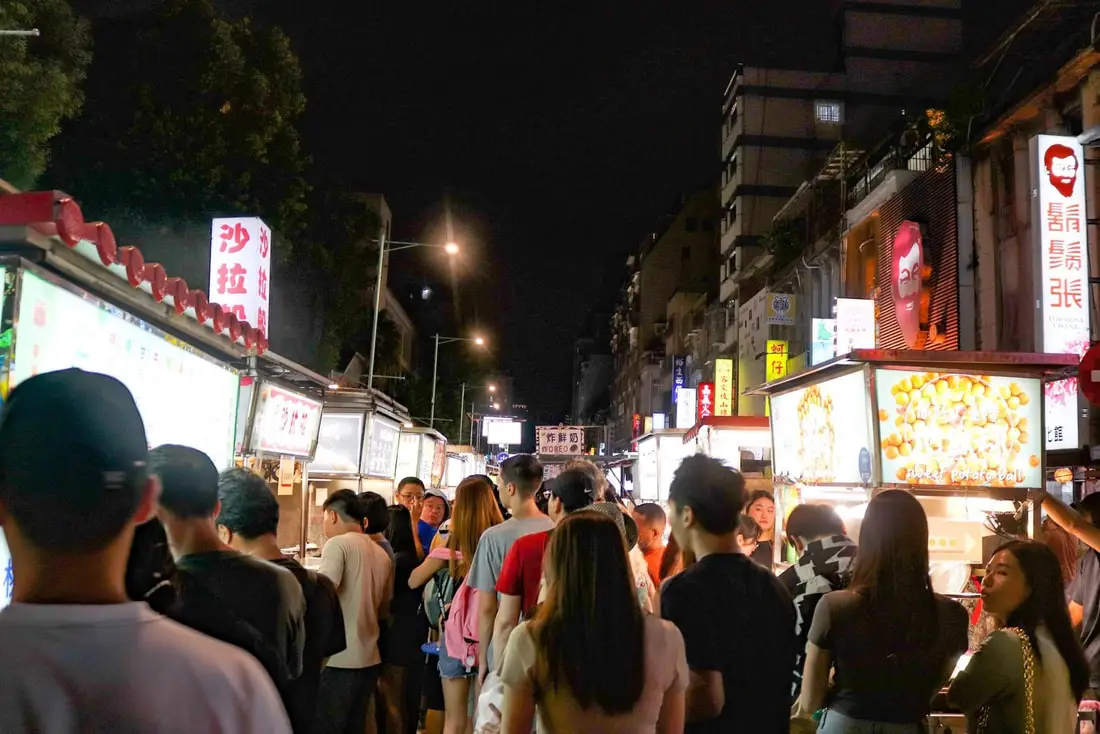
Ningxia Night Market is one of the most popular night markets in Taipei. The night market takes up two city blocks and includes food stalls as well as sit-down areas and restaurants. Popular delicacies here include Oyster Omelet, fried chicken, fried squid, and much more. The night market is also very close to the Dadaocheng historical area and is often considered to be a part of it. It is definitely worth a stop on your next trip to Taipei.
Historical Background: Ningxia Night Market began as a few food stalls on on the Jiancheng Roundabout (建成圓環) on Chongqing North Road, not long after the Danshui Railway Line was built in 1908. It was the most popular night market in Taipei during the Japanese Era. After the ROC took control of Taiwan, it continued to be a popular night market known for great food and cheap prices. After Chongqing North Road was widened in 1973, most of the stalls moved north to either side of Ningxia Road. Ningxia Road was refurbished in 2006 making it more sanitary and environmentally friendly. In 2015, it was named the best night market for shopping, the friendliest night market, the most charismatic night market, the most environmentally conscious night market, and the best-tasting night market in Taipei. As for the roundabout, the local government saw it as a run-down area with lots of illegal stalls. There were also two large fires there in 1993 and 1998. In 2002, then Taipei Mayor Ma Yingjeou tore down the old roundabout and built a glass restaurant area in its place. However, restaurant owners found that the new building was poorly designed and bad for business, and the popular restaurants moved out. Later on, in 2008 the area was rebuilt again, but there was a scandal involving how the area was rented, and so the area shut down in 2011. In 2016, the roundabout was made into a park. Hours: Open from 5 PM until 1 AM, every night. Tours: You can book a food tour of Ningxia Night Market on Klook here or TripAdvisor here. Hotels in Taipei: We have stayed at and recommend the Yuanshan Grand Hotel, once the tallest building in Taiwan and still the most grand (book on Booking.com here or Agoda here). We also recommend Fullon Hotel which has locations in Tamsui and Fulong near the beach (book on Booking.com here or Agoda here). Budget Hotels: We have stayed at and also recommend Fu Chang Hotel in Ximending, which is within walking distance of Ximending shopping district (book on Booking.com here or Agoda here). We have also stayed at and recommend Hai Xia Your Home which is right in front of Fulong Beach (book on Booking.com here or Agoda here). Looking for a hotel? We recommend booking through Booking.com here, which provides the best quality selection of accommodation in Taiwan. Find out where to stay in our Taiwan hotels guide or search for the best hotel deals in Taiwan here. How to get there: By MRT: Take the Red Line to Shuanglian Station and then take exit 1 or 2 west out of the station. The night market is about two blocks down the road. You can also book an MRT travel pass on Klook here. By Scooter: Take Chongqing North Road in central Taipei until you reach Ningxia Road. You can park on the side of the road near Ningxia Road. Looking for scooter rental in Taipei? You can search on Klook here or KKday here to search for options. You can also check out our scooter rental guide here. By Car: Take Chongqing North Road in central Taipei until you reach Ningxia Road. You can park on the side of the road near Ningxia Road. There are some paid parking garages around the night market. If you are looking for car rentals, you can also search Qeeq here, Klook here, or KKday here. You can also check out our car rental guide here. By Bicycle: Cycling is the best way to enjoy Taiwan's landscapes if you have the time and energy. Looking for bicycle rentals in Taiwan? You can use Taiwan's many Youbike sharing stations, or search for rentals on KKday here, and search for tours on Klook here. You can also check out our Taiwan cycling guide here. You can also book a Sunset Riverside Bike Ride and Historical Tour, 4 Hour Cycling in Taipei, Ultimate 8-Hour Cycling City Tour, or Taipei City Bike Tour with Night Market Experience on TripAdvisor here. For more information, check out our Taiwan transportation guide here. Map: See below: 
Shiding District is a secret mountain paradise in New Taipei City, in northern Taiwan (新北市石碇區). Lots of people simply pass through here without knowing much about what there is to see. In this guide I will show you some of the secret historical and nature destinations in this amazing place.
Historical Background: The name Shiding comes from boats transporting goods from the area that used to use large rocks (shi 石) in the river as anchors (ding 碇). The Shiding administrative area (石碇堡) was created during the Qing Dynasty and extended from Keelung to Wenshan District. The area around Shiding Old Street was the first area to be developed by Han Chinese in Shiding. In the early days during the Qing Dynasty, the Han Chinese settlers here mainly grew tea and leeks. During the Qing Dynasty, Shiding was an important stop along the Danlan Old Trail (淡蘭古道 which means the road between Tamsui and Yilan), which was split into three paths, and Shiding was on the Southern Path. The Southern Path winded from Mengjia Old Street to Liuzhangli, then to Shengkeng, and onto Shiding which was a major tea producer at the time. From Shiding, the road then went to Pinglin and then Yilan. The Southern path was the quickest way to Yilan. During the Japanese Era until the 1980s, the major industry in the area was coal mining, As the coal mining industry winded down in the 1980s and 90s in Taiwan due to lower worldwide coal prices, the economy in Shiding suffered and many people left. The multi story buildings near Shiding Old street are a testament to the economic prosperity of the coal mining era. Currently Shiding is sparsely populated with the main economic activity including tea farming and agriculture. Tours of Shiding: You can book a tour to Shiding on TripAdvisor here, Klook here, or KKday here. Hotels in Taipei: We have stayed at and recommend the Yuanshan Grand Hotel, once the tallest building in Taiwan and still the most grand (book on Booking.com here, Tripadvisor here, or Agoda here). We have stayed at and also recommend Fu Chang Hotel in Ximending, which is within walking distance of Ximending shopping district (book on Booking.com here, Tripadvisor here, or Agoda here). Looking for a hotel? We recommend booking through Booking.com here, which provides the best quality selection of accommodation in Taiwan. Find out where to stay in our Taiwan hotels guide or search for the best hotel deals in Taiwan here. How to get there: By Car: Go east on National Freeway 5, then get off at the Shiding interchange. Continue east until you reach Shiding Old Street. If you are looking for car rentals, you can also search Qeeq here, Klook here, or KKday here. You can also check out our car rental guide here. By Scooter: From Taipei, take highway 106 east from Shenkeng toward Shiding, pass through Shiding Bao Tunnel, and soon you will come to Shiding Old Street. Looking for scooter rental in Taipei? You can search on Klook here or KKday here to search for options. You can also check out our scooter rental guide here. By Bus: From Taipei City Call MRT station, you can take bus 912 to Shiding High School, after that you will have to switch to bus 666 which will take you all the way to the old street (total about 40 minutes). You can also book tickets to travel to Shiding via inter-city bus on Klook here. You can also book a Taipei Sightseeing: Hop On, Hop Off Open Top Bus on TripAdvisor here. By Bicycle: Cycling is the best way to enjoy Taiwan's landscapes if you have the time and energy. Looking for bicycle rentals in Taiwan? You can use Taiwan's many Youbike sharing stations, or search for rentals on KKday here, and search for tours on Klook here. You can also check out our Taiwan cycling guide here. You can also book a Sunset Riverside Bike Ride and Historical Tour, 4 Hour Cycling in Taipei, Ultimate 8-Hour Cycling City Tour, or Taipei City Bike Tour with Night Market Experience on TripAdvisor here. For more information, check out our Taiwan transportation guide here. Map: 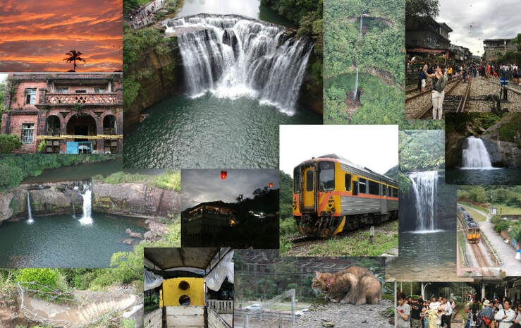
Pingxi District of New Taipei has some of the most popular attractions in Northern Taiwan. With a total of 7 stations along the Pingxi Railway Line (plus 2 if you count Ruifang and Houtong), there are endless places to explore, eat, hike, and enjoy Taiwan's history, culture, and natural beauty all in one place.
Background: Before the Pingxi Railway was built, during the Qing Dynasty a section of the Danlan Old Trail ran through roughly the same area, connecting Yilan to Tamsui. The Japanese completed the Pingxi Railway in 1921 in order to transport coal from the area. Most all of the stations and villages along the line were economically reliant on the coal industry until its downfall in the late 1990s. The coal industry remained strong after the ROC took over Taiwan after WWII, but slowly waned in the 1980s and 1990s due to the decrease in global coal prices. In the year 2000, Sanxia’s Lifeng Mine shut down operations, and Taiwan’s mining company closed, and thus all coal mining in Taiwan effectively stopped. The Pingxi Railway is a single track that is 12.9 KM long with 7 stations. Recently the government has offered many plans to connect the Pingxi Railway to the Taipei MRT via Jingtong to Jingmei, however due to many factors these plans have never been approved. The area around Pingxi and Ruifang is made up of sedimentary rock which easily erodes, creating many large waterfalls such as Shifen Falls, and pointy jagged peaks like the Pingxi Crags. Popular activities along the Pingxi Railway include hiking, river tracing, eating at one of the many old streets, setting off sky lanterns, and exploring the many historical coal mining sites. Hours: The first train reaches Sandiaoling daily at 5:25 AM and the last train leaves Jingtong at 8:33 PM. Price: 80 NT per person for a one day pass. Book tickets via the normal train (TRA) on Klook here. You can purchase a discount easy card to use on Pingxi Railway Line on Klook here or KKday here. You can also book a travel pass on Klook here. When to go: Any time of year is great. However, waterfalls are most enjoyable during the hot summer, and you may want to come for the Lantern Festival when hundreds of sky lanterns are set off at once. To avoid crowds and packed trains, do not go on weekends or holidays. Tours of Pingxi: There are many tour itineraries that you can enjoy in Shifen that will take you to multiple destinations and arrange transportation. For more information, you can check out Tripadvisor here, KKday here or Klook here, which are both great tour websites that can connect you with the right tour and tour guide for you. Here are some of the most popular tours of Pingxi:
Activities Around Pingxi: Don't forget that there are many activities available around Pingxi such as Rock Climbing, Hiking, kayaking, canoeing, snorkeling, SUP / paddle boarding, water biking, Diving, River Tracing / Canyoneering, ATVing, Horse Riding, Cooking Class, photo shoot, Jingtong Sky Lantern Police Station, Shifen Sky Lantern Experience, Waterfall Zipline, Waterfall Diving, and more on Tripadvisor here, Klook here, or KKday here. Hotels on Taiwan's Northern Coast: We recommend Fullon Hotel which has locations in Tamsui and Fulong near the beach (book on Booking.com here, Tripadvisor here, Agoda here, or Hotels.com here). We have stayed at and recommend Gold Mountain Ranch, which is a horse ranch and glamping destination in Jinshan. You can book a night at Gold Mountain Ranch on Klook here. You can also check out our full blog on the ranch here. We have also stayed at and recommend Hai Xia Your Home which is right in front of Fulong Beach (book on Booking.com here, Tripadvisor here, Agoda here, or Hotels.com here). Looking for a hotel? We recommend booking through Booking.com here, which provides the best quality selection of accommodation in Taiwan. Find out where to stay in our Taiwan hotels guide or search for the best hotel deals in Taiwan here. How to get there: By Train: Take the TRA to Ruifang Station, buy the Pingxi Railway line one day pass, and then switch to the Pingxi Railway line. Get off at any station! Book tickets via the normal train (TRA) on Klook here. You can purchase a discount easy card to use on Pingxi Railway Line on Klook here or KKday here. You can also book a travel pass on Klook here. By Car/Scooter: Take Provincial Highway 2 east toward Pinglin, then get off the main highway once you reach Shifen. You can drive right or left to reach all of the stations on the Pingxi Railway line. But please know there is limited car parking around the stations. If you are looking for car rentals, you can also search Qeeq here, Klook here, or KKday here. You can also check out our car rental guide here. Looking for scooter rental in Taipei? You can search on Klook here or KKday here to search for options. You can also check out our scooter rental guide here. By Taxi: You can take short rides for about 150 NT, or hire a Taxi for a day for around 150 USD on Klook here. By Bus: You can also book tickets to travel to Shifen via inter-city bus on Klook here. You can also book a Taipei Sightseeing: Hop On, Hop Off Open Top Bus on TripAdvisor here. By Bicycle: Cycling is the best way to enjoy Taiwan's landscapes if you have the time and energy. Looking for bicycle rentals in Taiwan? You can use Taiwan's many Youbike sharing stations, or search for rentals on KKday here, and search for tours on Klook here. You can also check out our Taiwan cycling guide here. You can also book a Sunset Riverside Bike Ride and Historical Tour, 4 Hour Cycling in Taipei, Ultimate 8-Hour Cycling City Tour, or Taipei City Bike Tour with Night Market Experience on TripAdvisor here. For more information, check out our Taiwan transportation guide here. Map: Please see below: 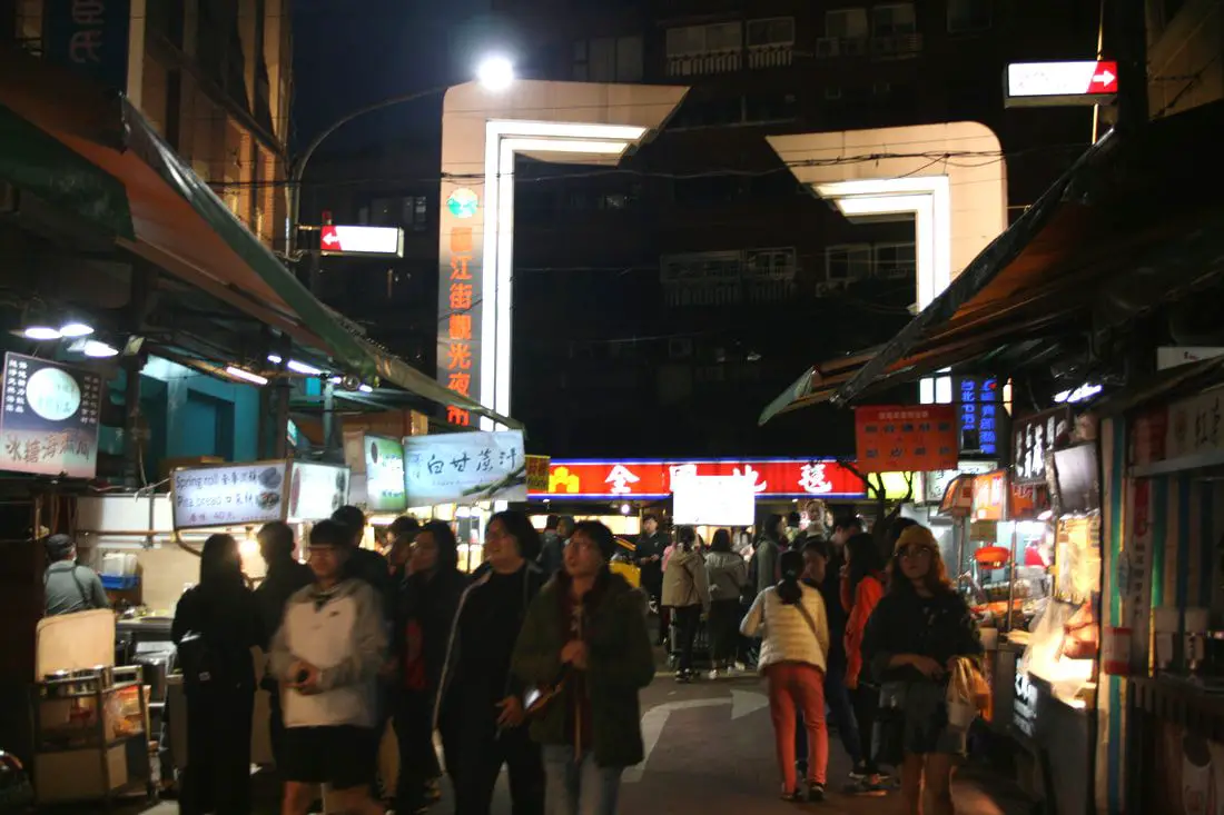
Tonghua Street Night Market (aka Linjiang Street Night Market) is a large night market in Da'an District of Taipei City. It's not as touristy as other night markets in Taipei, and you can find almost anything to eat here, along with cheap clothes and accessories. If you want to experience an authentic night market experience while in Taipei, Tonghua is the place to go.
Background: Before1964, the area known as Tonghua Night Market was just rice paddies. In 1965, a military dependents village was built on Tonghua Street. In 1979, Linjiang Street was created as an asphalt road, and has since become what we know today as Tonghua Street Night Market. The name of the night market was officially changed to Linjiang Street Tourist Night Market (臨江街觀光夜市) in 2001. The night market sits between Tonghua Street and Keelung Road. It is roughly 300 meters long and has over200 food stalls. Popular foods that the night market is known for include dry noodles, oyster omlettes, suasages, brazed meat, among others. With competition from Raohe Street, Shihlin Night Market, Ximending, and Ningxia Night Market, not as many foreign tourists end up visiting Tonghua Street. Hours: Roughly 6:00 PM to Midnight. Tours: You can buy Tonghua Night Market food pass on Klook here. You can also book a Private Street Food Tour of Taipei on TripAdvisor here. For more information, you can check out Tripadvisor here, KKday here or Klook here, which are both great tour websites that can connect you with the right tour and tour guide for you. Hotels in Taipei: We have stayed at and recommend the Yuanshan Grand Hotel, once the tallest building in Taiwan and still the most grand (book on Booking.com here, Tripadvisor here, or Agoda here). We have stayed at and also recommend Fu Chang Hotel in Ximending, which is within walking distance of Ximending shopping district (book on Booking.com here, Tripadvisor here, or Agoda here). Looking for a hotel? We recommend booking through Booking.com here, which provides the best quality selection of accommodation in Taiwan. Find out where to stay in our Taiwan hotels guide or search for the best hotel deals in Taiwan here. How to get there: By MRT: Take the red line to Xinyi Anhe Station, then get off at exit 3, then take a left down Toinghua Street for four blocks until you reach Linjiang Street, the entrance to the night market. You can also book an MRT travel pass on Klook here. By car/scooter: Go East on Xinyi Road and then turn right on Tonghua Street until you come to Linjiang Street. There is some scooter parking on Tonghua Street and in the alleys, but for a car you need to park in a nearby parking lot or garage. Looking for scooter rental in Taipei? You can search on Klook here or KKday here to search for options. You can also check out our scooter rental guide here. If you are looking for car rentals, you can also search Qeeq here, Klook here, or KKday here. You can also check out our car rental guide here. By Bicycle: Cycling is the best way to enjoy Taiwan's landscapes if you have the time and energy. Looking for bicycle rentals in Taiwan? You can use Taiwan's many Youbike sharing stations, or search for rentals on KKday here, and search for tours on Klook here. You can also check out our Taiwan cycling guide here. You can also book a Sunset Riverside Bike Ride and Historical Tour, 4 Hour Cycling in Taipei, Ultimate 8-Hour Cycling City Tour, or Taipei City Bike Tour with Night Market Experience on TripAdvisor here. For more information, check out our Taiwan transportation guide here. Map: Please see below: 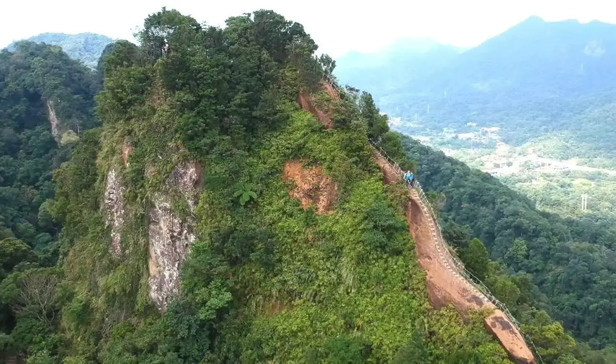
Taipei is full of very accessible hikes right next to the city center. You can find amazing views of Taipei City, as well as make some adrenaline pumping hikes up some very steep peaks in New Taipei and Keelung. We highly recommend checking out what hikes Taipei has to offer. In this guide, we will list out some of the most amazing hikes around Taipei.
Safety Tips When Hiking in Taipei:
Basic Taipei Travel Tips:
When should you go to Taipei? In my opinion, the best weather in Taipei is from March-May, and October - November, when the temperatures stay around 26 degrees Celsius and there is not as much rain. Summers are also nice, with the most sunny weather, but also hot and rainy. Winters can be cold (but not below freezing) and usually wet. Overall, there is no wrong answer as to what time of year you should visit Taipei. You will have a great time here at any time of year. Hotels in Taipei: High end: We have stayed at and recommend the Yuanshan Grand Hotel, once the tallest building in Taiwan and still the most grand (book on Booking.com here, Tripadvisor here, or Agoda here). We have also stayed at and recommend the Grand Hyatt (book on Booking.com here, Tripadvisor here, Agoda here, or Hotels.com here), Marriot (book on Booking.com here, Tripadvisor here, Agoda here, or Hotels.com here), Sheraton (book on Booking.com here, Tripadvisor here, Agoda here, or Hotels.com here), Shangri-la (book on Booking.com here, Tripadvisor here, Agoda here, or Hotels.com here), and Regent (book on Booking.com here, Tripadvisor here, Agoda here, or Hotels.com here), which are all very high quality hotels in the middle of Taipei City. We also recommend Fullon Hotel which has locations in Tamsui and Fulong near the beach (book on Booking.com here, Tripadvisor here, Agoda here, or Hotels.com here). Budget Hotels: We have stayed at and recommend and also Fu Chang Hotel in Ximending, which is within walking distance of Ximending shopping district (book on Booking.com here, Tripadvisor here, or Agoda here). We have also stayed at and recommend Hai Xia Your Home which is right in front of Fulong Beach (book on Booking.com here, Tripadvisor here, Agoda here, or Hotels.com here). Looking for a hotel? We recommend booking through Booking.com here, which provides the best quality selection of accommodation in Taiwan. Find out where to stay in our Taiwan hotels guide or search for the best hotel deals in Taiwan here. Tours in Taipei: There are many tour itineraries that you can enjoy in Taipei that will take you to multiple destinations and arrange transportation. For more information, you can check out Tripadvisor here, KKday here or Klook here, which are both great tour websites that can connect you with the right tour and tour guide for you. Here are some of the post popular tours of Taipei on Tripadvisor:
Attractions in Taipei: There are many attractions that you can enjoy in Taipei such as Taipei 101 Observatory, Taipei 101 460 Skyline Observatory, Taipei Children's Amusement Park, Maokong Gondola, National Palace Museum, Yehliu Ocean World, Yehliu Geopark, National Museum of Marine Science and Biology, i-ride 5D cinema, Astronomical Museum, Miniatures Museum of Taiwan, Double Decker Sightseeing Bus, Miramar Ferris Wheel Ticket, Taipei Zoo, Heping Island Park, Ju Ming Museum, Yuanshan Hotel Secret Road, National Taiwan Museum, New Taipei Gold Museum, Futian Leisure Farm, Chiang Kai-shek Shilin Residence, Chi Po-lin Museaum, Beitou Museum, Tsao Wonderland, Railway Museum, Fort San Domingo, 13 Levels Archaeology Museum, Austin Land, Museum of World Religions, Formosan Aboriginies Museum, ASE Parent-child Park, teamLab Future Park, Yukids Island, VR Experience, Bat Cave, Neidong Waterfall, Candlestick Islet, Jurassic Snow Park, Zhonghe High5 Amusement Park, Longshan Temple, Xingtian Temple, Ningxia Night Market, Yansan Night Market, Meteor Garden, Yingge Old Street, and many more attractions on Tripadvisor here, Klook here, or KKday here. Activities in Taipei: Indoor Skiing, Rock Climbing, Hiking, Wakeboarding, Surfing, Speedboat Surfing, SUP / Paddle Boarding, Diving, Snorkeling Kayaking, Canoeing, Water Biking, River Tracing / Canyoneering, ATVing, Horse Riding, Cooking Class, Archery, Ice Skating, Roller Skating, Tree Climbing, Urban Camping, Glamping, Motorcycling, Motorbike Tour, Dragon Boat Racing, Escape Room, Shen'ao Rail Bike, Laser Gun Experience, Batting Cages, Bowling, Paintball, Flight Simulation Experience, Taipei Tram Driving Experience, Rail Simulation Experience, Taipei 101 Observation Deck activity, Strawberry Picking, Professional Photo Shoot, Body Relaxation SPA, Night Tour, Calligraphy Workshop rand more on Tripadvisor here, Klook here, or KKday here. Just to let you know, if you book using the links above, we get some commission at no cost to you, and you can help support our blog. Some of the Klook links may not work if you are using an Ad blocker. You can click here to receive $5 USD on your first Klook purchase. How to get there: The only way to get to Taiwan is via airplane. Planes leave daily from Taipei's Songshan and Toayuan Airport. Taoyuan Airport: Taoyuan is Taiwan's largest airport and typically has cheaper flights and more flight times to choose from. It's about an hour's journey from Taoyuan Airport to the center of Taipei. You can travel via MRT, HSR, bus, or taxi to get to Taipei. You can get 30% off the Taoyuan Airport VIP lounge on KKday here. Songshan Airport: Songshan is a small airport in Taipei's city center, and can be a convenient option for people traveling within Asia. The airport is right on the Taipei MRT brown line. You can book cheap flights to Taiwan on KKday here, Trip.com here, CheapO Air here, or Kiwi here. How to get around in Taipei: Taipei's transportation system is convenient and safe. There are many options you can consider to get around in Taipei below: By Train: Gets you to the city center of all major cities in Taiwan. It is about 800NT to get from Taipei to Kaohsiung. Roughly half the price of the HSR. Book tickets via the normal train (TRA) on Klook here. By HSR: (High-Speed Rail) – Gets you quickly from north to south. Besides Taipei and Kaohsiung, most of the stations are far from city centers. It costs about 1500NT to get from Taipei to Kaohsiung. You can book tickets to the high-speed rail (HSR) on Klook here or KKDay here. By MRT: (Mass Rapid Transit, Metro train, subway) – Easily gets you around Taipei and Kaohsiung. You can also book an MRT travel pass on Klook here. By Bus: Buses can be tricky. Long-range buses such as Ubus and King Bus are easier to understand and cheaper than the local train. They can take you to the city center of every city throughout Taiwan and to remote tourist destinations such as sun moon lake. A long-range bus from Taipei to Kaohsiung is about 500 NT. You can also book tickets to travel to Shifen via inter-city bus on Klook here. You can also book a Taipei Sightseeing: Hop On, Hop Off Open Top Bus on TripAdvisor here. By Taxi: You can take short rides for about 150 NT, or hire a Taxi for a day for around 150 USD. By Car: If you are looking for car rentals, you can also search Qeeq here, Klook here, or KKday here. You can also check out our car rental guide here. By Scooter: Looking for scooter rental in Taipei? Click here or here to search for options. You can also check out our scooter rental guide here. By Bicycle: Cycling is the best way to enjoy Taiwan's landscapes if you have the time and energy. Looking for bicycle rentals in Taiwan? You can use Taiwan's many Youbike bike sharing stations, or search for rentals on KKday here, and search for tours on Klook here. You can also check out our Taiwan cycling guide here. You can also book a Sunset Riverside Bike Ride and Historical Tour, 4 Hour Cycling in Taipei, Ultimate 8-Hour Cycling City Tour, or Taipei City Bike Tour with Night Market Experience on TripAdvisor here. For more information, check out our Taiwan transportation guide here. Tourist Site Map: Check out our map below of tourist sites in Taiwan, which is constantly updated: 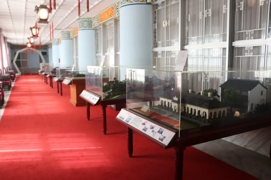
Taipei is full of some of the best museums in Taiwan. Besides the National Palace Museum, there are dozens of museums in Taipei that can provide you deeper insights into Taiwan's unique history and culture.
Brief Historical Background of Taipei: The land on which Taipei now stands on what was once part of Basay tribal land. The Basay people had lived on the land for thousands of years before the first Chinese settlers ever came. Chinese settlers from Fujian began living here during the Dutch rule in the 1600s. The first Chinese settlers came to the area in the mid-1800's during the Qing Dynasty. They created a public area for drying rice and grain, called Dadaocheng (大稻埕) which also became the central market in the area. The earliest trading shops were built in 1851, mainly selling rice, sugar, camphor, and tea. Dihua Street (迪化街) was created around this time, making it the oldest street in Taipei. Most of the buildings were one story and made of red brick in Fujian style, and later western style houses were built. The walls and gates of Taipei were completed in 1884. In 1891, the first train connecting Keelung and Taipei was completed. During the Japanese era, in 1904 the walls of Taipei were destroyed after less than 30 years, and Taipei was re-planned into the capital of Taiwan. After the ROC took control of Taiwan, Taipei continued as the capital city, as well as the financial hub of Taiwan. During the Taiwan miracle, many rural families moved from southern Taiwan to factories and offices in Taipei, making Taipei the most populous urban area in Taiwan. Currently, Taipei is the most advanced and affluent city in Taiwan. It also has Taiwan's most advanced public transportation system, making it easy for millions of commuters to live outside the city where rents are cheaper. Now, most of Taiwan's economic activity is based in this city. Basic Taipei Travel Tips:
When should you go to Taipei? In my opinion, the best weather in Taipei is from March-May, and October - November, when the temperatures stay around 26 degrees Celsius and there is not as much rain. Summers are also nice, with the most sunny weather, but also hot and rainy. Winters can be cold (but not below freezing) and usually wet. Overall, there is no wrong answer as to what time of year you should visit Taipei. You will have a great time here at any time of year. Hotels in Taipei: High end: We have stayed at and recommend the Yuanshan Grand Hotel, once the tallest building in Taiwan and still the most grand (book on Booking.com here, Tripadvisor here, or Agoda here). We have also stayed at and recommend the Grand Hyatt (book on Booking.com here, Tripadvisor here, Agoda here, or Hotels.com here), Marriot (book on Booking.com here, Tripadvisor here, Agoda here, or Hotels.com here), Sheraton (book on Booking.com here, Tripadvisor here, Agoda here, or Hotels.com here), Shangri-la (book on Booking.com here, Tripadvisor here, Agoda here, or Hotels.com here), and Regent (book on Booking.com here, Tripadvisor here, Agoda here, or Hotels.com here), which are all very high quality hotels in the middle of Taipei City. We also recommend Fullon Hotel which has locations in Tamsui and Fulong near the beach (book on Booking.com here, Tripadvisor here, Agoda here, or Hotels.com here). Budget Hotels: We have stayed at and recommend and also Fu Chang Hotel in Ximending, which is within walking distance of Ximending shopping district (book on Booking.com here, Tripadvisor here, or Agoda here). We have also stayed at and recommend Hai Xia Your Home which is right in front of Fulong Beach (book on Booking.com here, Tripadvisor here, Agoda here, or Hotels.com here). Looking for a hotel? We recommend booking through Booking.com here, which provides the best quality selection of accommodation in Taiwan. Find out where to stay in our Taiwan hotels guide or search for the best hotel deals in Taiwan here. Tours in Taipei: There are many tour itineraries that you can enjoy in Taipei that will take you to multiple destinations and arrange transportation. For more information, you can check out Tripadvisor here, KKday here or Klook here, which are both great tour websites that can connect you with the right tour and tour guide for you. Here are some of the post popular tours of Taipei on Tripadvisor:
Attractions in Taipei: There are many attractions that you can enjoy in Taipei such as Taipei 101 Observatory, Taipei 101 460 Skyline Observatory, Taipei Children's Amusement Park, Maokong Gondola, National Palace Museum, Yehliu Ocean World, Yehliu Geopark, National Museum of Marine Science and Biology, i-ride 5D cinema, Astronomical Museum, Miniatures Museum of Taiwan, Double Decker Sightseeing Bus, Miramar Ferris Wheel Ticket, Taipei Zoo, Heping Island Park, Ju Ming Museum, Yuanshan Hotel Secret Road, National Taiwan Museum, New Taipei Gold Museum, Futian Leisure Farm, Chiang Kai-shek Shilin Residence, Chi Po-lin Museaum, Beitou Museum, Tsao Wonderland, Railway Museum, Fort San Domingo, 13 Levels Archaeology Museum, Austin Land, Museum of World Religions, Formosan Aboriginies Museum, ASE Parent-child Park, teamLab Future Park, Yukids Island, VR Experience, Bat Cave, Neidong Waterfall, Candlestick Islet, Jurassic Snow Park, Zhonghe High5 Amusement Park, Longshan Temple, Xingtian Temple, Ningxia Night Market, Yansan Night Market, Meteor Garden, Yingge Old Street, and many more attractions on Tripadvisor here, Klook here, or KKday here. Activities in Taipei: Indoor Skiing, Rock Climbing, Hiking, Wakeboarding, Surfing, Speedboat Surfing, SUP / Paddle Boarding, Diving, Snorkeling Kayaking, Canoeing, Water Biking, River Tracing / Canyoneering, ATVing, Horse Riding, Cooking Class, Archery, Ice Skating, Roller Skating, Tree Climbing, Urban Camping, Glamping, Motorcycling, Motorbike Tour, Dragon Boat Racing, Escape Room, Shen'ao Rail Bike, Laser Gun Experience, Batting Cages, Bowling, Paintball, Flight Simulation Experience, Taipei Tram Driving Experience, Rail Simulation Experience, Taipei 101 Observation Deck activity, Strawberry Picking, Professional Photo Shoot, Body Relaxation SPA, Night Tour, Calligraphy Workshop rand more on Tripadvisor here, Klook here, or KKday here. Just to let you know, if you book using the links above, we get some commission at no cost to you, and you can help support our blog. Some of the Klook links may not work if you are using an Ad blocker. You can click here to receive $5 USD on your first Klook purchase. How to get there: The only way to get to Taiwan is via airplane. Planes leave daily from Taipei's Songshan and Toayuan Airport. Taoyuan Airport: Taoyuan is Taiwan's largest airport and typically has cheaper flights and more flight times to choose from. It's about an hour's journey from Taoyuan Airport to the center of Taipei. You can travel via MRT, HSR, bus, or taxi to get to Taipei. You can get 30% off the Taoyuan Airport VIP lounge on KKday here. Songshan Airport: Songshan is a small airport in Taipei's city center, and can be a convenient option for people traveling within Asia. The airport is right on the Taipei MRT brown line. You can book cheap flights to Taiwan on KKday here, Trip.com here, CheapO Air here, or Kiwi here. How to get around in Taipei: Taipei's transportation system is convenient and safe. There are many options you can consider to get around in Taipei below: By Train: Gets you to the city center of all major cities in Taiwan. It is about 800NT to get from Taipei to Kaohsiung. Roughly half the price of the HSR. Book tickets via the normal train (TRA) on Klook here. By HSR: (High-Speed Rail) – Gets you quickly from north to south. Besides Taipei and Kaohsiung, most of the stations are far from city centers. It costs about 1500NT to get from Taipei to Kaohsiung. You can book tickets to the high-speed rail (HSR) on Klook here or KKDay here. By MRT: (Mass Rapid Transit, Metro train, subway) – Easily gets you around Taipei and Kaohsiung. You can also book an MRT travel pass on Klook here. By Bus: Buses can be tricky. Long-range buses such as Ubus and King Bus are easier to understand and cheaper than the local train. They can take you to the city center of every city throughout Taiwan and to remote tourist destinations such as sun moon lake. A long-range bus from Taipei to Kaohsiung is about 500 NT. You can also book tickets to travel to Shifen via inter-city bus on Klook here. You can also book a Taipei Sightseeing: Hop On, Hop Off Open Top Bus on TripAdvisor here. By Taxi: You can take short rides for about 150 NT, or hire a Taxi for a day for around 150 USD. By Car: If you are looking for car rentals, you can also search Qeeq here, Klook here, or KKday here. You can also check out our car rental guide here. By Scooter: Looking for scooter rental in Taipei? Click here or here to search for options. You can also check out our scooter rental guide here. By Bicycle: Cycling is the best way to enjoy Taiwan's landscapes if you have the time and energy. Looking for bicycle rentals in Taiwan? You can use Taiwan's many Youbike bike sharing stations, or search for rentals on KKday here, and search for tours on Klook here. You can also check out our Taiwan cycling guide here. You can also book a Sunset Riverside Bike Ride and Historical Tour, 4 Hour Cycling in Taipei, Ultimate 8-Hour Cycling City Tour, or Taipei City Bike Tour with Night Market Experience on TripAdvisor here. For more information, check out our Taiwan transportation guide here. Tourist Site Map: Check out our map below of tourist sites in Taiwan, which is constantly updated: 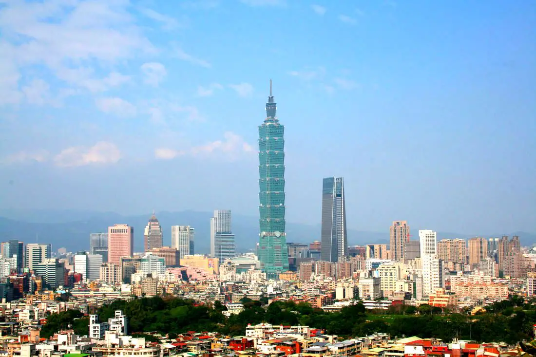
Taiwan is the best kept secret in Asia, and is a great destination to travel. But if you come to Taipei on a business trip or layover, what are the best things to see and do in the city with limited time?
Below we have laid out what we feel are the best one day itineraries in Taipei for those coming to Taiwan for the first time. Brief Historical Background of Taipei: The land on which Taipei now stands on what was once part of Basay tribal land. The Basay people had lived on the land for thousands of years before the first Chinese settlers ever came. Chinese settlers from Fujian began living here during the Dutch rule in the 1600s. The first Chinese settlers came to the area in the mid-1800's during the Qing Dynasty. They created a public area for drying rice and grain, called Dadaocheng (大稻埕) which also became the central market in the area. The earliest trading shops were built in 1851, mainly selling rice, sugar, camphor, and tea. Dihua Street (迪化街) was created around this time, making it the oldest street in Taipei. Most of the buildings were one story and made of red brick in Fujian style, and later western style houses were built. The walls and gates of Taipei were completed in 1884. In 1891, the first train connecting Keelung and Taipei was completed. During the Japanese era, in 1904 the walls of Taipei were destroyed after less than 30 years, and Taipei was re-planned into the capital of Taiwan. After the ROC took control of Taiwan, Taipei continued as the capital city, as well as the financial hub of Taiwan. During the Taiwan miracle, many rural families moved from southern Taiwan to factories and offices in Taipei, making Taipei the most populous urban area in Taiwan. Currently, Taipei is the most advanced and affluent city in Taiwan. It also has Taiwan's most advanced public transportation system, making it easy for millions of commuters to live outside the city where rents are cheaper. Now, most of Taiwan's economic activity is based in this city. Basic Taipei Travel Tips:
When should you go to Taipei? In my opinion, the best weather in Taipei is from March-May, and October - November, when the temperatures stay around 26 degrees Celsius and there is not as much rain. Summers are also nice, with the most sunny weather, but also hot and rainy. Winters can be cold (but not below freezing) and usually wet. Overall, there is no wrong answer as to what time of year you should visit Taipei. You will have a great time here at any time of year. Hotels in Taipei: High end: We have stayed at and recommend the Yuanshan Grand Hotel, once the tallest building in Taiwan and still the most grand (book on Booking.com here, Tripadvisor here, or Agoda here). We have also stayed at and recommend the Grand Hyatt (book on Booking.com here, Tripadvisor here, Agoda here, or Hotels.com here), Marriot (book on Booking.com here, Tripadvisor here, Agoda here, or Hotels.com here), Sheraton (book on Booking.com here, Tripadvisor here, Agoda here, or Hotels.com here), Shangri-la (book on Booking.com here, Tripadvisor here, Agoda here, or Hotels.com here), and Regent (book on Booking.com here, Tripadvisor here, Agoda here, or Hotels.com here), which are all very high quality hotels in the middle of Taipei City. We also recommend Fullon Hotel which has locations in Tamsui and Fulong near the beach (book on Booking.com here, Tripadvisor here, Agoda here, or Hotels.com here). Budget Hotels: We have stayed at and also recommend Fu Chang Hotel in Ximending, which is within walking distance of Ximending shopping district (book on Booking.com here, Tripadvisor here, or Agoda here). We have also stayed at and recommend Hai Xia Your Home which is right in front of Fulong Beach (book on Booking.com here, Tripadvisor here, Agoda here, or Hotels.com here). Looking for a hotel? We recommend booking through Booking.com here, which provides the best quality selection of accommodation in Taiwan. Find out where to stay in our Taiwan hotels guide or search for the best hotel deals in Taiwan here. Tours in Taipei: There are many tour itineraries that you can enjoy in Taipei that will take you to multiple destinations and arrange transportation. For more information, you can check out Tripadvisor here, KKday here or Klook here, which are both great tour websites that can connect you with the right tour and tour guide for you. Here are some of the most popular tours of Taipei on TripAdvisor:
Attractions in Taipei: There are many attractions that you can enjoy in Taipei such as Taipei 101 Observatory, Taipei 101 460 Skyline Observatory, Taipei Children's Amusement Park, Maokong Gondola, National Palace Museum, Yehliu Ocean World, Yehliu Geopark, National Museum of Marine Science and Biology, i-ride 5D cinema, Astronomical Museum, Miniatures Museum of Taiwan, Double Decker Sightseeing Bus, Miramar Ferris Wheel Ticket, Taipei Zoo, Heping Island Park, Ju Ming Museum, Yuanshan Hotel Secret Road, National Taiwan Museum, New Taipei Gold Museum, Futian Leisure Farm, Chiang Kai-shek Shilin Residence, Chi Po-lin Museaum, Beitou Museum, Tsao Wonderland, Railway Museum, Fort San Domingo, 13 Levels Archaeology Museum, Austin Land, Museum of World Religions, Formosan Aboriginies Museum, ASE Parent-child Park, teamLab Future Park, Yukids Island, VR Experience, Bat Cave, Neidong Waterfall, Candlestick Islet, Jurassic Snow Park, Zhonghe High5 Amusement Park, Longshan Temple, Xingtian Temple, Ningxia Night Market, Yansan Night Market, Meteor Garden, Yingge Old Street, and many more attractions on Tripadvisor here, Klook here, or KKday here. Activities in Taipei: Don't forget that there are many activities available in Taipei such as Indoor Skiing, Rock Climbing, Hiking, Wakeboarding, Surfing, Speedboat Surfing, SUP / Paddle Boarding, Diving, Snorkeling Kayaking, Canoeing, Water Biking, River Tracing / Canyoneering, ATVing, Horse Riding, Cooking Class, Archery, Ice Skating, Roller Skating, Tree Climbing, Urban Camping, Glamping, Motorcycling, Motorbike Tour, Dragon Boat Racing, Escape Room, Shen'ao Rail Bike, Laser Gun Experience, Batting Cages, Bowling, Paintball, Flight Simulation Experience, Taipei Tram Driving Experience, Rail Simulation Experience, Taipei 101 Observation Deck activity, Strawberry Picking, Professional Photo Shoot, Body Relaxation SPA, Night Tour, Calligraphy Workshop, and more on Tripadvisor here, Klook here, or KKday here. Just to let you know, if you book using the links above, we get some commission at no cost to you, and you can help support our blog. Some of the Klook links may not work if you are using an Ad blocker. You can click here to receive $5 USD on your first Klook purchase. How to get there: The only way to get to Taiwan is via airplane. Planes leave daily from Taipei's Songshan and Toayuan Airport. Taoyuan Airport: Taoyuan is Taiwan's largest airport and typically has cheaper flights and more flight times to choose from. It's about an hour's journey from Taoyuan Airport to the center of Taipei. You can travel via MRT, HSR, bus, or taxi to get to Taipei. You can get 30% off the Taoyuan Airport VIP lounge on KKday here. Songshan Airport: Songshan is a small airport in Taipei's city center, and can be a convenient option for people traveling within Asia. The airport is right on the Taipei MRT brown line. You can book cheap flights to Taiwan on KKday here, Trip.com here, CheapO Air here, or Kiwi here. How to get around in Taipei: Taipei's transportation system is convenient and safe. There are many options you can consider to get around in Taipei below: By Train: Gets you to the city center of all major cities in Taiwan. It is about 800NT to get from Taipei to Kaohsiung. Roughly half the price of the HSR. Book tickets via the normal train (TRA) on Klook here. By HSR: (High-Speed Rail) – Gets you quickly from north to south. Besides Taipei and Kaohsiung, most of the stations are far from city centers. It costs about 1500NT to get from Taipei to Kaohsiung. You can book tickets to the high-speed rail (HSR) on Klook here or KKDay here. By MRT: (Mass Rapid Transit, Metro train, subway) – Easily gets you around Taipei and Kaohsiung. You can purchase a discount easy card to use on the MRT from Klook here or KKday here. You can also book an MRT travel pass on Klook here. By Bus: Buses can be tricky. Long-range buses such as Ubus and King Bus are easier to understand and cheaper than the local train. They can take you to the city center of every city throughout Taiwan and to remote tourist destinations such as sun moon lake. A long-range bus from Taipei to Kaohsiung is about 500 NT. You can also book tickets to travel to Shifen via inter-city bus on Klook here. You can also book a Taipei Sightseeing: Hop On, Hop Off Open Top Bus on TripAdvisor here. By Taxi: You can take short rides for about 150 NT, or hire a Taxi for a day for around 150 USD. By Car: If you are looking for car rentals, you can also search Qeeq here, Klook here, or KKday here. You can also check out our car rental guide here. By Scooter: Looking for scooter rental in Taipei? You can search on Klook here or KKday here to search for options. You can also check out our scooter rental guide here. By Bicycle: Cycling is the best way to enjoy Taiwan's landscapes if you have the time and energy. Looking for bicycle rentals in Taiwan? You can use Taiwan's many Youbike sharing stations, or search for rentals on KKday here, and search for tours on Klook here. You can also check out our Taiwan cycling guide here. ​You can also book a Sunset Riverside Bike Ride and Historical Tour, 4 Hour Cycling in Taipei, Ultimate 8-Hour Cycling City Tour, or Taipei City Bike Tour with Night Market Experience on TripAdvisor here. For more information, check out our Taiwan transportation guide here. Tourist Site Map: Before we get started, below is a map of the places mentioned in this blog: 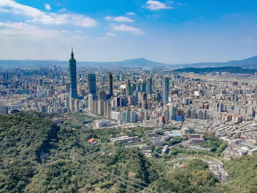
On your next trip to Taipei, you should not just limit your time to inside Taipei City limits. Expand your horizons and find some awesome day trips that will help you discover another part of Taiwan and appreciate this island in a new way.
Below we have presented some of the best day trips that we know of around Taipei. Basic Taipei Travel Tips:
When should you go to Taipei? In my opinion, the best weather in Taipei is from March-May, and October - November, when the temperatures stay around 26 degrees Celsius and there is not as much rain. Summers are also nice, with the most sunny weather, but also hot and rainy. Sponsored Links Winters can be cold (but not below freezing) and usually wet. Overall, there is no wrong answer as to what time of year you should visit Taipei. You will have a great time here at any time of year. Hotels in Taipei: High end: We have stayed at and recommend the Yuanshan Grand Hotel, once the tallest building in Taiwan and still the most grand (book on Booking.com here, Tripadvisor here, or Agoda here). We have also stayed at and recommend the Grand Hyatt (book on Booking.com here, Tripadvisor here, Agoda here, or Hotels.com here), Marriot (book on Booking.com here, Tripadvisor here, Agoda here, or Hotels.com here), Sheraton (book on Booking.com here, Tripadvisor here, Agoda here, or Hotels.com here), Shangri-la (book on Booking.com here, Tripadvisor here, Agoda here, or Hotels.com here), and Regent (book on Booking.com here, Tripadvisor here, Agoda here, or Hotels.com here), which are all very high quality hotels in the middle of Taipei City. We also recommend Fullon Hotel which has locations in Tamsui and Fulong near the beach (book on Booking.com here, Tripadvisor here, Agoda here, or Hotels.com here). Budget Hotels: We have stayed at and recommend and also Fu Chang Hotel in Ximending, which is within walking distance of Ximending shopping district (book on Booking.com here, Tripadvisor here, or Agoda here). We have also stayed at and recommend Hai Xia Your Home which is right in front of Fulong Beach (book on Booking.com here, Tripadvisor here, Agoda here, or Hotels.com here). Looking for a hotel? We recommend booking through Booking.com here, which provides the best quality selection of accommodation in Taiwan. Find out where to stay in our Taiwan hotels guide or search for the best hotel deals in Taiwan here. Tours in Taipei: There are many tour itineraries that you can enjoy in Taipei that will take you to multiple destinations and arrange transportation. For more information, you can check out Tripadvisor here, KKday here or Klook here, which are both great tour websites that can connect you with the right tour and tour guide for you. Sponsored Links Here are some of the post popular tours of Taipei on Tripadvisor:
Attractions in Taipei: There are many attractions that you can enjoy in Taipei such as Taipei 101 Observatory, Taipei 101 460 Skyline Observatory, Taipei Children's Amusement Park, Maokong Gondola, National Palace Museum, Yehliu Ocean World, Yehliu Geopark, National Museum of Marine Science and Biology, i-ride 5D cinema, Astronomical Museum, Miniatures Museum of Taiwan, Double Decker Sightseeing Bus, Miramar Ferris Wheel Ticket, Taipei Zoo, Heping Island Park, Ju Ming Museum, Yuanshan Hotel Secret Road, National Taiwan Museum, New Taipei Gold Museum, Futian Leisure Farm, Chiang Kai-shek Shilin Residence, Chi Po-lin Museaum, Beitou Museum, Tsao Wonderland, Railway Museum, Fort San Domingo, 13 Levels Archaeology Museum, Austin Land, Museum of World Religions, Formosan Aboriginies Museum, ASE Parent-child Park, teamLab Future Park, Yukids Island, VR Experience, Bat Cave, Neidong Waterfall, Candlestick Islet, Jurassic Snow Park, Zhonghe High5 Amusement Park, Longshan Temple, Xingtian Temple, Ningxia Night Market, Yansan Night Market, Meteor Garden, Yingge Old Street, and many more attractions on Tripadvisor here, Klook here, or KKday here. Activities in Taipei: Indoor Skiing, Rock Climbing, Hiking, Wakeboarding, Surfing, Speedboat Surfing, SUP / Paddle Boarding, Diving, Snorkeling Kayaking, Canoeing, Water Biking, River Tracing / Canyoneering, ATVing, Horse Riding, Cooking Class, Archery, Ice Skating, Roller Skating, Tree Climbing, Urban Camping, Glamping, Motorcycling, Motorbike Tour, Dragon Boat Racing, Escape Room, Shen'ao Rail Bike, Laser Gun Experience, Batting Cages, Bowling, Paintball, Flight Simulation Experience, Taipei Tram Driving Experience, Rail Simulation Experience, Taipei 101 Observation Deck activity, Strawberry Picking, Professional Photo Shoot, Body Relaxation SPA, Night Tour, Calligraphy Workshop rand more on Tripadvisor here, Klook here, or KKday here. Sponsored Links Just to let you know, if you book using the links above, we get some commission at no cost to you, and you can help support our blog. Some of the Klook links may not work if you are using an Ad blocker. You can click here to receive $5 USD on your first Klook purchase. How to get there: The only way to get to Taiwan is via airplane. Planes leave daily from Taipei's Songshan and Toayuan Airport. Taoyuan Airport: Taoyuan is Taiwan's largest airport and typically has cheaper flights and more flight times to choose from. It's about an hour's journey from Taoyuan Airport to the center of Taipei. You can travel via MRT, HSR, bus, or taxi to get to Taipei. You can get 30% off the Taoyuan Airport VIP lounge on KKday here. Songshan Airport: Songshan is a small airport in Taipei's city center, and can be a convenient option for people traveling within Asia. The airport is right on the Taipei MRT brown line. You can book cheap flights to Taiwan on KKday here, Trip.com here, CheapO Air here, or Kiwi here. How to get around in Taipei: Taipei's transportation system is convenient and safe. There are many options you can consider to get around in Taipei below: By Train: Gets you to the city center of all major cities in Taiwan. It is about 800NT to get from Taipei to Kaohsiung. Roughly half the price of the HSR. Book tickets via the normal train (TRA) on Klook here. By HSR: (High-Speed Rail) – Gets you quickly from north to south. Besides Taipei and Kaohsiung, most of the stations are far from city centers. It costs about 1500NT to get from Taipei to Kaohsiung. You can book tickets to the high-speed rail (HSR) on Klook here or KKDay here. By MRT: (Mass Rapid Transit, Metro train, subway) – Easily gets you around Taipei and Kaohsiung. You can also book an MRT travel pass on Klook here. Sponsored Links By Bus: Buses can be tricky. Long-range buses such as Ubus and King Bus are easier to understand and cheaper than the local train. They can take you to the city center of every city throughout Taiwan and to remote tourist destinations such as sun moon lake. A long-range bus from Taipei to Kaohsiung is about 500 NT. You can also book tickets to travel to Shifen via inter-city bus on Klook here. You can also book a Taipei Sightseeing: Hop On, Hop Off Open Top Bus on TripAdvisor here. By Taxi: You can take short rides for about 150 NT, or hire a Taxi for a day for around 150 USD. By Car: If you are looking for car rentals, you can also search Qeeq here, Klook here, or KKday here. You can also check out our car rental guide here. By Scooter: Looking for scooter rental in Taipei? Click here or here to search for options. You can also check out our scooter rental guide here. By Bicycle: Cycling is the best way to enjoy Taiwan's landscapes if you have the time and energy. Looking for bicycle rentals in Taiwan? You can use Taiwan's many Youbike bike sharing stations, or search for rentals on KKday here, and search for tours on Klook here. You can also check out our Taiwan cycling guide here. You can also book a Sunset Riverside Bike Ride and Historical Tour, 4 Hour Cycling in Taipei, Ultimate 8-Hour Cycling City Tour, or Taipei City Bike Tour with Night Market Experience on TripAdvisor here. For more information, check out our Taiwan transportation guide here. Tourist Site Map: Check out our map below of tourist sites in Taiwan, which is constantly updated: 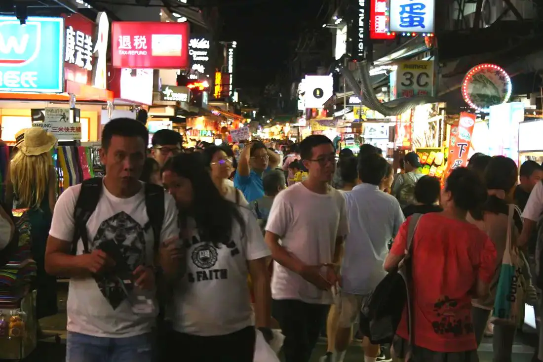
Taipei is full of vibrant night markets that will make your mouth water. With this guide, you can eat your way through Taipei's best night markets. Sometimes one night market is not enough, so why not visit them all?
Below we have presented some of the best Night Markets that we know of around Taipei. Basic Taipei Travel Tips:
When should you go to Taipei? In my opinion, the best weather in Taipei is from March-May, and October - November, when the temperatures stay around 26 degrees Celsius and there is not as much rain. Summers are also nice, with the most sunny weather, but also hot and rainy. Sponsored Links Winters can be cold (but not below freezing) and usually wet. Overall, there is no wrong answer as to what time of year you should visit Taipei. You will have a great time here at any time of year. Hotels in Taipei: High end: We have stayed at and recommend the Yuanshan Grand Hotel, once the tallest building in Taiwan and still the most grand (book on Booking.com here, Tripadvisor here, or Agoda here). We have also stayed at and recommend the Grand Hyatt (book on Booking.com here, Tripadvisor here, Agoda here, or Hotels.com here), Marriot (book on Booking.com here, Tripadvisor here, Agoda here, or Hotels.com here), Sheraton (book on Booking.com here, Tripadvisor here, Agoda here, or Hotels.com here), Shangri-la (book on Booking.com here, Tripadvisor here, Agoda here, or Hotels.com here), and Regent (book on Booking.com here, Tripadvisor here, Agoda here, or Hotels.com here), which are all very high quality hotels in the middle of Taipei City. We also recommend Fullon Hotel which has locations in Tamsui and Fulong near the beach (book on Booking.com here, Tripadvisor here, Agoda here, or Hotels.com here). Budget Hotels: We have stayed at and recommend and also Fu Chang Hotel in Ximending, which is within walking distance of Ximending shopping district (book on Booking.com here, Tripadvisor here, or Agoda here). We have also stayed at and recommend Hai Xia Your Home which is right in front of Fulong Beach (book on Booking.com here, Tripadvisor here, Agoda here, or Hotels.com here). Looking for a hotel? We recommend booking through Booking.com here, which provides the best quality selection of accommodation in Taiwan. Find out where to stay in our Taiwan hotels guide or search for the best hotel deals in Taiwan here. Tours in Taipei: There are many tour itineraries that you can enjoy in Taipei that will take you to multiple destinations and arrange transportation. For more information, you can check out Tripadvisor here, KKday here or Klook here, which are both great tour websites that can connect you with the right tour and tour guide for you. Sponsored Links Here are some of the post popular tours of Taipei on Tripadvisor:
Attractions in Taipei: There are many attractions that you can enjoy in Taipei such as Taipei 101 Observatory, Taipei 101 460 Skyline Observatory, Taipei Children's Amusement Park, Maokong Gondola, National Palace Museum, Yehliu Ocean World, Yehliu Geopark, National Museum of Marine Science and Biology, i-ride 5D cinema, Astronomical Museum, Miniatures Museum of Taiwan, Double Decker Sightseeing Bus, Miramar Ferris Wheel Ticket, Taipei Zoo, Heping Island Park, Ju Ming Museum, Yuanshan Hotel Secret Road, National Taiwan Museum, New Taipei Gold Museum, Futian Leisure Farm, Chiang Kai-shek Shilin Residence, Chi Po-lin Museaum, Beitou Museum, Tsao Wonderland, Railway Museum, Fort San Domingo, 13 Levels Archaeology Museum, Austin Land, Museum of World Religions, Formosan Aboriginies Museum, ASE Parent-child Park, teamLab Future Park, Yukids Island, VR Experience, Bat Cave, Neidong Waterfall, Candlestick Islet, Jurassic Snow Park, Zhonghe High5 Amusement Park, Longshan Temple, Xingtian Temple, Ningxia Night Market, Yansan Night Market, Meteor Garden, Yingge Old Street, and many more attractions on Tripadvisor here, Klook here, or KKday here. Activities in Taipei: Indoor Skiing, Rock Climbing, Hiking, Wakeboarding, Surfing, Speedboat Surfing, SUP / Paddle Boarding, Diving, Snorkeling Kayaking, Canoeing, Water Biking, River Tracing / Canyoneering, ATVing, Horse Riding, Cooking Class, Archery, Ice Skating, Roller Skating, Tree Climbing, Urban Camping, Glamping, Motorcycling, Motorbike Tour, Dragon Boat Racing, Escape Room, Shen'ao Rail Bike, Laser Gun Experience, Batting Cages, Bowling, Paintball, Flight Simulation Experience, Taipei Tram Driving Experience, Rail Simulation Experience, Taipei 101 Observation Deck activity, Strawberry Picking, Professional Photo Shoot, Body Relaxation SPA, Night Tour, Calligraphy Workshop rand more on Tripadvisor here, Klook here, or KKday here. Just to let you know, if you book using the links above, we get some commission at no cost to you, and you can help support our blog. Some of the Klook links may not work if you are using an Ad blocker. You can click here to receive $5 USD on your first Klook purchase. How to get there: The only way to get to Taiwan is via airplane. Planes leave daily from Taipei's Songshan and Toayuan Airport. Taoyuan Airport: Taoyuan is Taiwan's largest airport and typically has cheaper flights and more flight times to choose from. It's about an hour's journey from Taoyuan Airport to the center of Taipei. You can travel via MRT, HSR, bus, or taxi to get to Taipei. You can get 30% off the Taoyuan Airport VIP lounge on KKday here. Songshan Airport: Songshan is a small airport in Taipei's city center, and can be a convenient option for people traveling within Asia. The airport is right on the Taipei MRT brown line. You can book cheap flights to Taiwan on KKday here, Trip.com here, CheapO Air here, or Kiwi here. How to get around in Taipei: Taipei's transportation system is convenient and safe. There are many options you can consider to get around in Taipei below: By Train: Gets you to the city center of all major cities in Taiwan. It is about 800NT to get from Taipei to Kaohsiung. Roughly half the price of the HSR. Book tickets via the normal train (TRA) on Klook here. By HSR: (High-Speed Rail) – Gets you quickly from north to south. Besides Taipei and Kaohsiung, most of the stations are far from city centers. It costs about 1500NT to get from Taipei to Kaohsiung. You can book tickets to the high-speed rail (HSR) on Klook here or KKDay here. By MRT: (Mass Rapid Transit, Metro train, subway) – Easily gets you around Taipei and Kaohsiung. You can also book an MRT travel pass on Klook here. By Bus: Buses can be tricky. Long-range buses such as Ubus and King Bus are easier to understand and cheaper than the local train. They can take you to the city center of every city throughout Taiwan and to remote tourist destinations such as sun moon lake. A long-range bus from Taipei to Kaohsiung is about 500 NT. You can also book tickets to travel to Shifen via inter-city bus on Klook here. You can also book a Taipei Sightseeing: Hop On, Hop Off Open Top Bus on TripAdvisor here. By Taxi: You can take short rides for about 150 NT, or hire a Taxi for a day for around 150 USD. By Car: If you are looking for car rentals, you can also search Qeeq here, Klook here, or KKday here. You can also check out our car rental guide here. By Scooter: Looking for scooter rental in Taipei? Click here or here to search for options. You can also check out our scooter rental guide here. By Bicycle: Cycling is the best way to enjoy Taiwan's landscapes if you have the time and energy. Looking for bicycle rentals in Taiwan? You can use Taiwan's many Youbike bike sharing stations, or search for rentals on KKday here, and search for tours on Klook here. You can also check out our Taiwan cycling guide here. You can also book a Sunset Riverside Bike Ride and Historical Tour, 4 Hour Cycling in Taipei, Ultimate 8-Hour Cycling City Tour, or Taipei City Bike Tour with Night Market Experience on TripAdvisor here. For more information, check out our Taiwan transportation guide here. Tourist Site Map: Check out our map below of tourist sites in Taiwan, which is constantly updated: |
Author 作家I am an American expat who has extensive experience living, working, and traveling in Taiwan. In my day, I had to learn many things about Taiwan the hard way. But I have come to learn that Taiwan is one of the best places in the world for Foreigners to live. This blog does not represent the opinions of every foreigner in Taiwan. I am just trying to help others learn more about this beautiful country. Categories
|
 RSS Feed
