

If you only have a few days in Taiwan and you want to go somewhere outside of Taipei, you should definitely go to Taroko National Park. On an island full of mountains, rain forests, beaches, and abounding natural beauty, Taroko might just take the top spot as the most beautiful scenic area in Taiwan.
Taroko National Park is well known for its amazing marble cliffs and canyons carved out by the Liwu River. It is also a popular spot for hiking, rafting, and river tracing. If you have the time, come to the East coast and see it. If you don't have time, then make some time! History and Background: Taroko National Park is well known for its marble cliffs and canyons, and is also known as "The Marble Gorge." Millions of years ago, the rock we see today was sediment at the bottom of the Pacific Ocean, but oceanic and tectonic pressure turned it into limestone, and later into marble. Later the Eurasian plate was uplifted where Taiwan is today, and a gorge was cut out of the limestone thanks to the Liwu River. Taroko means "human being," from the Truku tribal language. Originally the Tupido Tribe settled in the area of what is now Tianxiang Taiti mesa. They built the Tupido Tribe Trail which was only 30 cm wide, and resided there until they were massacred by the Japanese in 1914. In 1917, the Japanese expanded the original trail made by the Tupido Tribe to 1.5 M and forced aboriginal tribesmen to carry goods along the trail to the east coast. This is now the Zhuilu Old Trail. Currently only 3km of the trail is open to the public. The Japanese created a national park in the Area in 1937, which was disestablished by the ROC in 1945, and then reenstated in as a national park in 1986. When to visit? Hualien is great year round, but it can get a little hot in the summer, and Typhoon season and heavy rain season lasts from about May to October. If you are afraid of the heat and rain then you can visit during winter when the temperatures are mild and the climate is usually dryer. Sponsored Links Where to stay? Most of the accommodation you will find is near the city center. If you only want to visit Hualien City and Taroko Gorge, you can consider booking a hotel near downtown, walking or cycling around the city, and taking a bus to Taroko Gorge. We have stayed at and recommend Dream Taiwan Homestay (Agoda / Booking.com / Expedia / Hotels.com), a high quality hostel for the money in downtown Hualien, Farglory Hotel (Agoda / Booking.com / Expedia / Hotels.com), right next to Farglory Ocean Park with amazing views of Hualien, and Goldenflower B&B (Agoda / Booking.com) in Yuli right next to Sixty Stone Mountain. You can find out where to stay in our Taiwan hotels guide or search for the best hotel deals in Taiwan here. How to get there: By Car: From Taipei, Take National Highway 5 to Yilan and then drive on the Suhua Highway 9 to Hualien. A few miles before Hualien City, the gorge will be on your right. By Train: Take the train to Hualien station, and from there you can rent a scooter or car, or take a tour bus to the gorge. For more travel information see here. You can book tickets to travel to Hualien via inter-city bus on Klook here. Book tickets via the normal train (TRA) on Klook here. Need travel insurance? Compare prices on Insubuy here. How to get around in Taroko Gorge: As always, we recommend renting a scooter as the best way to see Taiwan. However, you can also a great deal of Tainan by taking the train, inter-city bus, local bus, biking, or just walking. Getting around in a car is also a convenient option as there is plenty of parking pretty much everywhere in this less crowded county. By Bus: You can book a shuttle bus to Taroko Gorge from Hualien on Klook here. Scooter Rental: Looking for scooter rental in Hualien? You can search KKday here or Klook here to look for options. You can also check out our scooter rental guide here. Car Rental: If you are looking for car rentals in Hualien, you can also search Klook here or KKDay here. You can also check out our car rental guide here. Tours: You can find more tours and activities in Hualien such as Surfing, Paragliding, SUP / Paddle Boarding, Kayaking, Canoeing, River Tracing, River Rafting, Whale Watching, Snorkeling, Diving, ATV / 4-wheeling, Paintballing, Farm Dream Estates Zoo, Water Biking, Oyster Harvesting, Shrimp Harvesting, Indigenous Experience, Glamping, Cycling, Ziplining and much more on Klook here or KKday here. You can also book Wifi and SIM cards for Taiwan on Gigago here. Just to let you know, if you book using the links above, we get some commission at no cost to you, and you can help support our blog. You can click here to receive $5 USD on your first Klook purchase. Hours: 8:30AM-5PM (Zhuilu old trail is open from 7AM to 10PM). Flying a Drone? Apply for a drone permit here. Price: Free! (Except Zhuilu old trail, which is 200 NT per adult. See below for more info.) Map: Please see below:
0 Comments
If you only have a few days in Taiwan and you want to go somewhere outside of Taipei, you should definitely go to Taroko Gorge. On an island full of mountains, rain forests, beaches, and abounding natural beauty, Taroko Gorge might just take the top spot as the most beautiful scenic area in Taiwan.
Taroko National Park is well known for its amazing marble cliffs and canyons carved out by the Liwu River. It is also a popular spot for hiking, rafting, and river tracing. If you have the time, come to the East coast and see it. If you don't have time, then make some time! History and Background: Taroko National Park is well known for its marble cliffs and canyons, and is also known as "The Marble Gorge." Millions of years ago, the rock we see today was sediment at the bottom of the Pacific Ocean, but oceanic and tectonic pressure turned it into limestone, and later into marble. Later the Eurasian plate was uplifted where Taiwan is today, and a gorge was cut out of the limestone thanks to the Liwu River. Taroko means "human being," from the Truku tribal language. Originally the Tupido Tribe settled in the area of what is now Tianxiang Taiti mesa. They built the Tupido Tribe Trail which was only 30 cm wide, and resided there until they were massacred by the Japanese in 1914. In 1917, the Japanese expanded the original trail made by the Tupido Tribe to 1.5 M and forced aboriginal tribesmen to carry goods along the trail to the east coast. This is now the Zhuilu Old Trail. Currently only 3km of the trail is open to the public. The Japanese created a national park in the Area in 1937, which was disestablished by the ROC in 1945, and then reenstated in as a national park in 1986. When to visit? Hualien is great year round, but it can get a little hot in the summer, and Typhoon season and heavy rain season lasts from about May to October. If you are afraid of the heat and rain then you can visit during winter when the temperatures are mild and the climate is usually dryer. Currently the park is closed due to damage from the April 3rd, 2024 earthquake. Where to stay? Most of the accommodation you will find is near the city center. If you only want to visit Hualien City and Taroko Gorge, you can consider booking a hotel near downtown, walking or cycling around the city, and taking a bus to Taroko Gorge. We have stayed at and recommend Dream Taiwan Homestay (Agoda / Booking.com / Expedia / Hotels.com), a high quality hostel for the money in downtown Hualien, Farglory Hotel (Agoda / Booking.com / Expedia / Hotels.com), right next to Farglory Ocean Park with amazing views of Hualien, and Goldenflower B&B (Agoda / Booking.com) in Yuli right next to Sixty Stone Mountain. You can find out where to stay in our Taiwan hotels guide or search for the best hotel deals in Taiwan here. How to get there: By Car: From Taipei, Take National Highway 5 to Yilan and then drive on the Suhua Highway 9 to Hualien. A few miles before Hualien City, the gorge will be on your right. By Train: Take the train to Hualien station, and from there you can rent a scooter or car, or take a tour bus to the gorge. For more travel information see here. You can book tickets to travel to Hualien via inter-city bus on Klook here. Book tickets via the normal train (TRA) on Klook here. Need travel insurance? Compare prices on Insubuy here. How to get around in Taroko Gorge: As always, we recommend renting a scooter as the best way to see Taiwan. However, you can also a great deal of Tainan by taking the train, inter-city bus, local bus, biking, or just walking. Getting around in a car is also a convenient option as there is plenty of parking pretty much everywhere in this less crowded county. By Bus: You can book a shuttle bus to Taroko Gorge from Hualien on Klook here. Scooter Rental: Looking for scooter rental in Hualien? You can search KKday here or Klook here to look for options. You can also check out our scooter rental guide here. Car Rental: If you are looking for car rentals in Hualien, you can also search Klook here or KKDay here. You can also check out our car rental guide here. Tours: You can find more tours and activities in Hualien such as Surfing, Paragliding, SUP / Paddle Boarding, Kayaking, Canoeing, River Tracing, River Rafting, Whale Watching, Snorkeling, Diving, ATV / 4-wheeling, Paintballing, Farm Dream Estates Zoo, Water Biking, Oyster Harvesting, Shrimp Harvesting, Indigenous Experience, Glamping, Cycling, Ziplining and much more on Klook here or KKday here. You can also book Wifi and SIM cards for Taiwan on Gigago here. Just to let you know, if you book using the links above, we get some commission at no cost to you, and you can help support our blog. You can click here to receive $5 USD on your first Klook purchase. Hours: 8:30AM-5PM (Zhuilu old trail is open from 7AM to 10PM). Currently the park and Zhuilu trail are closed due to damage from the April 3rd, 2024 earthquake. Flying a Drone? Apply for a drone permit here. Price: Free! (Except Zhuilu old trail, which is 200 NT per adult. See below for more info.) Map: Please see below: 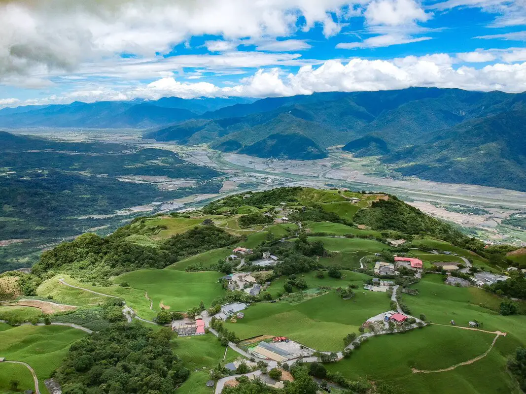
Taiwan's East Rift Valley has some of the most breathtaking scenery in Taiwan. It has towering mountains and vast tracks of flat rice fields. There are also amazing rivers, canyons, and waterfalls to explore. It is also home to Taiwan's International Balloon Festival. There is something for everyone in this area of Taiwan.
When to visit? The East Rift Valley is great year round, but it can get a little hot in the summer, and Typhoon season and heavy rain season last from about May to October. If you are afraid of the heat and rain then you can visit during winter when the temperatures are mild and the climate is usually dryer. Where to stay? Most of the accommodation you will find is near the city centers. If you only want to visit Hualien City or Taitung City, you can consider booking a hotel near downtown, walking or cycling around the city, and taking a bus to sites further away. We have stayed at and recommend Dream Taiwan Homestay (Agoda / Booking.com / Expedia / Hotels.com), a high quality hostel for the money in downtown Hualien, Farglory Hotel (Agoda / Booking.com / Expedia / Hotels.com), right next to Farglory Ocean Park with amazing views of Hualien, and Goldenflower B&B (Agoda / Booking.com) in Yuli right next to Sixty Stone Mountain. In Taitung have stayed at and recommend the Papago International Resort in Chishang, which is a five star hotel with private villas with pools for each room, and Mountain and Ocean B & B in Taimali, which is a quiet and affordable B&B right next to the beach. You can find out where to stay in our Taiwan hotels guide or search for the best hotel deals in Taiwan here. How to get to the East Rift Valley? You can book tickets to travel to the East Rift Valley via inter-city bus on Klook here. Book tickets via the normal train (TRA) on Klook here. Need travel insurance? Compare prices on Insubuy here. How to get around the East Rift Valley: As always, we recommend renting a scooter as the best way to see Taiwan. However, you can also a great deal of Tainan by taking the train, inter-city bus, local bus, biking, or just walking. Getting around in a car is also a convenient option as there is plenty of parking pretty much everywhere in this less crowded county. Scooter Rental: Looking for a scooter rental in Hualien or Taitung? You can search KKday here or Klook here to look for options. You can also check out our scooter rental guide here. Car Rental: If you are looking for car rentals in Hualien or Taitung, you can also search Klook here or KKDay here. You can also check out our car rental guide here. Tours: You can find more tours and activities in Hualien such as Surfing, Paragliding, SUP / Paddle Boarding, Kayaking, Canoeing, River Tracing, River Rafting, Whale Watching, Snorkeling, Diving, ATV / 4-wheeling, Paintballing, Farm Dream Estates Zoo, Water Biking, Oyster Harvesting, Shrimp Harvesting, Indigenous Experience, Glamping, Cycling, Ziplining and much more on Klook here or KKday here. You can also book Wifi and SIM cards for Taiwan on Gigago here. Just to let you know, if you book using the links above, we get some commission at no cost to you, and you can help support our blog. You can click here to receive $5 USD on your first Klook purchase. 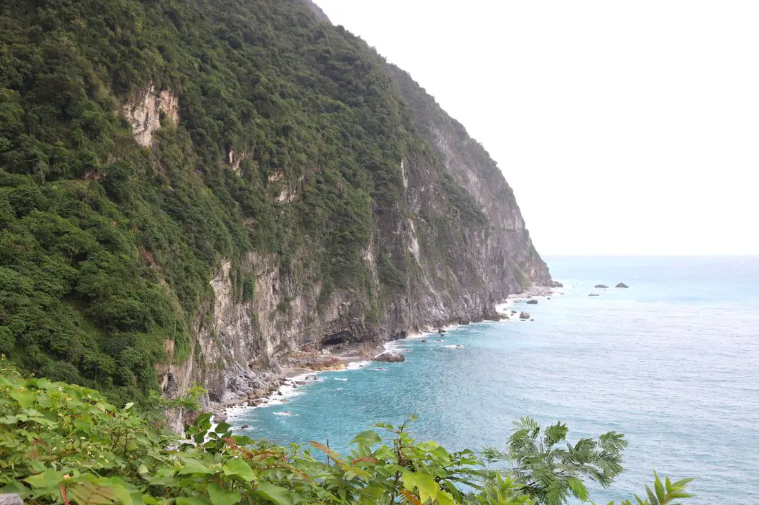
Taiwan's East Coast has the most beautiful scenery in Taiwan. From the deepest marble gorge in the world to outer islands, mountains, rivers, and huge sea cliffs, there are unmissable natural wonders for you to explore. In addition, there are endless outdoor activities and water sports that you can take part in here.
When to go: The best time to go they say is around May when it is not too hot and there are no northeasterly winds or typhoons. The typhoon season lasts from around June to October. The busy season is during summer break from June to August, during which time it can be hard to book a hostel or airplane ticket. Winter is the less crowded season, but the water will be colder, there will be constant wind (which could cancel transportation), and it will rain more often. How to get there: By Plane: Traveling to Taitung or Hualien by plane is the fastest way to get there. The trip only takes one hour from Taipei, and there are planes that leave daily through Mandarin Airlines and Uni Air. From Taitung, where you can switch to Saily Air which will take you the rest of the way to Green Island or Orchid Island. A plane ticket to Taitung takes about one hour and costs about 5000 NT per round trip. You can book discount tickets to Taitung on KKday here. By Train: The train ride from Taipei to Taitung takes 3-4 hours and costs about 800 NT one way. Book tickets via the normal train (TRA) on Klook here. By Bus: Busses leave hourly from Taipei to the East Coast. A bus from Taipei to Hualien now only takes about 2.5 hours. You can book tickets to travel to Taiwan's East Coast via inter-city bus on Klook here. By Bicycle: Cycling is the best way to enjoy Taiwan's landscapes if you have the time and energy. Looking for bicycle rentals in Taiwan? You can search on KKday here and search for tours on Klook here. You can also check out our Taiwan cycling guide here. By Car/Scooter: From Taipei, a car ride to Taitung takes about six hours, and a scooter ride takes about eight hours. You can rent a scooter on Klook or KKday. Scooter rental is about 300 NT per day. You can check out our scooter rental guide here. You can also rent a car for about 1500 NT per day. You can rent a car on Qeeq here or Klook here. You can hire a driver or taxi, and you can charter a car here. You can check out our car rental guide here. Tours: There are many tours and activities available on Taiwan's East Coast such as snorkeling, diving, SUPing, Surfing, Speed Boating, Glamping, River tracing, Paragliding, Kayaking, Canoeing, River Tracing, River Rafting, River Tubing, Pack Rafting, Whale Watching, ATV / 4-wheeling, Paintballing, Water Biking, Glamping, Cycling, Ziplining, Horse Riding, and many others, which you canbook through Klook here or KKday here. Accommodation: Looking for a hotel? We recommend booking through Agoda here, which provides the best quality selection of accommodation on the islands. Yilan: We have stayed at and recommend Ying Shih Guest House, a resort in Datong Township near Taipingshan and Fan Fan Hot Spring, and Jiaosi Hotspring Hotel, a hotel with hot springs in each room. We have also stayed at Toucheng Leisure Farm, a recreational farm and experience center in Toucheng (you can book on Agoda here). Hualien: We also have stayed at and recommend Dream Taiwan Homestay (Agoda / Booking.com), a high quality hostel for the money in downtown Hualien, Farglory Hotel (Agoda / Booking.com), right next to Farglory Ocean Park with amazing views of Hualien, and Goldenflower B&B (Agoda / Booking.com) in Yuli right next to Sixty Stone Mountain. You can find out where to stay in our Taiwan hotels guide or search for the best hotel deals in Taiwan here. Taitung: We have stayed at and recommend the Papago International Resort in Chishang, which is a five star hotel with private villas with pools for each room, and Mountain and Ocean B & B in Taimali, which is a quiet and affordable B&B right next to the beach. Looking for scooter rental in Taiwan? Click here or here to search for options. If you are looking for car rentals, you can also search here. You can also book Wifi and SIM cards for Taiwan on Gigago here. Just to let you know, if you book using the links above, we get some commission at no cost to you, and you can help support our blog. You can click here to receive $5 USD on your first Klook purchase. 
This month marks the 10th anniversary of this blog, so to celebrate I am making a blog tracing back our first round-island trip lasting 14 days and 13 nights made in 2014. During this journey we rented a car in Taipei, and circled Taiwan clockwise, visiting Taroko Gorge, Kenting, Xiaoliuqiu, Alishan, Sun Moon Lake, and many more places along the way. I am the kind of guy who likes to bask in nostalgia, but also I hope that laying out this experience in the open as well as the lessons we learned about travel in Taiwan along the way (and what I know now in 2024) will be helpful to other foreigners coming to Taiwan.
Some background on why this trip happened: This was not our first trip to Taiwan. Scott and I had been Latter-day Saint missionaries in Taiwan from 2011 to 2012 in the Taichung Mission, which covers Taichung to Pingtung but nothing north or east of that. We still had a lot of friends in Taiwan that we missed, we missed Taiwanese food, and there were the entire north and east parts of the island for us to explore. We decided it would be a once-in-a-lifetime opportunity to tour Taiwan now because later on in our lives we would likely have work and family obligations that would not allow us to take a 14-day trip around Taiwan. Being poor college students at the time, we had a very limited budget (for reference, I was making 700 USD a month as a janitor and I could only save about half of that after rent and food). Originally another friend planned to come with us, but he backed out because he got married. Scott's brother Matt decided to come along too. Just so you know, Scott and I know Chinese, but Matt doesn't. It makes traveling easier to know the language but you can still get by in Taiwan without it. The Plane Ride: We took the cheapest flight available on Shenzhen Airlines, which had many flights for cheap to the US at the time. For 700 USD we bought a round trip from LA to Beijing to Taipei and back. Renting a car in Taiwan: Before we began our trip, we planned on rounding the island by Scooter. This can be a fun way to explore Taiwan. As a side note, you can book a Motorcycling experience on Klook here, or a half-day Motorbike Tour on KKday here. If you are looking for a multi-day, in-depth tour of Taiwan via motorbike, we recommend contacting [email protected] who schedules regular 10-day motorbike tours of Taiwan. The tour guide is a long-term expat in Taiwan who has been giving riding tours of Taiwan for 16 years now. You can also check out our scooter rental guide here. After crunching the numbers, we figured that we could rent a car for just as cheap as three scooters, and we wouldn't have to worry about rain or luggage. A scooter would be 300 NT per day, and for three people 900 NT per day, but we found a car rental place that would rent us a small Nissan March for 700 NT a day (that car company was called Good Cars 固得汽車 in Zhonghe, you can find their information in our Taiwan Car Rental Guide here). After arriving at Taoyuan International Airport, we took a bus to Taipei and made our way to Zhonghe at a friend's house and picked up the rental car. At the end of the trip, we found the price was a few thousand NT more than we expected because of highway tolls (about 1.5 NT per kilometer). SIM Card: I bought a pre-paid SIM card from Taiwan Mobile for 500 TWD that lasted the whole trip. I think it was only a few GB of data, but I had a crappy phone and was not using much data. Map: Check out a map of places we visited on this trip below: 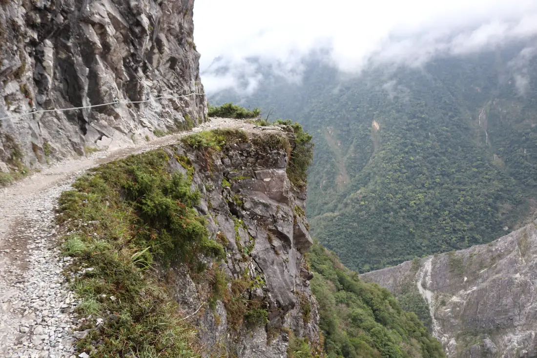
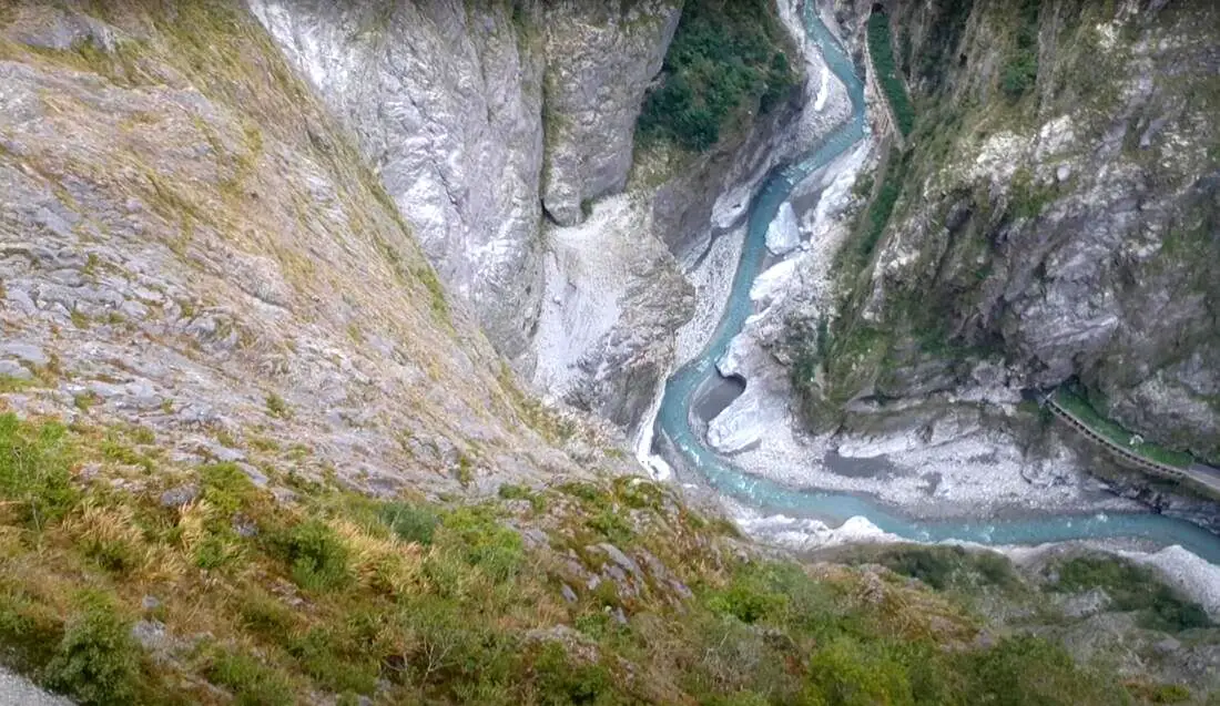
Zhuilu Old Trail (aka Jhueilu/Zhuilu Old Road) is known as "the best day hike in Taiwan" and has a trail on "the No. 1 cliff in east Asia." It is for sure one of the most beautiful and exciting hiking trails in Taiwan. It features a vertical cliff section with amazing views 500 meters above the world's deepest marble gorge (Taroko Gorge).
History: The Zhuilu Old Trail was created hundreds of years ago by the Truku indigenous people to connect their villages in Taroko Gorge and the central mountain range. Originally the cliff sections of the trail were just 30 cm wide! These indigenous people remained basically autonomous and undisturbed until the Japanese occupation of Taiwan. However after conflicts such as the Xincheng incident in 1896 and the Weili Incident in 1906, where combined more than 50 Japanese people were killed by indigenous warriors, the Japanese decided to tighten control of the mountain aborigines and natural resources in the area, and started the Truku War. The war lasted from May-August 1914, and in the process the Japanese forced indigenous men to widen the Zhuilu Trail to 1.5 meters so that they could transport artillery through the mountainous terrain. 37 people died during this widening process during and after the war, which included using dynamite to blast open the rock while only using ropes. The Truku lost the war, which included 3,000-5,000 indigenous warriors with modern weapons pitted against a Japanese fighting force of over 10,000. The Japanese lost over 300 men in the fight. After the war, the Japanese tried to dismantle their culture by scattering the people, preventing them from hunting, and forcing the children to attend Japanese schools. The Japanese then built the Old Cross-Hehuan Mountain Road which stretched 145 KM from Taroko Gorge to Wushe in Nantou from 1914 to 1933, with the Zhuilu Old Trail as part of it. They set up police stations/outposts along the trail as well, including Badagang Village which had a school, hospital, and inns for travelers. After the ROC took control of Taiwan, the trail was disused except for some expert hikers, and the Japanese police outposts were abandoned. After the 921 earthquake in 1999, the trail was closed for nine years until 2008. At around 2016 (probably after a typhoon), the 7KM after the Zhuilu Cliffs were closed off, so now the only walk-able part of the trail is 3.1 KM long from Swallow Grotto to the Zhuilu Cliff Outpost. It doesn't seem like this part of the trail will reopen soon. The cliff section of the trail is 750 meters above sea level, and nearly 500 meters above the valley floor. The distance between these cliffs and the cliffs on the opposite side of the gorge is only about 200 meters. The mountain that the cliffs are part of rises 1600 meters above sea level, and over 1000 meters above the valley floor, and is made completely of marble. Hours: Currently the trail is closed due to damage from the April 3rd, 2024 earthquake. Must enter between 7 AM and 10 AM the day of the permit (unless the gorge is closed due to typhoon/natural disaster) Permits Required: Only a park access permit is required. You can apply for a permit in English here. Only 96 people are allowed on weekdays and 156 people on weekends and holidays. Police permits are no longer required for this trail. Drones: Please note that if you want to fly a drone in Taroko National Park, you need to apply for a permit at least seven days in advance. You can apply to fly a drone (Chinese only) here. Price: 200 NT per person Duration: 6.2 Km round trip 500 meter elevation gain About 6 hours The trail is 3.1 KM one way to the Zhuilu Cliff Outpost, and gains 500 meters in elevation. It took me (one person with only one 30 minute break to fly a drone) three hours there and back (I was told this is a very fast pace). Some people say that it takes an average of six hours there and back. If you are taking people that are not in shape, expect to take most of the day hiking. When to go: On a sunny dry day. The rocks can get slippery and a fall on some of the trails could kill you. But if you are careful and bring proper hiking boots and gear, hiking on a wet day should be fine. Avoid typhoons and heavy rains at all costs. There gorge will close during typhoons anyway. Typhoon season lasts from May to October. Other than that, this hike is great year round. Need travel insurance? Compare prices on Insubuy here. Where to stay? Most of the accommodation you will find is near the city center. If you only want to visit Hualien City and Taroko Gorge, you can consider booking a hotel near downtown, walking or cycling around the city, and taking a bus to Taroko Gorge. We have stayed at and recommend Dream Taiwan Homestay (Agoda / Booking.com / Expedia / Hotels.com), a high quality hostel for the money in downtown Hualien, Farglory Hotel (Agoda / Booking.com / Expedia / Hotels.com), right next to Farglory Ocean Park with amazing views of Hualien, and Goldenflower B&B (Agoda / Booking.com) in Yuli right next to Sixty Stone Mountain. You can find out where to stay in our Taiwan hotels guide or search for the best hotel deals in Taiwan here. You can also book Wifi and SIM cards for Taiwan on Gigago here. How to get there: By Train/Bus: Take the TRA to Hualien Station, and then switch to the Hualien Bus 1133A. Get off at Swallow Grotto (Yanzikou 燕子口). Also you can take the TRA to Xincheng Station and take Taroko Bus 302. You can book tickets to travel to Hualien via inter-city bus on Klook here. Book tickets via the normal train (TRA) on Klook here. By Car/Scooter: Go west on the Central Cross Island Highway until you reach swallow grotto after Xipan Tunnel. There is only parking near Jinheng Park (靳珩公園) 500 meters down the road from the trail entrance. Looking for a scooter rental in Hualien? You can search KKday here or Klook here to look for options. You can also check out our scooter rental guide here. If you are looking for car rentals in Hualien, you can also search Klook here or KKDay here. You can also check out our car rental guide here. Tours: You can book a tour of Zhuilu Old Trail on Klook here or KKday here. Map: For the location of the start of the trail, please see below: 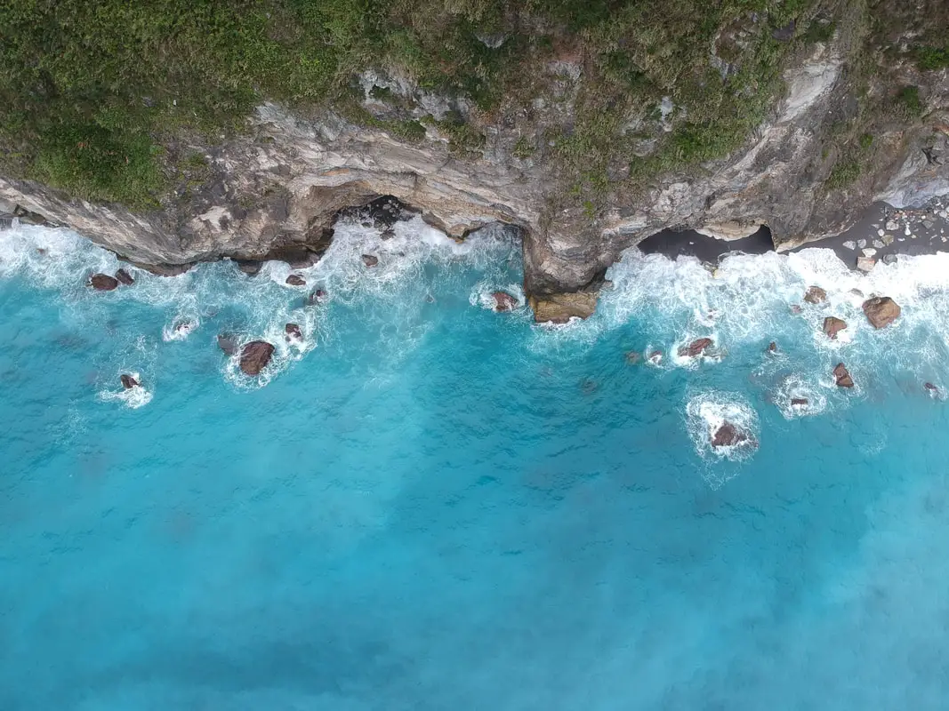
The Qingshui Cliffs in Taroko National Park on the coast of Hualien are some of the most spectacular geological features in the country, and the world. The tallest peak on the cliffs is 2,408 meters (7,900 feet) above sea level, and drops straight into the Pacific Ocean. It is a spectacular sight to behold.
Background: Taroko National Park is well known for its marble cliffs and canyons, and is also known as "The Marble Gorge." Millions of years ago, the rock we see today was sediment at the bottom of the Pacific Ocean, but oceanic and tectonic pressure turned it into limestone, and later into marble. Later the Eurasian plate was uplifted where Taiwan is today, and the cliffs were lifted out of the ocean. The cliffs are subject to constant erosion and rockslides are common. The cliffs are roughly 12 KM long and rise to over 2400 meters. They are a popular scenic stop along the Suhua highway that connects Yiland and Hualien. Hours: 24/7 Price: Free: When to visit? Hualien is great year round, but it can get a little hot in the summer, and Typhoon season and heavy rain season last from about May to October. If you are afraid of the heat and rain then you can visit during winter when the temperatures are mild and the climate is usually dryer. Where to stay? Most of the accommodation you will find is near the city center. If you only want to visit Hualien City and Taroko Gorge, you can consider booking a hotel near downtown, walking or cycling around the city, and taking a bus to Taroko Gorge. We have stayed at and recommend Dream Taiwan Homestay (Agoda / Booking.com / Expedia / Hotels.com), a high quality hostel for the money in downtown Hualien, Farglory Hotel (Agoda / Booking.com / Expedia / Hotels.com), right next to Farglory Ocean Park with amazing views of Hualien, and Goldenflower B&B (Agoda / Booking.com) in Yuli right next to Sixty Stone Mountain. You can find out where to stay in our Taiwan hotels guide or search for the best hotel deals in Taiwan here. You can also book Wifi and SIM cards for Taiwan on Gigago here. Need travel insurance? Compare prices on Insubuy here. How to get there: By Car/Scooter: From Hualien, Take highway 9 north until you reach the Qingshui Cliff lookout. There are actually a number of places to see the cliffs. Looking for a scooter rental in Hualien? You can search KKday here or Klook here to look for options. You can also check out our scooter rental guide here. If you are looking for car rentals in Hualien, you can also search Klook here or KKDay here. You can also check out our car rental guide here. By Bus: There is no public bus to the cliffs. You will have to rent a scooter or take a tour bus. Tours and Activities: You can book a SUP or kayak experience at Qingshui Cliffs and more on Klook here and KKday here. You can book tickets to travel to Hualien via inter-city bus on Klook here. Book tickets via the normal train (TRA) on Klook here. Map: See below: 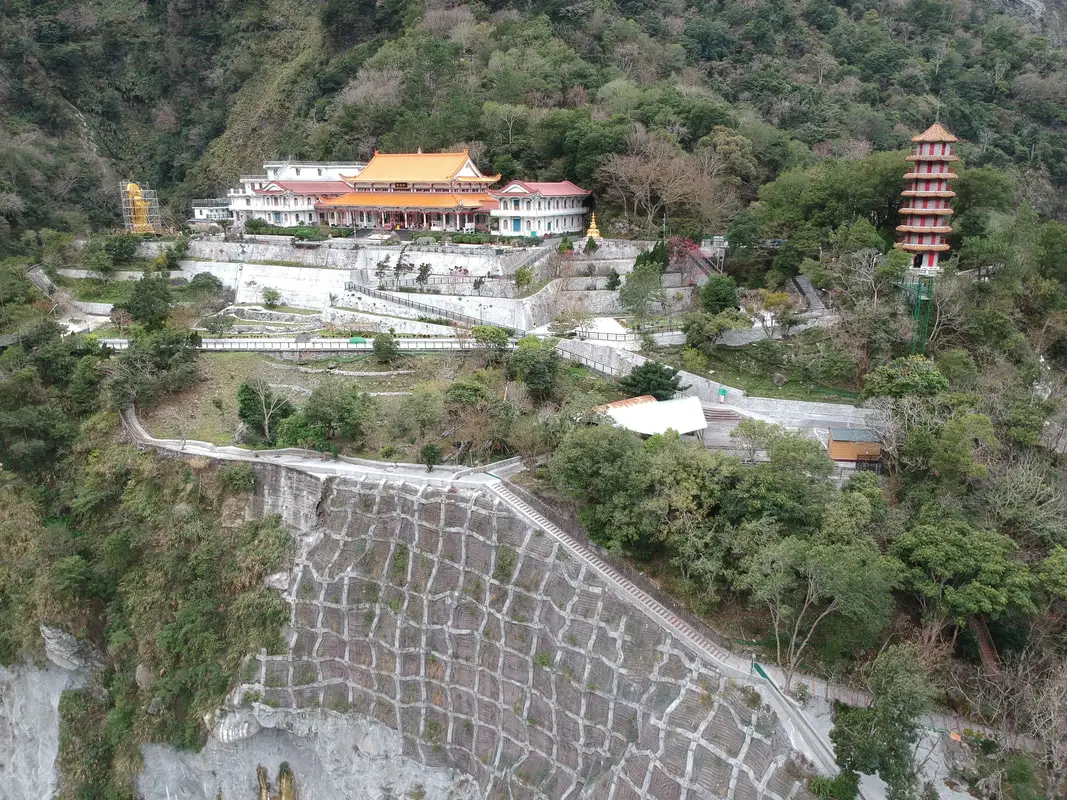
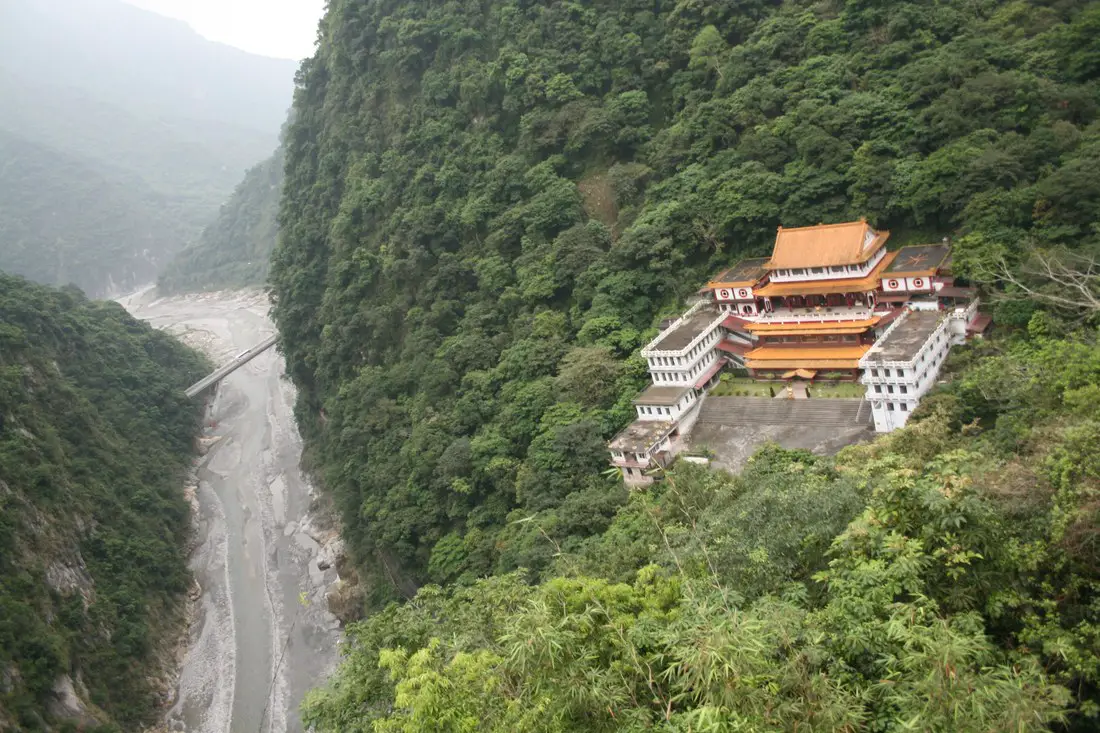
Tianxiang Recreation Area features the widest and most flat terraces within Taroko Gorge. Here you can find Xiangde Temple, Tianfeng Pagoda, Pudu Suspension Bridge, and Silks Place Taroko, which are all surrounded by amazing high canyons and beautiful deep river ravines. It is a must see spot inside Taroko Gorge.
Background: Taroko National Park is well known for its marble cliffs and canyons, and is also known as "The Marble Gorge." Millions of years ago, the rock we see today was sediment at the bottom of the Pacific Ocean, but oceanic and tectonic pressure turned it into limestone, and later into marble. Later the Eurasian plate was uplifted where Taiwan is today, and a gorge was cut out of the limestone thanks to the Liwu River. Taroko means "human being," from the Truku tribal language. Originally the Tupido Tribe settled in the area of what is now Tianxiang Taiti mesa. They built the Tupido Tribe Trail which was only 30 cm wide, and resided there until they were massacred by the Japanese in 1914. In 1917, the Japanese expanded the original trail made by the Tupido Tribe to 1.5 M and forced aboriginal tribesmen to carry goods along the trail to the east coast. This is now the Zhuilu Old Trail. Currently only 3km of the trail is open to the public. The Japanese created a national park in the Area in 1937, which was disestablished by the ROC in 1945, and then reenstated in as a national park in 1986. Tianxiang lies 455 meters above seas level, and lies at the convergence of the Dasha River and the Tazijili River, forming the Liwu River. Xiangde Temple was built in 1966 shortly after the central cross island highway was finished. It is a Buddhist monetary, and the area was chosen for it's quiet beauty. How to get there: By Car: From Taipei, Take National Highway 5 to Yilan and then drive on the Suhua Highway 9 to Hualien. A few miles before Hualien City, the gorge will be on your right. Tianxiang is 18 KM in. Looking for a scooter rental in Hualien? You can search KKday here or Klook here to look for options. You can also check out our scooter rental guide here. If you are looking for car rentals in Hualien, you can also search Klook here or KKDay here. You can also check out our car rental guide here. By Train: Take the train to Hualien station, and from there you can rent a scooter or car, or take a tour bus to the gorge, and then get off at Tianxiang. You can book tickets to travel to Hualien via inter-city bus on Klook here. Book tickets via the normal train (TRA) on Klook here. For more travel information see here. Where to stay? Most of the accommodation you will find is near the city center. If you only want to visit Hualien City and Taroko Gorge, you can consider booking a hotel near downtown, walking or cycling around the city, and taking a bus to Taroko Gorge. We have stayed at and recommend Dream Taiwan Homestay (Agoda / Booking.com / Expedia / Hotels.com), a high quality hostel for the money in downtown Hualien, Farglory Hotel (Agoda / Booking.com / Expedia / Hotels.com), right next to Farglory Ocean Park with amazing views of Hualien, and Goldenflower B&B (Agoda / Booking.com) in Yuli right next to Sixty Stone Mountain. You can find out where to stay in our Taiwan hotels guide or search for the best hotel deals in Taiwan here. You can also book Wifi and SIM cards for Taiwan on Gigago here. Need travel insurance? Compare prices on Insubuy here. Tours: You can find tours of Tianxiang on Klook here or KKday here. You can find more tours and activities in Hualien such as Surfing, Paragliding, SUP / Paddle Boarding, Kayaking, Canoeing, River Tracing, and much more on Klook here or KKday here. Hours: 24/7 Flying a Drone? Apply for a drone permit here. Price: Free! Map: Please see below: 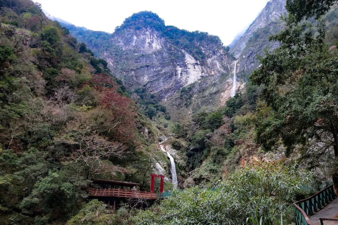
Baiyang Falls are a beautiful set of waterfalls in Taroko National Park. The trail is only 2 KM long and is flat and paved with no steps. It is an easy and relaxing way to enjoy some of the best scenery in the park.
Background: Taroko National Park is well known for its marble cliffs and canyons, and is also known as "The Marble Gorge." Millions of years ago, the rock we see today was sediment at the bottom of the Pacific Ocean, but oceanic and tectonic pressure turned it into limestone, and later into marble. Later the Eurasian plate was uplifted where Taiwan is today, and a gorge was cut out of the limestone thanks to the Liwu River. Taroko means "human being," from the Truku tribal language. Originally the Tupido Tribe settled in the area of what is now Tianxiang Taiti mesa. They built the Tupido Tribe Trail which was only 30 cm wide, and resided there until they were massacred by the Japanese in 1914. In 1917, the Japanese expanded the original trail made by the Tupido Tribe to 1.5 M and forced aboriginal tribesmen to carry goods along the trail to the east coast. This is now the Zhuilu Old Trail. Currently only 3km of the trail is open to the public. The Japanese created a national park in the Area in 1937, which was disestablished by the ROC in 1945, and then reinstated in as a national park in 1986. The road to Baiyang Waterfall was created by the Taipower Company in an effort to build a hydropower reservoir in Taroko Gorge. However the project was not completed, to protect the natural scenery in the area. The roads and tunnels left over from the project now make up the current trail, to what would normally be an arduous hike through impossible terrain. Baiyang Waterfall is 220 meters high, and the highest waterfall in Taiwan to fall off one sheer cliff. When to visit? Hualien is great year round, but it can get a little hot in the summer, and Typhoon season and heavy rain season last from about May to October. If you are afraid of the heat and rain then you can visit during winter when the temperatures are mild and the climate is usually dryer. Where to stay? Most of the accommodation you will find is near the city center. If you only want to visit Hualien City and Taroko Gorge, you can consider booking a hotel near downtown, walking or cycling around the city, and taking a bus to Taroko Gorge. We have stayed at and recommend Dream Taiwan Homestay (Agoda / Booking.com / Expedia / Hotels.com), a high quality hostel for the money in downtown Hualien, Farglory Hotel (Agoda / Booking.com / Expedia / Hotels.com), right next to Farglory Ocean Park with amazing views of Hualien, and Goldenflower B&B (Agoda / Booking.com) in Yuli right next to Sixty Stone Mountain. You can find out where to stay in our Taiwan hotels guide or search for the best hotel deals in Taiwan here. You can also book Wifi and SIM cards for Taiwan on Gigago here. Need travel insurance? Compare prices on Insubuy here. How to get there: By Car: From Taipei, Take National Highway 5 to Yilan and then drive on the Suhua Highway 9 to Hualien. A few miles before Hualien City, the gorge will be on your right. Keeping going until you reach the Baiyang Waterfall hike about 20 KM up the road. You can search KKday here or Klook here to look for options. You can also check out our scooter rental guide here. If you are looking for car rentals in Hualien, you can also search Klook here or KKDay here. You can also check out our car rental guide here. By Train: Take the train to Hualien station, and from there you can rent a scooter or car, or take a tour bus to the gorge, and get off at Baiyang Waterfall station. You can book tickets to travel to Hualien via inter-city bus on Klook here. Book tickets via the normal train (TRA) on Klook here. For more travel information see here. Tours: You can book a tour to Baiyang Falls on KKday here. Find more tours and activities in Hualien such as Surfing, Paragliding, SUP / Paddle Boarding, Kayaking, Canoeing, River Tracing, and much more on Klook here or KKday here. Hours: 24/7 Map: Please see below: |
Author 作家I am an American expat who has extensive experience living, working, and traveling in Taiwan. In my day, I had to learn many things about Taiwan the hard way. But I have come to learn that Taiwan is one of the best places in the world for Foreigners to live. This blog does not represent the opinions of every foreigner in Taiwan. I am just trying to help others learn more about this beautiful country. Categories
|
 RSS Feed
