

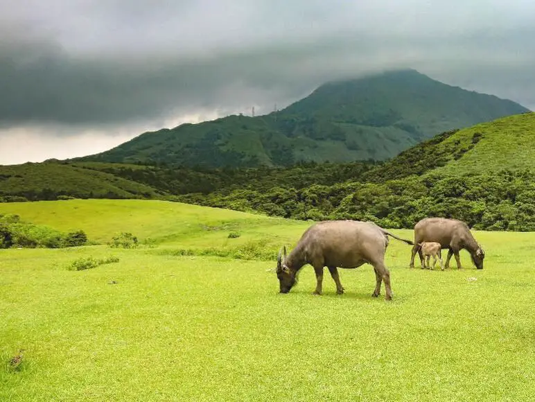
Qingtiangang in Yangmingshan National Park is a large grassland that lies on top of an old lava terrace. It is famous for the water buffalo that congregate here to graze and is one of the most popular areas in the park. Besides enjoying views of wild water buffalo, there are also many hiking trails and historic trails nearby. Overall it is a family-friendly destination and one of the most popular attractions in Taipei City.
Background: Qingtiangang, literally meaning "Hill Holding up Heaven" gets its name from the KMT Qingtian garrison that once guarded the hills and grasslands here. Officially it lies in Shilin District of Taipei, but parts of the grassland also lie in Jinshan District of New Taipei. The grassland lies 770 meters above sea level. The area known as Yangmingshan now was formed by volcanoes about 700,000 years ago, forming many mountains about 1000 meters or less in northwestern Taiwan. The park still features active volcanoes, vents, and hot springs. The original name of the area was Caoshan (grass mountain 草山). During the Qing Dynasty, the area was used to harvest sulfur, and many of the hills were burned to help catch sulfur thieves, Qingtiangang likely being one of these areas. Sulfur mining at Dayoukeng Crater in Yangmingshan National Park started in the Qing Dynasty by a British mining company who first obtained the rights to mine here in 1897. Currently you can find lots of old mining equipment that were abandoned here. The Yulu Old Trail was built near Dayoukeng to transport mining materials, and extended over to Qingtiangang. Mining sulfur ended with the formation of Yangmingshan National Park. In 1927 during the Japanese era, Yangmingshan was made as the first national park in Taiwan, then known as Datunshan National Park Association. The area around Qingtiangang to Lengshuikeng was made into a ranch for water buffalo, and grass from Japan was planted here for them to graze. In 1950 after the ROC took Taiwan, Chiang Kai-shek renamed the park after the philosopher Wang Yangming, and called the area Yangmingshan. The KMT kept the ranch at Qingtiangang and continued to maintain it. They also built bunkers here and kept a garrison of troops. In 1985, after resolving many land disputes, Yangmingshan National Park was officially designated as a national park in the ROC era. In2018, a mother died after being pushed over by a water buffalo at Qingtiangang. In 2020, the family was awarded NT$3.96 million from the park and wooden fences were built around the grasslands shortly after. The water buffalo at Qingtiangang are actually closely watched and cared for. Although they roam free around Yangmingshan, they are watched over by the Agricultural Associations of Jinshan, Shilin, Yangmingshan, and Beitou, and well as the national park management. In the winter of 2020 which was unusually wet, tens of cows began to die of malnutrition, therefore the park took steps to supplement the diet of the remaining cattle. Many cows were brought to lower eve lavations for rehabilitation before being released back to Yangmingshan. Due to its easy accessibility and nearby attractions such as Lengshuikeng and Qixingshan, it is a popular stop in Yangmingshan and has a parking lots and a visitor's center. In addition, it is one of the most popular tourist destinations in Taipei City. Hours: The visitor's center is open from 9 AM to 4:30 PM. Price: Free (car parking 30-50 NT, scooter parking 20 NT) You can book tours to Yangmingshan on TripAdvisor here, Klook here, or KKday here or here. Tours: You can check out tours to Yangmingshan such as a One-day Yangmingshan NP Beitou Hot Spring Park and Tamsui Tour Package, Beitou and Yangmingshan Day Tour from Taipei, One Day Hike around Yangmingshan, or Private Yangmingshan Volcano Tour and more on TripAdvisor here, Klook here, or KKday here. Hotels in Taipei: High end: We have stayed at and recommend the Yuanshan Grand Hotel, once the tallest building in Taiwan and still the most grand (book on Booking.com here, Tripadvisor here, or Agoda here). We also recommend Fullon Hotel which has locations in Tamsui and Fulong near the beach (book on Booking.com here, Tripadvisor here, Agoda here, or Hotels.com here). Budget Hotels: We have stayed at and also recommend Fu Chang Hotel in Ximending, which is within walking distance of Ximending shopping district (book on Booking.com here, Tripadvisor here, or Agoda here). We have also stayed at and recommend Hai Xia Your Home which is right in front of Fulong Beach (book on Booking.com here, Tripadvisor here, Agoda here, or Hotels.com here). Looking for a hotel? We recommend booking through Booking.com here, which provides the best quality selection of accommodation in Taiwan. Find out where to stay in our Taiwan hotels guide or search for the best hotel deals in Taiwan here. How to get there: By Car/Scooter: From Taipei, take provincial highway 2A north to the Zhuzihu Lookout. Keep right until you reach the turnoff the the Qingtiangang parking lot. Car parking is limited on weekends and the number of cars allowed up the mountain is also limited. There is also paid scooter parking. On weekends this place can be the most popular place in the park, and cars can be backed up for up to an hour or more, so consider taking a scooter or bus. Looking for scooter rental in Taipei? Check out Qeeq here, Klook here, or KKday here to search for options. You can also check out our scooter rental guide here. If you are looking for car rentals, you can also search Qeeq here, Klook here, or KKday here. You can also check out our car rental guide here. By Bus: From Beitou MRT Station, Take Little Bus 9 (小9) to Qingtiangang Station (擎天崗). You can book tickets to travel to Taipei via inter-city bus on Klook here. By Bicycle: Cycling is the best way to enjoy Taiwan's landscapes if you have the time and energy. Looking for bicycle rentals in Taiwan? You can use Taiwan's many Youbike sharing stations, or search for rentals on KKday here, and search for tours on Klook here. You can also check out our Taiwan cycling guide here. ​You can also book a Sunset Riverside Bike Ride and Historical Tour, 4 Hour Cycling in Taipei, Ultimate 8-Hour Cycling City Tour, or Taipei City Bike Tour with Night Market Experience on TripAdvisor here. Map: Please see below:
0 Comments
Yangmingshan National Park is a mountainous area in Taipei and New Taipei, known for its volcanic activity, hiking trails, wildlife, waterfalls, hot springs, and sulfur vents. It is definitely worth a stop on your trip to Taipei.
Historical Background: The area known as Yangmingshan now was formed by volcanoes about 700,000 years ago, forming many mountains about 1000 meters or less in northwestern Taiwan. The park still features active volcanoes, vents, and hot springs. The original name of the area was Caoshan (grass mountain 草山). During the Qing Dynasty, the area was used to harvest sulfur, and many of the hills were burned to help catch sulfur thieves, Qingtiangang likely being one of these areas. Sulfur mining was started in the Qing Dynasty by a British mining company that first obtained the rights to mine here in 1897. In 1927 during the Japanese era, Yangmingshan was made as the first national park in Taiwan, then known as Datunshan National Park Association. The area around Qingtiangang to Lengshuikeng was made into a ranch for water buffalo, and grass from Japan was planted here for them to graze. In 1950 after the ROC took Taiwan, Chiang Kai-shek renamed the park after the philosopher Wang Yangming, and called the area Yangmingshan. The KMT kept the ranch at Qingtiangang and continued to maintain it. They also built bunkers here and kept a garrison of troops. In 1985, after resolving many land disputes, Yangmingshan National Park was officially designated as a national park in the ROC era. Due to its easy accessibility from Taipei and many natural attractions, it is one of the most popular tourist destinations in Taipei City. Most visitors come on weekends, and it has parking lots and visitor's centers throughout the park. Hours: The visitor's centers are open from 9 AM to 4:30 PM. However you can visit the park 24/7. Price: Free entrance into the park (car parking 30-50 NT, scooter parking 20 NT) You can book tours to Yangmingshan on TripAdvisor here, Klook here, or KKday here or here. Tours: You can check out tours to Yangmingshan such as a One-day Yangmingshan NP Beitou Hot Spring Park and Tamsui Tour Package, Beitou and Yangmingshan Day Tour from Taipei, One Day Hike around Yangmingshan, or Private Yangmingshan Volcano Tour and more on TripAdvisor here, Klook here, or KKday here. When to Go: Silver Grass Season: Mang Grass season goes from September to November. During this time you will be able to see silvery grass all over the mountain tops around the park. Cherry Blossom Season: Cherry blossoms can be seen in the park from February to late March. Snowfall: Once every few years it can snow here from December to February. The snow usually only lasts a day or two and melts away quickly. Best Weather: In my opinion, the best weather is in the summer when constant rain makes the air cleaner, and summer mornings are usually clear. Be sure to start hiking in the morning for the best views and sunshine, as afternoon thundershowers are common. Hotels in Taipei: High end: We have stayed at and recommend the Yuanshan Grand Hotel, once the tallest building in Taiwan and still the most grand (book on Booking.com here, Tripadvisor here, or Agoda here). We have also stayed at and recommend the Grand Hyatt (book on Booking.com here, Tripadvisor here, Agoda here, or Hotels.com here), Marriot (book on Booking.com here, Tripadvisor here, Agoda here, or Hotels.com here), Sheraton (book on Booking.com here, Tripadvisor here, Agoda here, or Hotels.com here), Shangri-la (book on Booking.com here, Tripadvisor here, Agoda here, or Hotels.com here), and Regent (book on Booking.com here, Tripadvisor here, Agoda here, or Hotels.com here), which are all very high quality hotels in the middle of Taipei City. We also recommend Fullon Hotel which has locations in Tamsui and Fulong near the beach (book on Booking.com here, Tripadvisor here, Agoda here, or Hotels.com here). Budget Hotels: We have stayed at and also recommend Fu Chang Hotel in Ximending, which is within walking distance of Ximending shopping district (book on Booking.com here, Tripadvisor here, or Agoda here). We have also stayed at and recommend Hai Xia Your Home which is right in front of Fulong Beach (book on Booking.com here, Tripadvisor here, Agoda here, or Hotels.com here). Looking for a hotel? We recommend booking through Booking.com here, which provides the best quality selection of accommodation in Taiwan. Find out where to stay in our Taiwan hotels guide or search for the best hotel deals in Taiwan here. How to get there: By Car/Scooter: From Taipei, take provincial highway 2A north to the park, where you can see the main attractions such as Zhuzihu, Qixingshan, Datunshan, Qingtiangang, etc. There are many parking lots, but car parking is limited on weekends and the number of cars allowed up the mountain is also limited. There is also paid scooter parking. On weekends this place can be packed, and cars can be backed up for up to an hour or more, so consider taking a scooter or bus. Looking for scooter rental in Taipei? Check out Qeeq here, Klook here, or KKday here to search for options. You can also check out our scooter rental guide here. If you are looking for car rentals, you can also search Qeeq here, Klook here, or KKday here. You can also check out our car rental guide here. By Bus: From Beitou MRT Station, Take Little Bus 19 (小19), or another bus to the park. You can book tickets to travel to Taipei via inter-city bus on Klook here. You can book tickets to Taipei via high speed rail (HSR) on Klook here or KKDay here. By Bicycle: Cycling is the best way to enjoy Taiwan's landscapes if you have the time and energy. Looking for bicycle rentals in Taiwan? You can search on KKday here and search for tours on Klook here. You can also check out our Taiwan cycling guide here. Map: See below for a map of places mentioned in this blog: 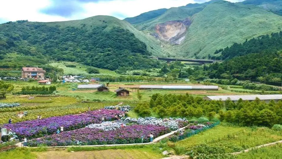
Zhuzihu is a small valley in Yangmingshan National Park (陽明山國家公園 Yángmíng shān guójiā gōngyuán, in Beitou District of Taipei City) between Qixing Mountian and Datun Mountian. The valley is especially fertile due to the rich volcanic soil and abundant rain, and the entire area is full of recreational farms which have become popular tourist destinations. You should definitely stop by on your trip to Yangmingshan.
Background: Zhuzihu valley (竹子湖 Zhúzi hú) was formed from lava that flowed out from Datunshan (大屯山 Dà tún shān) and Xiaoguanyinshan (小觀音山 Xiǎo guānyīn shān). Due to its location as a high mountain valley, it rains easily here; annual rain accumulation is about 4500 mm. Before Chinese settlers came to this valley, it was simply a road from the Taipei Basin to the coast, and a hunting ground. In the early 1600s, the first Chinese settlers came to farm here in three main family groups. In 1895, a brief skrimish was fought here between the Japanese and local settlers who did not want to be part of the Japanese empire. The Japanese built hot springs here, experimental farms, a library, and a hiking dormitory. They began planting cabbage and rice here. After the ROC took over Taiwan, cabbage growing became less important, and the farmers here began planting flowers and catering to tourism instead. Now Zhuzihu is one of the most popular spots in Taipei to see flower gardens, mainly white and purple Arum-lilys (海芋 Hǎiyù) and Hydrangea (繡球花 Xiùqiú huā) which bloom from about February to June. Hours: 8 AM to 5 PM (March 27th to June 21st, in 2025) When to go: From late February to early June, when the Arum-lilys and Hydrangea are in bloom. (竹子湖海芋季; 竹子湖繡球花季) Price: 100 NT per person (can be used to purchase drinks, food, other merchandise) You can book tours to Yangmingshan on TripAdvisor here, Klook here, or KKday here or here. Tours: You can check out tours to Yangmingshan such as a One-day Yangmingshan NP Beitou Hot Spring Park and Tamsui Tour Package, Beitou and Yangmingshan Day Tour from Taipei, One Day Hike around Yangmingshan, or Private Yangmingshan Volcano Tour and more on TripAdvisor here, Klook here, or KKday here. Hotels in Taipei: High end: We have stayed at and recommend the Yuanshan Grand Hotel, once the tallest building in Taiwan and still the most grand (book on Booking.com here or Agoda here). We also recommend Fullon Hotel which has locations in Tamsui and Fulong near the beach (book on Booking.com here or Agoda here). Budget Hotels: We have stayed at and also recommend Fu Chang Hotel in Ximending, which is within walking distance of Ximending shopping district (book on Booking.com hereor Agoda here). We have also stayed at and recommend Hai Xia Your Home which is right in front of Fulong Beach (book on Booking.com here or Agoda here). Looking for a hotel? We recommend booking through Booking.com here, which provides the best quality selection of accommodation in Taiwan. Find out where to stay in our Taiwan hotels guide or search for the best hotel deals in Taiwan here. How to get there: By Car/Scooter: From Taipei, take provincial highway 2A north to the Zhizihu Lookout. At the roundabout, stay to the left off the main highway and then keep right until you reach the valley. Car parking is limited on weekends and the number of cars allowed up the mountain is also limited. There is free scooter parking everywhere. Looking for scooter rental in Taipei? Check out Qeeq here, Klook here, or KKday here to search for options. You can also check out our scooter rental guide here. If you are looking for car rentals, you can also search Qeeq here, Klook here, or KKday here. You can also check out our car rental guide here. By Bus: From Beitou MRT Station, Take Little Bus 9 (小9) to Fengjiakou Station (風架口). You can book tickets to travel to Taipei via inter-city bus on Klook here. By Bicycle: Cycling is the best way to enjoy Taiwan's landscapes if you have the time and energy. Looking for bicycle rentals in Taiwan? You can use Taiwan's many Youbike sharing stations, or search for rentals on KKday here, and search for tours on Klook here. You can also check out our Taiwan cycling guide here. Map: Please see below: 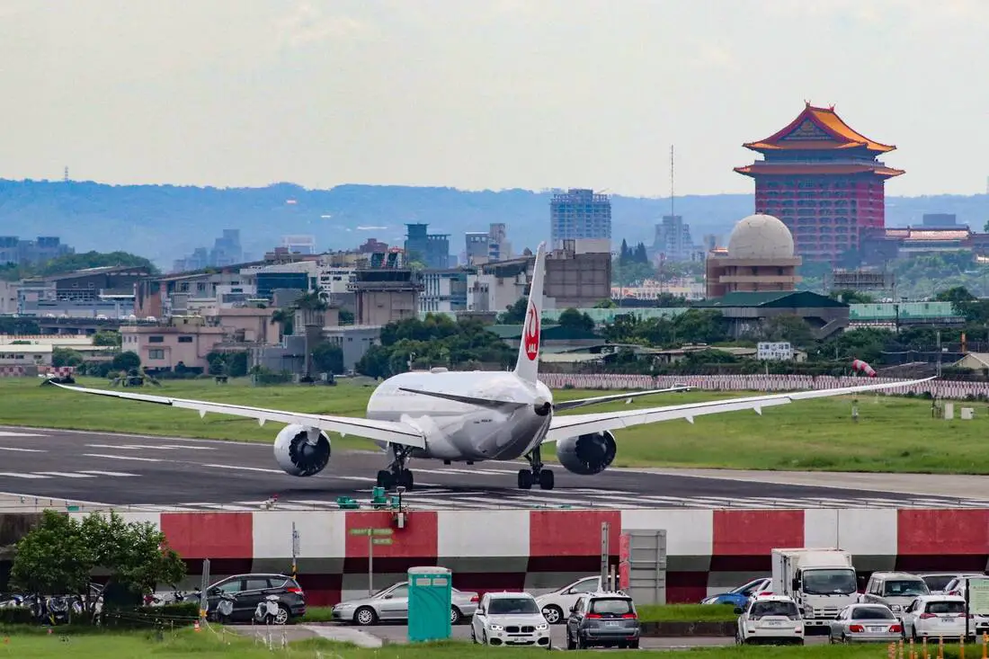
Neihu Sports Park is one of the best parks in Taipei. Besides a rock climbing wall, skate park, track, water splashing area, baseball fields, a large playground area, and plenty of grass, there is also a viewing platform directly in front of the Songshan Airport that lets you see airplanes land and take off from a close distance.
Background: Neihu Sports Park was completed in 2002, and was built above the Neihu Wastewater Treatment Plant. It features a rock climbing wall, skate park, rubber track, water park, baseball fields, a large playground area, sand pit, and plenty of grass. There is also a viewing platform directly in front of the Songshan Airport that lets you see airplanes land and take off from a close distance, which connects to the Keelung Riverside Park. Price: Free Hours: 24/7 How to get there: By Bus: From central Taipei, take bus GR16 to the park. By Car/Scooter: From central Taipei, go on Minquan Road east until you pass the bridge into Neihu. Then turn left on Jiuzong Raod. There is limited scooter parking at the entrance. There is also paid car parking on the opposite side of the park. Map: Please see below: 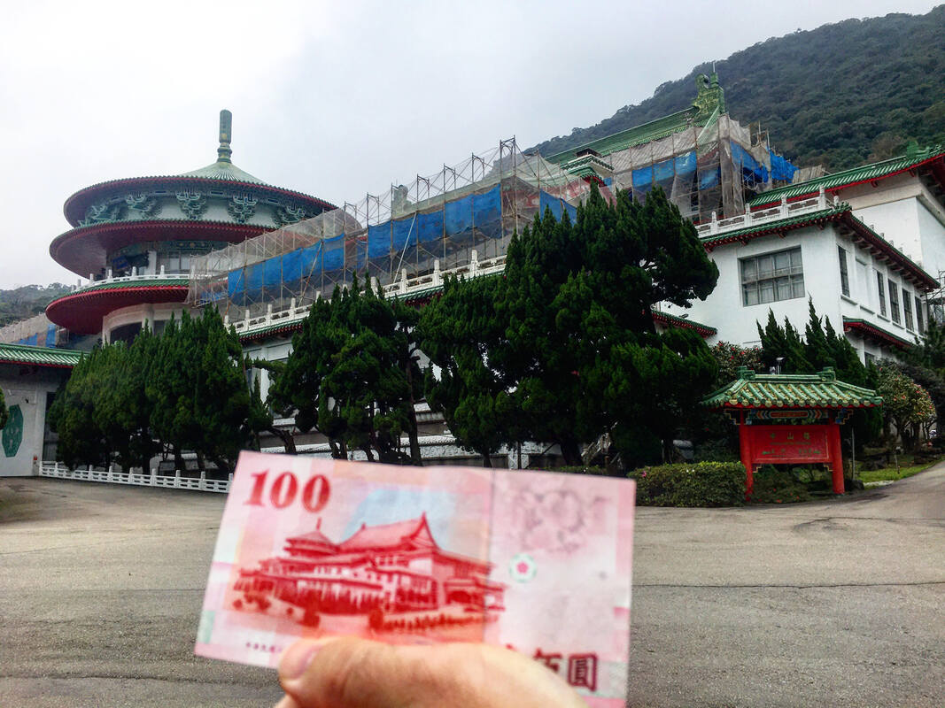
You may recognize the Chungshan Building from the back of the 100 NT dollar bill. Originally built as a meeting place for the now defunct National Assembly, the building is now rarely used for events. The fact that is the only building in the world built right on top of a sulfur vent means that it is hard to maintain, and many parts of the building are under constant repair. However it is full of precocious art and beautiful architecture, and it is open daily for tours.
Background: The land that the Chunghsan Building Currently rests on an active sulfur vent, formerly known as the Caoshan Hot Springs. During the Japanese era, this place was home to an elementary school and was the source of hot spring water for local hot spring hotels (and still is). After the KMT took Taiwan, the reason this location was chosen by Chiang Kai-shek for a government building was because of the locations remarkable Fengshui. The location aligns perfectly with nearby mountains and valleys to create the perfect stream for Fenshui to flow. The Chungshan Building started construction in October 1965 and was completed in November 1966, with construction time totaling only 13 months. This was due to planning from the architect Ms. Xiu Zelan (修澤蘭) and the backbreaking nonstop labor from the KMT military, which would be sure to break all labor laws today. Another reason for the speedy completion was that it was needed to be ready to commemorate the 100th birthday of the father of the ROC, Sun Yat-sen. In order to cope with the constant sulfur vents steaming out of the mountain, the building is equipped with giant exhaust pipes that go through the center of the building. This also helps to keep the building warm in winter. The foundations of the building go down 12 meters into the sulfur soil, and are coated with tar and aluminum to prevent corrosion. Also, much of the building is plated with pure gold to prevent corrosion. This is the only building in the world built on top of a sulfur vent. The building was meant to be the place for the National Assembly to meet, and also a place to show off the elegance of China to foreign dignitaries. Taiwan was thrown out of the U.N. in 1971, after which many fewer foreign heads of state visited Taiwan. The National Assembly was established in 1948 to elect the president of the Republic of China. Its power was then granted to the legislative Yuan and the Taiwanese people in the 1990s, in the wake of free elections in Taiwan, and it was officially disbanded in 2005, meaning the building no longer served any real purpose. Also in 2005, it was declared a national historical monument. The assembly hall as capacity for 1800 people and the cafeteria has room for 2000 people. Besides paid tours daily, sometimes presidential events and art exhibitions are held here. Price: 80 NT You can book a private tour to the Chungshan building on Klook here. Tours: You can book a private tour to the Chungshan building on Klook here. You can check out tours to Yangmingshan such as a One-day Yangmingshan NP Beitou Hot Spring Park and Tamsui Tour Package, Beitou and Yangmingshan Day Tour from Taipei, One Day Hike around Yangmingshan, or Private Yangmingshan Volcano Tour and more on TripAdvisor here, Klook here, or KKday here. Hours: Tour times are 9:00 AM, 10:30 AM, 1:30 PM, and 3 PM daily and the tour lasts about an hour and a half. I highly recommend it. Be sure to get there about 10 minutes early. Be wary that for some national holidays the building is closed to the public. Hotels in Taipei: High end: We have stayed at and recommend the Yuanshan Grand Hotel, once the tallest building in Taiwan and still the most grand (book on Booking.com here, Tripadvisor here, or Agoda here). We also recommend Fullon Hotel which has locations in Tamsui and Fulong near the beach (book on Booking.com here, Tripadvisor here, Agoda here, or Hotels.com here). Budget Hotels: We have stayed at and also recommend Fu Chang Hotel in Ximending, which is within walking distance of Ximending shopping district (book on Booking.com here, Tripadvisor here, or Agoda here). We have also stayed at and recommend Hai Xia Your Home which is right in front of Fulong Beach (book on Booking.com here, Tripadvisor here, Agoda here, or Hotels.com here). Looking for a hotel? We recommend booking through Booking.com here, which provides the best quality selection of accommodation in Taiwan. Find out where to stay in our Taiwan hotels guide or search for the best hotel deals in Taiwan here. How to Get There: By Bus: Take bus 260 from Shilin Station. The bus ride to the Chungshan Station stop takes about an hour. You can book tickets to travel to Taipei via inter-city bus on Klook here. By Car/Scooter: Drive up provincial Highway 2A up into Yangmingshan National Park. The building sits at the intersection between Highway 2A and Yangjin Highway. There is free parking in front of the building. Looking for scooter rental in Taipei? Check out Qeeq here, Klook here, or KKday here to search for options. You can also check out our scooter rental guide here. If you are looking for car rentals, you can also search Qeeq here, Klook here, or KKday here. You can also check out our car rental guide here. By Bicycle: Cycling is the best way to enjoy Taiwan's landscapes if you have the time and energy. Looking for bicycle rentals in Taiwan? You can use Taiwan's many Youbike sharing stations, or search for rentals on KKday here, and search for tours on Klook here. You can also check out our Taiwan cycling guide here. ​You can also book a Sunset Riverside Bike Ride and Historical Tour, 4 Hour Cycling in Taipei, Ultimate 8-Hour Cycling City Tour, or Taipei City Bike Tour with Night Market Experience on TripAdvisor here. Map: Please see below: 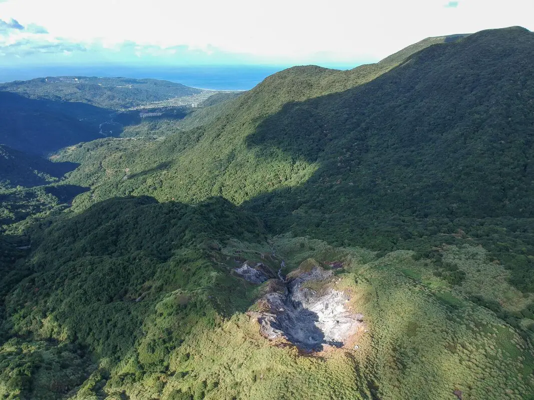
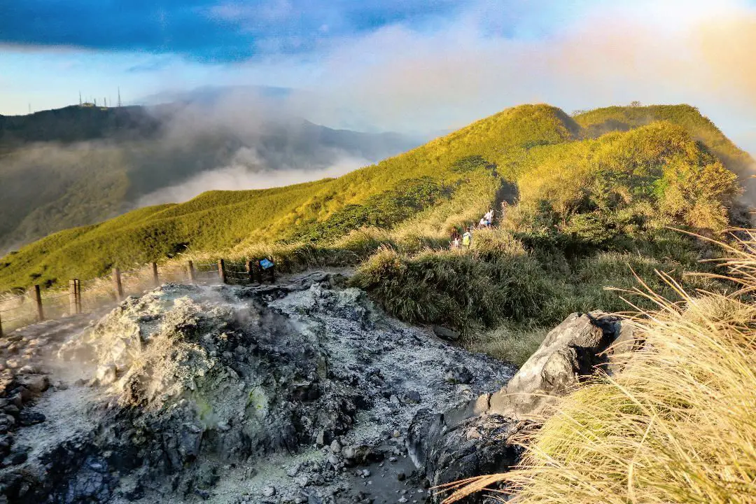
The Dayoukeng Crater in Yangmingshan National Park is the biggest sulfur vent area in Taiwan, and would likely be the first place to spew lava in the event of a volcanic eruption. This along with Turtle Island are the two known active volcanos in Taiwan. The area was also an important historical sulfur mine. Currently access to Dayoukeng is closed, but you can fly a drone hear with a permit.
Background: The area known as Yangmingshan now was formed by volcanoes about 700,000 years ago, forming many mountains about 1000 meters or less in northwestern Taiwan. The park still features active volcanoes, vents, and hot springs. The original name of the area was Caoshan (grass mountain 草山). During the Qing Dynasty, the area was used to harvest sulfur, and many of the hills were burned to help catch sulfur thieves. In 1927 during the Japanese era, Yangmingshan was made as the first national park in Taiwan, then known as Datunshan National Park Association. In 1950 after the ROC took Taiwan Chiang Kai-shek renamed the park after the philosopher Wang Yangming, and called the area Yangmingshan. In 1985, after resolving many land disputes, Yangmingshan National Park was officially designated as a national park in the ROC era. Dayoukeng (literally "Big Oil Crater" gets its name because the there are two main sulfur vents on Yangmingshan, and it is the biggest sulfur vent area in Taiwan. Temperatures here can reach 120 degrees celcious, and the water is very acidic with a PH level of only 1-2. The venting crater lies about 805 meters above sea level. A few kilometers under the ground, there is a leftover lava chamber from a previous eruption that heats up ground water and sends it spewing back to the surface. Sulfur mining at Dayoukeng Crater in Yangmingshan National Park started in the Qing Dynasty by a British mining company who first obtained the rights to mine here in 1897. Currently you can find lots of old mining equipment that were abandoned here. The Yulu Old Trail was built near Dayoukeng to transport mining materials. Mining sulfur ended with the formation of Yangmingshan National Park. Dayoukeng lies in Jinshan District of New Taipei City. It is a popular stop in Yangmingshan and has two parking lots and visitor's center. It is also one of the starting points for the Mt. Qixing Trail. Hours: The visitor's center is open from 9 AM to 4:30 PM. Price: Free (parking 30 NT) You can book tours to Yangmingshan on TripAdvisor here, Klook here, or KKday here or here. Tours: You can check out tours to Yangmingshan such as a One-day Yangmingshan NP Beitou Hot Spring Park and Tamsui Tour Package, Beitou and Yangmingshan Day Tour from Taipei, One Day Hike around Yangmingshan, or Private Yangmingshan Volcano Tour and more on TripAdvisor here, Klook here, or KKday here. Hotels in Taipei: High end: We have stayed at and recommend the Yuanshan Grand Hotel, once the tallest building in Taiwan and still the most grand (book on Booking.com here, Tripadvisor here, or Agoda here). We also recommend Fullon Hotel which has locations in Tamsui and Fulong near the beach (book on Booking.com here, Tripadvisor here, Agoda here, or Hotels.com here). Budget Hotels: We have stayed at and also recommend Fu Chang Hotel in Ximending, which is within walking distance of Ximending shopping district (book on Booking.com here, Tripadvisor here, or Agoda here). We have also stayed at and recommend Hai Xia Your Home which is right in front of Fulong Beach (book on Booking.com here, Tripadvisor here, Agoda here, or Hotels.com here). Looking for a hotel? We recommend booking through Booking.com here, which provides the best quality selection of accommodation in Taiwan. Find out where to stay in our Taiwan hotels guide or search for the best hotel deals in Taiwan here. How to get there: By Car/Scooter: From Taipei, take provincial highway 2A north to the Zhuzihu Lookout. Keep right until you reach the turnoff the the Qingtiangang parking lot. Car parking is limited on weekends and the number of cars allowed up the mountain is also limited. There is also paid scooter parking. Looking for scooter rental in Taipei? Check out Qeeq here, Klook here, or KKday here to search for options. If you are looking for car rentals, you can also search Qeeq here, Klook here, or KKday here. You can also check out our car rental guide here. By Bus: From Beitou MRT Station, Take Little Bus 9 (小9) to Qingtiangang Station (擎天崗). You can book tickets to travel to Taipei via inter-city bus on Klook here. By Bicycle: Cycling is the best way to enjoy Taiwan's landscapes if you have the time and energy. Looking for bicycle rentals in Taiwan? You can use Taiwan's many Youbike sharing stations, or search for rentals on KKday here, and search for tours on Klook here. You can also check out our Taiwan cycling guide here. You can also book a Sunset Riverside Bike Ride and Historical Tour, 4 Hour Cycling in Taipei, Ultimate 8-Hour Cycling City Tour, or Taipei City Bike Tour with Night Market Experience on TripAdvisor here. Map: Please see below: 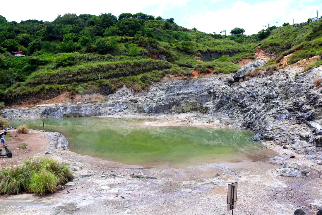
Longfeng Valley in Yangmingshan National Park is a large volcanic sulfur hot spring area with hiking trails, steam vents, sulfur deposits, and large natural hot springs. Longfeng Valley remains as a mostly untouched natural pool that retains its natural beauty without man made structures surrounding it. It is a unique and interesting stop on the mountain and worth a visit on your trip to Yangmingshan.
Background: The area known as Yangmingshan now was formed by volcanoes about 700,000 years ago, forming many mountains about 1000 meters or less in northwestern Taiwan. The park still features active volcanoes, vents, and hot springs. The original name of the area was Caoshan (grass mountain 草山). During the Qing Dynasty, the area was used to harvest sulfur, and many of the hills were burned to help catch sulfur thieves. In 1927 during the Japanese era, Yangmingshan was made as the first national park in Taiwan, then known as Datunshan National Park Association. In 1950 after the ROC took Taiwan Chiang Kai-shek renamed the park after the philosopher Wang Yangming, and called the area Yangmingshan. In 1985, after resolving many land disputes, Yangmingshan National Park was officially designated as a national park in the ROC era. The hot springs at Beitou were first converted into hot spring resorts in 1894, and Beitou become a popular hot spring location during the Japanese era, and there are many hot spring hotels and baths that exist there today. Longfeng Valley literally means "Dragon and Phoenix Valley." Longfeng Valley remains as a mostly untouched natural pool that retains its natural beauty without man made structures surrounding it. Hours: 24/7 Tours: You can book a Bath of the Gods Hot Spring Tour at Beitou, Taipei, 2-Hour Private Walking Tour in Beitou or Beitou and Yangmingshan Day Tour from Taipei and more on TripAdvisor here, Klook here, or KKday here. Hotels in Taipei: High end: We have stayed at and recommend the Yuanshan Grand Hotel, once the tallest building in Taiwan and still the most grand (book on Booking.com here, Tripadvisor here, or Agoda here). We also recommend Fullon Hotel which has locations in Tamsui and Fulong near the beach (book on Booking.com here, Tripadvisor here, Agoda here, or Hotels.com here). Budget Hotels: We have stayed at and also recommend Fu Chang Hotel in Ximending, which is within walking distance of Ximending shopping district (book on Booking.com here, Tripadvisor here, or Agoda here). We have also stayed at and recommend Hai Xia Your Home which is right in front of Fulong Beach (book on Booking.com here, Tripadvisor here, Agoda here, or Hotels.com here). Looking for a hotel? We recommend booking through Booking.com here, which provides the best quality selection of accommodation in Taiwan. Find out where to stay in our Taiwan hotels guide or search for the best hotel deals in Taiwan here. How to get there: By Bus: From Xinbeitou MRT station, take the 508 shuttle bus up the mountain to Dunu Vocational High School of Business, and then walk about five minutes down to the valley. You can book tickets to travel to Taipei via inter-city bus on Klook here. By Car/Scooter: From downtown Beitou, drive up Quanyuan Road until you reach Longfenggu Visitor's Center. You can park at the visitor's center or down in the valley below. Looking for scooter rental in Taipei? Check out Qeeq here, Klook here, or KKday here to search for options. You can also check out our scooter rental guide here. If you are looking for car rentals, you can also search Qeeq here, Klook here, or KKday here. You can also check out our car rental guide here. By Bicycle: Cycling is the best way to enjoy Taiwan's landscapes if you have the time and energy. Looking for bicycle rentals in Taiwan? You can use Taiwan's many Youbike sharing stations, or search for rentals on KKday here, and search for tours on Klook here. You can also check out our Taiwan cycling guide here. You can also book a Sunset Riverside Bike Ride and Historical Tour, 4 Hour Cycling in Taipei, Ultimate 8-Hour Cycling City Tour, or Taipei City Bike Tour with Night Market Experience on TripAdvisor here. Map: Please see below: 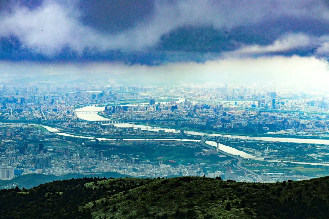
Datunshan in Yangmingshan National Park (aka Datun Mountain) is considered the only active volcanic peak in Taiwan, and the island's only stratovolcano. This along with Turtle Island are the two known active volcanos in Taiwan. The area is also an important ecological area with protected species. Currently access to Datunshan is closed to motor vehicles, but you can cycle or hike to the top. There is a large viewing platform that has great views of the Taipei Basin and the sunset.
Background: The area known as Yangmingshan now was formed by volcanoes about 700,000 years ago, forming many mountains about 1000 meters or less in northwestern Taiwan. The park still features active volcanoes, vents, and hot springs. The original name of the area was Caoshan (grass mountain 草山). During the Qing Dynasty, the area was used to harvest sulfur, and many of the hills were burned to help catch sulfur thieves. In 1927 during the Japanese era, Yangmingshan was made as the first national park in Taiwan, then known as Datunshan National Park Association. In 1950 after the ROC took Taiwan Chiang Kai-shek renamed the park after the philosopher Wang Yangming, and called the area Yangmingshan. In 1985, after resolving many land disputes, Yangmingshan National Park was officially designated as a national park in the ROC era. Datunshan is1092 meters tall, and is known as the only strata volcano in Taiwan. It is also known to snow in the area. Datunshan lies in Beitou District of New Taipei City. It is a popular stop in Yangmingshan and has two parking lots and visitor's center at Erziping. There is a paved road that goes to the top of the mountain. The tip of the mountain is off limits to the public and contains a weather station, but there is a large viewing platform that has great views of the Taipei Basin and the sunset. Hours: 24/7 Price: Free (parking 30 NT) You can book tours to Yangmingshan on TripAdvisor here, Klook here, or KKday here or here. Tours: You can check out tours to Yangmingshan such as a One-day Yangmingshan NP Beitou Hot Spring Park and Tamsui Tour Package, Beitou and Yangmingshan Day Tour from Taipei, One Day Hike around Yangmingshan, or Private Yangmingshan Volcano Tour and more on TripAdvisor here, Klook here, or KKday here. Difficulty: Easy: 247 meter elevation gain, 45 minutes to the top and 45 minutes back (1.5 hours round trip). There is a flat paved road to the top from Erziping, or a steeper trail from Anbu. Hotels in Taipei: High end: We have stayed at and recommend the Yuanshan Grand Hotel, once the tallest building in Taiwan and still the most grand (book on Booking.com here, Tripadvisor here, or Agoda here). We also recommend Fullon Hotel which has locations in Tamsui and Fulong near the beach (book on Booking.com here, Tripadvisor here, Agoda here, or Hotels.com here). Budget Hotels: We have stayed at and also recommend Fu Chang Hotel in Ximending, which is within walking distance of Ximending shopping district (book on Booking.com here, Tripadvisor here, or Agoda here). We have also stayed at and recommend Hai Xia Your Home which is right in front of Fulong Beach (book on Booking.com here, Tripadvisor here, Agoda here, or Hotels.com here). Looking for a hotel? We recommend booking through Booking.com here, which provides the best quality selection of accommodation in Taiwan. Find out where to stay in our Taiwan hotels guide or search for the best hotel deals in Taiwan here. How to get there: By Car/Scooter: From Taipei, take provincial highway 2A north to the Zhuzihu Lookout. Turn left at the fork to Datunshan, and keep going until you reach the first parking lot or second parking lot at Erziping. Car parking is limited on weekends and the number of cars allowed up the mountain is also limited. There is also paid scooter parking. I recommend coming up from the Anbu Trailhead to the east because there is less distance walking, but it is steeper. Looking for scooter rental in Taipei? Check out Qeeq here, Klook here, or KKday here to search for options. You can also check out our scooter rental guide here. If you are looking for car rentals, you can also search Qeeq here, Klook here, or KKday here. You can also check out our car rental guide here. By Bus: From Shilin MRT Station, Take Bus 1717 to Bailaka Highway Entrance Station (百拉卡公路入口). From there the trail entrance is about 1 KM away. You can book tickets to travel to Taipei via inter-city bus on Klook here. By Bicycle: Cycling is the best way to enjoy Taiwan's landscapes if you have the time and energy. Looking for bicycle rentals in Taiwan? You can use Taiwan's many Youbike sharing stations, or search for rentals on KKday here, and search for tours on Klook here. You can also check out our Taiwan cycling guide here. You can also book a Sunset Riverside Bike Ride and Historical Tour, 4 Hour Cycling in Taipei, Ultimate 8-Hour Cycling City Tour, or Taipei City Bike Tour with Night Market Experience on TripAdvisor here. Map: Please see below: 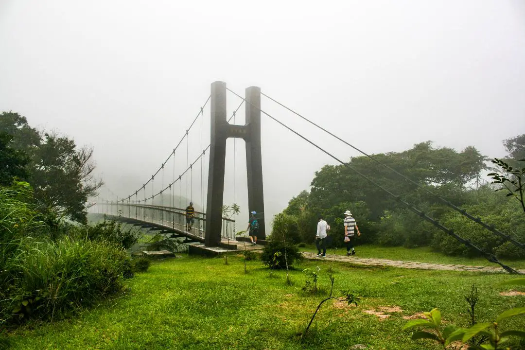
Lengshuikeng in Yangmingshan National Park is a small area with hiking trails, natural hot springs, waterfalls, and wildlife. Even though the name means "cold water hole," the water here is not cold, and there are plenty of hot springs around including a public hot spring bath house. It is a quiet a pleasant stop on the mountain and worth a visit on your trip to Yangmingshan.
Background: The area known as Yangmingshan now was formed by volcanoes about 700,000 years ago, forming many mountains about 1000 meters or less in northwestern Taiwan. The park still features active volcanoes, vents, and hot springs. The original name of the area was Caoshan (grass mountain 草山). During the Qing Dynasty, the area was used to harvest sulfur, and many of the hills were burned to help catch sulfur thieves. In 1927 during the Japanese era, Yangmingshan was made as the first national park in Taiwan, then known as Datunshan National Park Association. In 1950 after the ROC took Taiwan Chiang Kai-shek renamed the park after the philosopher Wang Yangming, and called the area Yangmingshan. In 1985, after resolving many land disputes, Yangmingshan National Park was officially designated as a national park in the ROC era. Lengshuikeng (literally "cold water crater" gets its name because the hot spring waters here are only 40 degrees centigrade, the coldest hot spring waters on Yangmingshan. Lengshuikeng has the only sulfur deposit sediment layer in Taiwan. Nearby are many hot springs and vents. It is a popular stop in Yangmingshan and has two parking lots and visitor's center. Hours: The visitor's center is open from 9 AM to 4:30 PM. Price: Free You can book tours to Yangmingshan on TripAdvisor here, Klook here, or KKday here or here. Tours: You can check out tours to Yangmingshan such as a One-day Yangmingshan NP Beitou Hot Spring Park and Tamsui Tour Package, Beitou and Yangmingshan Day Tour from Taipei, One Day Hike around Yangmingshan, or Private Yangmingshan Volcano Tour and more on TripAdvisor here, Klook here, or KKday here. How to get there: By Car/Scooter: From Taipei, take provincial highway 2A north to Chungshan Hall, and take a right, then continue down the road up the mountain to the left until you reach Lengshuikeng. Looking for scooter rental in Taipei? Check out Qeeq here, Klook here, or KKday here to search for options. You can also check out our scooter rental guide here. If you are looking for car rentals, you can also search Qeeq here, Klook here, or KKday here. You can also check out our car rental guide here. By Bus: From Shilin MRT Station, take bus S15 to Lengshuikeng Service Station. You can book tickets to travel to Taipei via inter-city bus on Klook here. By Bicycle: Cycling is the best way to enjoy Taiwan's landscapes if you have the time and energy. Looking for bicycle rentals in Taiwan? You can use Taiwan's many Youbike sharing stations, or search for rentals on KKday here, and search for tours on Klook here. You can also check out our Taiwan cycling guide here. You can also book a Sunset Riverside Bike Ride and Historical Tour, 4 Hour Cycling in Taipei, Ultimate 8-Hour Cycling City Tour, or Taipei City Bike Tour with Night Market Experience on TripAdvisor here. Map: Please see below: 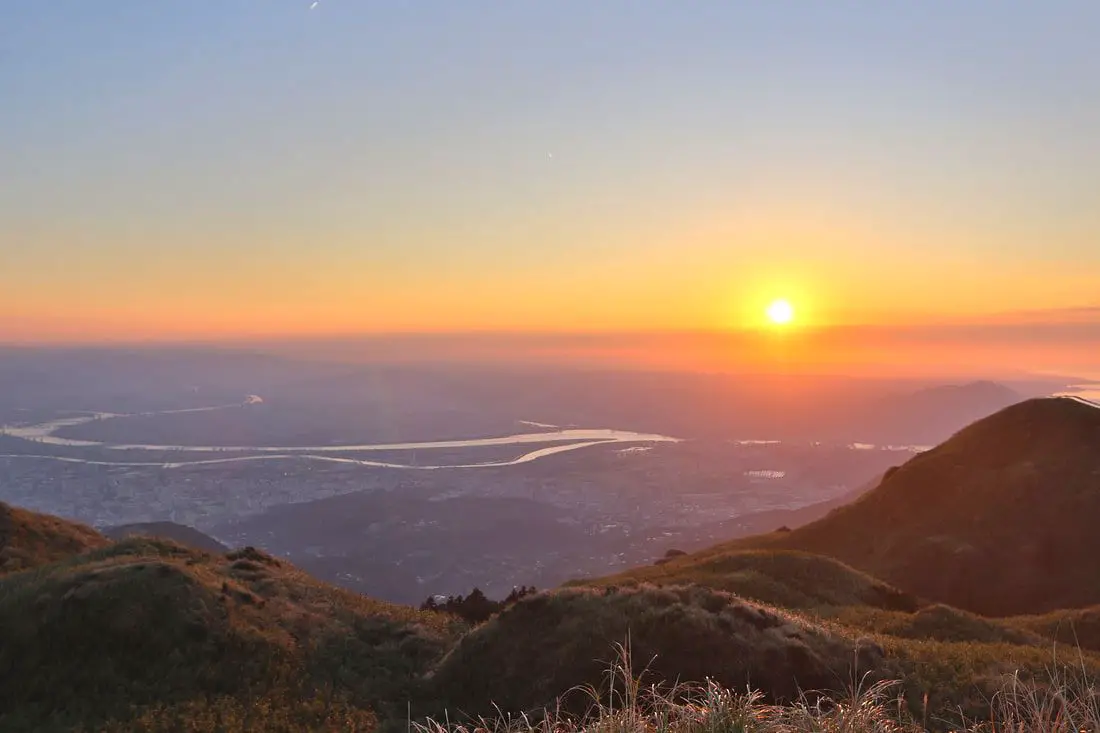
Qixingshan in Yangmingshan National Park (aka Qixing Mountain, Cising Mountain, Chising Mountain, or Seven Star Mountain) is considered the highest dormant volcanic peak in Taiwan, and the highest point in Taipei City. The area is also an important ecological area with protected species. There are a few paths to the top with varying difficulty, and it offers great views of the Taipei Basin and the sunset.
Background: The area known as Yangmingshan now was formed by volcanoes more than 700,000 years ago, forming many mountains about 1000 meters or less in northwestern Taiwan. The park still features active volcanoes, vents, and hot springs. The original name of the area was Caoshan (grass mountain 草山). During the Qing Dynasty, the area was used to harvest sulfur, and many of the hills were burned to help catch sulfur thieves. In 1927 during the Japanese era, Yangmingshan was made as the first national park in Taiwan, then known as Datunshan National Park Association. In 1950 after the ROC took Taiwan Chiang Kai-shek renamed the park after the philosopher Wang Yangming, and called the area Yangmingshan. In 1985, after resolving many land disputes, Yangmingshan National Park was officially designated as a national park in the ROC era. Qixingshan is 1120 meters tall, and is known as the highest dormant volcano in Taiwan. The last eruption here was about 700,000 years ago. Originally the peak had a crater but it slowly eroded into seven peaks, which is how it got its name. It is also known to snow in the area. Qixingshan lies in Beitou District of New Taipei City. It is a popular stop in Yangmingshan and has three main trails up to the top. There is a large viewing platform that has great views of the Taipei Basin and the sunset. Hours: 24/7 Price: Free (parking 30 NT) You can book tours to Yangmingshan on TripAdvisor here, Klook here, or KKday here or here. Tours: You can check out tours to Yangmingshan such as a One-day Yangmingshan NP Beitou Hot Spring Park and Tamsui Tour Package, Beitou and Yangmingshan Day Tour from Taipei, One Day Hike around Yangmingshan, or Private Yangmingshan Volcano Tour and more on TripAdvisor here, Klook here, or KKday here. Difficulty: There are three trails that you can take to the top. Here is a dissections of each trail: From Miaopu: Moderate: : 700 meter elevation gain, 2.4 KM of walking one way, 2 hours to the top and 2 hours back (4 hours round trip). This is the most difficult way up. From Xiaoyoukeng: Easy: 400 meter elevation gain, 1.6 KM walk one way, 40 minutes to the top and 40 minutes back (1.5 hours round trip). This is the easiest way up. From Lengshuikeng/Menghuan Pond: Easy: 450 meter elevation gain, 2.1 KM walk one way, 45 minutes to the top and 45 minutes back (1.5 hours round trip). For a more detailed comparison of the three trails, check out this blog by Josh Ellis. Hotels in Taipei: High end: We have stayed at and recommend the Yuanshan Grand Hotel, once the tallest building in Taiwan and still the most grand (book on Booking.com here, Tripadvisor here, or Agoda here). We also recommend Fullon Hotel which has locations in Tamsui and Fulong near the beach (book on Booking.com here, Tripadvisor here, Agoda here, or Hotels.com here). Budget Hotels: We have stayed at and also recommend Fu Chang Hotel in Ximending, which is within walking distance of Ximending shopping district (book on Booking.com here, Tripadvisor here, or Agoda here). We have also stayed at and recommend Hai Xia Your Home which is right in front of Fulong Beach (book on Booking.com here, Tripadvisor here, Agoda here, or Hotels.com here). Looking for a hotel? We recommend booking through Booking.com here, which provides the best quality selection of accommodation in Taiwan. Find out where to stay in our Taiwan hotels guide or search for the best hotel deals in Taiwan here. How to get there: By Car/Scooter: From Taipei, take provincial highway 2A north to Yangmingshan. There are three trails to the top: from Xiaoyoukeng 小油坑, Lengshuikeng 冷水坑, and Miaopu 苗圃. Looking for scooter rental in Taipei? Check out Qeeq here, Klook here, or KKday here to search for options. If you are looking for car rentals, you can also search Qeeq here, Klook here, or KKday here. You can also check out our car rental guide here. By Bus: From Shilin MRT Station, Take Bus 1717 to Xiaoyoukeng 小油坑, Lengshuikeng 冷水坑, Menghuan Pond 夢幻胡 or Miaopu 苗圃 parking lots. You can book tickets to travel to Taipei via inter-city bus on Klook here. By Bicycle: Cycling is the best way to enjoy Taiwan's landscapes if you have the time and energy. Looking for bicycle rentals in Taiwan? You can search on KKday here and search for tours on Klook here. You can also check out our Taiwan cycling guide here. Map: Please see below: 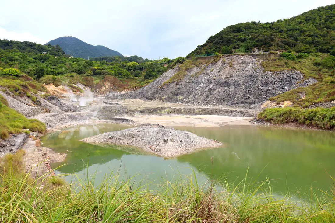
Sulfur Valley (Liuhuang Valley) in Yangmingshan National Park is a large volcanic sulfur hot spring area with hiking trails, steam vents, sulfur deposits, and large natural hot springs. Sulfur Valley contains a trail that circles the area, and also has a free public spring to soak your feet in. It is a unique and interesting stop on the mountain and worth a visit on your trip to Yangmingshan.
Background: The area known as Yangmingshan now was formed by volcanoes about 700,000 years ago, forming many mountains about 1000 meters or less in northwestern Taiwan. The park still features active volcanoes, vents, and hot springs. The original name of the area was Caoshan (grass mountain 草山). During the Qing Dynasty, the area was used to harvest sulfur, and many of the hills were burned to help catch sulfur thieves. In 1927 during the Japanese era, Yangmingshan was made as the first national park in Taiwan, then known as Datunshan National Park Association. In 1950 after the ROC took Taiwan Chiang Kai-shek renamed the park after the philosopher Wang Yangming, and called the area Yangmingshan. In 1985, after resolving many land disputes, Yangmingshan National Park was officially designated as a national park in the ROC era. The hot springs at Beitou were first converted into hot spring resorts in 1894, and Beitou become a popular hot spring location during the Japanese era, and there are many hot spring hotels and baths that exist there today. Sulfur Valley is also the source of some of the hot spring water for Beitou Hot Springs. Hours: 24/7 Activities: You can book a rock climbing experience at Sulphur Valley on Klook here or KKday here. Tours: You can check out tours to Yangmingshan such as a One-day Yangmingshan NP Beitou Hot Spring Park and Tamsui Tour Package, Beitou and Yangmingshan Day Tour from Taipei, One Day Hike around Yangmingshan, or Private Yangmingshan Volcano Tour and more on TripAdvisor here, Klook here, or KKday here. Hotels in Taipei: High end: We have stayed at and recommend the Yuanshan Grand Hotel, once the tallest building in Taiwan and still the most grand (book on Booking.com here, Tripadvisor here, or Agoda here). We also recommend Fullon Hotel which has locations in Tamsui and Fulong near the beach (book on Booking.com here, Tripadvisor here, Agoda here, or Hotels.com here). Budget Hotels: We have stayed at and also recommend Fu Chang Hotel in Ximending, which is within walking distance of Ximending shopping district (book on Booking.com here, Tripadvisor here, or Agoda here). We have also stayed at and recommend Hai Xia Your Home which is right in front of Fulong Beach (book on Booking.com here, Tripadvisor here, Agoda here, or Hotels.com here). Looking for a hotel? We recommend booking through Booking.com here, which provides the best quality selection of accommodation in Taiwan. Find out where to stay in our Taiwan hotels guide or search for the best hotel deals in Taiwan here. How to get there: By Bus: From near Xinbeitou MRT station, take the S9 or S26 bus up the mountain to Mito Temple (Sulfur Valley) bus stop. You can book tickets to travel to Taipei via inter-city bus on Klook here. By Car/Scooter: From downtown Beitou, drive up Quanyuan Road until you reach the Sulfur Valley Parking lot, you can park there or on the side of the road. Looking for scooter rental in Taipei? Check out Qeeq here, Klook here, or KKday here to search for options. You can also check out our scooter rental guide here. If you are looking for car rentals, you can also search Qeeq here, Klook here, or KKday here. You can also check out our car rental guide here. By Bicycle: Cycling is the best way to enjoy Taiwan's landscapes if you have the time and energy. Looking for bicycle rentals in Taiwan? You can use Taiwan's many Youbike sharing stations, or search for rentals on KKday here, and search for tours on Klook here. You can also check out our Taiwan cycling guide here. ​You can also book a Sunset Riverside Bike Ride and Historical Tour, 4 Hour Cycling in Taipei, Ultimate 8-Hour Cycling City Tour, or Taipei City Bike Tour with Night Market Experience on TripAdvisor here. Map: Please see below: 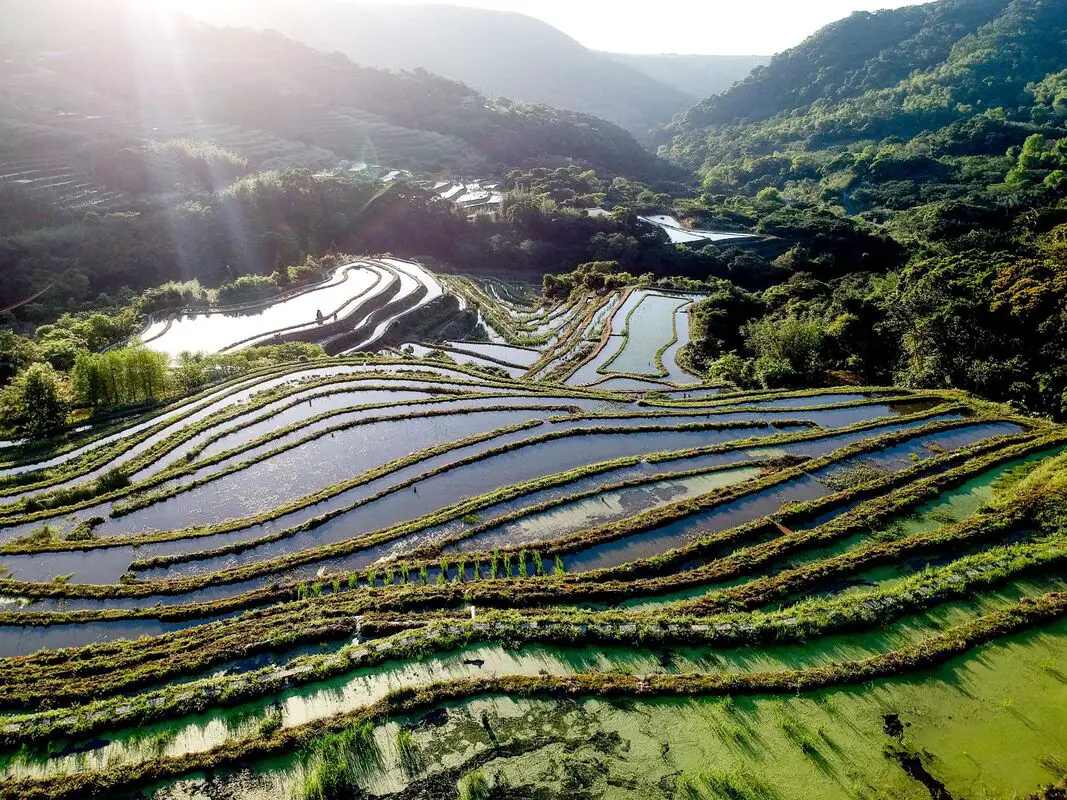
If you feel like leaving the country for some different scenery, you can instead head over to the Shimen Songshan terraced fields in New Taipei (aka 100 year stone terrace fields 百年石砌梯田)
near the border of Yangmingshan National Park. Here you can enjoy walking around the only stone terraced fields in the entire country. Background: The area known as Yangmingshan now was formed by volcanoes about 700,000 years ago, forming many mountains about 1000 meters or less in northwestern Taiwan. The park still features active volcanoes, vents, and hot springs. About 100 years ago, settlers came to cultivate the mountainous area here. They used the easily obtainable volcanic rocks and used them to build stone terraces in the hills in order to plant crops. This kind of terraced field in Taiwan can only be found here. Currently the most famous crop here is the Chrysanthemum Flower, which flowers about in mid-June. Hours: You can visit the fields here anytime, but the coffee shop here is only open on weekends until 4 PM. Price: Free You can book tours to Yangmingshan on TripAdvisor here, Klook here, or KKday here or here. Tours: You can check out tours to Yangmingshan such as a One-day Yangmingshan NP Beitou Hot Spring Park and Tamsui Tour Package, Beitou and Yangmingshan Day Tour from Taipei, One Day Hike around Yangmingshan, or Private Yangmingshan Volcano Tour and more on TripAdvisor here, Klook here, or KKday here. Hotels in Taipei: High end: We have stayed at and recommend the Yuanshan Grand Hotel, once the tallest building in Taiwan and still the most grand (book on Booking.com here, Tripadvisor here, or Agoda here). We have also stayed at and recommend the Grand Hyatt (book on Booking.com here, Tripadvisor here, Agoda here, or Hotels.com here), Marriot (book on Booking.com here, Tripadvisor here, Agoda here, or Hotels.com here), Sheraton (book on Booking.com here, Tripadvisor here, Agoda here, or Hotels.com here), Shangri-la (book on Booking.com here, Tripadvisor here, Agoda here, or Hotels.com here), and Regent (book on Booking.com here, Tripadvisor here, Agoda here, or Hotels.com here), which are all very high quality hotels in the middle of Taipei City. We also recommend Fullon Hotel which has locations in Tamsui and Fulong near the beach (book on Booking.com here, Tripadvisor here, Agoda here, or Hotels.com here). Budget Hotels: We have stayed at and also recommend Fu Chang Hotel in Ximending, which is within walking distance of Ximending shopping district (book on Booking.com here, Tripadvisor here, or Agoda here). We have also stayed at and recommend Hai Xia Your Home which is right in front of Fulong Beach (book on Booking.com here, Tripadvisor here, Agoda here, or Hotels.com here). Looking for a hotel? We recommend booking through Booking.com here, which provides the best quality selection of accommodation in Taiwan. Find out where to stay in our Taiwan hotels guide or search for the best hotel deals in Taiwan here. How to get there: By Car/Scooter: From Laomei Beach in Shimen, take highway 19-1 Laobengshan Road up the mountain until you reach the terraced fields, they are hard to miss. Looking for scooter rental in Taipei? Check out Qeeq here, Klook here, or KKday here to search for options. If you are looking for car rentals, you can also search Qeeq here, Klook here, or KKday here. You can also check out our car rental guide here. By Bus: You can take bus 867 which departs from Tamsui to Shuntian Shengmu Temple bus stop, and you are there! No more walking required. You can book tickets to travel to Taipei via inter-city bus on Klook here. You can book tickets to Taipei via high speed rail (HSR) on Klook here or KKDay here. By Bicycle: Cycling is the best way to enjoy Taiwan's landscapes if you have the time and energy. Looking for bicycle rentals in Taiwan? You can search on KKday here and search for tours on Klook here. You can also check out our Taiwan cycling guide here. Map: Please see below: 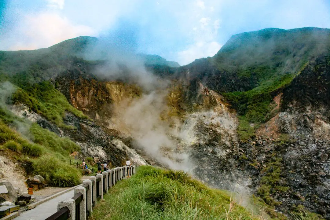
Xiaoyoukeng in Yangmingshan National Park is a large volcanic steam vent area with hiking trails, fumaroles, sulfur deposits, and natural hot springs. Even though the name means "small sulfur hole," it is perhaps the largest and most easily accessible volcanic steam vent area in Taiwan. One could say that it is the Yellowstone of Taiwan. It is a quiet a pleasant stop on the mountain and worth a visit on your trip to Yangmingshan.
Background: The area known as Yangmingshan now was formed by volcanoes about 700,000 years ago, forming many mountains about 1000 meters or less in northwestern Taiwan. The park still features active volcanoes, vents, and hot springs. The original name of the area was Caoshan (grass mountain 草山). During the Qing Dynasty, the area was used to harvest sulfur, and many of the hills were burned to help catch sulfur thieves. In 1927 during the Japanese era, Yangmingshan was made as the first national park in Taiwan, then known as Datunshan National Park Association. In 1950 after the ROC took Taiwan Chiang Kai-shek renamed the park after the philosopher Wang Yangming, and called the area Yangmingshan. In 1985, after resolving many land disputes, Yangmingshan National Park was officially designated as a national park in the ROC era. Xiaouyoukeng (literally "Small Oil Crater" gets its name because the there are two main sulfur vents on Yangmingshan, and it was thought to be the smaller one. The venting crater lies about 805 meters above sea level. A few kilometers under the ground, there is a leftover lava chamber from a previous eruption that heats up ground water and sends it spewing back to the surface. It is a popular stop in Yangmingshan and has two parking lots and visitor's center. It is also one of the starting points for the Mt. Qixing Trail. Hours: The visitor's center is open from 9 AM to 4:30 PM. Price: Free (parking 30 NT) You can book tours to Yangmingshan on TripAdvisor here, Klook here, or KKday here or here. Tours: You can check out tours to Yangmingshan such as a One-day Yangmingshan NP Beitou Hot Spring Park and Tamsui Tour Package, Beitou and Yangmingshan Day Tour from Taipei, One Day Hike around Yangmingshan, or Private Yangmingshan Volcano Tour and more on TripAdvisor here, Klook here, or KKday here. Hotels in Taipei: High end: We have stayed at and recommend the Yuanshan Grand Hotel, once the tallest building in Taiwan and still the most grand (book on Booking.com here, Tripadvisor here, or Agoda here). We also recommend Fullon Hotel which has locations in Tamsui and Fulong near the beach (book on Booking.com here, Tripadvisor here, Agoda here, or Hotels.com here). Budget Hotels: We have stayed at and also recommend Fu Chang Hotel in Ximending, which is within walking distance of Ximending shopping district (book on Booking.com here, Tripadvisor here, or Agoda here). We have also stayed at and recommend Hai Xia Your Home which is right in front of Fulong Beach (book on Booking.com here, Tripadvisor here, Agoda here, or Hotels.com here). Looking for a hotel? We recommend booking through Booking.com here, which provides the best quality selection of accommodation in Taiwan. Find out where to stay in our Taiwan hotels guide or search for the best hotel deals in Taiwan here. How to get there: By Car/Scooter: From Taipei, take provincial highway 2A north to the Zhizihu Lookout. Keep right until you reach the turnoff the the Xiaoyoukeng parking lot on the right. Car parking is limited on weekends and the number of cars allowed up the mountain is also limited. There is also paid scooter parking. Looking for scooter rental in Taipei? Check out Qeeq here, Klook here, or KKday here to search for options. If you are looking for car rentals, you can also search Qeeq here, Klook here, or KKday here. You can also check out our car rental guide here. By Bus: From Beitou MRT Station, Take Little Bus 9 (小9) to Xiaoyoukeng Station (小油坑). You can book tickets to travel to Taipei via inter-city bus on Klook here. By Bicycle: Cycling is the best way to enjoy Taiwan's landscapes if you have the time and energy. Looking for bicycle rentals in Taiwan? You can use Taiwan's many Youbike sharing stations, or search for rentals on KKday here, and search for tours on Klook here. You can also check out our Taiwan cycling guide here. You can also book a Sunset Riverside Bike Ride and Historical Tour, 4 Hour Cycling in Taipei, Ultimate 8-Hour Cycling City Tour, or Taipei City Bike Tour with Night Market Experience on TripAdvisor here. Map: Please see below: |
Author 作家I am an American expat who has extensive experience living, working, and traveling in Taiwan. In my day, I had to learn many things about Taiwan the hard way. But I have come to learn that Taiwan is one of the best places in the world for Foreigners to live. This blog does not represent the opinions of every foreigner in Taiwan. I am just trying to help others learn more about this beautiful country. Categories
|
 RSS Feed
