

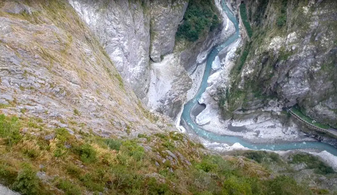
If you only have a few days in Taiwan and you want to go somewhere outside of Taipei, you should definitely go to Taroko National Park. On an island full of mountains, rain forests, beaches, and abounding natural beauty, Taroko might just take the top spot as the most beautiful scenic area in Taiwan.
Taroko National Park is well known for its amazing marble cliffs and canyons carved out by the Liwu River. It is also a popular spot for hiking, rafting, and river tracing. If you have the time, come to the East coast and see it. If you don't have time, then make some time! History and Background: Taroko National Park is well known for its marble cliffs and canyons, and is also known as "The Marble Gorge." Millions of years ago, the rock we see today was sediment at the bottom of the Pacific Ocean, but oceanic and tectonic pressure turned it into limestone, and later into marble. Later the Eurasian plate was uplifted where Taiwan is today, and a gorge was cut out of the limestone thanks to the Liwu River. Taroko means "human being," from the Truku tribal language. Originally the Tupido Tribe settled in the area of what is now Tianxiang Taiti mesa. They built the Tupido Tribe Trail which was only 30 cm wide, and resided there until they were massacred by the Japanese in 1914. In 1917, the Japanese expanded the original trail made by the Tupido Tribe to 1.5 M and forced aboriginal tribesmen to carry goods along the trail to the east coast. This is now the Zhuilu Old Trail. Currently only 3km of the trail is open to the public. The Japanese created a national park in the Area in 1937, which was disestablished by the ROC in 1945, and then reenstated in as a national park in 1986. When to visit? Hualien is great year round, but it can get a little hot in the summer, and Typhoon season and heavy rain season lasts from about May to October. If you are afraid of the heat and rain then you can visit during winter when the temperatures are mild and the climate is usually dryer. Sponsored Links Where to stay? Most of the accommodation you will find is near the city center. If you only want to visit Hualien City and Taroko Gorge, you can consider booking a hotel near downtown, walking or cycling around the city, and taking a bus to Taroko Gorge. We have stayed at and recommend Dream Taiwan Homestay (Agoda / Booking.com / Expedia / Hotels.com), a high quality hostel for the money in downtown Hualien, Farglory Hotel (Agoda / Booking.com / Expedia / Hotels.com), right next to Farglory Ocean Park with amazing views of Hualien, and Goldenflower B&B (Agoda / Booking.com) in Yuli right next to Sixty Stone Mountain. You can find out where to stay in our Taiwan hotels guide or search for the best hotel deals in Taiwan here. How to get there: By Car: From Taipei, Take National Highway 5 to Yilan and then drive on the Suhua Highway 9 to Hualien. A few miles before Hualien City, the gorge will be on your right. By Train: Take the train to Hualien station, and from there you can rent a scooter or car, or take a tour bus to the gorge. For more travel information see here. You can book tickets to travel to Hualien via inter-city bus on Klook here. Book tickets via the normal train (TRA) on Klook here. Need travel insurance? Compare prices on Insubuy here. How to get around in Taroko Gorge: As always, we recommend renting a scooter as the best way to see Taiwan. However, you can also a great deal of Tainan by taking the train, inter-city bus, local bus, biking, or just walking. Getting around in a car is also a convenient option as there is plenty of parking pretty much everywhere in this less crowded county. By Bus: You can book a shuttle bus to Taroko Gorge from Hualien on Klook here. Scooter Rental: Looking for scooter rental in Hualien? You can search KKday here or Klook here to look for options. You can also check out our scooter rental guide here. Car Rental: If you are looking for car rentals in Hualien, you can also search Klook here or KKDay here. You can also check out our car rental guide here. Tours: You can find more tours and activities in Hualien such as Surfing, Paragliding, SUP / Paddle Boarding, Kayaking, Canoeing, River Tracing, River Rafting, Whale Watching, Snorkeling, Diving, ATV / 4-wheeling, Paintballing, Farm Dream Estates Zoo, Water Biking, Oyster Harvesting, Shrimp Harvesting, Indigenous Experience, Glamping, Cycling, Ziplining and much more on Klook here or KKday here. You can also book Wifi and SIM cards for Taiwan on Gigago here. Just to let you know, if you book using the links above, we get some commission at no cost to you, and you can help support our blog. You can click here to receive $5 USD on your first Klook purchase. Hours: 8:30AM-5PM (Zhuilu old trail is open from 7AM to 10PM). Flying a Drone? Apply for a drone permit here. Price: Free! (Except Zhuilu old trail, which is 200 NT per adult. See below for more info.) Map: Please see below:
0 Comments
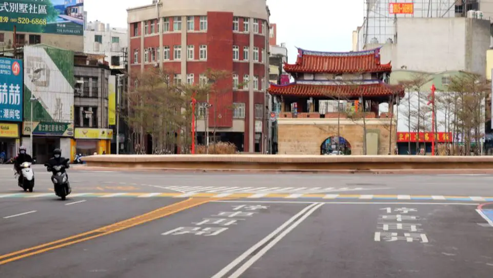
Hsinchu is not only Taiwan's technological hub, but is also rich with historical sights, Hakka culture, and natural beauty. It has numerous old streets, preserved Japanese-era and Qing-era buildings, zoos, mountains, lakes, rivers, beaches, and much more to explore. It is definitely worth a stop on your next trip to Taiwan.
History of Hsinchu: After the settlement of the area by Han Chinese farmers in about 1711, what was then known as Zhuqianshe became the most important economic area in northern Taiwan. By 1723, a walled city was built here out of bamboo, because brick walls were forbidden for fear of a revolt against the Qing authorities. The name Zhuqiancheng (竹塹城) literally means bamboo moat city. The bamboo-walled city had four gates and its perimeter was about 1.4 KM long. In 1806, the city was upgraded with earthen walls. In 1828, the city walls and gates were finally made into brick, with the perimeter covering 2.7 KM, and walls 5 meters high, the center of the city being the Chenghuang City God Temple. In 1901, the Japanese government decided to redesign the City of Hsinchu and destroyed all the gates and walls except the existing East Gate. In the ROC era, the Hsinchu Science Park was established in 1980 under President Chiang Jingkuo, and was made to model silicon valley. TSMC, Taiwan's most important corporation, was formed in 1987 with its headquarters in the park and created a technological hub, making Hsinchu indispensable to Taiwan's economy. When to visit: It is best to visit from April to November when the weather is warm and less windy. There is a constant, cold northeasterly wind from December to March especially along the coast. However, the winter in general is more dry. Where to stay: Most of the accommodation you will find is near the city center. If you will only visit downtown, you can consider a day trip from Taipei. We have stayed at and recommend the Golden Motel a high quality motel near Green Grass Lake (you can book on Agoda here, Booking.com here, Hotels.com here, Expedia here, or Trip.com here), and CD Motel, another high quality motel in downtown Hsinchu (you can book on Agoda here, Booking.com here, or Trip.com here). Unfortunately I cannot recommend any further hotels that I have stayed at in Hsinchu because usually we stay at my wife's uncle's house. You can find out where to stay in our Taiwan hotels guide or search for the best hotel deals in Taiwan here. You can also book Wifi and SIM cards for Taiwan on Gigago here. Need travel insurance? Compare prices on Insubuy here. How get to Hsinchu? You can book tickets to travel to Hsinchu via inter-city bus on Klook here. You can book tickets to Hsinchu via high speed rail (HSR) on Klook here or KKDay here. Book tickets via the normal train (TRA) on Klook here. How to get around in Hsinchu: As always, we recommend renting a scooter as the best way to see Taiwan. However, you can also a great deal of Hsinchu by taking the train, inter-city bus, or local bus. Getting around in a car is also a convenient option as there is plenty of parking pretty much everywhere in this less crowded county. Scooter Rental: Looking for scooter rental in Hsinchu? You can search Klook here or KKday here to look for options. You can also check out our scooter rental guide here. Car Rental: If you are looking for car rentals in Hsinchu, you can also search Qeeq here, Klook here, or KKDay here. You can also check out our car rental guide here. By Bicycle: Cycling is the best way to enjoy Taiwan's landscapes if you have the time and energy. Looking for bicycle rentals in Taiwan? You can search on KKday here and Klook here. You can also check out our Taiwan cycling guide here. Tours: You can find more tours and activities in Hsinchu such as You can find more tours and activities in Hsinchu such as river tracing, wild hot springs, white water kayaking, backpack rafting, Little Ding Dong Theme Park, Leofoo Village Theme Park, Window on China Theme Park, glamping, camping, stone spa, horse riding, Yukids Island, Tom and Bei Bei Parent Child Paradise, bee keeping experience, cycling, dried persimmons experience, Jump Wave Trampoline Park and more on Klook here or KKday here. Just to let you know, if you book using the links above, we get some commission at no cost to you, and you can help support our blog. You can click here to receive $5 USD on your first Klook purchase. Map: See below for a map of places we will cover in this blog: 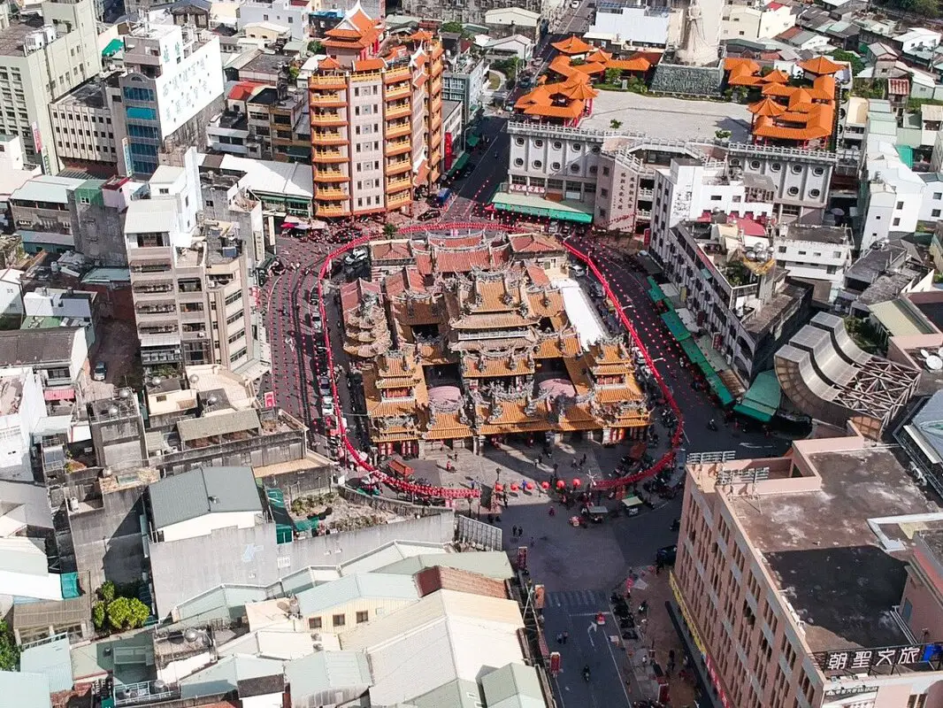
Yunlin is a rural county in western Taiwan that for many expats is simply a large landmass on their way to another destination. However, there are many worthwhile places to visit here, such as interesting historical sites, natural beauty, and rich culture worth exploring.
Below I will list some of the best places in Yunlin that I have visited. I will be sure to update this blog as I visit more places later. Historical Background:
Before Han Chinese settlement, Yunlin was inhabited by native peoples. During the Dutch era in Taiwan in the 1600s, Chinese farmers first began to move here. One notable Chinese pioneer was Yan Siqi (also known as Pedro Chino, or the Pioneer King of Taiwan). He created a settlement in Ponkan (modern day Beigang, Yunlin) and recruited over 3000 farmers from Fujian and nearby regions in China to come farm in Taiwan. He also had 13 ships and a merchant trade and formed an alliance with the local indigenous population.
Dutch and Chinese farmers introduced mango, sweet potato, pineapple, and many other crops to Taiwan at this time. During the Qing Dynasty, Yunlin became its own county under governor Liu Mingchuan. The most economically important town, Douliu, continued to be the center of commerce in the Japanese era, and the area was combined with Tainan County. In 1950 Yunlin became its own county again, and Douliu was upgraded to a city. Douliu is unique because it is the largest city in Yunlin, but is not named after Yunlin County like all the other largest cities in each county (there is no Yunlin City). Currently, Yunlin's economy is mainly composed of agriculture and fishing. The population of Yunlin County is about 650,000 and continues to drop every year due to emigration, with young people moving to bigger cities for work opportunities. In addition, the area is underdeveloped compared with other places in Taiwan. How to get around in Yunlin?
As always, we recommend renting a scooter as the best way to see Taiwan. However, you can also a great deal of Yunlin by taking the train, inter-city bus, or local bus (there is no MRT in Yunlin). Getting around in a car is also a convenient option as there is plenty of parking pretty much everywhere in this less crowded county.
By Scooter:
Looking for scooter rental in Yunlin? Check out Klook here or KKday here to search for options. You can also check out our scooter rental guide here.
By Car:
If you are looking for car rentals, you can also search Qeeq here, Klook here, or KKday here. You can also check out our car rental guide here.
By Bus/Train:
You can book tickets to travel to Yunlin via inter-city bus on Klook here.
You can book tickets to Yunlin via high speed rail (HSR) on Klook here or KKDay here. Book tickets via the normal train (TRA) on Klook here. By Bicycle:
Cycling is the best way to enjoy Taiwan's landscapes if you have the time and energy. Looking for bicycle rentals in Taiwan? You can search on KKday here and search for tours on Klook here. You can also check out our Taiwan cycling guide here.
Basic Yunlin Travel Tips:
When should you go to Yunlin?
In my opinion, the best weather in Taoyuan is from October - March, when the temperatures stay around 26 degrees Celsius and there is not as much rain.
Summers are also nice, with the most sunny weather, but also hot and rainy. Winters can be cold and windy but usually dry. Overall, there is no wrong answer as to what time of year you should visit Yunlin. You will have a great time here at any time of year. Where to stay:
We have stayed at and recommend Ai Ni Ya Hotel, with great quality and service right in downtown Beigang (book on Agoda here or Booking.com here).
We also recommend the Grand Earl Hotel, a high class hotel in central Douliu (book on Agoda here or Booking.com here) Looking for a hotel? We recommend booking through Agoda here, which provides the best quality selection of accommodation on the islands. Find out where to stay in our Taiwan hotels guide or search for the best hotel deals in Taiwan here. Tours in Yunlin:
Tours and activities in Yunlin include Janfusun Fancy World Amusement Park, Kite Surfing, Tree Climbing , Chaoyang Green Energy Farm, Sam Siu Garden, Pink Castle Park, Gukeng Green Tunnel, Caoling Highway, and more.
You can find more tours of Yunlin on Klook here or KKday here. Yunlin Tourist Sites Map:
You can see a map of all the places that we will visit in this blog below:

Jiaobanshan is a scenic area in the mountainous Fuxing District of Taoyuan. Here you can enjoy majestic views of Xikou Suspension Bridge and the Dahan River. You can also enjoy a local shopping area and the aboriginal culture of the area nearby.
Brief Historical Background: Fuxing District is the largest district in Taoyuan City, and also the least populous (13,000) and is home to the Ayatal aboriginal tribe who have inhabited the area for centuries. They named the area Pyasan, meaning a trading post. The area was named Jiaobanshan during the Qing Dynasty by Liu Mingchuan because the area resembled triangular shapes, shaped by the Dahan River. In 1954, the area was renamed Fuxing (meaning rejuvenation) District by Chiang Kai-shek as a token of the rejuvenation of the nation. The area is known for its aboriginal culture and as a recreational mountain area, especially for such places as Xiaowulai and Lalashan. Hours: 24/7 Price: Free Where to stay: Looking for a hotel in Taoyuan? We recommend the Novotel Taipei Taoyuan International Airport which has great service and is conveniently located right next to Taoyuan Airport, the MRT, and HSR station (you can book on Agoda here or Booking.com here). We also recommend the Fullon Hotel Taoyuan which also has great service and is located in downtown Taoyuan City (you can book on Agoda here or Booking.com here). Looking for a hotel? We recommend booking through Booking.com here, which provides the best quality selection of accommodation in Taiwan. Find out where to stay in our Taiwan hotels guide or search for the best hotel deals in Taiwan here. Activities in Taoyuan: Ice Skating, Rock Climbing, Mountain Climbing, Cycling, High Ropes, Ziplining, Archery, Vietnamese BBQ, Batting Cages, Glamping, Van Camping, Photo Shoot, Turkish Mosaic DIY, Thai Massage, Painting, Baking, Go Karting, Imax Theater, Japanese Style Buffet, Tourist Factory Experience, peach and fruit picking, Ring-making DIY, handmade popsicle DIY, and more on on Tripadvisor here, Klook here, or KKday here. How to get there: By Car: Take Provincial Highway 7 east up Fuxing District until you get near Jiaobanshan and turn right onto Ren'ai Road. There is limited parking nearby. If you are looking for car rentals, you can also search Qeeq here, Klook here, or KKday here. By Scooter: Take Provincial Highway 7 east up Fuxing District until you get near Jiaobanshan and turn right onto Ren'ai Road. There is limited parking nearby. Looking for scooter rental in Taoyuan? Search Klook here or KKday here to look for options. By Bus: You can take many different busses to Taoyuan Bus Fuxing Station. You can book tickets to travel to Taoyuan via inter-city bus on Klook here. Book tickets via the normal train (TRA) on Klook here. By Bicycle: Cycling is the best way to enjoy Taiwan's landscapes if you have the time and energy. Looking for bicycle rentals in Taiwan? You can use Taiwan's many Youbike sharing stations, or search for rentals on KKday here, and search for tours on Klook here. You can also check out our Taiwan cycling guide here. You can also book a cycling tour on TripAdvisor here. For more information, check out our Taiwan transportation guide here. Map: Check out the map below: 
Longtan Lake is a beautiful scenic lake in the middle of Longtan District of Taoyuan. Here you can find majestic scenery, stroll across five bridges around the lake, enjoy local cuisine, and marvel at the Longtan temple which sits on an island in the middle of the lake. It is also the location of boat races during the Dragon Boast Festival. It is a great place to spend an afternoon with the whole family.
Brief Historical Background: Longtan Lake is man made, and was created for irrigation purposes in 1748 by local leader Zhimuliu. During the Qing Dynasty, the lake was called Lingtanpi in honor of the local temple at the time, but was changed to Longtan during the Japanese era likely as a mistake since the name sounds the same in Taiwanese. The Lake spans 18 Hectares and is about half a meter deep. After the construction of the suspension bridge in 1971 and Nantian Temple in 1972 on a man made island in the lake, the lake soon became a major tourist attraction in the area. In the summer, a child's splash pool opens on the southern side of the lake. There are also bike paths, a children's playground, walking trails, a music memorial hall, and paddle boat rentals. The area Hours: 24/7 Longtan Dragon Boat Races: June 8th-10th 2024 Check out our full guide to Taiwan's dragon boat festival here. Price: Free Where to stay: Looking for a hotel in Taoyuan? We recommend the Novotel Taipei Taoyuan International Airport which has great service and is conveniently located right next to Taoyuan Airport, the MRT, and HSR station (you can book on Agoda here or Booking.com here). We also recommend the Fullon Hotel Taoyuan which also has great service and is located in downtown Taoyuan City (you can book on Agoda here or Booking.com here). Looking for a hotel? We recommend booking through Booking.com here, which provides the best quality selection of accommodation in Taiwan. Find out where to stay in our Taiwan hotels guide or search for the best hotel deals in Taiwan here. Activities in Taoyuan: Ice Skating, Rock Climbing, Mountain Climbing, Cycling, High Ropes, Ziplining, Archery, Vietnamese BBQ, Batting Cages, Glamping, Van Camping, Photo Shoot, Turkish Mosaic DIY, Thai Massage, Painting, Baking, Go Karting, Imax Theater, Japanese Style Buffet, Tourist Factory Experience, peach and fruit picking, Ring-making DIY, handmade popsicle DIY, and more on on Tripadvisor here, Klook here, or KKday here. How to get there: By Car: Take National Freeway 3 to Longtan. The pond is near the city center. There is limited paid parking near Nantian Temple and also other paid parking nearby. If you are looking for car rentals, you can also search Qeeq here, Klook here, or KKday here. By Scooter: Take Provincial Highway 3 to Longtan, then continue southwest until you reach the lake. Looking for scooter rental in Taoyuan? Search Klook here or KKday here to look for options. By Bus: There are many buses that leave from Zhongli TRA station to Longtan. The ride takes about an hour. You can also take an inter-city bus from Taipei Main Station. You can book tickets to travel to Taoyuan via inter-city bus on Klook here. Book tickets via the normal train (TRA) on Klook here. By Bicycle: Cycling is the best way to enjoy Taiwan's landscapes if you have the time and energy. Looking for bicycle rentals in Taiwan? You can use Taiwan's many Youbike sharing stations, or search for rentals on KKday here, and search for tours on Klook here. You can also check out our Taiwan cycling guide here. You can also book a cycling tour on TripAdvisor here. For more information, check out our Taiwan transportation guide here. Map: Check out the map below: 
Huwei Iron Bridge, also known as Huwei Sugar Factory Bridge, is an old railway bridge dating back to the Japanese rule of Taiwan in 1907. The bridge is nearly half a kilometer long and is now part of the Huwei Sugar Factory Riverside Park. Popular activities here include cycling, jogging, and taking selfies. It is a great place to enjoy the history and beauty of the local area.
Historical Background: Huwei Sugar Factory was built in 1906 before Huwei Town existed. The town began to develop on the outskirts of the sugar factory as employees began to settle nearby. The sugar factory is still operating and processing sugar. There is also a Taisugar ice cream shop that operates nearby. The Huwei Sugar Factory Bridge was originally a wooden bridge built during the Japanese era to facilitate the transportation of sugarcane to the Huwei Sugar Factory and was constructed in 1907. Besides transporting sugarcane, it also acted as a passenger train. In 1931, the new iron bridge was constructed downstream from the original wooden bridge with a length of about 300.6 meters. In 1960, the Huwei Iron Bridge was extended to 437 meters. The bridge's northernmost steel truss is actually a 200-foot steel beam recycled from the Qing Dynasty railway in the Hsinchu area, dating back to the late 1800s. The bridge has a total of 21 piers, 22 bridge spans. The structure of this bridge consists of four different sections erected according to different span requirements due to changes in river terrain, forming step-like structure. The manufacturers of the bridge trusses or girders are known to include Westwood Baillie & Co. from England (2nd bridge span) and the Osaka Automobile Manufacturing Co., Ltd. from Japan (7th bridge span, manufactured in 1913). Huwei Sugar Factory was established in 1906, after which the local economy gradually developed and prospered, and the population increased. To solve transportation problems, the sugar company and the Railway Department of the Taiwan Governor's Office jointly operated a passenger railway between Dounan and Huwei in 1910, and the train also connected with the Western Main Line. In 1942, the bridge was damaged in a storm but was later repaired. During the ROC era in 1954, a wooden pedestrian bridge was built on the right side of the iron bridge, creating a safe passage for pedestrians. In 1959, the 87 Flood occurred, and the south bank of the river was breached, causing the bridge to be destroyed. Afterward, the riverbed was widened and the riverbanks were reinforced to prevent erosion. In June 1960 the bridge was extended by about 185 meters solving local flooding problems. In 1982, the construction of the Xingnan Bridge gradually replaced the function of the wooden plank bridge beside the iron bridge. After that, it remained idle for a long time and was not well maintained. The reconstruction project of the Huwei Iron Bridge was completed in 1999, and it was named the Sweet Potato Village Plank Bridge. Subsequently, both sides of the bridge were converted into a "riverside park," combining the nearby Huwei Sugar Factory and Tongxin Park, to provide an ideal place for sightseeing and leisure for the public. In 2012, during Typhoon Saola, about 50 meters of the bridge deck was washed away by floodwaters. The restoration of the Huwei Bridge was completed on September 9, 2015. Currently, the bridge is a popular place for local residents especially on weekends. Hours: Huwei Iron Bridge: 24/7 Price: Free Where to stay: We have stayed at and recommend Ai Ni Ya Hotel, with great quality and service right in downtown Beigang (book on Agoda here or Booking.com here). We also recommend the Grand Earl Hotel, a high class hotel in central Douliu (book on Agoda here or Booking.com here) Looking for a hotel? We recommend booking through Agoda here, which provides the best quality selection of accommodation on the islands. Find out where to stay in our Taiwan hotels guide or search for the best hotel deals in Taiwan here. Tours in Yunlin: Tours and activities in Yunlin include Janfusun Fancy World Amusement Park, Kite Surfing, Tree Climbing , Chaoyang Green Energy Farm, Sam Siu Garden, Pink Castle Park, Gukeng Green Tunnel, Caoling Highway, and more. You can find more tours of Yunlin on Klook here or KKday here. Just to let you know, if you book using the links above, we get some commission at no cost to you, and you can help support our blog. You can click here to receive $5 USD on your first Klook purchase. How to get there: By Scooter: From Provincial Highway 1, go east to Dounan and then take Highway 158 to Huwei. There is free parking on the side of the road. Looking for scooter rental in Yunlin? Check out Klook here or KKday here to search for options. You can also check out our scooter rental guide here. By Car: From National Freeway 1, get off at the Huwei Exit and keep going east until you reach Huwei Town. The bridge is on the south side of town along Highway 73-3 and is hard to miss. There is free parking on the side of the road. If you are looking for car rentals, you can also search Qeeq here, Klook here, or KKday here. You can also check out our car rental guide here. By Bus/Train: From Yunlin HSR Station, you can take bus 7112 for about 30 minutes to Huwei Puppet Museum. The bridge is then about a 10 minute walk south. You can also book tickets to travel to Yunlin via inter-city bus on Klook here. You can book tickets to Yunlin via high speed rail (HSR) on Klook here or KKDay here. Book tickets via the normal train (TRA) on Klook here. By Bicycle: Cycling is the best way to enjoy Taiwan's landscapes if you have the time and energy. Looking for bicycle rentals in Taiwan? You can search on KKday here and search for tours on Klook here. You can also check out our Taiwan cycling guide here. Map: Please see below: 
Beigang Iron Bridge is the longest bridge ever built by the Taiwan Sugar Company, that used to connect sugar fields in Chiayi to the Beigang Sugar Factory. Unfortunately, the bridge was washed away in floodwaters during Typhoon Sinlaku in 2008.
Currently a new "Daughter Bridge" has been completed to connect the two sides, and further construction is expected to connect the two sides of the river via pedestrian walkways by 2025. Historical Background: Before Han Chinese settlement, Yunlin was inhabited by native peoples. During the Dutch era in Taiwan in the 1600s, Chinese farmers first began to move here. One notable Chinese pioneer was Yan Siqi (also known as Pedro Chino, or the Pioneer King of Taiwan). He created a settlement in Ponkan or Bengang in Mandarin (modern day Beigang) and recruited over 3000 farmers from Fujian and nearby regions in China to come farm in Taiwan. He also had 13 ships and a merchant trade and formed an alliance with the local indigenous population. Dutch and Chinese farmers introduced mango, sweet potato, pineapple, and many other crops to Taiwan at this time. When Koxinga invaded Taiwan, many local Chinese farmers such as Chen Lixun supported him and were rewarded with lands once the Dutch were conquered. During the Qing Dynasty, Beigang was known as Bengang (笨港), and its waterways were made deeper than other areas in Taiwan, allowing for larger ships and more trade. Beigang soon became one of the most prosperous areas in central Taiwan. After many Typhoons and floods, the Beigang River became silted and shallow, and also due to silting Beigang was moved further and further from the seashore. Up to the Japanese colonial period, the port lost its function as a maritime trading location, but it remained a center for agricultural commerce. The establishment of sugar mills during the Japanese colonial period also brought significant economic benefits to Beigang for nearly a hundred years. However, since the Japanese colonial period, due to the silting of the port, the lack of a main railway line passing through, and the absence of a major highway, its economic influence has diminished significantly. Beigang Creek Iron Bridge The Beigang River Iron Bridge, also known as the Fuxing Bridge or Fuxing Iron Bridge, was built during the Japanese colonial period in Taiwan and later rebuilt and extended during the ROC era. It is located over the Beigang River at the border of Beigang Town in Yunlin County and Xingang Township. Currently, it is abandoned and partially destroyed due to flooding. During the Japanese Era, the Beigang River Bridge was originally a wooden structure built to facilitate the transportation of sugarcane to the Beigang Sugar Factory during the Japanese colonial period. Construction began in 1909 by the Beigang Sugar Manufacturing Society for the Beigang Line of the sugar industry railway between Beigang and Chiayi, which was completed and opened on August 30, 1911, along with the wooden Beigang River Bridge, spanning a length of 220 meters. In 1917, passenger services started operating. In 1943, the wooden Beigang Creek Bridge between Beigang and Wan Zai Nei was washed away by flooding, causing a train passing at that time to derail into the creek, resulting in dozens of casualties, making it the deadliest accident in the history of sugar railway passenger services. During the ROC Era after World War II in 1945, due to strong public demand, the Beigang River Bridge was repaired in 1951 and named the "Fuxing Iron Bridge." The Beigang Creek Iron Bridge had a total of 76 bridge piers, including 74 reinforced concrete girder piers. The upper structure of the bridge consisted of 74 composite steel beams and 2 lower-bearing steel plate girder beams. Train services resumed to Beigang. In 1967, the Beigang River was dredged, and embankments were built on the east bank of the iron bridge. Because of this, in 1968, the Taiwan Sugar Company raised and extended the Beigang Creek Iron Bridge by about 600 meters. The project was completed in June 1969, extending the total length of the bridge to 878 meters, making it the longest bridge used by the Taiwan Sugar Railway. On August 17, 1982, passenger services on the Beigang Line ceased, and the Beigang River Iron Bridge remained only for transporting raw materials. In 1998, Taiwan Sugar Factory completely ceased railway transportation in the area and the Beigang Line was discontinued. After the Beigang River Iron Bridge was decommissioned, Taiwan Sugar planned to demolish it in May 2000. Fortunately, it was saved due to the efforts of local activists. The bridge was made a historical site in 2001. Unfortunately, on September 12, 2002, several bridge piers at the north end of the bridge's water area were washed away by flooding, leading to its closure. Although efforts were made to repair it, the bridge suffered damage from flooding again during Typhoon Sinlaku in 2008. In 2021, The "Daughter Bridge" was finished alongside the old Fuxing Bridge to connect the two sides via pedestrian walkways. However, the Daughter Bridge was not finished and connected at the time of writing. In 2022, the central government approved a budget of 180 million yuan to support the reconstruction and repair project of the Beigang Iron Bridge on the Xingang, Chiayi side. Construction started on May 9, 2023, and is expected to be completed by late 2024 or early 2025 to complete the connection between the two sides. Hours: 24/7 Price: Free Where to stay: We have stayed at and recommend Ai Ni Ya Hotel, with great quality and service right in downtown Beigang (book on Agoda here or Booking.com here). We also recommend the Grand Earl Hotel, a high class hotel in central Douliu (book on Agoda here or Booking.com here) Looking for a hotel? We recommend booking through Agoda here, which provides the best quality selection of accommodation on the islands. Find out where to stay in our Taiwan hotels guide or search for the best hotel deals in Taiwan here. Tours in Yunlin: Tours and activities in Yunlin include Janfusun Fancy World Amusement Park, Kite Surfing, Tree Climbing , Chaoyang Green Energy Farm, Sam Siu Garden, Pink Castle Park, Gukeng Green Tunnel, Caoling Highway, and more. You can find more tours of Yunlin on Klook here or KKday here. How to get there: By Scooter: From Chiayi, go east on Highway 164 until you reach Beigang. The bridge is on the east side of town. There is free parking on the side of the road. Looking for scooter rental in Yunlin? Check out Klook here or KKday here to search for options. You can also check out our scooter rental guide here. By Car: From National Freeway 1, get off at the no. 257 Xingang / Minxiong Exit and keep going east on Highway 164 until you Reach Beigang. The bridge is on the east side of town. There is paid parking near the riverside at the end of the old street. If you are looking for car rentals, you can also search Qeeq here, Klook here, or KKday here. You can also check out our car rental guide here. By Bus/Train: From Chiayi HSR Station, you can take bus 7235 for about 40 minutes to Beigang Town. You can also book tickets to travel to Yunlin via inter-city bus on Klook here. You can book tickets to Yunlin via high speed rail (HSR) on Klook here or KKDay here. Book tickets via the normal train (TRA) on Klook here. By Bicycle: Cycling is the best way to enjoy Taiwan's landscapes if you have the time and energy. Looking for bicycle rentals in Taiwan? You can search on KKday here and search for tours on Klook here. You can also check out our Taiwan cycling guide here. Map: Please see below: 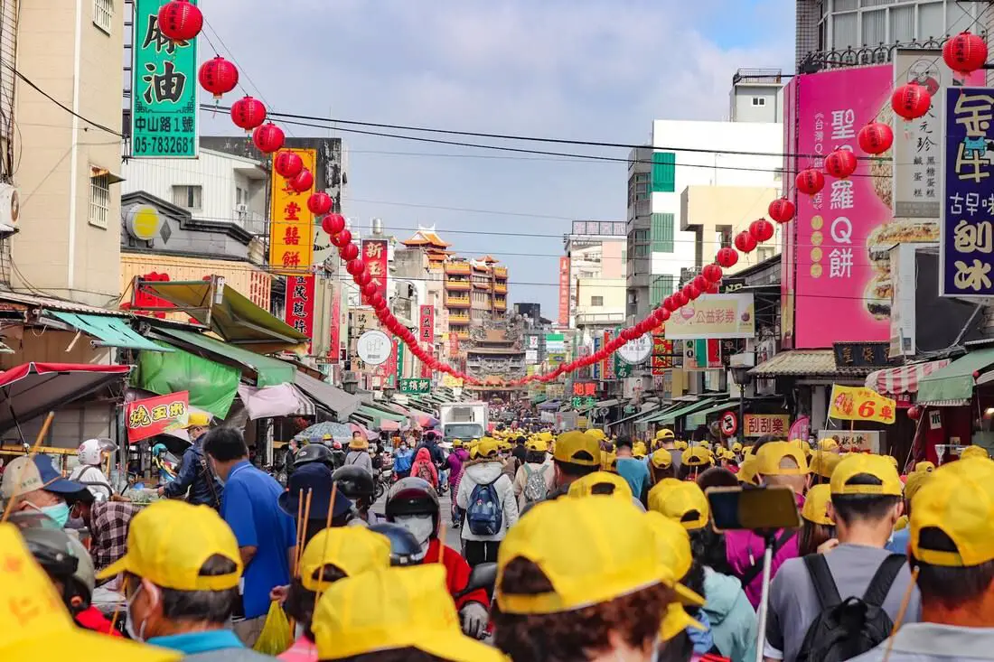
Beigang was once the second largest city in Taiwan, second only to Tainan City, and was central Taiwan's most important maritime trading post. After the silting of the Beigang River, the town mostly relies on agriculture for its economy, but Beigang Old Street is also one of the most important religious sites in Taiwan due to the worship of Mazu in Beigang Chaotian Temple. Besides the temple, there are also many food and shopping options nearby. It is definitely worth a stop on your next trip to central Taiwan.
Historical Background: Before Chinese settlers came to the area, Yunlin was inhabited by native peoples. During the Dutch era in Taiwan in the 1600s, Chinese farmers first began to move here. One notable Chinese pioneer was Yan Siqi (also known as Pedro Chino, or the Pioneer King of Taiwan). He created a settlement in Ponkan (笨港 Bengang, modern day Beigang) and recruited over 3000 farmers from Fujian and nearby regions in China to come farm in Taiwan. He also had 13 ships and a merchant trade and formed an alliance with the local indigenous population. Dutch and Chinese farmers introduced mango, sweet potato, pineapple, and many other crops to Taiwan at this time. When Koxinga invaded Taiwan, many local Chinese farmers such as Chen Lixun supported Koxinga and were rewarded with lands once the Dutch were conquered. During the Qing Dynasty, the waterways around the Beigang River were made deeper than other areas in central Taiwan, allowing for larger ships and more trade. Beigang soon became one of the most prosperous areas in central Taiwan. In 1700 Chen Lixun donated to build the "Penkan Tianfei Temple," now the "Beigang Chaotian Temple 北港朝天宮." The temple housed a statue of Mazu brought from Meizhou in Fujian. Soon, it became the most important temple in the area. The temple has undergone reconstruction in 1730, 1770, and 1884. Currently the temple sees more than a million visitors a year and is considered one of the most important Mazu temples in Taiwan, and is part of the annual Mazu pilgrimage. After many Typhoons and floods, the Beigang River became silted and shallow, and also due to silting the seashore moved further and further westward away from the town. In 1750, due to the southward shift of the river channel, Beigang Old Street was divided into two: North Street (now Beigang Town) and South Street (now Xingang Township, Chiayi County). Up to the Japanese colonial period, the port lost its function as a maritime trading location, but it remained a center for agricultural commerce. The establishment of sugar mills during the Japanese colonial period also brought significant economic benefits to Beigang for nearly a hundred years. The construction of Chaotian Temple and the widespread belief in Mazu further contributed to Beigang's fame. However, since the Japanese colonial period, due to the silting of the port, the lack of a main railway line passing through, and the absence of a major highway, its economic influence has diminished significantly. Currently the population of Beigang is about 38,000 and it continues to fall every year. Beigang Old Street is usually still busy especially on weekends due to religious pilmagriges. The street is especially busy during the Dajia Mazu pilgrimage. Hours: 24/7 Price: Free Where to stay: We have stayed at and recommend Ai Ni Ya Hotel, with great quality and service right in downtown Beigang (book on Agoda here or Booking.com here). We also recommend the Grand Earl Hotel, a high class hotel in central Douliu (book on Agoda here or Booking.com here) Looking for a hotel? We recommend booking through Agoda here, which provides the best quality selection of accommodation on the islands. Find out where to stay in our Taiwan hotels guide or search for the best hotel deals in Taiwan here. Tours in Yunlin: Tours and activities in Yunlin include Janfusun Fancy World Amusement Park, Kite Surfing, Tree Climbing , Chaoyang Green Energy Farm, Sam Siu Garden, Pink Castle Park, Gukeng Green Tunnel, Caoling Highway, and more. You can find more tours of Yunlin on Klook here or KKday here. Just to let you know, if you book using the links above, we get some commission at no cost to you, and you can help support our blog. You can click here to receive $5 USD on your first Klook purchase. How to get there: By Scooter: From Chiayi, go east on highway 164 until you Reach Beigang. There is free parking on the side of the road. Looking for scooter rental in Yunlin? Check out Klook here or KKday here to search for options. You can also check out our scooter rental guide here. By Car: From National Freeway 1, get off at the no. 257 Xingang / Minxiong Exit and keep going east on highway 164 until you Reach Beigang. There is paid parking near the riverside at the end of the old street. If you are looking for car rentals, you can also search Qeeq here, Klook here, or KKday here. You can also check out our car rental guide here. By Bus/Train: From Chiayi HSR Station, you can take bus 7235 for about 40 minutes to Beigang Town. You can also book tickets to travel to Yunlin via inter-city bus on Klook here. You can book tickets to Yunlin via high speed rail (HSR) on Klook here or KKDay here. Book tickets via the normal train (TRA) on Klook here. By Bicycle: Cycling is the best way to enjoy Taiwan's landscapes if you have the time and energy. Looking for bicycle rentals in Taiwan? You can search on KKday here and search for tours on Klook here. You can also check out our Taiwan cycling guide here. Map: Please see below: 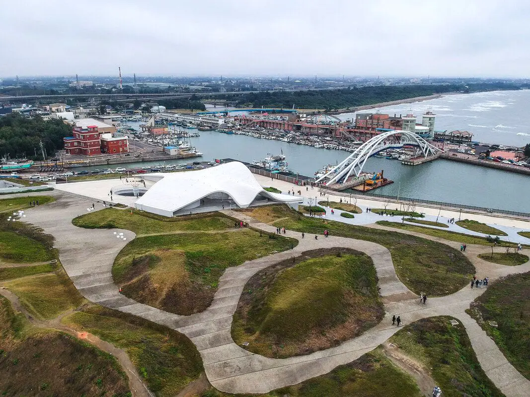
Yongan Fishing Harbor in Xinwu Township of Taoyuan is popular for its tourist seafood market, beautiful pedestrian bridge, as well as the newly created Yongan Conch Cultural Park (永安海螺文化體驗園區), which is a cultural and artistic center for the area. There are also great seaside bike paths nearby. Here you can enjoy the landscape, shop for freshly caught seafood, and also understand more about Hakka culture and the history of fishing in Taiwan. It is one of the most popular tourist destinations in Taoyuan.
Historical Background: Yong-an Fishing Harbor was established in 1953 and is a secondary class port. Before that it was known as Kaotouwu Port (崁頭屋港) which dates back to the 1800s during the Qing Dynasty, located on the north side of the mouth of the Shezi River. Originally a small fishing port, Yong-an Fishing Port has expanded over the years, including dredging channels and extending to allow for larger fishing vessels. The current port is 27,600 square meters, with room for approximately 450 vessels in total. Now there are about 99 small fishing vessels that dock in the harbor. The main catches here are mackerel, squid, black scraper, bonito, shark, and yellowtail fish. "Yong-an Sea-view Bridge 永安觀海橋" was completed in 2002 and is 110 meters long and 20 meters tall. It is a large iron arched bridge spanning Yong-an Fishing Port. In the evening it also lights up with colorful LED lights. Yong-an Sea-view Bridge attracts many photography enthusiasts, Instagrammers, and sunset watchers. Yong-an Fishing Port opened a tourist seafood market in 2004, making the surrounding coast become a popular tourist destination. It includes a two-story fish auction hall, where fishing vessels load and unload their catches. Since its opening, the tourist seafood market has seen tens of thousands of visitors every year. Yongan Conch Cultural Park was completed in 2021. Sitting on 5.6 Hectares, the white building is meant to resemble a "conch curved shell" and symbolizes the Hakka people's spirit to take on the ocean (Yongan Harbor is the only fishing port in Taiwan mainly dominated by Hakka ethnic group). Designed by Dai Xiao-qin (戴小芹), it integrated elements such as Hakka Culture, marine life, and local ecology. It is also a green, energy saving building that won the 21st Public Construction Quality Award. Price: Free Hours: Yongan Seafood Market: 9 AM to 7 PM every day Yongan Conch Cultural Park : 9 AM to 5 PM Tuesday to Sunday Where to stay: Looking for a hotel in Taoyuan? We recommend the Novotel Taipei Taoyuan International Airport which has great service and is conveniently located right next to Taoyuan Airport, the MRT, and HSR station (you can book on Agoda here or Booking.com here). We also recommend the Fullon Hotel Taoyuan which also has great service and is located in downtown Taoyuan City (you can book on Agoda here or Booking.com here). Looking for a hotel? We recommend booking through Booking.com here, which provides the best quality selection of accommodation in Taiwan. Find out where to stay in our Taiwan hotels guide or search for the best hotel deals in Taiwan here. Activities in Taoyuan: Ice Skating, Rock Climbing, Mountain Climbing, Cycling, High Ropes, Ziplining, Archery, Vietnamese BBQ, Batting Cages, Glamping, Van Camping, Photo Shoot, Turkish Mosaic DIY, Thai Massage, Painting, Baking, Go Karting, Imax Theater, Japanese Style Buffet, Tourist Factory Experience, peach and fruit picking, Ring-making DIY, handmade popsicle DIY, and more on on Tripadvisor here, Klook here, or KKday here. How to get there: By Car: Take expressway 61 to Taoyuan and take the exit near Xinwu. The harbor is just west of the expressway. There is limited free parking near the harbor, and also paid parking nearby. If you are looking for car rentals, you can also search Qeeq here, Klook here, or KKday here. By Scooter: Take provincial highway 15 south from Taipei and stop at Yongan Harbor. Looking for scooter rental in Taoyuan? Search Klook here or KKday here to look for options. By Bus: From Zhongli TRA Station, you can take bus 5027A west to the harbor. You can book tickets to travel to Taoyuan via inter-city bus on Klook here. Book tickets via the normal train (TRA) on Klook here. By Bicycle: Cycling is the best way to enjoy Taiwan's landscapes if you have the time and energy. Looking for bicycle rentals in Taiwan? You can use Taiwan's many Youbike sharing stations, or search for rentals on KKday here, and search for tours on Klook here. You can also check out our Taiwan cycling guide here. You can also book a cycling tour on TripAdvisor here. For more information, check out our Taiwan transportation guide here. Map: See below: 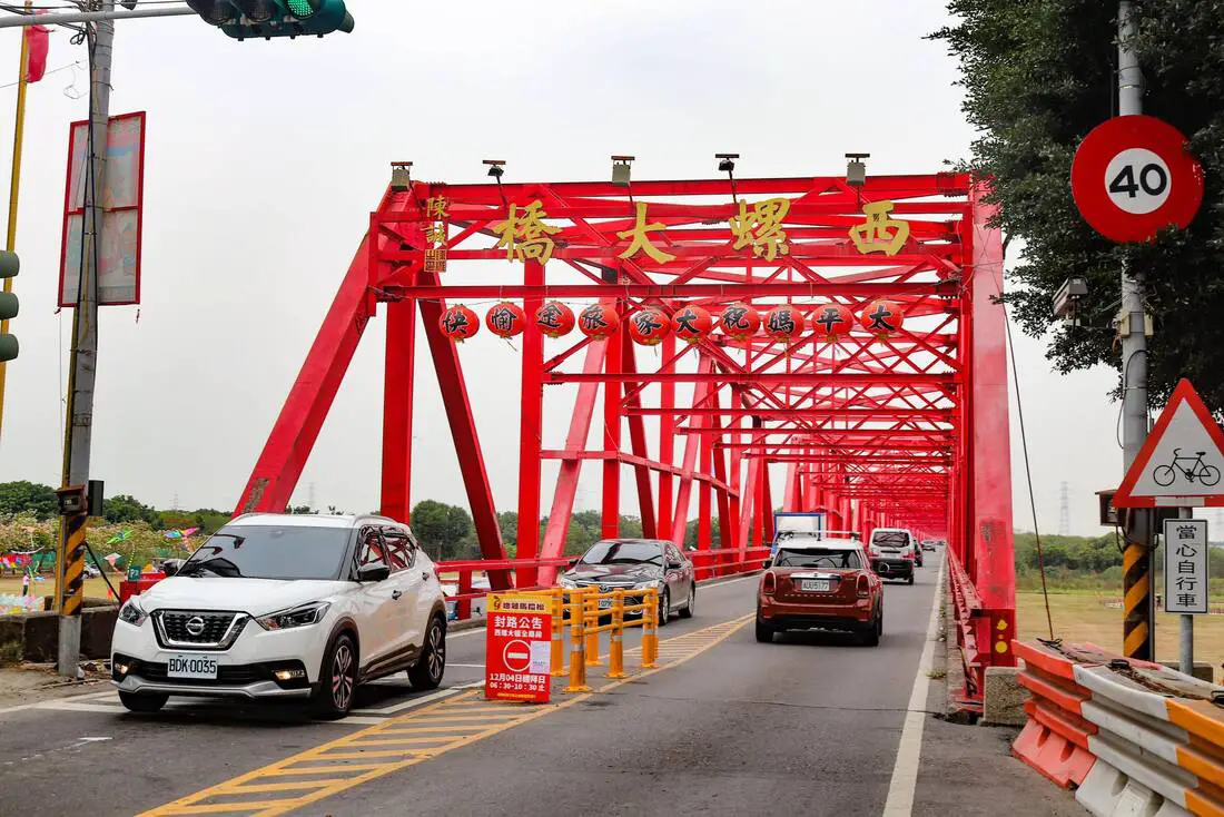
Xiluo Bridge (aka Xiluo Great Bridge) was once the second-longest bridge in the world and connects Yunlin County to Changhua County across the Zhuoshui River. Here you can also find a large public square and grassy park which is free for everyone to enjoy. It is one of Taiwan's historical landmarks that you should not miss.
Historical Background: Before Han Chinese settlement, Xiluo was inhabited by native Taiwanese plains tribal peoples. During the Dutch colonial period, Han Chinese settlers began to migrate and cultivate the land, gradually increasing in number. During the Kingdom of Tungming after Koxinga's conquest of Taiwan from the Dutch, an even larger number of Chinese farmers began to settle here due to the fertile land and mild climate. At the time it was situated in the middle of two other settlements: Lukang and Beigang, making it an important transportation hub from northern to southern Taiwan. There also was a ferry along the Zhuoshui River, further connecting the town to the rest of the world. The Zhushui River also made irrigation easy, and the area is often known as the granary of Taiwan. The Zhuoshui River which the Xiluo River crosses is the longest river in Taiwan and is often considered the boundary between north and south Taiwan. Due to the Zhuoshui River's wide river surface, some early European maps of Taiwan mistakenly divided Taiwan into two islands. During the Japanese era, there were only railway bridges spanning the Zhuoshui River, but no bridges for cars or pedestrians to cross. At that time, people had to cross via ferry or the railway. Starting from the 1920s, the Japanese continued to improve Taiwan's road systems and by the end of 1935, only the Zhuoshui River and the Gaoping River remained impassable by car. In September 1934 the construction of a bridge over the Zhuoshui River was first proposed by local residents. Construction of the bridge began in 1938, with completion scheduled for March 1942. Subsequent construction was halted due to the diversion of steel materials for wartime use, leaving the road incomplete. After WWII, in 1946, the Provincial Assembly proposed to allocate American aid to complete the Xiluo Bridge, with support from local residents. In May 1952, after the steel trusses manufactured with US aid arrived in Taiwan (manufactured by the United States Steel Export Company, which was a front for the US government that could not sell steel directly to Allies), construction resumed. The Xiluo Bridge was completed on December 25, 1952, and officially opened on January 28, 1953. Xiluo Bridge is 1,939 meters long and 7.3 meters wide. It has 31 spans, 32 piers, and a foundation 20 meters deep. It is made from Warren truss steel girders, painted gray-green when opened to traffic in 1952, then repainted gray in January 1962, and changed to red in August 1986. When completed in 1952, the Xiluo Bridge was the world's second-largest bridge after the Golden Gate Bridge in San Francisco, USA. It was also the longest bridge in Taiwan at the time, earning the title of the "largest bridge in the Far East." After the completion of the Xiluo Great Bridge in 1952, the town continued as a transportation hub linking north and south Taiwan. However after the completion of National Freeway 1 in 1978, the bulk of traffic moved onto the new highway and Xiluo turned into somewhat of a rural backwater, with most of its economy based on agriculture. Currently, the population of the town is about 44,000 and is falling every year. Although usually not especially busy, the old street usually has tourists and shoppers and is full of interesting historical buildings. Where to stay: We have stayed at and recommend Ai Ni Ya Hotel, with great quality and service right in downtown Beigang (book on Agoda here or Booking.com here). We also recommend the Grand Earl Hotel, a high class hotel in central Douliu (book on Agoda here or Booking.com here) Looking for a hotel? We recommend booking through Agoda here, which provides the best quality selection of accommodation on the islands. Find out where to stay in our Taiwan hotels guide or search for the best hotel deals in Taiwan here. Tours in Yunlin: Tours and activities in Yunlin include Janfusun Fancy World Amusement Park, Kite Surfing, Tree Climbing , Chaoyang Green Energy Farm, Sam Siu Garden, Pink Castle Park, Gukeng Green Tunnel, Caoling Highway, and more. You can find more tours of Yunlin on Klook here or KKday here. Just to let you know, if you book using the links above, we get some commission at no cost to you, and you can help support our blog. You can click here to receive $5 USD on your first Klook purchase. How to get there: By Scooter: From Provincial Highway 1, go south to the Xiluo Great Bridge until you reach Xiluo Town. There is free parking on the side of the road. Looking for scooter rental in Yunlin? Check out Klook here or KKday here to search for options. You can also check out our scooter rental guide here. By Car: From National Freeway 1, get off at the Xiluo Exit and keep going until you reach Xiluo Town. There is free parking on the side of the road. If you are looking for car rentals, you can also search Qeeq here, Klook here, or KKday here. You can also check out our car rental guide here. By Bus/Train: From Yunlin HSR Station, you can take bus 88 for about 30 minutes to Xiluo Town. You can also book tickets to travel to Yunlin via inter-city bus on Klook here. You can book tickets to Yunlin via high speed rail (HSR) on Klook here or KKDay here. Book tickets via the normal train (TRA) on Klook here. By Bicycle: Cycling is the best way to enjoy Taiwan's landscapes if you have the time and energy. Looking for bicycle rentals in Taiwan? You can search on KKday here and search for tours on Klook here. You can also check out our Taiwan cycling guide here. Map: Please see below: 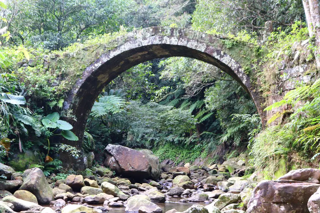
Pudu Changsheng Bridge is known as the most beautiful bridge in northern Taiwan. It is an old stone bridge that was built in 1953 to connect two small villages in the mountains of Shiding District. Now it is a popular spot for hikers and photographers.
Background: Puduchangsheng Bridge was finished in July 1953, to connect two mountain villages: Yuguiling Village (玉桂嶺村) and Fengtou Village (峰頭聚落) in Shiding. People had been living in these mountain villages since1887 during the Qing Dynasty. The trail between the two villages is about 650 meters long. The cost of the bridge construction was donated by the local villagers. Even though Yuguiling Road has now been built to connect the villages, the bridge still stands as a beautiful monument to the past. Hours: 24/7 Price: Free Tours: You can book a tour to Shiding on TripAdvisor here, Klook here or KKday here. Hotels in Taipei: We have stayed at and recommend the Yuanshan Grand Hotel, once the tallest building in Taiwan and still the most grand (book on Booking.com here, Tripadvisor here, or Agoda here). We have stayed at and also recommend Fu Chang Hotel in Ximending, which is within walking distance of Ximending shopping district (book on Booking.com here, Tripadvisor here, or Agoda here). Looking for a hotel? We recommend booking through Booking.com here, which provides the best quality selection of accommodation in Taiwan. Find out where to stay in our Taiwan hotels guide or search for the best hotel deals in Taiwan here. How to get there: By Car Scooter: Take highway 106 east through Shiding until you reach the large U shaped bridge before Yongding Village. Do not get on the bridge, and take a right under the bridge up the mountain valley. Keep going straight until you reach Yuguiling Road, and turn left. Keep going until you see the bridge on your right side after about 500 meters. Looking for scooter rental in Taipei? You can search on Klook here or KKday here to search for options. You can also check out our scooter rental guide here. If you are looking for car rentals, you can also search Qeeq here, Klook here, or KKday here. You can also check out our car rental guide here. By Bus: Take bus 795 from Shiding until you reach Tengliaokeng 藤寮坑 station. From there it is about 4 KM or one hour to get to the bridge, not ideal. You can also book tickets to travel to Shiding via inter-city bus on Klook here. You can also book a Taipei Sightseeing: Hop On, Hop Off Open Top Bus on TripAdvisor here. By Bicycle: Cycling is the best way to enjoy Taiwan's landscapes if you have the time and energy. Looking for bicycle rentals in Taiwan? You can use Taiwan's many Youbike sharing stations, or search for rentals on KKday here, and search for tours on Klook here. You can also check out our Taiwan cycling guide here. You can also book a Sunset Riverside Bike Ride and Historical Tour, 4 Hour Cycling in Taipei, Ultimate 8-Hour Cycling City Tour, or Taipei City Bike Tour with Night Market Experience on TripAdvisor here. For more information, check out our Taiwan transportation guide here. Map: Please see below: 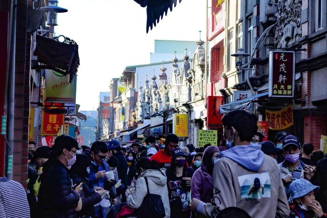
Daxi Old Street is one of the largest and busiest old streets in Taiwan, known for its dried tofu delicacies, and old Taiwan feel. Here one can enjoy delicious food, beautiful scenery, and buy nostalgic Taiwan related souvenirs. This may be the biggest and best old street in Taiwan, so you should definitely stop by here on your next trip to northern Taiwan.
Background: The area around Daxi Old Street was originally inhabited by Ayatal Ingenious people. It's original name was Daguxian, which means great water. In about 1818, Han Chinese settlers came to cultivate the area, and used the Dahan River as a means of transporting goods. The Dahan River did not have a problem with silting, which means it remained a major water transportation hub long after other river ports in northern Taiwan. During the Japanese Era, the streets were planned out along the old street, with most commercial activity happening on Heping Road 和平路, Zhongshan Road 中山路, Xinnan Street 新南路, and surrounding alleys. During this time, the old street was a major transportation hub for camphor, dried tofu, rice, and tea. Currently the old street is one of the largest and best preserved in Taiwan, and is a popular weekend destination due to its proximity to greater Taipei. Delicacies: Local delicacies at Daxi Old Street include peanut brittle and dried tofu. Wood carving shops are also well known here, Hours: Every Day from about 9 AM to 6 PM, with more shops opening later in the day. Price: Free When to go: If you go during weekends or holidays, it can get really crowded but that is also the time when most all of the shops and stalls are open. If you want to avoid the crowds you can try going early in the morning when it is not as busy. Tours: You can book a tour to Daxi Old Street on TripAdvisor here, Klook here, or KKday here. Hotels near Daxi: We have stayed at and recommend the Yuanshan Grand Hotel, once the tallest building in Taiwan and still the most grand (book on Booking.com here, Tripadvisor here, or Agoda here). We have stayed at and also recommend Fu Chang Hotel in Ximending, which is within walking distance of Ximending shopping district (book on Booking.com here, Tripadvisor here, or Agoda here). Looking for a hotel? We recommend booking through Booking.com here, which provides the best quality selection of accommodation in Taiwan. Find out where to stay in our Taiwan hotels guide or search for the best hotel deals in Taiwan here. How to get there: By Car/Scooter: Take local highway 116 east to Daxi from Taoyuan by scooter, or National Freeway 3 by car. Then taken provincial highway 3 to the old street. You can park across the river and walk to the old street via the suspension bridge, or try to find limited parking near the old street on the other side of the river. Looking for scooter rental in Taipei? You can search on Klook here or KKday here to search for options. You can also check out our scooter rental guide here. If you are looking for car rentals, you can also search Qeeq here, Klook here, or KKday here. You can also check out our car rental guide here. By Bus: From Taoyuan TRA station, you can take bus 5096 to the old street. You can also book tickets to travel to Shifen via inter-city bus on Klook here. You can also book a Taipei Sightseeing: Hop On, Hop Off Open Top Bus on TripAdvisor here. By Bicycle: Cycling is the best way to enjoy Taiwan's landscapes if you have the time and energy. Looking for bicycle rentals in Taiwan? You can use Taiwan's many Youbike sharing stations, or search for rentals on KKday here, and search for tours on Klook here. You can also check out our Taiwan cycling guide here. ​You can also book a Sunset Riverside Bike Ride and Historical Tour, 4 Hour Cycling in Taipei, Ultimate 8-Hour Cycling City Tour, or Taipei City Bike Tour with Night Market Experience on TripAdvisor here. For more information, check out our Taiwan transportation guide here. Map: Please see below: 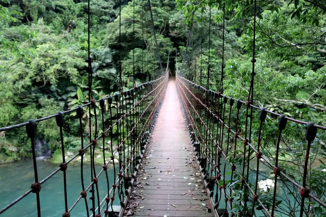
Kuolai Old Trail was a major intersection along the Danlan Old Trail that connects Keelung to Yilan through the mountains of New Taipei. There are three pedestrian bridges, multiple camping locations, lots of swimming spots, and beautiful views of the surrounding mountains. Also, there are some great hiking trails along multiple sections of the original Danlan Old Trail to discover.
Background: Kuolai was originally a small village create in the late Qing Dynasty. In the early days during the Qing Dynasty, the Han Chinese settlers here mainly grew tea and leeks. During the Qing Dynasty, Kuolai was an important stop along the Danlan Old Trail (淡蘭古道 which means the road between Tamsui and Yilan), which was split into three paths, and Kuolai was on the middle path. The middle path winded from Nuannuan to Shifen, then to Kuolai, and then finally over the mountains to Wai'ao in Yilan. Part of section connecting Kuolai to Wai'ao through Wantan is known as the Wantan Old Trail. Kuolai also intersects with the Beishi River Old Trail which connects Shuangxi to Pinglin. During the Japanese Era until the 1980s, the major industry in the area besides tea growing was coal mining, The coal mining industry winded down in the 1980s and 90s in Taiwan. Currently Kuolai is a popular stop near National Highway 5 in northern Pinglin. Besides the history, there is also some great hiking trails and scenery nearby. Price: Free Hours: About 8 AM to 5 PM. Tours and Activities: Here you can river trace, SUP / Paddleboard, and more on KKday here. Hotels in Taipei: We have stayed at and recommend the Yuanshan Grand Hotel, once the tallest building in Taiwan and still the most grand (book on Booking.com here, Tripadvisor here, or Agoda here). We have stayed at and also recommend Fu Chang Hotel in Ximending, which is within walking distance of Ximending shopping district (book on Booking.com here, Tripadvisor here, or Agoda here). Looking for a hotel? We recommend booking through Booking.com here, which provides the best quality selection of accommodation in Taiwan. Find out where to stay in our Taiwan hotels guide or search for the best hotel deals in Taiwan here. How to get there: By Car: Go east on National Freeway 5, then get off at the Pinglin interchange. Continue north east on Pingshuang Road, which follows the Beishi River Old Trail. You can find the many suspension bridges on the side of the road. If you are looking for car rentals, you can also search Qeeq here, Klook here, or KKday here. You can also check out our car rental guide here. By Scooter: From Taipei, take highway 106 east from Shenkeng toward Shiding, pass over the mountain to Pinglin, then once in Pinglin continue north east on Pingshuang Road, which follows the Beishi River Old Trail. You can find the many suspension bridges on the side of the road. Looking for scooter rental in Taipei? You can search on Klook here or KKday here to search for options. You can also check out our scooter rental guide here. By Bus: From Taipei City Call MRT station, you can take bus 912 to Bafenliao Station, the switch to bus 923 to Pinglin Station. The ride should take about 2 hours. From Pinglin, you can take the F721 bus up along the Beishi River Old Trail. This will take up a lot of time. You can also book tickets to travel to Pinglin via inter-city bus on Klook here. You can also book a Taipei Sightseeing: Hop On, Hop Off Open Top Bus on TripAdvisor here. By Bicycle: Cycling is the best way to enjoy Taiwan's landscapes if you have the time and energy. Looking for bicycle rentals in Taiwan? You can use Taiwan's many Youbike sharing stations, or search for rentals on KKday here, and search for tours on Klook here. You can also check out our Taiwan cycling guide here. You can also book a Sunset Riverside Bike Ride and Historical Tour, 4 Hour Cycling in Taipei, Ultimate 8-Hour Cycling City Tour, or Taipei City Bike Tour with Night Market Experience on TripAdvisor here. For more information, check out our Taiwan transportation guide here. Map: Please see below. 
Bitan is a slow moving part of the Xindian River in Xindian District of New Taipei. It is also known as Bitan Lake, or Bitan Scenic Area (碧潭風景區). Here you can bike ride, paddle boat, go hiking, and shop at Xindian Old Street (新店老街). With convenient transportation via Taipei MRT, it is definitely worth a stop on your trip to Taipei.
Background: The name Bitan means "green lake" in Chinese, which was coined by Sun Ke, vice chairman of the KMT after WWII. It is also known as Chibi Lake (赤壁潭)、Shibi Lake (石壁潭)、and Shishan Big Lake (獅山邊大潭). Bitan suspension bridge was completed in 1937. Before that time, ferry boat was the best means of transport. In 1997, the National Freeway 3 bridge was completed across the lake. In 2000, Bitan Suspension Bridge was refurbished. It is also known as one of Taiwan's top 12 or top 8 sights. It is also a very popular recreational spot for Taipie residents on the weekend. Near Bitan is Xindian Old Street (新店老街), which sells street food, fruits, and vegetables. It has been the main acrigultural market in Xindian for over a hundred years. The Changxing Temple on the Old Street (長興宮) is over 150 years old, and is dedicated to the Earth God. Hours: About 8 AM to 10 PM. Price: Free entrance Ferry boat: 20 NT one way Paddle boats: 300 NT for a two person boat, more for more people or electric boats Bike rental: 15-70 NT per hour depending on the bike SUP Paddle Boarding: 2000-3000 NT You can book an SUP / Stand up Paddle boarding experience at Bitan on TripAdvisor here, Klook here, or KKday here. Tours and Activities: You can book an SUP / Stand up Paddle boarding experience at Bitan on TripAdvisor here, Klook here, or KKday here. How to get there: By MRT: Take the Green Line MRT south to Xindian Station, or Xiaobitan Station. Xindian Old Street is within walking distance of Xindian Old Street. From Xiaobitan Station, you can rent a bike and ride up the river to Xindian Old Street. You can also book an MRT travel pass on Klook here. By car/scooter: From Taipei, go south on provincial highway 9 until you reach Xindian Old Street. There is paid parking near the old street. Looking for scooter rental in Taipei? You can search on Klook here or KKday here to search for options. You can also check out our scooter rental guide here. If you are looking for car rentals, you can also search Qeeq here, Klook here, or KKday here. You can also check out our car rental guide here. By Bicycle: Cycling is the best way to enjoy Taiwan's landscapes if you have the time and energy. Looking for bicycle rentals in Taiwan? You can use Taiwan's many Youbike sharing stations, or search for rentals on KKday here, and search for tours on Klook here. You can also check out our Taiwan cycling guide here. You can also book a Sunset Riverside Bike Ride and Historical Tour, 4 Hour Cycling in Taipei, Ultimate 8-Hour Cycling City Tour, or Taipei City Bike Tour with Night Market Experience on TripAdvisor here. For more information, check out our Taiwan transportation guide here. Map: Please see below: 
Longmen is a scenic coastal biking area near Fulong Beach. Here you can also find sand dunes, a camp ground, and a large sports part. It is a great place to go cycling and enjoy the ocean views.
Background: "The total distance of Lingmen bikeway is about 5 kilometers, the scenery along the route is very beautiful with green grass, river, and birds. The sea wave is magnificent, you can stand there to look Bitou Cape, Scenery of Laolan Mountain, and sunrise. The natural scenery such as Pacific Ocean, Shuangxi River, Longmen Park, and Yanliao Park, you can ride a bike with your family members to enjoy the scenery here." Fulong Beach lies next to Fulong Village in Gongliao District of New Taipei, at the mouth of the Shuang River. It is special in Taiwan for its rare golden color. The beach has been a popular swimming destination since the Japanese occupation of Taiwan. In 1959, the TRA created public showers and bridge that goes to the other side of the sandbar that you see today. The Fullon hotel resort sits in front of the paid beach and is a popular destination for Taipei residents. Taiwan's fourth nuclear reactor lies in the background of the beach, but it has never been operational and likely never will be due to the anti-nuclear power movement in Taiwan. Near the beach one can go camping at Longmen campground or biking on the Caoling bicycle loop. Price: Free Hours: 24/7 Tours and Activities: There are many activities available here at Longmen such as Windsurfing, SUP /paddle boarding, kayaking, canoeing, sailing, and more on Klook here or KKday here. You can also book tickets to the international Sand Sculpture Art festival on Klook here or KKday here. When to go: May to October when the weather is nice and the water is warm. Winter on the northeast coast is cold and windy. Fulong sand sculpture season dates: April 19th - August 25th (2019). Hotels in Fulong: We recommend Fullon Hotel which has locations in Tamsui and Fulong near the beach (book on Booking.com here, Tripadvisor here, Agoda here, or Hotels.com here). We have also stayed at and recommend Hai Xia Your Home which is right in front of Fulong Beach (book on Booking.com here, Tripadvisor here, Agoda here, or Hotels.com here). Looking for a hotel? We recommend booking through Booking.com here, which provides the best quality selection of accommodation in Taiwan. Find out where to stay in our Taiwan hotels guide or search for the best hotel deals in Taiwan here. How to get there: By Train: Take the TRA train to Fulong Station. Walk straight from the station down to the beach! Book tickets via the normal train (TRA) on Klook here. By Car/Scooter: Take provincial higway 2 from Qidu in Keelung through the mountains past Shifen and Shuangxi until you reach Gongliao on the coast. The beach is right in front of the train station, and there is free parking in front of Dongxing Temple. Looking for scooter rental in Keelung? Search KKday here for options. You can also check out our scooter rental guide here. If you are looking for car rentals, you can also search Qeeq here, Klook here, or KKday here. You can also check out our car rental guide here. By Bicycle: Cycling is the best way to enjoy Taiwan's landscapes if you have the time and energy. Looking for bicycle rentals in Taiwan? You can use Taiwan's many Youbike bike sharing stations, or search for rentals on KKday here, and search for tours on Klook here. You can also check out our Taiwan cycling guide here. For more information, check out our Taiwan transportation guide here. Map: Please see below: 
Lovers Lake is a small lake a recreation area in Anle District of Keelung City. It has some easy trails, bridges, and a tower that looks over the area. The lake trails also connect to Dawulun Fort. Overall it is a nice scenic spot for a day trip in Northern Taiwan.
Background: The name "Lovers Lake" comes from the fact that there are actually two lakes, one larger and one smaller, so they are a like a couple in love. The sandstone that forms the area was created between 10 and 20 million years ago, and was pushed out of the sea along with northern Taiwan thousands of years ago. In the past the area was run by a private company, which went out of business. Recently the Keelung City government has taken over control, and has installed a trail that circles the lake. There is also a suspension bridge, windmill, and stone tower overlooking the lake. Nearby you can hike to Dawulun Fort or Eagle Rock that provide great views of the north coast. Currently the lake is popular with hikers and intagrammers, as well as wedding photographers. On the weekends it can get quite busy and parking can be hard to find. Hours: 24/7 Price: Free Tours: You can book a hiking tour of Lover's Lake on KKday here. Activities: Don't forget that there are many activities available along Taiwan's Northern Coast such as Yachting, Fishing, Surfing, SUP / Paddle Boarding, Diving, Snorkeling Kayaking, Canoeing, Water Biking, River Tracing / Canyoneering, Glamping, Motorcycling, Motorbike Tour, Shen'ao Rail Bike, Night Fishing, Instagram Tour, Metaverse VR experience, Seaside Picnic, and more on Tripadvisor here, Klook here, or KKday here. Hotels in Keelung: We recommend Just Live Inn-Keelung and Yung Feng Hotel, which are two great quality hotels for a reasonable price in Keelung's City Center. You can book Just Live Inn-Keelung on Booking.com here, Agoda here, Klook here, Hotels.com here, Trip.com here, or Kayak here. You can book Yung Feng Hotel on Booking.com here, Agoda here, Hotels.com here, Trip.com here, Klook here, or Kayak here, How to get there: By car/scooter: Take provincial highway northwest out of Keelung, and take a right on Jijin First Road toward Keelung Chang Kung Hospital. The Lover's lake parking lot is at the top of the hill before the road turns into one lane. There is limited parking, and you may have to park further away. The trail is not wheelchair or stroller friendly. However there is always plenty of scooter parking. If you are looking for car rentals, you can also search Qeeq here, Klook here, or KKday here. You can also check out our car rental guide here. Looking for scooter rental in northern Taiwan? You can search on Klook here or KKday here to search for options. You can also check out our scooter rental guide here. By Bicycle: Cycling is the best way to enjoy Taiwan's landscapes if you have the time and energy. Looking for bicycle rentals in Taiwan? You can use Taiwan's many Youbike sharing stations, or search for rentals on KKday here, and search for tours on Klook here. You can also check out our Taiwan cycling guide here. You can also book a cycling tour on TripAdvisor here. For more information, check out our Taiwan transportation guide here. By Bus: Unfortunately there are no buses that directly get there, so you will have to walk from provincial highway 2, or take a taxi. You can purchase a discount easy card to use on the MRT and buses from Klook here or KKday here. You can also book an MRT travel pass on Klook here. Map: Please see below: 
Lengshuikeng in Yangmingshan National Park is a small area with hiking trails, natural hot springs, waterfalls, and wildlife. Even though the name means "cold water hole," the water here is not cold, and there are plenty of hot springs around including a public hot spring bath house. It is a quiet a pleasant stop on the mountain and worth a visit on your trip to Yangmingshan.
Background: The area known as Yangmingshan now was formed by volcanoes about 700,000 years ago, forming many mountains about 1000 meters or less in northwestern Taiwan. The park still features active volcanoes, vents, and hot springs. The original name of the area was Caoshan (grass mountain 草山). During the Qing Dynasty, the area was used to harvest sulfur, and many of the hills were burned to help catch sulfur thieves. In 1927 during the Japanese era, Yangmingshan was made as the first national park in Taiwan, then known as Datunshan National Park Association. In 1950 after the ROC took Taiwan Chiang Kai-shek renamed the park after the philosopher Wang Yangming, and called the area Yangmingshan. In 1985, after resolving many land disputes, Yangmingshan National Park was officially designated as a national park in the ROC era. Lengshuikeng (literally "cold water crater" gets its name because the hot spring waters here are only 40 degrees centigrade, the coldest hot spring waters on Yangmingshan. Lengshuikeng has the only sulfur deposit sediment layer in Taiwan. Nearby are many hot springs and vents. It is a popular stop in Yangmingshan and has two parking lots and visitor's center. Hours: The visitor's center is open from 9 AM to 4:30 PM. Price: Free You can book tours to Yangmingshan on TripAdvisor here, Klook here, or KKday here or here. Tours: You can check out tours to Yangmingshan such as a One-day Yangmingshan NP Beitou Hot Spring Park and Tamsui Tour Package, Beitou and Yangmingshan Day Tour from Taipei, One Day Hike around Yangmingshan, or Private Yangmingshan Volcano Tour and more on TripAdvisor here, Klook here, or KKday here. How to get there: By Car/Scooter: From Taipei, take provincial highway 2A north to Chungshan Hall, and take a right, then continue down the road up the mountain to the left until you reach Lengshuikeng. Looking for scooter rental in Taipei? Check out Qeeq here, Klook here, or KKday here to search for options. You can also check out our scooter rental guide here. If you are looking for car rentals, you can also search Qeeq here, Klook here, or KKday here. You can also check out our car rental guide here. By Bus: From Shilin MRT Station, take bus S15 to Lengshuikeng Service Station. You can book tickets to travel to Taipei via inter-city bus on Klook here. By Bicycle: Cycling is the best way to enjoy Taiwan's landscapes if you have the time and energy. Looking for bicycle rentals in Taiwan? You can use Taiwan's many Youbike sharing stations, or search for rentals on KKday here, and search for tours on Klook here. You can also check out our Taiwan cycling guide here. You can also book a Sunset Riverside Bike Ride and Historical Tour, 4 Hour Cycling in Taipei, Ultimate 8-Hour Cycling City Tour, or Taipei City Bike Tour with Night Market Experience on TripAdvisor here. Map: Please see below: 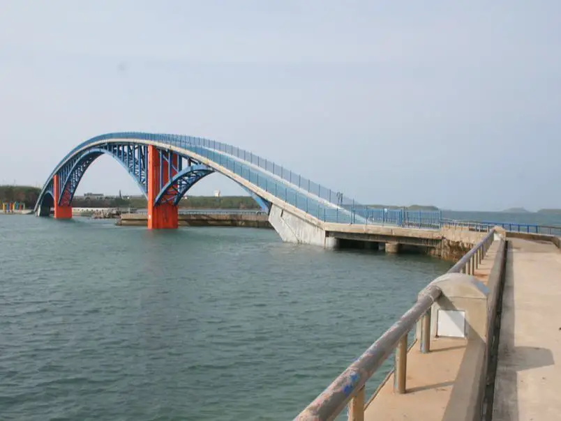
Guanyin Temple Swimming Area (aka. Guanyinting, Guanyin Temple Leisure Park, and Guanyinting Recreation Area) is one of the main tourist attractions in Magong and Penghu. It is a relaxing place to enjoy views of the ocean and the sunset, as well as other activities such as jogging, swimming, parasailing, and fishing.
Price: Free! Hours: Open all day every day. Tours: There are many tours and activities available on the islands such as snorkeling, diving, wind surfing, sailing, canoeing, starlight Marine Ranch, wakeboarding, seafood Barbeque, massage, yachting, glamping, trampoline Water Sports, South Penghu Marine National Park, SUP / Paddle Boarding, kayaking, night fishing, Sheraton Four Points Eatery, Dragon Palace Intertidal Zone, Jibei Sand Tail, and many more options. For more information, look at other tour/ferry sites or book a personalized tour with Klook here or KKday here. Accommodation: We have stayed at and recommend Han's Hostel which had great service and is right next to Shanshui Beach, the best beach in Penghu (you can book on Agoda here, Booking.com here, or Trip.com here), and Cherry Inn Penghu, a newly renovated homestay in downtown Magong with great service and great prices (you can book on Agoda here, Booking.com here, Klook here, Trip.com here, Hotels.com here, or Expedia here). Looking for a hotel? We recommend booking through Agoda here, which provides the best quality selection of accommodation on the islands. You can also find out more about where to stay in our Taiwan hotels guide here. You can also book Wifi and SIM cards for Taiwan on Gigago here. Need travel insurance? Compare prices on Insubuy here. Just to let you know, if you book using the links above, we get some commission at no cost to you, and you can help support our blog. You can click here to receive $5 USD on your first Klook purchase. How To Get There: It lies on the very west part of Magong City. It's really quite hard to miss. By Car/Scooter: The best way to get there is via scooter or car from Magong. But be careful to park in a designated spot because the cops there are strict. You can rent a scooter in Penghu on Klook here or on KKday here. You can also check out our scooter rental guide here. You can rent a car for Penghu on Klook here or on KKday here. You can also check out our car rental guide here. By Bicycle: Cycling is the best way to enjoy Taiwan's landscapes if you have the time and energy. Looking for bicycle rentals in Taiwan? You can search on KKday here and search for tours on Klook here. You can also check out our Taiwan cycling guide here. By Bus: a bus is possible on the main island, but it will be slower and more unpredictable. Take a tour: You can book a tour to Penghu including transportation on Klook here or KKday here. Map: Please see below: 
Nantou's Houtanjing Sky Bridge (aka just Sky Bridge) is a tourist attraction near Nantou City, which features great views of Yuanlin and Changhua county. If you visit Nantou, this place should definitely be on your list.
Background: Nantou Sky Bridge was built in 2009 at a price of 20 million NT by the Houtanjing National Scenic area. It is 204 meters long, and sits 70 meters above the valley below. Only 150 people are allowed on the bridge at a time. Hours: 8:30 to 5:30 Price: 50 NT per person Tours: You can book a tour to Jiji and Nantou Sky Bridge on Klook here. Accommodation: We have stayed at and recommend Jenq Yang Hotspring Hotel (you can book on Agoda here, Booking.com here, Trip.com here, or Klook here), a hot spring hotel near the mystical Lushan hot spring, and Maple Leaf Holiday Villa (you can book on Agoda here, Booking.com here, Hotels.com here, Expedia.com here, Trip.com here, or Klook here), a lodge with a great view and within walking distance of Cingjing Farm. I also have stayed at and recommend Kirin Villa (you can book on Agoda here or Booking.com here), a mountain resort in Puli near Sun Moon Lake. Looking for a hotel? Find out where to stay in our Taiwan hotels guide or search for the best hotel deals in Taiwan here. We recommend booking through Agoda here, which provides the best quality selection of accommodation on the islands. You can also book Wifi and SIM cards for Taiwan on Gigago here. Just to let you know, if you book using the links above, we get some commission at no cost to you, and you can help support our blog. You can click here to receive $5 USD on your first Klook purchase. How to get there: By Car/Scooter: Take highway 139 from Nantou City up the mountain until you reach the bridge. If you are looking for car rentals, you can also search Qeeq here, Klook here, KKday here. You can also check out our car rental guide here. Looking for scooter rental in Nantou? Search Klook here or KKday here to search for options. You can also check out our scooter rental guide here. By Bus: From Yuanlin TRA Station, you can take Changhua Bus 6925A to Xiaping, and from there it is about a ten minute walk to the bridge. You can book tickets to travel to Nantou via inter-city bus on Klook here. You can book tickets to Taichung via high speed rail (HSR) on Klook here or KKDay here, or book tickets via the normal train (TRA) on Klook here, then switch to a bus to Nantou. Bicycle Rental: Cycling is the best way to enjoy Taiwan's landscapes if you have the time and energy. Looking for bicycle rentals in Taiwan? You can search on KKday here and search for tours on Klook here. You can also check out our Taiwan cycling guide here. Map: Please see below: 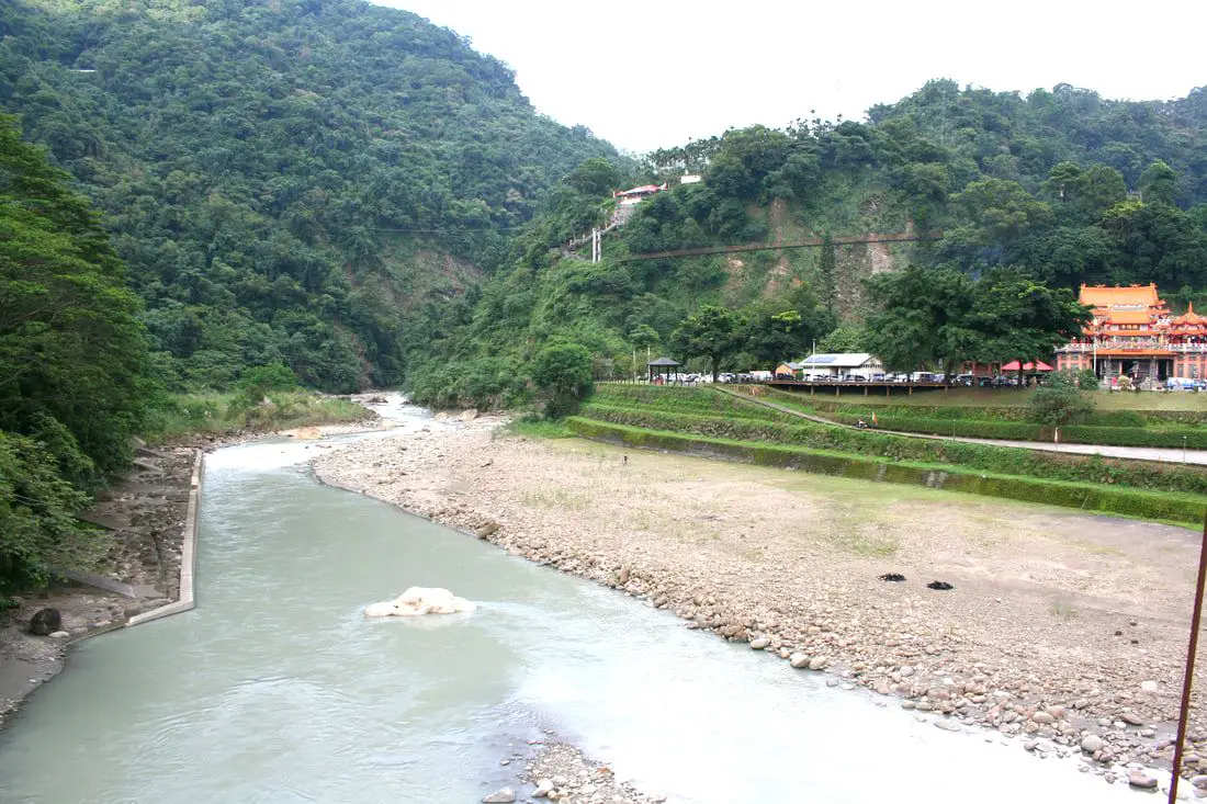
Chukou Village in Fanlu Township (番路鄉) of Chiayi is a pleasant stop along the Alishan Highway, It features multiple suspension bridges, mountain temples, rivers and waterfalls, and lots of hikes. If you have time you should definitely stop here and enjoy the scenery.
Background: Fanlu gets its name from the Cou Tribe that named the area Fan Village, and was an important trading spot between Han Chinese settlers and indigenous tribes-people. Fanlu Township was briefly a part of Tainan county after WWII, but was moved back to Chiayi county in 1951. Currently it has 11,000 residents. When the Alishan Forest Railway is damaged, this placed becomes an important stop for many travelers along the Alishan Highway. Hours: 24/7 Price: Free Tours and Activities: You can purchase tours and tickets for many activities in Chiayi such as glamping, Three Pigs Farm, Janfusun Fancy World, Taiping Suspension Bridge, Chateau de Jourdeness , Kumquat Tourist Factory, Taisugar Siantou Cultural Park, Meteor Garden, Veoveoana Tribe Tour, Danayi Valley, Batongguan Historic Trail, Xianghe Leisure Farm, Foot massage and many others through Klook here or KKday here. Accommodation: We have stayed at and recommend Chiayi Crown Hotel (you can book on Agoda here, Booking.com here, Hotels.com here, or Expedia here), Shin Kao Hotel (you can book on Agoda here or Trip.com here), and YesHotel (you can book on Agoda here, Booking.com here, Hotels.com here, or Expedia here), which are all quality hotels for a reasonable price near Chiayi Station. We also recommend Shianghu Botique Hotel (you can book on Agoda here, Booking.com here, Hotels.com here, or Expedia here), with excellent quality for the money just our of Chiayi City center. Finally we have stayed at and recommend Fenchihu Street Hotel (you can book on Agoda here, Booking.com here, Hotels.com here, or Expedia here), which is within walking distance of Fenqihu Old Street, Fenqihu Station, and many amazing hikes in the area. Find out more about where to stay in our Taiwan hotels guide or search for the best hotel deals in Taiwan here. We recommend booking through Agoda here, which provides the best quality selection of accommodation on the islands. You can also book Wifi and SIM cards for Taiwan on Gigago here. Need travel insurance? Compare prices on Insubuy here. Just to let you know, if you book using the links above, we get some commission at no cost to you, and you can help support our blog. You can click here to receive $5 USD on your first Klook purchase. How to get there: By Car/Scooter: From Chiayi, take provincial highway 18 east until you reach the first switchbacks up the mountain. Chukou Village is at the base of the mountain; it's hard to miss. If you are looking for car rentals, you can also search Qeeq here, Klook here, or KKday here. You can also check out our car rental guide here. Looking for scooter rental in Chiayi? You can check out Klook here or KKday here to search for options. You can also check out our scooter rental guide here. By Bus: From Chiayi Bus Station, take bus 7216A to Chukou Station (about 1.5 hours). You can book tickets to travel to Chiayi via inter-city bus on Klook here. Map: Please see below: 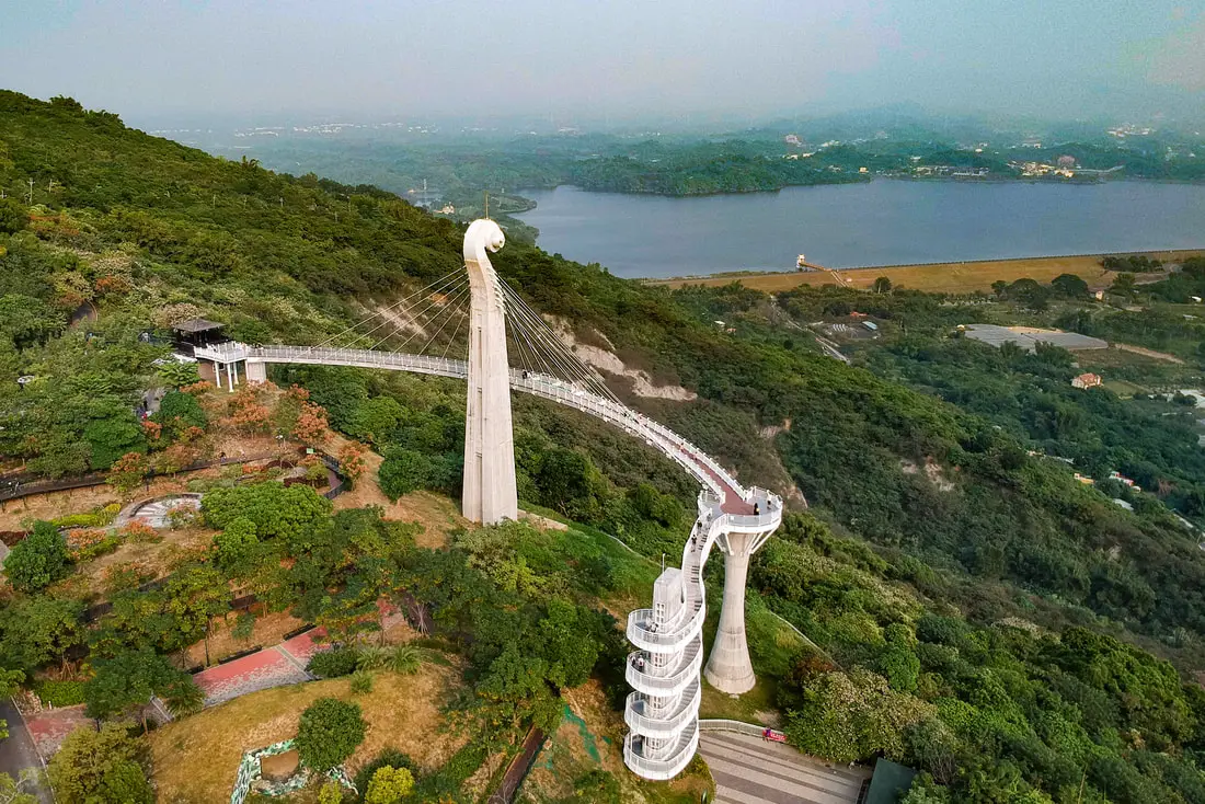
Gangshan's Skywalk Bridge (aka Xiaogangshan Skywalk Park) is a tourist attraction in Gangshan District of Kaohsiung, which features great views of Agongdian Reservoir and norther Kaohsiung City. The bridge is in the shape of a violin, and there is constant music playing here. If you visit Kaohsiung, this place should definitely be on your list.
Background: Siaogangshan Skywalk Park was completed in 2018 at the price of 128,000,000 NT. It is 40 meters tall and 88 meters wide. It officially opened February 14th, 2018. The main pylon resembles a violin and includes 24 suspension cables that look like violin strings. It's Chinese name literally means "the eye of Gangshan." Hours: 9 AM to 9 PM, closed Mondays Price: 60 NT per person Tickets are free until the end of December 2020! How to get there: By Car/Scooter: Take Jiaxing East Road east out of Gangshan until it becomes Dazhuang Road, then park at the parking lot in front of the dam. There is a shuttle bus that will take you to the top of the mountain for 25 NT per trip. Vehicle traffic is not allowed up the mountain. The shuttle bus comes about every half hour. Looking for scooter rental in Kaohsiung? You can check out Klook here or KKday here to search for options. You can check also out our scooter rental guide here. If you are looking for car rentals, you can search Qeeq here, KKday here, or Klook here. You can also check out our car rental guide here. By Bus: From Gangshan MRT Station, take buys R68 A or B to Siaogangshan Station. The trip takes over an hour. You can book tickets to travel to Kaohsiung via inter-city bus on Klook here. You can book tickets to Kaohsiung via high speed rail (HSR) on Klook here or KKDay here. Book tickets via the normal train (TRA) on Klook here. You can also book a Kaohsiung Travel pass here. Accommodation We have stayed at and recommend Chao She Hotel (you can book on Agoda here, Booking.com here, Hotels.com here, or Expedia here) IHI Sanduo Travel Hotel (you can book on Agoda here, Booking.com here, Hotels.com here, or Expedia here), and Mingli Hotel (you can book on Agoda here, Klook here, or Hotels.com here) which are three inexpensive and high quality choices in downtown Kaohsiung. I also have stayed at and recommend Kaohsiung Meinong Rabbit Paul Homestay B&B (you can book on Agoda here, Booking.com here, or Trip.com here), a quiet B&B in rural Meinong, and Chengching Lakeside Resort (you can book on Agoda here, Booking.com or Trip.com here)and the Grand Hotel Kaohsiung (you can book on Agoda here, Booking.com here, Hotels.com here, or Expedia here) which both offer breakfast buffet and free entrance into Chenqing Lake Park. I have also stayed at the 85 sky tower which offers great views of the city; you can search for rooms in the 85 sky tower on Agoda here, Booking.com here, Hotels.com here, Expedia here, or Trip.com here). Find out more about where to stay in our Taiwan hotels guide or search for the best hotel deals in Taiwan here. We recommend booking through Agoda here, which provides the best quality selection of accommodation on the islands. You can also book Wifi and SIM cards for Taiwan on Gigago here. Need travel insurance? Compare prices on Insubuy here. Tours: You can find more tours and activities in Kaohsiung such as wake boarding, water skiing, SUP paddle boarding, Pier 2, i-Ride Kaohsiung Visual 5D Flying Theater, Ski School Indoor Ski Slope, and more on Klook here or KKday here. Just to let you know, if you book using the links above, we get some commission at no cost to you, and you can help support our blog. You can click here to receive $5 USD on your first Klook purchase. Map: Please see below: 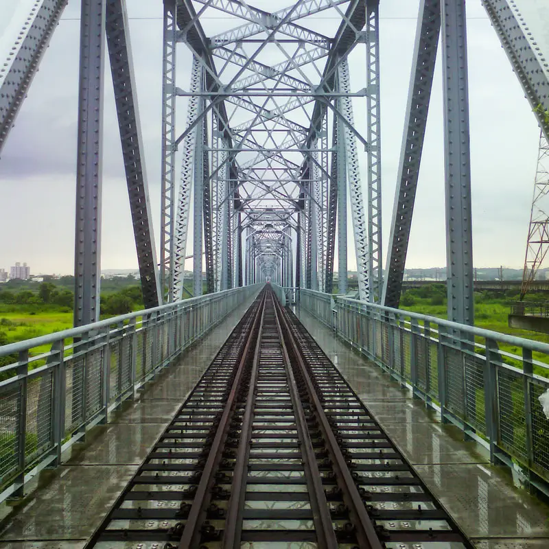
The Gaoping Old Iron Bridge (aka Lower Tamsui River Iron Bridge 下淡水溪鐵橋) is a disused railway bridge across the Gaoping River, formerly connecting Kaohsiung to Pingtung. The bridge was retired in 1987 in favor of a new electrified bridge, and the center section of the bridge was washed away during Typhoon Haitang in 2005. At the time of construction, it was the longest bridge in Asia and the first overland pathway created between Kaohsiung and Pintung. Originally planned to be torn down, it was saved by concerned residents on both sides of the river and now stands as a monument to the past.
Background: The Gaoping Old Iron bridge began construction in 1910 and was completed in 1913. A rail link was needed to ship sugar cane and related products from Pingtung to Kaohsiung Harbor. During the Japanese era, the Gaoping River was known as the lower Tamsui River, hence the name of the bridge was the Lower Tamsui River Iron Bridge. Due to the river's wide banks and strong current, it was a great engineering feat of its time. Along the way many floods halted and destroyed construction. Two months after construction was complete, the railway from Kaohsiung to Pingtung was officially opened. The bridge was 1,526 meters long, 7 meters wide, with trusses 15 meters high. At the time of construction, it was the longest bridge in Asia and the first overland pathway created between Kaohsiung and Pintung. The current trusses on the bridge were built in 1964, to replace the corroding old trusses from the Japanese era. The bridge was retired in 1987 in favor of a new electrified bridge with two tracks as part of the electrification of Taiwan's railway. The bridge was officially retired in 1992. Originally planned to be torn down, it was saved by concerned residents on both sides of the river and was named a national historic monument in 1997. The center section of the bridge was washed away during Typhoon Haitang in 2005, washing out the No. 9, 10, and 11 pillars. No. 12 and 14 pillars were also wiped out in a Typhoon in 2006, and another fell in 2008. In 2018 the wooden cross beams were replaced, which had begun to rot. Currently there are parks on both sides of the river commemorating the bridge, with more people visiting the Kaohsiung side due to its proximity to down town Dashu. Price: Free Hours: 24/7 How to get there: By Car/Scooter: Take provincial highway 29 north to Dashu. Stop when the road goes underneath the railroad. There is plenty of parking nearby. You can also cross the provincial highway 1 bridge to Pingtung and drive to the park on the other side of the bridge. Looking for scooter rental in Kaohsiung? You can check out Klook here or KKday here to search for options. You can check also out our scooter rental guide here. If you are looking for car rentals, you can search Qeeq here, KKday here, or Klook here. You can also check out our car rental guide here. By Train: Take the TRA to Jiuqutang Station. The park is about a five minute walk away. You can also take the TRA to Liukuaicuo Station and walk back west to the park on the east side, but it is about a 3 KM walk. You can book tickets to travel to Kaohsiung via inter-city bus on Klook here. You can book tickets to Kaohsiung via high speed rail (HSR) on Klook here or KKDay here. Book tickets via the normal train (TRA) on Klook here. You can also book a Kaohsiung Travel pass here. Accommodation We have stayed at and recommend Chao She Hotel (you can book on Agoda here, Booking.com here, Hotels.com here, or Expedia here) IHI Sanduo Travel Hotel (you can book on Agoda here, Booking.com here, Hotels.com here, or Expedia here), and Mingli Hotel (you can book on Agoda here, Klook here, or Hotels.com here) which are three inexpensive and high quality choices in downtown Kaohsiung. I also have stayed at and recommend Kaohsiung Meinong Rabbit Paul Homestay B&B (you can book on Agoda here, Booking.com here, or Trip.com here), a quiet B&B in rural Meinong, and Chengching Lakeside Resort (you can book on Agoda here, Booking.com or Trip.com here)and the Grand Hotel Kaohsiung (you can book on Agoda here, Booking.com here, Hotels.com here, or Expedia here) which both offer breakfast buffet and free entrance into Chenqing Lake Park. I have also stayed at the 85 sky tower which offers great views of the city; you can search for rooms in the 85 sky tower on Agoda here, Booking.com here, Hotels.com here, Expedia here, or Trip.com here). Find out more about where to stay in our Taiwan hotels guide or search for the best hotel deals in Taiwan here. We recommend booking through Agoda here, which provides the best quality selection of accommodation on the islands. You can also book Wifi and SIM cards for Taiwan on Gigago here. Need travel insurance? Compare prices on Insubuy here. Tours: You can find more tours and activities in Kaohsiung such as Pier 2, Meinong Hakka Museum, Hamasen Railway Museum, Suzuka Circuit Park, i-Ride Kaohsiung Visual 5D Flying Theater, National Science and Technology Museum , Senya Village Restaruant, Austin Land, Ski School Indoor Ski Slope, and many more on Klook here or KKday here. Just to let you know, if you book using the links above, we get some commission at no cost to you, and you can help support our blog. You can click here to receive $5 USD on your first Klook purchase. Map: Please see below: 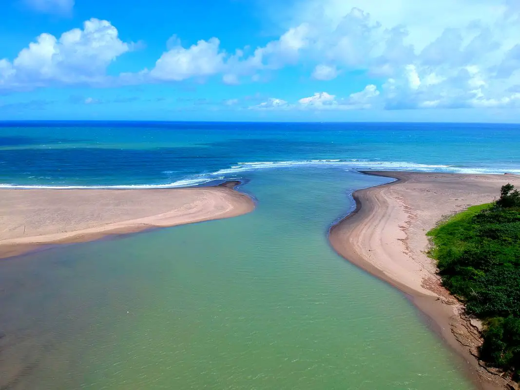
Gangkou Beach near Jialeshui Scenic Area in Kenting is one of the premier surfing beaches in Taiwan, with its most famous landmark being the Gangkou Suspension Bridge which leads to the Diaoqiao Wetland area. Popular activities here include surfing, kite surfing, swimming, and hiking. It is a must see on your trip to Kenting. Due to its location there are rarely crowds here even on weekends.
Background: The area around Gangkou was originally inhabited by the Paiwan Tribe. Afterward, Chinese settlers started moving in to farm the area, and it remains mainly a rural area to this day, with about one fourth of the population being indiginous people. Gangkou suspension bridge is190 meters long and less than 10 meters high. The bridge was built to give passage to locals who in early times had to cross the Gangkou River during winter when it was cold and windy in order to leave town. Gangkou Beach is usually free of crowds due to its location, and there are multiple surf board rentals nearby. Strong winds year round mean there are always constant large waves coming into the bay. Hours: 7:30 AM to 6:00 PM Price: Gangkou Suspension Bridge: 20 NT Parking: Free How to get there: By Bus: Take bus 8247 from Hengchun about half an hour to Gangkou Village. You can book tickets to Pingtung via high speed rail (HSR) on Klook here or KKDay here, or book tickets via the normal train (TRA) on Klook here. You can book tickets to travel to Pingtung via inter-city bus on Klook here. By Car/Scooter: Take Provincial highway 26 to its easternmost point to enter Gangkou Village. There is a parking lot near the suspension bridge with free parking. Looking for scooter rental in Pingtung? Click here or here to search for options. If you are looking for car rentals, you can also search here. Accommodation: I have stayed at many hostels and hotels in Kenting, and even almost bought a house here. Some places that I have stayed at and can recommend are Nanwan Kiki (book on Agoda here, Booking.com here), a B&B next to Nanwan Bay, Kenting's most popular Beach. There are also a few decent hotels near Kenting Street Night Market like Kenting Star Inn 888 (book on Agoda here, Klook here, Hotels.com here, Expedia here, or Booking.com here), or Kenting Dajianshan Hotel (book on Agoda here, Booking.com here, Hotels.com here, or Expedia here). You will notice that none of these hotels are five star resorts (I do not come to Kenting to waste my time at a resort, but you can still search Agoda, Booking.com, Hotels.com, or Expedia for those) but they are in my opinion the above have the best value for the money. Looking for a hotel? Find out where to stay in our Taiwan hotels guide or search for the best hotel deals in Taiwan here. We recommend booking through Agoda here, which provides the best quality selection of accommodation in Taiwan. You can also book Wifi and SIM cards for Taiwan on Gigago here. Tours and Activities in Kenting: There are many activities available such as snorkeling, diving, SUPing, surfing, submarine riding, and river tracing. You can find more tours of Kenting on Klook here or KKday here. Map: Please see below: 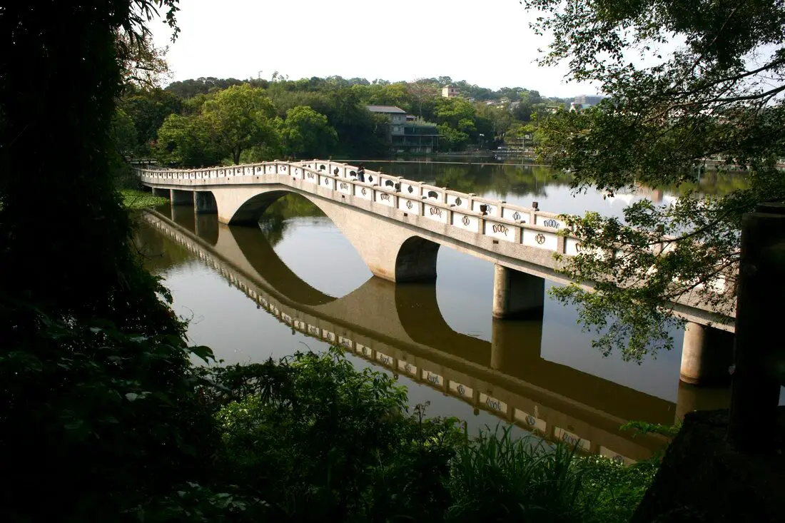
Green Grass Lake is a beautiful pond in southern Hsinchu with a large arched bridge leading to an island park in the middle of the lake. There is also a bike path that goes around the lake. It is a nice place to relax and take a stroll if you are in the area.
Background: Green Grass Lake is actually a small reservoir built along the Keya River in1954. It was meant to provide irrigation, provide flood control, and boost tourism in the area. In 2005, the area around the lake was refurbished and new paths and a bridge were added to the park. Popular activities here include paddle boating, paddle boarding, and cycling. There is also a night market here that opens one day a week on Wednesday. Price: Free Hours: 24/7 Green Grass Lake Night Market 青草湖夜市: Every Wednesday from 6 PM to 11 PM, in front of the elementary school. Tours: You can find more tours and activities in Hsinchu such as You can find more tours and activities in Hsinchu such as river tracing, wild hot springs, white water kayaking, backpack rafting, Little Ding Dong Theme Park, Leofoo Village Theme Park, Window on China Theme Park, glamping, camping, stone spa, horse riding, Yukids Island, Tom and Bei Bei Parent Child Paradise, bee keeping experience, cycling, dried persimmons experience, Jump Wave Trampoline Park and more on Klook here or KKday here. Where to stay: Most of the accommodation you will find is near the city center. If you will only visit downtown, you can consider a day trip from Taipei. We have stayed at and recommend the Golden Motel a high quality motel near Green Grass Lake (you can book on Agoda here, Booking.com here, Hotels.com here, Expedia here, or Trip.com here), and CD Motel, another high quality motel in downtown Hsinchu (you can book on Agoda here, Booking.com here, or Trip.com here). Unfortunately I cannot recommend any further hotels that I have stayed at in Hsinchu because usually we stay at my wife's uncle's house. You can find out where to stay in our Taiwan hotels guide or search for the best hotel deals in Taiwan here. You can also book Wifi and SIM cards for Taiwan on Gigago here. Need travel insurance? Compare prices on Insubuy here. Just to let you know, if you book using the links above, we get some commission at no cost to you, and you can help support our blog. You can click here to receive $5 USD on your first Klook purchase. How to get there: By Car/Scooter: Take highway 117 south from downtown Hsinchu. The lake is up on a hill on Minghu Road Lane 775. If you are looking for car rentals in Hsinchu, you can also search Qeeq here, Klook here, or KKDay here. You can also check out our car rental guide here. Looking for scooter rental in Hsinchu? You can search Klook here or KKday here to look for options. You can also check out our scooter rental guide here. By Bus: You can take bus 5602 to Chiaqiao Station. The ride takes about 19 minutes. You can book tickets to travel to Hsinchu via inter-city bus on Klook here. You can book tickets to Hsinchu via high speed rail (HSR) on Klook here or KKDay here. Book tickets via the normal train (TRA) on Klook here. By Bicycle: Cycling is the best way to enjoy Taiwan's landscapes if you have the time and energy. Looking for bicycle rentals in Taiwan? You can search on KKday here and Klook here. You can also check out our Taiwan cycling guide here. Map: |
Author 作家I am an American expat who has extensive experience living, working, and traveling in Taiwan. In my day, I had to learn many things about Taiwan the hard way. But I have come to learn that Taiwan is one of the best places in the world for Foreigners to live. This blog does not represent the opinions of every foreigner in Taiwan. I am just trying to help others learn more about this beautiful country. Categories
|
 RSS Feed
