

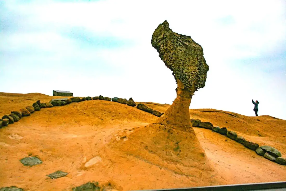
Yehliu is perhaps the most famous geological park in Taiwan, with its most famous landmark being the Queen's Head rock. These rock formations have been forming for thousands of years through erosion of soft sandstone due to wind and water. Hurry and see these formations soon before they are gone forever!
Background: The sandstone that forms the Yehliu formation was created between 10 and 20 million years ago, and was pushed out of the sea along with northern Taiwan thousands of years ago. The Queen's head is formed by two layers of sandstone, one soft fast eroding layer on bottom and a harder layer on top. This kind of sandstone formation can be seen around the world and is known as a hoodoo. The Queen's head was named after Queen Elizabeth I, because it is thought to look like her. The head is eroding .2 to .5 CM per year and is expected to fall at any time! The name Yehliu comes from the Spanish name for the area "Putno Diablos" which was then also used by the Dutch, and transliterated by the Chinese settlers in the area as "Yehliu" in Chinese. Yehliu Ocean world is the largest aquarium in northern Taiwan and has one of the few outdoor sea life amphitheaters in Taiwan. The facility features an indoor aquarium and outdoor show that is geared toward children. Hours: Yehliu Geopark: 8 AM to 5 PM in winter (tickets not sold after 4:30) 8 AM to 6 PM in summer (tickets not sold after 5:30) Yehliu Ocean World: 9 AM to 5 PM Price: Yehliu Geopark: 120 NT per person. You can book discount tickets to Yehliu Geopark on Klook here and KKday here. Yehliu Ocean World: 450 NT per person. You can book discount tickets to Yehliu Ocean World on Klook here and KKday here. You can also book tickets to the Yehliu Ocean World Parent-Child playground on Klook here. Tours: You can book a tour to Yehliu on TripAdvisor here, Klook here, or KKday here. Can I touch the rocks? Don't you dare touch the rocks! Activities along Taiwan's Northern Coast: Don't forget that there are many activities available along Taiwan's Northern Coast such as Wakeboarding, Surfing, Speedboat Surfing, SUP / Paddle Boarding, Diving, Snorkeling Kayaking, Canoeing, Water Biking, River Tracing / Canyoneering, ATVing, Horse Riding, Archery, Tree Climbing, Glamping, Motorcycling, Motorbike Tour, Dragon Boat Racing, Shen'ao Rail Bike, and more on Tripadvisor here, Klook here, or KKday here. Hotels on Taiwan's Northern Coast: We recommend Fullon Hotel which has locations in Tamsui and Fulong near the beach (book on Booking.com here, Tripadvisor here, Agoda here, or Hotels.com here). We have stayed at and recommend Gold Mountain Ranch, which is a horse ranch and glamping destination in Jinshan. You can book a night at Gold Mountain Ranch on Klook here. You can also check out our full blog on the ranch here. We have also stayed at and recommend Hai Xia Your Home which is right in front of Fulong Beach (book on Booking.com here, Tripadvisor here, Agoda here, or Hotels.com here). Looking for a hotel? We recommend booking through Booking.com here, which provides the best quality selection of accommodation in Taiwan. Find out where to stay in our Taiwan hotels guide or search for the best hotel deals in Taiwan here. How to get there: By Bus: There are inter-city buses that leave hourly from Taipei Main Station and Taipei City Hall to Yehliu. You can purchase a discount easy card to use on the MRT and buses from Klook here or KKday here. You can also book an MRT travel pass on Klook here. By Car/Scooter: Take Provincial highway 2 west out of Keelung, and keep going until you reach Wanli. The turnoff to Yehliu comes right after Wanli beach. If you are looking for car rentals, you can also search Qeeq here, Klook here, or KKday here. You can also check out our car rental guide here. Looking for scooter rental in northern Taiwan? You can search on Klook here or KKday here to search for options. You can also check out our scooter rental guide here. By Bicycle: Cycling is the best way to enjoy Taiwan's landscapes if you have the time and energy. Looking for bicycle rentals in Taiwan? You can use Taiwan's many Youbike sharing stations, or search for rentals on KKday here, and search for tours on Klook here. You can also check out our Taiwan cycling guide here. You can also book a cycling tour on TripAdvisor here. For more information, check out our Taiwan transportation guide here. Map: Please see below:
0 Comments
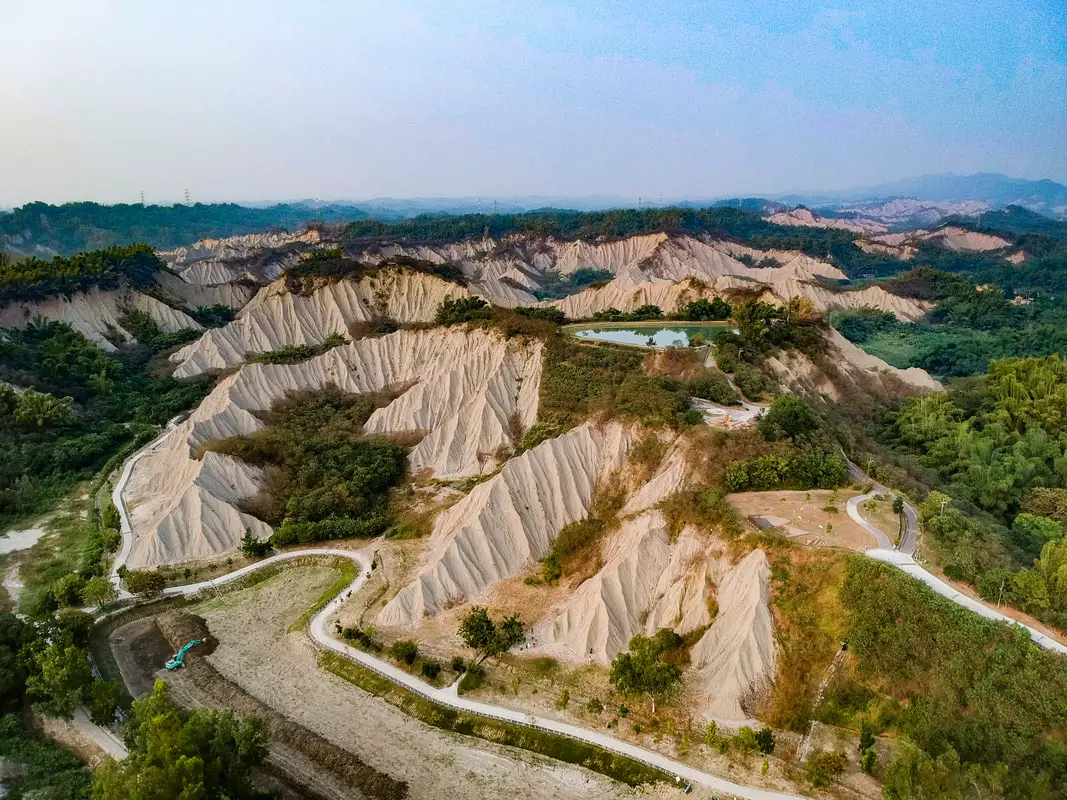
Out in the foothills of former Kaohsiung County are tropical badlands, hills of easily eroding material that makes the landscape look so unique that you must think that it's on the moon. In the summer of 2014 the Foreigners in Taiwan team took a journey to this park in Tianliao which showcases these hills with trails and beautiful scenic views, and 4 years later here is the blog. It's definitely a strange landscape especially for Taiwan, and is worth a visit especially if you want to get some unique photos. You can also see some nearby mud hot springs.
Geological History: Moon World is part of a stretch of badlands that cover a large swath of southern Taiwan near the central mountain range. Typical badlands are found in dryer climates, are composed of sedimentary rocks, typically have very little vegetation, and have deep valleys or ravines. The badlands in Taiwan are unique in that they are in a tropical rain forest. How is this possible? The rocks at Moon World are composed of mudstone, sandstone, shale, and chalk. Because of high alkaline levels due to chalk in the soil, trees and grass cannot grow, and basically the only plant that can grow in the soil is spiny bamboo. The lack of vegetation as well as high rainfall gives way to quick eroding hills, or badlands. The Caoshan River and the Ganglin Rovers also helped to carve out the landscape and bare hills. Because of the white greyish color, the hills seem to glow when in moonlight,hence the name "Moon World." However to the casual observer, the landscape looks like the surface of the moon as well. Hours: All Day. However buses and restaurants will not run all day (there is no 7-11, only round-table chicken quick fry restaurants 土鷄). Price: Free! Accommodation We have stayed at and recommend Chao She Hotel (you can book on Agoda here, Booking.com here, Hotels.com here, or Expedia here) IHI Sanduo Travel Hotel (you can book on Agoda here, Booking.com here, Hotels.com here, or Expedia here), and Mingli Hotel (you can book on Agoda here, Klook here, or Hotels.com here) which are three inexpensive and high quality choices in downtown Kaohsiung. I also have stayed at and recommend Kaohsiung Meinong Rabbit Paul Homestay B&B (you can book on Agoda here, Booking.com here, or Trip.com here), a quiet B&B in rural Meinong, and Chengching Lakeside Resort (you can book on Agoda here, Booking.com or Trip.com here)and the Grand Hotel Kaohsiung (you can book on Agoda here, Booking.com here, Hotels.com here, or Expedia here) which both offer breakfast buffet and free entrance into Chenqing Lake Park. I have also stayed at the 85 sky tower which offers great views of the city; you can search for rooms in the 85 sky tower on Agoda here, Booking.com here, Hotels.com here, Expedia here, or Trip.com here). Find out more about where to stay in our Taiwan hotels guide or search for the best hotel deals in Taiwan here. We recommend booking through Agoda here, which provides the best quality selection of accommodation on the islands. You can also book Wifi and SIM cards for Taiwan on Gigago here. Need travel insurance? Compare prices on Insubuy here. Tours: You can find more tours and activities in Kaohsiung such as Pier 2, Meinong Hakka Museum, Hamasen Railway Museum, Suzuka Circuit Park, i-Ride Kaohsiung Visual 5D Flying Theater, National Science and Technology Museum , Senya Village Restaruant, Austin Land, Ski School Indoor Ski Slope, and many more on Klook here or KKday here. Just to let you know, if you book using the links above, we get some commission at no cost to you, and you can help support our blog. You can click here to receive $5 USD on your first Klook purchase. How to Get There: By Bus: You can either take the Kaohsiung City bus Red 70B from the Gangshan MRT station, or Kbus 8042 from Tainan HSR station. You can book tickets to travel to Kaohsiung via inter-city bus on Klook here. You can book tickets to Kaohsiung via high speed rail (HSR) on Klook here or KKDay here. Book tickets via the normal train (TRA) on Klook here. You can also book a Kaohsiung Travel pass here. By Car/Scooter: Take the Tianliao Exit on National Highway 3 and take provincial highway 28 to Tianliao. Looking for scooter rental in Kaohsiung? You can check out Klook here or KKday here to search for options. You can check also out our scooter rental guide here. If you are looking for car rentals, you can search Qeeq here, KKday here, or Klook here. You can also check out our car rental guide here. Please refer to the map below: 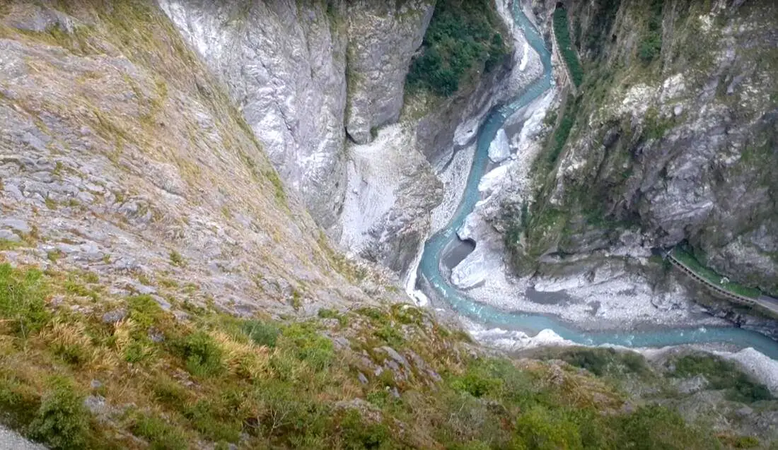
If you only have a few days in Taiwan and you want to go somewhere outside of Taipei, you should definitely go to Taroko National Park. On an island full of mountains, rain forests, beaches, and abounding natural beauty, Taroko might just take the top spot as the most beautiful scenic area in Taiwan.
Taroko National Park is well known for its amazing marble cliffs and canyons carved out by the Liwu River. It is also a popular spot for hiking, rafting, and river tracing. If you have the time, come to the East coast and see it. If you don't have time, then make some time! History and Background: Taroko National Park is well known for its marble cliffs and canyons, and is also known as "The Marble Gorge." Millions of years ago, the rock we see today was sediment at the bottom of the Pacific Ocean, but oceanic and tectonic pressure turned it into limestone, and later into marble. Later the Eurasian plate was uplifted where Taiwan is today, and a gorge was cut out of the limestone thanks to the Liwu River. Taroko means "human being," from the Truku tribal language. Originally the Tupido Tribe settled in the area of what is now Tianxiang Taiti mesa. They built the Tupido Tribe Trail which was only 30 cm wide, and resided there until they were massacred by the Japanese in 1914. In 1917, the Japanese expanded the original trail made by the Tupido Tribe to 1.5 M and forced aboriginal tribesmen to carry goods along the trail to the east coast. This is now the Zhuilu Old Trail. Currently only 3km of the trail is open to the public. The Japanese created a national park in the Area in 1937, which was disestablished by the ROC in 1945, and then reenstated in as a national park in 1986. When to visit? Hualien is great year round, but it can get a little hot in the summer, and Typhoon season and heavy rain season lasts from about May to October. If you are afraid of the heat and rain then you can visit during winter when the temperatures are mild and the climate is usually dryer. Sponsored Links Where to stay? Most of the accommodation you will find is near the city center. If you only want to visit Hualien City and Taroko Gorge, you can consider booking a hotel near downtown, walking or cycling around the city, and taking a bus to Taroko Gorge. We have stayed at and recommend Dream Taiwan Homestay (Agoda / Booking.com / Expedia / Hotels.com), a high quality hostel for the money in downtown Hualien, Farglory Hotel (Agoda / Booking.com / Expedia / Hotels.com), right next to Farglory Ocean Park with amazing views of Hualien, and Goldenflower B&B (Agoda / Booking.com) in Yuli right next to Sixty Stone Mountain. You can find out where to stay in our Taiwan hotels guide or search for the best hotel deals in Taiwan here. How to get there: By Car: From Taipei, Take National Highway 5 to Yilan and then drive on the Suhua Highway 9 to Hualien. A few miles before Hualien City, the gorge will be on your right. By Train: Take the train to Hualien station, and from there you can rent a scooter or car, or take a tour bus to the gorge. For more travel information see here. You can book tickets to travel to Hualien via inter-city bus on Klook here. Book tickets via the normal train (TRA) on Klook here. Need travel insurance? Compare prices on Insubuy here. How to get around in Taroko Gorge: As always, we recommend renting a scooter as the best way to see Taiwan. However, you can also a great deal of Tainan by taking the train, inter-city bus, local bus, biking, or just walking. Getting around in a car is also a convenient option as there is plenty of parking pretty much everywhere in this less crowded county. By Bus: You can book a shuttle bus to Taroko Gorge from Hualien on Klook here. Scooter Rental: Looking for scooter rental in Hualien? You can search KKday here or Klook here to look for options. You can also check out our scooter rental guide here. Car Rental: If you are looking for car rentals in Hualien, you can also search Klook here or KKDay here. You can also check out our car rental guide here. Tours: You can find more tours and activities in Hualien such as Surfing, Paragliding, SUP / Paddle Boarding, Kayaking, Canoeing, River Tracing, River Rafting, Whale Watching, Snorkeling, Diving, ATV / 4-wheeling, Paintballing, Farm Dream Estates Zoo, Water Biking, Oyster Harvesting, Shrimp Harvesting, Indigenous Experience, Glamping, Cycling, Ziplining and much more on Klook here or KKday here. You can also book Wifi and SIM cards for Taiwan on Gigago here. Just to let you know, if you book using the links above, we get some commission at no cost to you, and you can help support our blog. You can click here to receive $5 USD on your first Klook purchase. Hours: 8:30AM-5PM (Zhuilu old trail is open from 7AM to 10PM). Flying a Drone? Apply for a drone permit here. Price: Free! (Except Zhuilu old trail, which is 200 NT per adult. See below for more info.) Map: Please see below: 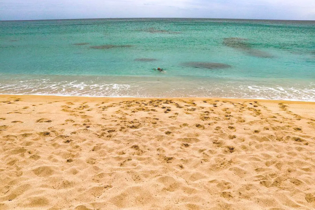
Yes, you should go to Kenting. Kenting has some of the best natural scenery in Taiwan, from beautiful white sand beaches that are warm year round to limestone mountains with hundreds of caves and waterfalls to explore. Although it may not be a world class beach resort destination yet, it should definitely be on your list on your trip to Taiwan.
Historical Background: The area around the Hengchun Peninsula was once coral that has been uplifted over millions of years. The first people to live here were Taiwan aboriginals, from the Paiwan and Puyuma tribes (who caused the Rover Incident as portrayed in Seqalu: Formosa 1867). Kenting was first settled by Han farmers and fishermen during the Qing Dynasty. The word Kenting comes from two words that mean cultivate (ken3 墾) and strong man (丁 ding1). During that time, a group of strong men (or Zhuang Ding 壯丁) came from Guangdong, who were basically Chinese pioneers of the area to cultivate the land, hence the area was named Kenting for them. The aboriginal people were mostly assimilated with the local Chinese population. The area was considered to be made into a park during the Japanese occupation due to it being the only tropical location in the Japanese Empire, but was never officially created. During the Japanese era, Nanwan was used as a whaling area and there were a few fishing villages here. The Whaling industry continued here in the ROC era until the international ban on whaling in 1986. Kenting National Park was established in 1984 as the first national park in Taiwan after WWII. Kenting became a major vacation spot, becoming a center for hostels and hotels for travelers. Kenting is considered by many to have the best beaches in Taiwan. This is because of its fine white sand and year-round warm temperatures and sunshine (it is in the tropical part of Taiwan after all). When to go: Summer is the best time to go because there is warm sunny weather and not a lot of wind. However, there are more people and there may be Typhoons. Winters are windy and colder, but the water is still warm enough to swim in. Winter is a better time for activities like hiking and surfing. How to get there: By Car/Scooter: Take provincial highway 1 south to the bottom of Taiwan until it becomes provincial highway 26. After that keep going past Hengchun into Kenting National Park. Looking for scooter rental in Kenting? Click here or here to search for options. If you are looking for car rentals, you can also search Qeeq here, Klook here, or KKday here. You can also check out our car rental guide here. By Bus: Busses leave daily to Kenting from Zuoying HSR station, Kaohsiung Station, and Pingtung. You can book tickets to Kenting via high speed rail (HSR) on Klook here or KKDay here, or book tickets via the normal train (TRA) on Klook here. You can book tickets to travel to Kenting via inter-city bus on Klook here. Once in Kenting, you can save money by booking Kenting's bus pass. By Plane: There are direct shuttle busses to Kenting from Kaohsing's Xiaogang (KHH) Airport. You can search for cheap flights in Taiwan here. By Bicycle: Cycling is the best way to enjoy Taiwan's landscapes if you have the time and energy. Looking for bicycle rentals in Taiwan? You can search on KKday here and search for tours on Klook here. You can also check out our Taiwan cycling guide here. Where to stay: Looking for a hotel? Find out where to stay in our Taiwan hotels guide or search for the best hotel deals in Taiwan here. We recommend booking through Agoda here, which provides the best quality selection of accommodation in Taiwan. I have stayed at many hostels and hotels in Pingtung, and even almost bought a house here. Some places that I have stayed at and can recommend are Nanwan Kiki (book on Agoda here or Booking.com here), a B&B next to Nanwan Bay, Kenting's most popular Beach. There are also a few decent hotels near Kenting Street Night Market like Kenting Star Inn 888 (book on Agoda here, Klook here, or Booking.com here), or Kenting Dajianshan Hotel (book on Agoda here or Booking.com here). You will notice that none of these hotels are five star resorts (I do not come to Kenting to waste my time at a resort, but you can still search Agoda, Booking.com, or Klook here for those) but they are in my opinion the above have the best value for the money. How to get around in Kenting: 1. Rent a scooter - the best way to see Taiwan. Electric scooters that do not require a license are also readily available. For better range and speed, rent a gas scooter. You can search for scooter options here or here, and you can check out our scooter rental guide here. 2. Rent a car - more expensive than a scooter but may be more suitable for a large family. If you are looking for car rentals, you can also search Qeeq here, Klook here, or KKday here. You can also check out our car rental guide here. 3. Take the Kenting bus - cheap but slower than your own transportation, and it doesn't stop everywhere. You can book tickets to travel to Kenting via inter-city bus on Klook here. 4. Cycle - you can rent a bicycle or bring your own. This is a great way to enjoy the scenery at a slower pace. You can search on KKday here and search for tours on Klook here. You can also check out our Taiwan cycling guide here. 5. Hire a taxi - more expensive than a rental car but perhaps more convenient. You can also search for a car charter service here or here. Tours and Activities in Kenting: There are many activities available in Kenting, such as snorkeling, diving, SUPing, surfing, submarine riding, and river tracing. You can find more tours of Kenting on Klook here or KKday here. Just to let you know, if you book using the links above, we get some commission at no cost to you, and you can help support our blog. You can click here to receive $5 USD on your first Klook purchase. Places we will cover in this blog:
Map of sites in this blog: 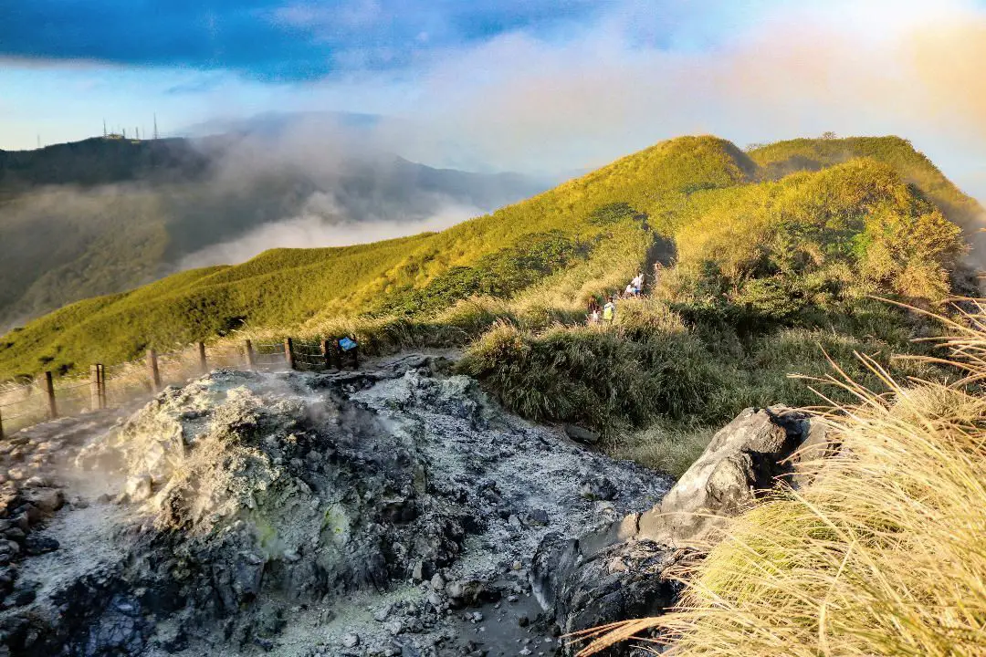
Yangmingshan National Park is a mountainous area in Taipei and New Taipei, known for its volcanic activity, hiking trails, wildlife, waterfalls, hot springs, and sulfur vents. It is definitely worth a stop on your trip to Taipei.
Historical Background: The area known as Yangmingshan now was formed by volcanoes about 700,000 years ago, forming many mountains about 1000 meters or less in northwestern Taiwan. The park still features active volcanoes, vents, and hot springs. The original name of the area was Caoshan (grass mountain 草山). During the Qing Dynasty, the area was used to harvest sulfur, and many of the hills were burned to help catch sulfur thieves, Qingtiangang likely being one of these areas. Sulfur mining was started in the Qing Dynasty by a British mining company that first obtained the rights to mine here in 1897. In 1927 during the Japanese era, Yangmingshan was made as the first national park in Taiwan, then known as Datunshan National Park Association. The area around Qingtiangang to Lengshuikeng was made into a ranch for water buffalo, and grass from Japan was planted here for them to graze. In 1950 after the ROC took Taiwan, Chiang Kai-shek renamed the park after the philosopher Wang Yangming, and called the area Yangmingshan. The KMT kept the ranch at Qingtiangang and continued to maintain it. They also built bunkers here and kept a garrison of troops. In 1985, after resolving many land disputes, Yangmingshan National Park was officially designated as a national park in the ROC era. Due to its easy accessibility from Taipei and many natural attractions, it is one of the most popular tourist destinations in Taipei City. Most visitors come on weekends, and it has parking lots and visitor's centers throughout the park. Hours: The visitor's centers are open from 9 AM to 4:30 PM. However you can visit the park 24/7. Price: Free entrance into the park (car parking 30-50 NT, scooter parking 20 NT) You can book tours to Yangmingshan on TripAdvisor here, Klook here, or KKday here or here. Tours: You can check out tours to Yangmingshan such as a One-day Yangmingshan NP Beitou Hot Spring Park and Tamsui Tour Package, Beitou and Yangmingshan Day Tour from Taipei, One Day Hike around Yangmingshan, or Private Yangmingshan Volcano Tour and more on TripAdvisor here, Klook here, or KKday here. When to Go: Silver Grass Season: Mang Grass season goes from September to November. During this time you will be able to see silvery grass all over the mountain tops around the park. Cherry Blossom Season: Cherry blossoms can be seen in the park from February to late March. Snowfall: Once every few years it can snow here from December to February. The snow usually only lasts a day or two and melts away quickly. Best Weather: In my opinion, the best weather is in the summer when constant rain makes the air cleaner, and summer mornings are usually clear. Be sure to start hiking in the morning for the best views and sunshine, as afternoon thundershowers are common. Hotels in Taipei: High end: We have stayed at and recommend the Yuanshan Grand Hotel, once the tallest building in Taiwan and still the most grand (book on Booking.com here, Tripadvisor here, or Agoda here). We have also stayed at and recommend the Grand Hyatt (book on Booking.com here, Tripadvisor here, Agoda here, or Hotels.com here), Marriot (book on Booking.com here, Tripadvisor here, Agoda here, or Hotels.com here), Sheraton (book on Booking.com here, Tripadvisor here, Agoda here, or Hotels.com here), Shangri-la (book on Booking.com here, Tripadvisor here, Agoda here, or Hotels.com here), and Regent (book on Booking.com here, Tripadvisor here, Agoda here, or Hotels.com here), which are all very high quality hotels in the middle of Taipei City. We also recommend Fullon Hotel which has locations in Tamsui and Fulong near the beach (book on Booking.com here, Tripadvisor here, Agoda here, or Hotels.com here). Budget Hotels: We have stayed at and also recommend Fu Chang Hotel in Ximending, which is within walking distance of Ximending shopping district (book on Booking.com here, Tripadvisor here, or Agoda here). We have also stayed at and recommend Hai Xia Your Home which is right in front of Fulong Beach (book on Booking.com here, Tripadvisor here, Agoda here, or Hotels.com here). Looking for a hotel? We recommend booking through Booking.com here, which provides the best quality selection of accommodation in Taiwan. Find out where to stay in our Taiwan hotels guide or search for the best hotel deals in Taiwan here. How to get there: By Car/Scooter: From Taipei, take provincial highway 2A north to the park, where you can see the main attractions such as Zhuzihu, Qixingshan, Datunshan, Qingtiangang, etc. There are many parking lots, but car parking is limited on weekends and the number of cars allowed up the mountain is also limited. There is also paid scooter parking. On weekends this place can be packed, and cars can be backed up for up to an hour or more, so consider taking a scooter or bus. Looking for scooter rental in Taipei? Check out Qeeq here, Klook here, or KKday here to search for options. You can also check out our scooter rental guide here. If you are looking for car rentals, you can also search Qeeq here, Klook here, or KKday here. You can also check out our car rental guide here. By Bus: From Beitou MRT Station, Take Little Bus 19 (小19), or another bus to the park. You can book tickets to travel to Taipei via inter-city bus on Klook here. You can book tickets to Taipei via high speed rail (HSR) on Klook here or KKDay here. By Bicycle: Cycling is the best way to enjoy Taiwan's landscapes if you have the time and energy. Looking for bicycle rentals in Taiwan? You can search on KKday here and search for tours on Klook here. You can also check out our Taiwan cycling guide here. Map: See below for a map of places mentioned in this blog: 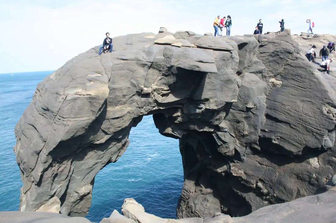
Elephant Trunk Rock was a rock shaped like its name in the Shenao area of Ruifang District, New Taipei City. There are also many interesting rock formations in the area. It was one of the most recognizable rock formations on the north coast and a popular location for, kayakers, snorkelers, and Instagrammers.
Elephant Trunk Rock eroded away and fell into the sea on December 16th, 2023. You can still visit for great views here, but the elephant trunk is gone. Background: The sandstone and sedimentary that forms the Elephant Rock formation was created between 10 and 20 million years ago, and was pushed out of the sea along with northern Taiwan thousands of years ago. The Elephant's head was formed by easily eroding sandstone, with the area under the trunk being eroded away by the sea and waves. Elephant Rock is so named because it looks like an elephant. The area around Elephant Rock was a protected military base until the year 2000, after which civilians were allowed to freely visit. Kayaking and Snorkeling are also popular activities near the Elephant Rock. Hours: 24/7 Price: Free Tours and Activities: At Elephant Rock there are many activities available to enjoy such as kayaking, canoeing, snorkeling, SUP / paddle boarding, water biking, and more activities which you can book on Klook here or KKday here. Hotels on Taiwan's Northern Coast: We recommend Fullon Hotel which has locations in Tamsui and Fulong near the beach (book on Booking.com here, Tripadvisor here, Agoda here, or Hotels.com here). We have stayed at and recommend Gold Mountain Ranch, which is a horse ranch and glamping destination in Jinshan. You can book a night at Gold Mountain Ranch on Klook here. You can also check out our full blog on the ranch here. We have also stayed at and recommend Hai Xia Your Home which is right in front of Fulong Beach (book on Booking.com here, Tripadvisor here, Agoda here, or Hotels.com here). Looking for a hotel? We recommend booking through Booking.com here, which provides the best quality selection of accommodation in Taiwan. Find out where to stay in our Taiwan hotels guide or search for the best hotel deals in Taiwan here. How to get there: By Car/Scooter: Drive to Keelung, then from downtown take provincial highway 2 east about 10 KM until you reach the Shenziao harbor, and there is some paid parking if you drive to the very end, which will put you closest to Elephant Trunk Rock. If you are looking for car rentals, you can also search Qeeq here, Klook here, or KKday here. You can also check out our car rental guide here. Looking for scooter rental in northern Taiwan? You can search on Klook here or KKday here to search for options. You can also check out our scooter rental guide here. By Train/Bus: Take the TRA to Badouzi (八斗子) station, then walk about 1 KM east until you reach the elephant rock on the coast. Book tickets via the normal train (TRA) on Klook here. You can purchase a discount easy card to use on the MRT and buses from Klook here or KKday here. You can also book an MRT travel pass on Klook here. By Bicycle: Cycling is the best way to enjoy Taiwan's landscapes if you have the time and energy. Looking for bicycle rentals in Taiwan? You can use Taiwan's many Youbike sharing stations, or search for rentals on KKday here, and search for tours on Klook here. You can also check out our Taiwan cycling guide here. You can also book a cycling tour on TripAdvisor here. For more information, check out our Taiwan transportation guide here. Map: Please see below: 
For such a small island, Taiwan's geography is varied and complex. From lowland plains to alpine peaks, to badlands, volcanoes, tropical rainforests, and more, there are some amazing landscapes here to explore.
Basic Taiwan Travel Tips:
Hotels in Taiwan: Looking for a hotel? We recommend booking through Booking.com here, which provides the best quality selection of accommodation in Taiwan. Find out where to stay in our Taiwan hotels guide or search for the best hotel deals in Taiwan here. Tours in Taiwan: There are many tour itineraries that you can enjoy in Taipei that will take you to multiple destinations and arrange transportation. For more information, you can check out Tripadvisor here, KKday here or Klook here, which are both great tour websites that can connect you with the right tour and tour guide for you. Here are some of the most popular tours of Taiwan on TripAdvisor:
What is the best way to get around Taiwan? I personally think the best way to get around is by Scooter, but bicycle and public transport are also very good. Travelling by car is difficult because there are narrow streets, many scooters, and limited parking. You have a few options: For more information, please visit our travel/transportation FAQ. Taiwan's transportation system is convenient and safe. There are many options you can consider to get around in Taipei below: By Train: Gets you to the city center of all major cities in Taiwan. It is about 800NT to get from Taipei to Kaohsiung. Roughly half the price of the HSR. Book tickets via the normal train (TRA) on Klook here. By HSR: (High-Speed Rail) – Gets you quickly from north to south. Besides Taipei and Kaohsiung, most of the stations are far from city centers. It costs about 1500NT to get from Taipei to Kaohsiung. You can book tickets to the high-speed rail (HSR) on Klook here or KKDay here. By MRT: (Mass Rapid Transit, Metro train, subway) – Easily gets you around Taipei and Kaohsiung. You can purchase a discount easy card to use on the MRT from Klook here or KKday here. You can also book an MRT travel pass on Klook here. By Bus: Buses can be tricky. Long-range buses such as Ubus and King Bus are easier to understand and cheaper than the local train. They can take you to the city center of every city throughout Taiwan and to remote tourist destinations such as sun moon lake. A long-range bus from Taipei to Kaohsiung is about 500 NT. You can also book tickets to travel to Shifen via inter-city bus on Klook here. You can also book a Taipei Sightseeing: Hop On, Hop Off Open Top Bus on TripAdvisor here. By Taxi: You can take short rides for about 150 NT, or hire a Taxi for a day for around 150 USD. By Car: If you are looking for car rentals, you can also search Qeeq here, Klook here, or KKday here. You can also check out our car rental guide here. By Scooter: Looking for scooter rental in Taipei? You can search on Klook here or KKday here to search for options. You can also check out our scooter rental guide here. By Bicycle: Cycling is the best way to enjoy Taiwan's landscapes if you have the time and energy. Looking for bicycle rentals in Taiwan? You can use Taiwan's many Youbike sharing stations, or search for rentals on KKday here, and search for tours on Klook here. You can also check out our Taiwan cycling guide here. ​You can also book a Sunset Riverside Bike Ride and Historical Tour, 4 Hour Cycling in Taipei, Ultimate 8-Hour Cycling City Tour, or Taipei City Bike Tour with Night Market Experience on TripAdvisor here. For more information, check out our Taiwan transportation guide here. How many seasons does Taiwan have? Four. They are most pronounced up north and lees distinguishable in the south. Is Taiwan in Asia? Yes. In fact, Taiwan is the heart of Asia! Where is Taiwan on a map? Taiwan is in the heart of Asia!
Why is Taiwan the heart of Asia?
From a purely geographical perspective, Taiwan lies in a central location in East Asia, between China, Kong Kong, Macau, Japan, Korea, and is also close to the Philipines, and other southeat Asian countries, making it a prime spot for an Asian hub. Taiwan also is highly influenced culturally by other East Asian nations, such as China, Japan, and Korea. When does Taiwan change time? It does not. There is no daylight savings time in Taiwan as of now. What is the capital of Taiwan? Taipei. What time Zone is Taiwan in? China Standard Time (CST) or UTC+08:00. What time is it in Taipei? Check this link. What year does Taiwan use? The official years are counted from the founding of the government of Taiwan, the Republic of China (ROC). For 2018, this will be year 107, 107 years from the start of the ROC in 1911. However, the western calendar is used for almost all non-government dates and is acceptable. How do you write the date in Taiwan? Year, month, day. Use the ROC year if you are writing a government form or document. What is the population of Taipei? 2,704,974 as of 2016. Why does Taiwan have a high population density? Taiwan has a population of more than 23 million people, while the flat land in Taiwan only accounts for 1/3 of the island mainly on the west side, meaning that most people live in cities on the west coast. This means that Taiwan’s cities are very densely populated. Why does Taiwan have the lowest birth rate? Taiwan has had the lowest birth rate, and one of the lowest birth rates every year due to a number of factors, one being high cost of raising a child vs. low average incomes. Many couples in Taiwan both work, so raising a child means extra fees like nannies, daycare, and cram school. Also, there is cultural pressure for couples to be financially stable before they get married, such as owning a house, which put the age for marriage and childbearing later and later. Why does Taiwan have the lowest poverty rate? This is due mainly to the Taiwan government’s social welfare and subsidies for low income families. For more information, click here. How Many Islands does Taiwan have? 45! We counted. But there are many other offshore rocks, as well as disputed territory claimed by the ROC but controlled by other countries. If you don' count the islands in the South China Sea, Taiwan only has only 41 islands. If you don't count Matsu, Kinmen, and the South China Sea, then Taiwan only has 23 islands. For more information, click here. How many cities does Taiwan have? 23. For a full list of cities, click here. What is the highest point in Taiwan? The highest mountain in Taiwan is Mt. Jade or Yushan (玉山), which is 3952 meters high (12,966 feet), making Taiwan the 4th highest island in the world and highest point in East Asia. Click here for our blog of our summit of this mountain. Are there elephants in Taiwan? Not in the wild, just at the zoo. Are there monkeys in Taiwan? Yes. The only monkeys native to Taiwan are the Formosan Rock Macaque. You can find them in most mountainous areas in Taiwan, but please do not feed them for your safety as well as for the monkey’s well being. Are there tigers in Taiwan? Not in the wild, just at the zoo. The Formosan clouded leopard is also believed to be extinct. Are there sharks in Taiwan? Yes. But in the past 118 years, there has only been 6 shark attacks, and only 2 of those were fatal, so you should feel safe from sharks when your are swimming and surfing at the beach. However, there are still other dangers at the beach, such as sharp rocks, rip tides, and bad weather. Are there pandas in Taiwan? Not in the wild, just at the zoo. Are there crocodiles in Taiwan? Not in the wild, just at the zoo. Click here to see saltwater crocodile distribution. Are there beaches in Taiwan? Yes. Taiwan has 1,239.5756 km (770.2366 mi) of coastline and countless beaches. Click here for the best beaches in New Taipei. Are there volcanoes in Taiwan? Yes. There are 9 volcanoes in Taiwan. Are volcanoes in Taiwan dangerous? There is a very very small chance that they are dangerous. The Tatun volcano group which lay 15km northwest of Taipei are active, although the chance of an eruption any time soon is very low. Are there Typhoons in Taiwan? Yes. When is Typhoon Season in Taiwan? Typhoon Season is roughly from July to October. Are Typhoons in Taiwan dangerous? No. Usually casualties come from people being outside or from rock slides and flooding. Most all buildings in Taiwan are Typhoon-proof, so as long as you stay indoors during a typhoon you should be safe. Where was the earthquake in Taiwan? The 921 earthquake was centered in Jiji, Nantou on September 21st, 1999, killing 2,415 people. It was the worst earthquake in Taiwan in recent history. For more recent earthquakes, check here. Why does Taiwan have earthquakes? This is because of collisions between the Eurasian plate and the Philippian Sea Plate. Taiwan also lies on the Pacific ring of fire. For more information, click here. How often does Taiwan have earthquakes? Daily. However, major earthquakes are rare. For more recent earthquakes, check here. What is the weather like in Taiwan? Please see our Taiwan weather FAQ here. What is New Taipei City? New Taipei city is the area surrounding Taipei city, and was formerly known as Taipei county. Where is Taipei on a Map? Taipei City is located in northern Taiwan, laying in the middle of the Taipei Basin surrounded by New Taipei City. Please refer to the map below:
Where is New Taipei City? New Taipei City (formerly Taipei County), is located in northern Taiwan, surrounding Taipei City. Please refer to the map below:
Where is Yilan in Taiwan? Yilan lies on the Northeast Coast of Taiwan. Please refer to the map below:
Where is Alishan in Taiwan? Alishan lies in the mountains of South-Central Taiwan. The quickest way to get there is through Chiayi City. Where is Jiufen in Taiwan? Jiufen is a city that sits on a hill in northern New Taipei City. It can be reached by bus from Taipei. Where is Hualien in Taiwan? Hualien lies on Taiwan’s east central coast. It is the gateway to Taroko national park. Where is Kenting in Taiwan? Kenting lies on the southern tip of Taiwan. It has some of the warmest weather and best beaches in Taiwan. Where is Jade Mountain (Yushan) in Taiwan? Jade Mountain lies in the mountains of South-Central Taiwan. The only way to get there is by bus or by your own vehicle. Click here for our blog of our summit of this mountain. Please refer to the map below: Attractions in Taiwan: There are many attractions that you can enjoy in Taipei such as Taipei 101 Observatory, Taipei 101 460 Skyline Observatory, Taipei Children's Amusement Park, Maokong Gondola, National Palace Museum, Yehliu Ocean World, Yehliu Geopark, National Museum of Marine Science and Biology, i-ride 5D cinema, Astronomical Museum, Miniatures Museum of Taiwan, Double Decker Sightseeing Bus, Miramar Ferris Wheel Ticket, Taipei Zoo, Heping Island Park, Ju Ming Museum, Yuanshan Hotel Secret Road, National Taiwan Museum, New Taipei Gold Museum, Futian Leisure Farm, Chiang Kai-shek Shilin Residence, Chi Po-lin Museaum, Beitou Museum, Tsao Wonderland, Railway Museum, Fort San Domingo, 13 Levels Archaeology Museum, Austin Land, Museum of World Religions, Formosan Aboriginies Museum, ASE Parent-child Park, teamLab Future Park, Yukids Island, VR Experience, Bat Cave, Neidong Waterfall, Candlestick Islet, Jurassic Snow Park, Zhonghe High5 Amusement Park, Longshan Temple, Xingtian Temple, Ningxia Night Market, Yansan Night Market, Meteor Garden, Yingge Old Street, and many more attractions on Tripadvisor here, Klook here, or KKday here. Activities in Taiwan: Don't forget that there are many activities available in Taipei such as Indoor Skiing, Rock Climbing, Hiking, Wakeboarding, Surfing, Speedboat Surfing, SUP / Paddle Boarding, Diving, Snorkeling Kayaking, Canoeing, Water Biking, River Tracing / Canyoneering, ATVing, Horse Riding, Cooking Class, Archery, Ice Skating, Roller Skating, Tree Climbing, Urban Camping, Glamping, Motorcycling, Motorbike Tour, Dragon Boat Racing, Escape Room, Shen'ao Rail Bike, Laser Gun Experience, Batting Cages, Bowling, Paintball, Flight Simulation Experience, Taipei Tram Driving Experience, Rail Simulation Experience, Taipei 101 Observation Deck activity, Strawberry Picking, Professional Photo Shoot, Body Relaxation SPA, Night Tour, Calligraphy Workshop, and more on Tripadvisor here, Klook here, or KKday here. Have any more questions about the geography of Taiwan? Please leave them in the comments below, and we might just add them to the list! Please like, follow, and share to help everyone know that Taiwan is a great place to vacation year round! You can also check out our full travel guide to Taiwan here. 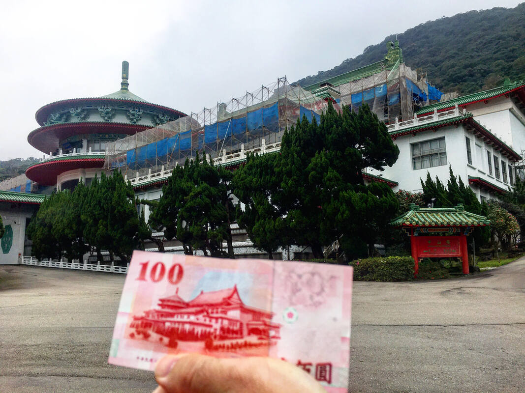
You may recognize the Chungshan Building from the back of the 100 NT dollar bill. Originally built as a meeting place for the now defunct National Assembly, the building is now rarely used for events. The fact that is the only building in the world built right on top of a sulfur vent means that it is hard to maintain, and many parts of the building are under constant repair. However it is full of precocious art and beautiful architecture, and it is open daily for tours.
Background: The land that the Chunghsan Building Currently rests on an active sulfur vent, formerly known as the Caoshan Hot Springs. During the Japanese era, this place was home to an elementary school and was the source of hot spring water for local hot spring hotels (and still is). After the KMT took Taiwan, the reason this location was chosen by Chiang Kai-shek for a government building was because of the locations remarkable Fengshui. The location aligns perfectly with nearby mountains and valleys to create the perfect stream for Fenshui to flow. The Chungshan Building started construction in October 1965 and was completed in November 1966, with construction time totaling only 13 months. This was due to planning from the architect Ms. Xiu Zelan (修澤蘭) and the backbreaking nonstop labor from the KMT military, which would be sure to break all labor laws today. Another reason for the speedy completion was that it was needed to be ready to commemorate the 100th birthday of the father of the ROC, Sun Yat-sen. In order to cope with the constant sulfur vents steaming out of the mountain, the building is equipped with giant exhaust pipes that go through the center of the building. This also helps to keep the building warm in winter. The foundations of the building go down 12 meters into the sulfur soil, and are coated with tar and aluminum to prevent corrosion. Also, much of the building is plated with pure gold to prevent corrosion. This is the only building in the world built on top of a sulfur vent. The building was meant to be the place for the National Assembly to meet, and also a place to show off the elegance of China to foreign dignitaries. Taiwan was thrown out of the U.N. in 1971, after which many fewer foreign heads of state visited Taiwan. The National Assembly was established in 1948 to elect the president of the Republic of China. Its power was then granted to the legislative Yuan and the Taiwanese people in the 1990s, in the wake of free elections in Taiwan, and it was officially disbanded in 2005, meaning the building no longer served any real purpose. Also in 2005, it was declared a national historical monument. The assembly hall as capacity for 1800 people and the cafeteria has room for 2000 people. Besides paid tours daily, sometimes presidential events and art exhibitions are held here. Price: 80 NT You can book a private tour to the Chungshan building on Klook here. Tours: You can book a private tour to the Chungshan building on Klook here. You can check out tours to Yangmingshan such as a One-day Yangmingshan NP Beitou Hot Spring Park and Tamsui Tour Package, Beitou and Yangmingshan Day Tour from Taipei, One Day Hike around Yangmingshan, or Private Yangmingshan Volcano Tour and more on TripAdvisor here, Klook here, or KKday here. Hours: Tour times are 9:00 AM, 10:30 AM, 1:30 PM, and 3 PM daily and the tour lasts about an hour and a half. I highly recommend it. Be sure to get there about 10 minutes early. Be wary that for some national holidays the building is closed to the public. Hotels in Taipei: High end: We have stayed at and recommend the Yuanshan Grand Hotel, once the tallest building in Taiwan and still the most grand (book on Booking.com here, Tripadvisor here, or Agoda here). We also recommend Fullon Hotel which has locations in Tamsui and Fulong near the beach (book on Booking.com here, Tripadvisor here, Agoda here, or Hotels.com here). Budget Hotels: We have stayed at and also recommend Fu Chang Hotel in Ximending, which is within walking distance of Ximending shopping district (book on Booking.com here, Tripadvisor here, or Agoda here). We have also stayed at and recommend Hai Xia Your Home which is right in front of Fulong Beach (book on Booking.com here, Tripadvisor here, Agoda here, or Hotels.com here). Looking for a hotel? We recommend booking through Booking.com here, which provides the best quality selection of accommodation in Taiwan. Find out where to stay in our Taiwan hotels guide or search for the best hotel deals in Taiwan here. How to Get There: By Bus: Take bus 260 from Shilin Station. The bus ride to the Chungshan Station stop takes about an hour. You can book tickets to travel to Taipei via inter-city bus on Klook here. By Car/Scooter: Drive up provincial Highway 2A up into Yangmingshan National Park. The building sits at the intersection between Highway 2A and Yangjin Highway. There is free parking in front of the building. Looking for scooter rental in Taipei? Check out Qeeq here, Klook here, or KKday here to search for options. You can also check out our scooter rental guide here. If you are looking for car rentals, you can also search Qeeq here, Klook here, or KKday here. You can also check out our car rental guide here. By Bicycle: Cycling is the best way to enjoy Taiwan's landscapes if you have the time and energy. Looking for bicycle rentals in Taiwan? You can use Taiwan's many Youbike sharing stations, or search for rentals on KKday here, and search for tours on Klook here. You can also check out our Taiwan cycling guide here. ​You can also book a Sunset Riverside Bike Ride and Historical Tour, 4 Hour Cycling in Taipei, Ultimate 8-Hour Cycling City Tour, or Taipei City Bike Tour with Night Market Experience on TripAdvisor here. Map: Please see below: 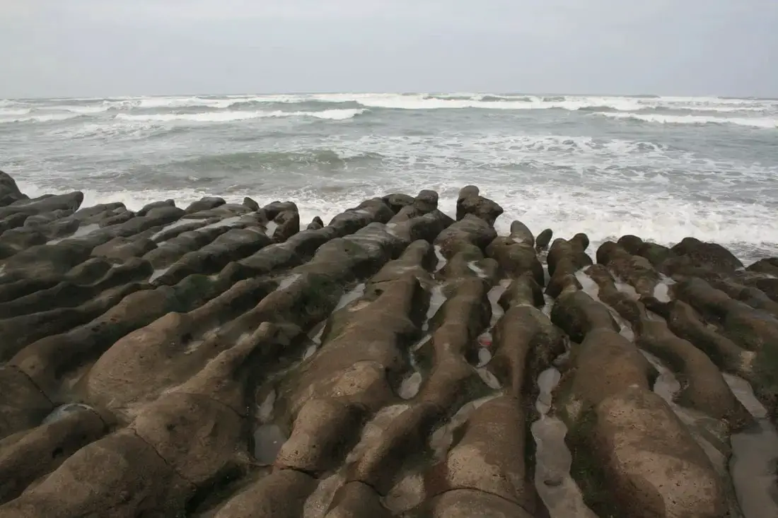
Laomei Green Reef is a popular tourist destination just a kilometer away up the coast from Baishawan, past Fugui Cape. If you catch the reef at a super low tide, the rocks will be covered in green algae.
Background: Laomei Green Reef was formed roughly 800,000 years ago by volcanoes spewing lava into the ocean creating Fuigui Cape. Later, Alagae began growing on the rocks. Now at low tide, the rocks look like they are a "green reef," hence their name. Because of its proximity to Taipei, there are sure to be many visitors, and because Taipei has the highest concentration of foreigners, be prepared to see a lot of other foreigners as well. Price: Free Parking: Free. There is a parking lot in front of the main entrance. If this is full, you can park along the road next to it. Tours: You can book a Private Laomei Green Reef Day Tour from Taipei on TripAdvisor here or KKday here. You can book a tour to Taiwan's North Coast on TripAdvisor here, Klook here, or KKday here. Activities: Don't forget that there are many activities available along Taiwan's Northern Coast such as Wakeboarding, Surfing, Speedboat Surfing, SUP / Paddle Boarding, Diving, Snorkeling Kayaking, Canoeing, Water Biking, River Tracing / Canyoneering, ATVing, Horse Riding, Archery, Tree Climbing, Glamping, Motorcycling, Motorbike Tour, Dragon Boat Racing, Shen'ao Rail Bike, and more on Tripadvisor here, Klook here, or KKday here. Hotels on Taiwan's Northern Coast: We recommend Fullon Hotel which has locations in Tamsui and Fulong near the beach (book on Booking.com here, Tripadvisor here, Agoda here, or Hotels.com here). We have also stayed at and recommend Hai Xia Your Home which is right in front of Fulong Beach (book on Booking.com here, Tripadvisor here, Agoda here, or Hotels.com here). Looking for a hotel? We recommend booking through Booking.com here, which provides the best quality selection of accommodation in Taiwan. Find out where to stay in our Taiwan hotels guide or search for the best hotel deals in Taiwan here. How to Get There: By Bus: Take Keelung bus from either Danshui MRT station or Keelung TRA station. You can also take the yellow and white North Coast Shuttle Bus to Baishawan station. You can purchase a discount easy card to use on the MRT and buses from Klook here or KKday here. You can also book an MRT travel pass on Klook here. By Car/Scooter: Drive on Provincial Highway 2 out of Danshui to the northeast, or out of Keelung to the northwest. The beach area is near Sanzhi District 三芝區. If you are looking for car rentals, you can also search Qeeq here, Klook here, or KKday here. You can also check out our car rental guide here. Looking for scooter rental in northern Taiwan? You can search on Klook here or KKday here to search for options. You can also check out our scooter rental guide here. By Bicycle: Cycling is the best way to enjoy Taiwan's landscapes if you have the time and energy. Looking for bicycle rentals in Taiwan? You can use Taiwan's many Youbike sharing stations, or search for rentals on KKday here, and search for tours on Klook here. You can also check out our Taiwan cycling guide here. You can also book a cycling tour on TripAdvisor here. For more information, check out our Taiwan transportation guide here. Map: 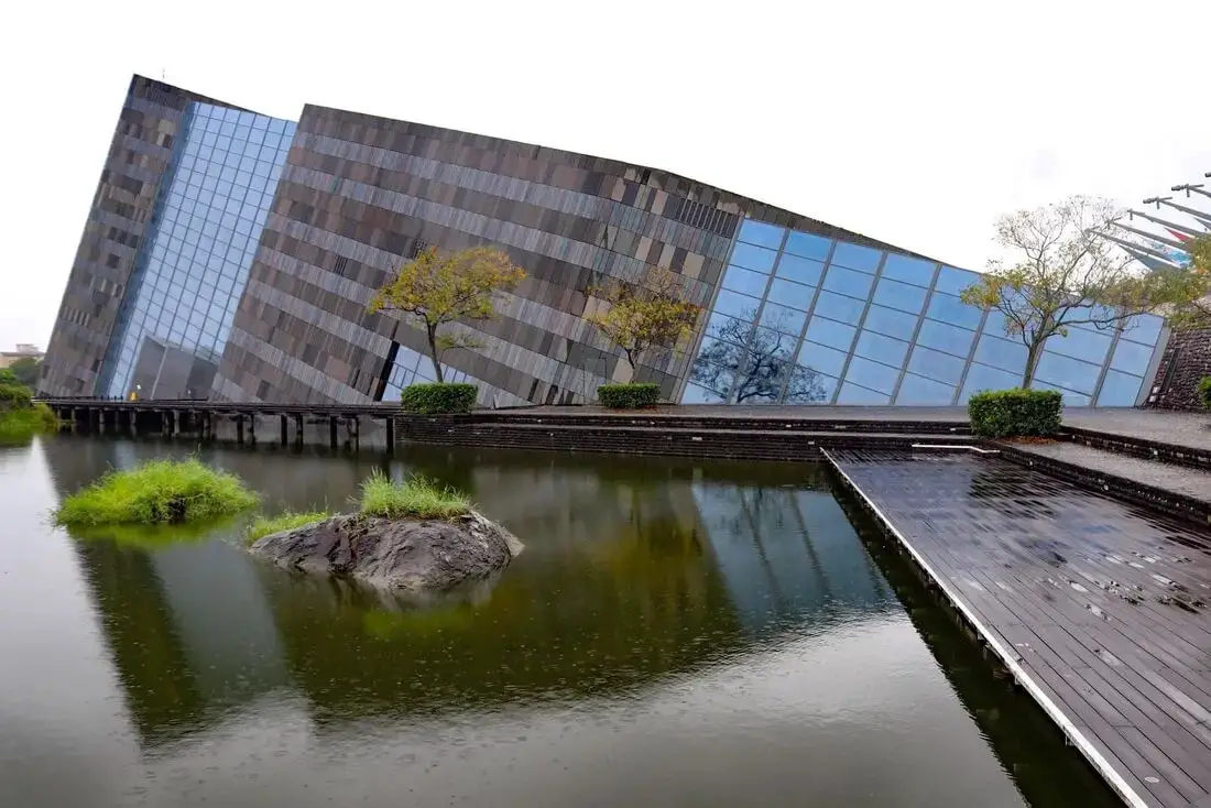
The Lanyang Museum focuses on Toucheng's history and artifacts. If you want to learn about the history of Toucheng, this is the place to visit. It is also a beautiful building, designed in the shape of Cuestas, or slanted rocks that appear commonly along Toucheng's coastline.
Background: Before Chinese settlers came, the area around Toucheng was inhabited by the Ketagalan Aboriginal tribe, whose language is now extinct. The name Toucheng literally means "first town" in Chinese, because it was the first settlement in Yilan, settled in the late 1700s. With the nearby Wushih and Touwei Harbors around the same time, it became the economic focal point of Yilan. However in the late 1800s and early 1900s Wushih Harbor and Touwei Harbor silted in, reducing their function. With the advent of the Japanese built Yilan railway line in the mid-1900's, as well as constant floods and continually silting of the harbors, Toucheng quickly lost its importance economically and fell into decay. After residents of Turtle Island were relocated to Daxi in Toucheng, Daxi Harbor was expanded and has become one of the largest fishing harbors in the area. Due to its close proximity to Taipei, Toucheng has become a major tourist area and may be the most popular surfing location in Taiwan. Price: 100 NT You can book discount exhibition tickets to the museum on KKday here or book a tour through Klook here. Hours: 9 AM to 5 PM every day except Wednesdays. Tours and Activities: You can purchase tours and tickets for many activities in Yilan such as Su'ao Crayon Castle, Taipingshan, Turtle Island, Lanyang Museum, Toucheng Leisure Farm, Zhang Mei Ama Capybura Farm, Bambi Land, Yinong Ranch, National Center for Traditional Arts, Taxi Museum, Glamping, Camping, ATV / 4-wheeling experience, SUP / paddle boarding, Ximeng Forest Theater, Surfing, Kayaking, Horse Riding, River Tracing, River Rafting, River Tubing, Pack Rafting, Water Biking, Snorkeling, Canoeing, Shrimping and many others through Klook here or KKday here. Accommodation: We have stayed at and recommend Toucheng Leisure Farm. You can also book a room there on Klook here, Agoda here, Booking.com here, Hotels.com here, Expedia here, or Trip.com here. Looking for a hotel? We recommend booking through Agoda here, which provides the best quality selection of accommodation in Taiwan. Find out where to stay in our Taiwan hotels guide or search for the best hotel deals in Taiwan here. How to get there: By TRA: Take the TRA to any of the stations in Toucheng. You can book tickets to travel to Yilan via inter-city bus on Klook here. You can book tickets to Yialn via high speed rail (HSR) on Klook here or KKDay here. Book tickets via the normal train (TRA) on Klook here. Bicycle rental: Cycling is the best way to enjoy Taiwan's landscapes if you have the time and energy. Looking for bicycle rentals in Taiwan? You can search on KKday here and search for tours on Klook here. You can also check out our Taiwan cycling guide here. By Car: From Taipei, take National Freeway 5 to Toucheng. Be careful to note that on Sundays there are highway controls for cars travelling from Yilan to Taipei from 3 PM to 8 PM, so avoid travelling back to Taipei at that time to beat the traffic. Looking for scooter rental in Yilan? You can search Klook here or KKday here to look for options. You can also check out our scooter rental guide here. If you are looking for car rentals in Yilan, you can also search Klook here or KKDay here. You can also check out our car rental guide here. Map: 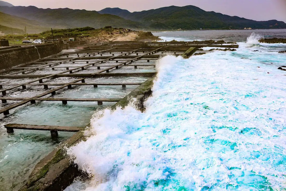
Maiyanshan is a small area on the northeast coast with aquaculture farms. There are interesting rock formations along the beach, and usually large waves here which are mesmerizing to watch. This place also has a few seafood restaurants and is worth a stop on your next trip to the northern coast.
Background: Meiyanshan (literally beautiful waves mountain) was formed thousands years ago by the collision of the Philippine and Eurasian Plates. The seaside area is named after Meiyan Mountain which watches over it. Because of its small size and with no other attractions nearby, it is often overlooked as a seaside destination. Price: Free Hours: 24/7 Tours and Activities: You can book a Stand Up Paddle Board experience at Jinshawan on Klook here or KKday here. You can book a tour to Taiwan's North Coast on TripAdvisor here, Klook here, or KKday here. Hotels on Taiwan's Northern Coast: We recommend Fullon Hotel which has locations in Tamsui and Fulong near the beach (book on Booking.com here, Tripadvisor here, Agoda here, or Hotels.com here). We have also stayed at and recommend Hai Xia Your Home which is right in front of Fulong Beach (book on Booking.com here, Tripadvisor here, Agoda here, or Hotels.com here). Looking for a hotel? We recommend booking through Booking.com here, which provides the best quality selection of accommodation in Taiwan. Find out where to stay in our Taiwan hotels guide or search for the best hotel deals in Taiwan here. How to Get There: By Bus: Take bus 1811 from Taipei bus station to Meiyanshan stop. You can purchase a discount easy card to use on the MRT and buses from Klook here or KKday here. You can also book an MRT travel pass on Klook here. By Car: Drive on provincial highway 2 out of Keelung to the northeast. The beach area is between Longdong and Ao'di. If you are looking for car rentals, you can also search Qeeq here, Klook here, or KKday here. You can also check out our car rental guide here. Looking for scooter rental in northern Taiwan? You can search on Klook here or KKday here to search for options. You can also check out our scooter rental guide here. By Bicycle: Cycling is the best way to enjoy Taiwan's landscapes if you have the time and energy. Looking for bicycle rentals in Taiwan? You can use Taiwan's many Youbike sharing stations, or search for rentals on KKday here, and search for tours on Klook here. You can also check out our Taiwan cycling guide here. You can also book a cycling tour on TripAdvisor here. For more information, check out our Taiwan transportation guide here. Map: Please see below: 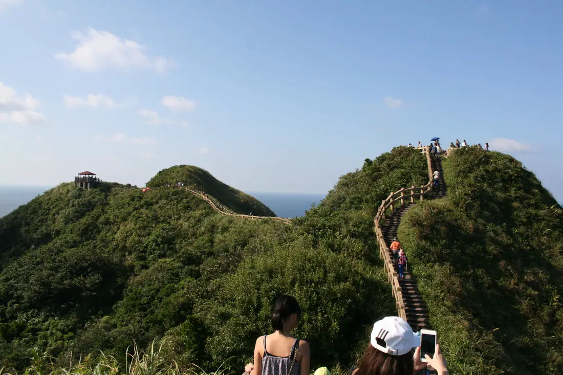
Bitou Cape (aka Bitoujiao/Bítóujiǎo) is a scenic area of coastline in Ruifang District of New Taipei, along the northeast coast, with popular hiking trails, interesting geological formations, a refurbished tourist military complex. and steep sea cliffs. It is a beautiful area along the coast that you should be sure to not miss.
Background: The sandstone that forms Bitou Cape was formed as sediment under the ocean millions of years ago and were then uplifted thanks to the collision of the Eurasian and Philippine plates. The rocks are mainly sedimentary and are part of the same formation that forms the special rock formations on the northern coast around Keelung. Because of this, there are many interesting eroded rock formations around the cape. The name Bitou (鼻頭) means the tip of the nose in Chinese. Bitoujiao Lighthouse was completed in 1897, built by the Japanese. Later it was repaired in WWII, and is still used today. The ROC army/navy military base at Bitou Cape has been sitting dormant for over 20 years, and was finally opened to the public as a rainbow "pink" military base to attract tourists on May 1st, 2020. The area is a popular weekend destination for many residents of Northern Taiwan. Hours: 24/7 Price: Free Tours: You can book a tour to Bitou Cape on KKday here or Klook here. Activities along Taiwan's Northern Coast: Don't forget that there are many activities available along Taiwan's Northern Coast such as Wakeboarding, Surfing, Speedboat Surfing, SUP / Paddle Boarding, Diving, Snorkeling Kayaking, Canoeing, Water Biking, River Tracing / Canyoneering, ATVing, Horse Riding, Archery, Tree Climbing, Glamping, Motorcycling, Motorbike Tour, Dragon Boat Racing, Shen'ao Rail Bike, and more on Tripadvisor here, Klook here, or KKday here. Hotels on Taiwan's Northern Coast: We recommend Fullon Hotel which has locations in Tamsui and Fulong near the beach (book on Booking.com here, Tripadvisor here, Agoda here, or Hotels.com here). We have stayed at and recommend Gold Mountain Ranch, which is a horse ranch and glamping destination in Jinshan. You can book a night at Gold Mountain Ranch on Klook here. You can also check out our full blog on the ranch here. We have also stayed at and recommend Hai Xia Your Home which is right in front of Fulong Beach (book on Booking.com here, Tripadvisor here, Agoda here, or Hotels.com here). Looking for a hotel? We recommend booking through Booking.com here, which provides the best quality selection of accommodation in Taiwan. Find out where to stay in our Taiwan hotels guide or search for the best hotel deals in Taiwan here. How to get there: By Car/Scooter: From Keelung, take provincial highway 2 east along the north coast until you reach the Bitou Fishing Harbor. There is limited parking near the harbor, and further free parking on the other side of the tunnel but it is a bit of a walk. If you are looking for car rentals, you can also search Qeeq here, Klook here, or KKday here. You can also check out our car rental guide here. Looking for scooter rental in northern Taiwan? You can search on Klook here or KKday here to search for options. You can also check out our scooter rental guide here. By Bus: From Keelung TRA Station, take Keelung Bus 791 east about two hours to Bitou cape. You can purchase a discount easy card to use on the MRT and buses from Klook here or KKday here. You can also book an MRT travel pass on Klook here. By Bicycle: Cycling is the best way to enjoy Taiwan's landscapes if you have the time and energy. Looking for bicycle rentals in Taiwan? You can use Taiwan's many Youbike sharing stations, or search for rentals on KKday here, and search for tours on Klook here. You can also check out our Taiwan cycling guide here. You can also book a cycling tour on TripAdvisor here. For more information, check out our Taiwan transportation guide here. Map: Please see below: 
Linshanbi Cape is a rocky area on the south side of Baishawan Beach. Here you can find great views of the surrounding area, volcanic rock formations, as well as a variety of marine life. It is a great place to connect with nature along Taiwan's North Coast.
Background: "Linshanbi is a cape located next to Baishawan (White Sand Bay) to the west of Fuguei Cape, which is the northernmost point of Taiwan. It rises about 30 meters above the sea. Kike Fuguei Cape, Linshanbi has an abundance of andesite, evidence of volcanic eruption in the distant past. A circular rock formation at the northern edge of the cape looks natural but is actually a fish trap built by fishermen in early times. Fish and shrimp that enter the trap at high tide are captured in the trap when the tidal waters recede, leaving a wide variety of marine life for viewing fish, shrimp, crabs, snails, chitons, and anemones. This is a veritable classroom for teaching children to know sea life." Price: Free Parking: There is paid parking nearby. Hours: May, June, and October 9AM - 5PM July, August, and September 9AM - 6PM Tours: You can book a tour to Taiwan's North Coast on TripAdvisor here, Klook here, or KKday here. You can book a Private Laomei Green Reef Day Tour from Taipei on TripAdvisor here or KKday here. Activities: Don't forget that there are many activities available along Taiwan's Northern Coast such as Wakeboarding, Surfing, Speedboat Surfing, SUP / Paddle Boarding, Diving, Snorkeling Kayaking, Canoeing, Water Biking, River Tracing / Canyoneering, ATVing, Horse Riding, Archery, Tree Climbing, Glamping, Motorcycling, Motorbike Tour, Dragon Boat Racing, Shen'ao Rail Bike, and more on Tripadvisor here, Klook here, or KKday here. Hotels on Taiwan's Northern Coast: We recommend Fullon Hotel which has locations in Tamsui and Fulong near the beach (book on Booking.com here, Tripadvisor here, Agoda here, or Hotels.com here). We have also stayed at and recommend Hai Xia Your Home which is right in front of Fulong Beach (book on Booking.com here, Tripadvisor here, Agoda here, or Hotels.com here). Looking for a hotel? We recommend booking through Booking.com here, which provides the best quality selection of accommodation in Taiwan. Find out where to stay in our Taiwan hotels guide or search for the best hotel deals in Taiwan here. How to Get There: By Bus: Take Keelung bus from either Danshui MRT station or Keelung TRA station. You can also take the yellow and white North Coast Shuttle Bus to Baishawan station. You can purchase a discount easy card to use on the MRT and buses from Klook here or KKday here. You can also book an MRT travel pass on Klook here. By Car/Scooter: Drive on Provincial Highway 2 out of Danshui to the northeast, or out of Keelung to the northwest. The beach area is near Sanzhi District 三芝區. If you are looking for car rentals, you can also search Qeeq here, Klook here, or KKday here. You can also check out our car rental guide here. Looking for scooter rental in northern Taiwan? You can search on Klook here or KKday here to search for options. You can also check out our scooter rental guide here. By Bicycle: Cycling is the best way to enjoy Taiwan's landscapes if you have the time and energy. Looking for bicycle rentals in Taiwan? You can use Taiwan's many Youbike sharing stations, or search for rentals on KKday here, and search for tours on Klook here. You can also check out our Taiwan cycling guide here. You can also book a cycling tour on TripAdvisor here. For more information, check out our Taiwan transportation guide here. Map: 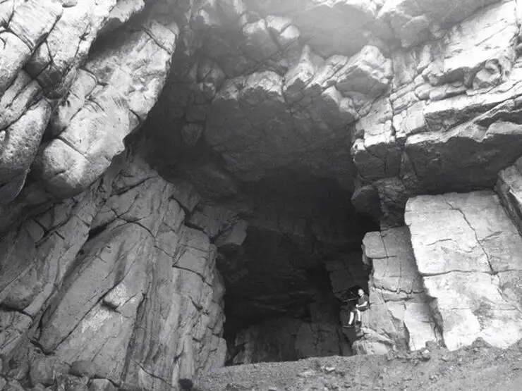
Longdong (aka Dragon Caves -龍洞 Lóngdòng) is a popular spot for snorkeling, scuba diving, and rock climbing. There is also a large sea cave there (pictured above) from where the place gets its name.
Background: The sandstone that forms Longdong was formed as sediment under the ocean millions of years ago and were then uplifted thanks to the collision of the Eurasian and Philippine plates. The rocks are mainly sedimentary and are part of the same formation that forms the special rock formations on the northern coast around Keelung. Because of this, there are many interesting eroded rock formations around the cape. The name Longdong (龍洞 Lóngdòng) means dragon cave in Chinese, named after the prominent cave in the area. The area is a popular weekend destination for many residents of Northern Taiwan. Hours: 24/7 Price: Free Tours and Activities: You can book activities at Longdong such as Rock Climbing, Cave Draping, Diving, Snorkeling, SUPing, Freediving, and more on Klook here or KKday here. How to get there: By Car/Scooter: From Keelung, take provincial highway 2 east along the north coast until you reach the Longdong. There is limited parking near the harbor, and further free parking farther away. If you are looking for car rentals, you can also search Qeeq here, Klook here, or KKday here. You can also check out our car rental guide here. Looking for scooter rental in northern Taiwan? You can search on Klook here or KKday here to search for options. You can also check out our scooter rental guide here. By Bus: From Keelung TRA Station, take Keelung Bus 791 east about two hours to Longdong. You can purchase a discount easy card to use on the MRT and buses from Klook here or KKday here. You can also book an MRT travel pass on Klook here. By Bicycle: Cycling is the best way to enjoy Taiwan's landscapes if you have the time and energy. Looking for bicycle rentals in Taiwan? You can use Taiwan's many Youbike sharing stations, or search for rentals on KKday here, and search for tours on Klook here. You can also check out our Taiwan cycling guide here. You can also book a cycling tour on TripAdvisor here. For more information, check out our Taiwan transportation guide here. Map: Please see below: 
Lovers Lake is a small lake a recreation area in Anle District of Keelung City. It has some easy trails, bridges, and a tower that looks over the area. The lake trails also connect to Dawulun Fort. Overall it is a nice scenic spot for a day trip in Northern Taiwan.
Background: The name "Lovers Lake" comes from the fact that there are actually two lakes, one larger and one smaller, so they are a like a couple in love. The sandstone that forms the area was created between 10 and 20 million years ago, and was pushed out of the sea along with northern Taiwan thousands of years ago. In the past the area was run by a private company, which went out of business. Recently the Keelung City government has taken over control, and has installed a trail that circles the lake. There is also a suspension bridge, windmill, and stone tower overlooking the lake. Nearby you can hike to Dawulun Fort or Eagle Rock that provide great views of the north coast. Currently the lake is popular with hikers and intagrammers, as well as wedding photographers. On the weekends it can get quite busy and parking can be hard to find. Hours: 24/7 Price: Free Tours: You can book a hiking tour of Lover's Lake on KKday here. Activities: Don't forget that there are many activities available along Taiwan's Northern Coast such as Yachting, Fishing, Surfing, SUP / Paddle Boarding, Diving, Snorkeling Kayaking, Canoeing, Water Biking, River Tracing / Canyoneering, Glamping, Motorcycling, Motorbike Tour, Shen'ao Rail Bike, Night Fishing, Instagram Tour, Metaverse VR experience, Seaside Picnic, and more on Tripadvisor here, Klook here, or KKday here. Hotels in Keelung: We recommend Just Live Inn-Keelung and Yung Feng Hotel, which are two great quality hotels for a reasonable price in Keelung's City Center. You can book Just Live Inn-Keelung on Booking.com here, Agoda here, Klook here, Hotels.com here, Trip.com here, or Kayak here. You can book Yung Feng Hotel on Booking.com here, Agoda here, Hotels.com here, Trip.com here, Klook here, or Kayak here, How to get there: By car/scooter: Take provincial highway northwest out of Keelung, and take a right on Jijin First Road toward Keelung Chang Kung Hospital. The Lover's lake parking lot is at the top of the hill before the road turns into one lane. There is limited parking, and you may have to park further away. The trail is not wheelchair or stroller friendly. However there is always plenty of scooter parking. If you are looking for car rentals, you can also search Qeeq here, Klook here, or KKday here. You can also check out our car rental guide here. Looking for scooter rental in northern Taiwan? You can search on Klook here or KKday here to search for options. You can also check out our scooter rental guide here. By Bicycle: Cycling is the best way to enjoy Taiwan's landscapes if you have the time and energy. Looking for bicycle rentals in Taiwan? You can use Taiwan's many Youbike sharing stations, or search for rentals on KKday here, and search for tours on Klook here. You can also check out our Taiwan cycling guide here. You can also book a cycling tour on TripAdvisor here. For more information, check out our Taiwan transportation guide here. By Bus: Unfortunately there are no buses that directly get there, so you will have to walk from provincial highway 2, or take a taxi. You can purchase a discount easy card to use on the MRT and buses from Klook here or KKday here. You can also book an MRT travel pass on Klook here. Map: Please see below: 
Heping Island Park is a geo-park and water park on Heping Island, just outside of downtown Keelung. Here you can find many interesting sedimentary rock formations along the seashore. There are also salt water swimming pools, amazing places to go diving, a playground, hiking trails, and historical sights. Some would say this island is the world's best kept secret. It is definitely worth stopping here along Taiwan's northern coast.
Historical Background: Heping Island was formed as sediment under the ocean millions of years ago and were then uplifted thanks to the collision of the Eurasian and Philippine plates. The rocks have then been slowly eroded away by wind and water, creating odd shapes that you see today. You can see similar formations atYehliu Geopark. Heping island is the closest island to the main island of Taiwan. It first part of Basay aborigine lands. Chinese fisherman first called the island Greater Keelung Island. The island was first settled by the Spanish in 1626, as their first settlement in what became their rule of northern Taiwan until they were defeated by the Dutch and left Taiwan in 1642. On Heping Island they built Fort San Salvador (聖薩爾瓦多城), which was destroyed and abandoned by the Dutch in 1668. The ruins of the fort were not confirmed to be found on the island until excavations in 2019. After the Japanese occupation of Taiwan, the island was renamed Sheliao Island (社寮島). After WWII, as part of the White Terror Movement, on March 8th, 1947 KMT soldiers kidnapped and shot some of about 30 civilians on the island that were suspected enemy conspirators, known as the Sheliao Incident "社寮事件." After this, the people on the island decided to change to island's name to "Peace Island" or Heping Island in Chinese, so that the KMT would stop harassing the local people and bring peace to the island. The Island was under KMT military control until the 1970s, after which tourists were allowed to enter the island. Now it is a popular daytime and weekend destination for many Taiwanese. Hours: 8 AM to 6 PM Price: 80 NT per person You can buy a discount entrance ticket to Heping Island Park on Klook here or KKday here. Tours: You can also book a tour to Heping Island on TripAdvisor here, Klook here, or KKday here. When to go: During the summer (May to November) when the water is warm and calm for swimming and diving. Activities: Don't forget that there are many activities available along Taiwan's Northern Coast such as Wakeboarding, Surfing, Speedboat Surfing, SUP / Paddle Boarding, Diving, Snorkeling Kayaking, Canoeing, Water Biking, River Tracing / Canyoneering, ATVing, Horse Riding, Archery, Tree Climbing, Glamping, Motorcycling, Motorbike Tour, Dragon Boat Racing, Shen'ao Rail Bike, and more on Tripadvisor here, Klook here, or KKday here. Hotels in Keelung: We recommend Just Live Inn-Keelung and Yung Feng Hotel, which are two great quality hotels for a reasonable price in Keelung's City Center. You can book Just Live Inn-Keelung on Booking.com here, Agoda here, Klook here, Hotels.com here, Trip.com here, or Kayak here. You can book Yung Feng Hotel on Booking.com here, Agoda here, Hotels.com here, Trip.com here, Klook here, or Kayak here. How to get there: By Car/Scooter: Take provincial highway 2 north out of Keelung and take a left at Zhengbin Road. Cross the bridge over to the island and head to the park which is on the north side of the island. There is paid parking in front of the park. There is paid parking in front of the park. If you are looking for car rentals, you can also search Qeeq here, Klook here, or KKday here. You can also check out our car rental guide here. Looking for scooter rental in northern Taiwan? You can search on Klook here or KKday here to search for options. You can also check out our scooter rental guide here. By Bus: From Keelung, take Keeling Bus 101 to Heping Island bus stop. You can purchase a discount easy card to use on the MRT and buses from Klook here or KKday here. You can also book an MRT travel pass on Klook here. By Bicycle: Cycling is the best way to enjoy Taiwan's landscapes if you have the time and energy. Looking for bicycle rentals in Taiwan? You can use Taiwan's many Youbike sharing stations, or search for rentals on KKday here, and search for tours on Klook here. You can also check out our Taiwan cycling guide here. You can also book a cycling tour on TripAdvisor here. For more information, check out our Taiwan transportation guide here. Map: Please see below: 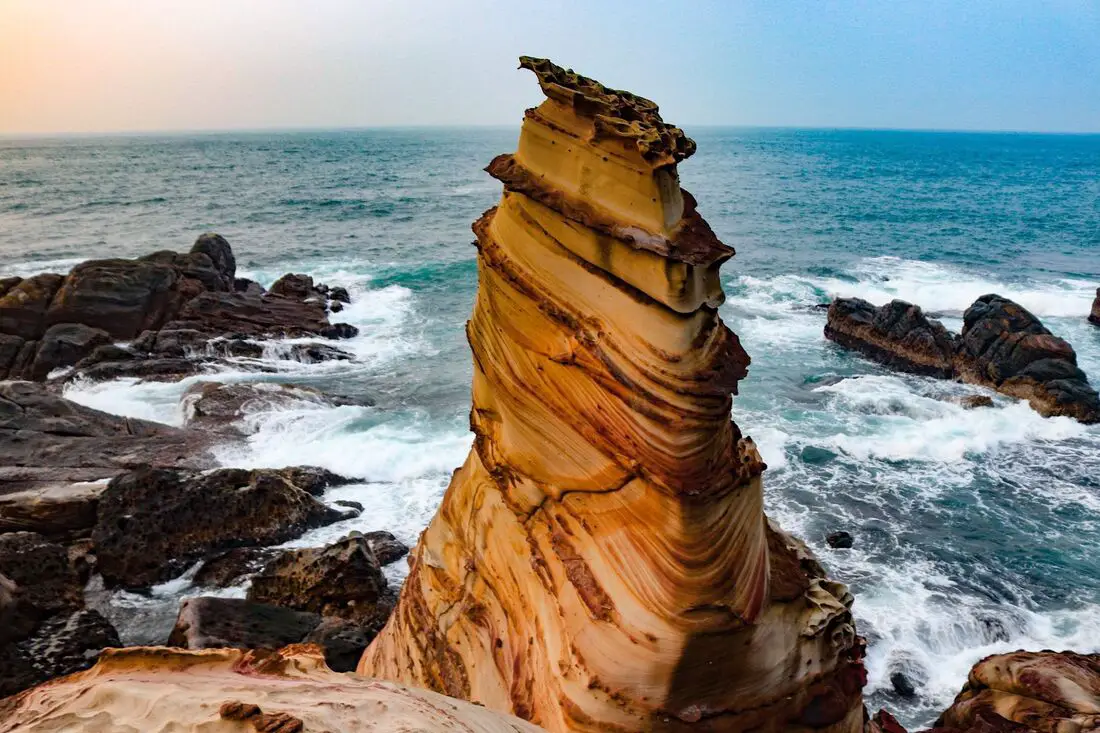
Nanya Rock (aka Nanya Peculiar Rock) is a layered sandstone column on the shore of Ruifang District, New Taipei City. There are also many interesting rock formations in the area. It is one of the most recognizable rock formations on the North coast and a popular location for kayakers, snorkelers, and Instagrammers.
Background: The sandstone and sedimentary that forms Nanya Rock formation was created between 10 and 20 million years ago, and was pushed out of the sea along with northern Taiwan thousands of years ago. The Rock was formed by easily eroding sandstone, with the area underneath being eroded away by the sea and waves. Nanya Rock is so named because it lies near Nanya Fishing Harbor in Ruifang. Hours: 24/7 Price: Free Tours: You can book a tour to Nanya Rock on Klook here or KKday here. Activities: Don't forget that there are many activities available along Taiwan's Northern Coast such as Wakeboarding, Surfing, Speedboat Surfing, SUP / Paddle Boarding, Diving, Snorkeling Kayaking, Canoeing, Water Biking, River Tracing / Canyoneering, ATVing, Horse Riding, Archery, Tree Climbing, Glamping, Motorcycling, Motorbike Tour, Dragon Boat Racing, Shen'ao Rail Bike, and more on Tripadvisor here, Klook here, or KKday here. Hotels on Taiwan's Northern Coast: We recommend Fullon Hotel which has locations in Tamsui and Fulong near the beach (book on Booking.com here, Tripadvisor here, Agoda here, or Hotels.com here). We have also stayed at and recommend Hai Xia Your Home which is right in front of Fulong Beach (book on Booking.com here, Tripadvisor here, Agoda here, or Hotels.com here). Looking for a hotel? We recommend booking through Booking.com here, which provides the best quality selection of accommodation in Taiwan. Find out where to stay in our Taiwan hotels guide or search for the best hotel deals in Taiwan here. How to get there: By Car/Scooter: Drive to Keelung, then from downtown take provincial highway 2 east about 20 KM until you reach Nanya harbor, and there is some free parking near the rock. If you are looking for car rentals, you can also search Qeeq here, Klook here, or KKday here. You can also check out our car rental guide here. Looking for scooter rental in northern Taiwan? You can search on Klook here or KKday here to search for options. You can also check out our scooter rental guide here. By Bus: From Taipei bus station, take bus 1811 to Nanya Nanxin Temple station. You can purchase a discount easy card to use on the MRT and buses from Klook here or KKday here. You can also book an MRT travel pass on Klook here. By Bicycle: Cycling is the best way to enjoy Taiwan's landscapes if you have the time and energy. Looking for bicycle rentals in Taiwan? You can use Taiwan's many Youbike sharing stations, or search for rentals on KKday here, and search for tours on Klook here. You can also check out our Taiwan cycling guide here. You can also book a cycling tour on TripAdvisor here. For more information, check out our Taiwan transportation guide here. Map: Please see below: 
Shimen Cave (aka Shimendong) is a sea cave on the Northwest Coast of Taiwan, in Shimen District of New Taipei. Its name (literally "stone gate") is the namesake for Shimen District in New Taipei. It is one of the major natural attractions along Taiwan's north coast.
Background: The sandstone that forms the Shimen Cave formation was created between 10 and 20 million years ago, and was pushed out of the sea along with northern Taiwan thousands of years ago. The cave itself was formed by wave erosion on the cave. Shimen Cave was named a protected natural sight in 1933 during the Japanese occupation of Taiwan, but has not had the same status since after WWII. Now two marble tablets sit on either side of the cave, put there by government leaders during the ROC martial law period. Hours: 24/7 Price: Free Tours: You can book a tour to Taiwan's North Coast on TripAdvisor here, Klook here, or KKday here. Activities: Don't forget that there are many activities available along Taiwan's Northern Coast such as Wakeboarding, Surfing, Speedboat Surfing, SUP / Paddle Boarding, Diving, Snorkeling Kayaking, Canoeing, Water Biking, River Tracing / Canyoneering, ATVing, Horse Riding, Archery, Tree Climbing, Glamping, Motorcycling, Motorbike Tour, Dragon Boat Racing, Shen'ao Rail Bike, and more on Tripadvisor here, Klook here, or KKday here. Hotels on Taiwan's Northern Coast: We recommend Fullon Hotel which has locations in Tamsui and Fulong near the beach (book on Booking.com here, Tripadvisor here, Agoda here, or Hotels.com here). We have also stayed at and recommend Hai Xia Your Home which is right in front of Fulong Beach (book on Booking.com here, Tripadvisor here, Agoda here, or Hotels.com here). Looking for a hotel? We recommend booking through Booking.com here, which provides the best quality selection of accommodation in Taiwan. Find out where to stay in our Taiwan hotels guide or search for the best hotel deals in Taiwan here. How to get there: By Car/Scooter: Take provincial Highway 2 from either Tamsui or Keelung North to Shimen. The Shimen Cave sits on the very northern edge of Shimen District. If you are looking for car rentals, you can also search Qeeq here, Klook here, or KKday here. You can also check out our car rental guide here. Looking for scooter rental in northern Taiwan? You can search on Klook here or KKday here to search for options. You can also check out our scooter rental guide here. By Bicycle: Cycling is the best way to enjoy Taiwan's landscapes if you have the time and energy. Looking for bicycle rentals in Taiwan? You can use Taiwan's many Youbike sharing stations, or search for rentals on KKday here, and search for tours on Klook here. You can also check out our Taiwan cycling guide here. You can also book a cycling tour on TripAdvisor here. For more information, check out our Taiwan transportation guide here. By Bus: Take Keelung bus from either Danshui MRT station or Keelung TRA station. You can also take the yellow and white North Coast Shuttle Bus to Shimendong station. You can purchase a discount easy card to use on the MRT and buses from Klook here or KKday here. You can also book an MRT travel pass on Klook here. Map: Please see below: 
Despite Taiwan being a tropical island, it also has a surprising amount of sand dunes. The Guanyin Caota Sand dunes in Taoyuan are Taiwan's longest stretch of sand dunes, over 8 KM in length. They have become a major Instagram selfie location due to being such a unique geological feature so close to Taipei.
Background: The sand dunes at Caota have been forming for thousands of years, thanks to silt being washed into the ocean from the Taoyuan plain from nearby rivers, such as the Shunagxikou River (雙溪口溪). Recently, wicket fences have been placed around the sand dunes to prevent erosion and the spread of sand in unwanted places. Also, in the past few years, many land-based wind farms have been erected here. The dunes are part of Guanyin Coastal Recreation Area, which includes a beach that may or may not ban swimming, but you can wade here, go Stand Up Paddleboarding, or surf. Recently the sand dunes have become a hot spot for Instagrammers, but the area is still usually free of people even on weekends due to the lack of convenient transportation. Hours: 24/7 Price: Free Tours: You can book a tour to the Caota Sand Dunes on KKday here. Hotels near Taoyuan: High end: We have stayed at and recommend the Yuanshan Grand Hotel, once the tallest building in Taiwan and still the most grand (book on Booking.com here, Tripadvisor here, or Agoda here). We also recommend Fullon Hotel which has locations in Tamsui and Fulong near the beach Looking for a hotel? We recommend booking through Booking.com here, which provides the best quality selection of accommodation in Taiwan. Find out where to stay in our Taiwan hotels guide or search for the best hotel deals in Taiwan here. Just to let you know, if you book using the links above, we get some commission at no cost to you. How to get there: By Car: Take Expressway 61 South from Taipei and get off at the Cata Exit (33). There is limited parking on a dirt road near the sand dunes. The way to the sand dunes is not clear, but it is a huge area and hard to miss. If you are looking for car rentals, you can also search Qeeq here, Klook here, or KKday here. You can also check out our car rental guide here. By Scooter: Follow underneath Expressway 61 South from Taipei and get off near the Cata Exit (33). There is limited parking on a dirt road near the sand dunes. The way to the sand dunes is not clear, but it is a huge area and hard to miss. Looking for scooter rental in Taoyuan? You can search on Klook here or KKday here to search for options. You can also check out our scooter rental guide here. By MRT/Bus: You can go to Dayuan MRT station, then take a bus to Guanyin or Xin Village Road. The bus ride should take about 20 minutes. Then it is another 20 minute walk to the dunes. You can also book an MRT travel pass on Klook here. By Bicycle: Cycling is the best way to enjoy Taiwan's landscapes if you have the time and energy. Looking for bicycle rentals in Taiwan? You can use Taiwan's many Youbike bike sharing stations, or search for rentals on KKday here, and search for tours on Klook here. You can also check out our Taiwan cycling guide here. For more information, check out our Taiwan transportation guide here. Map: See below: 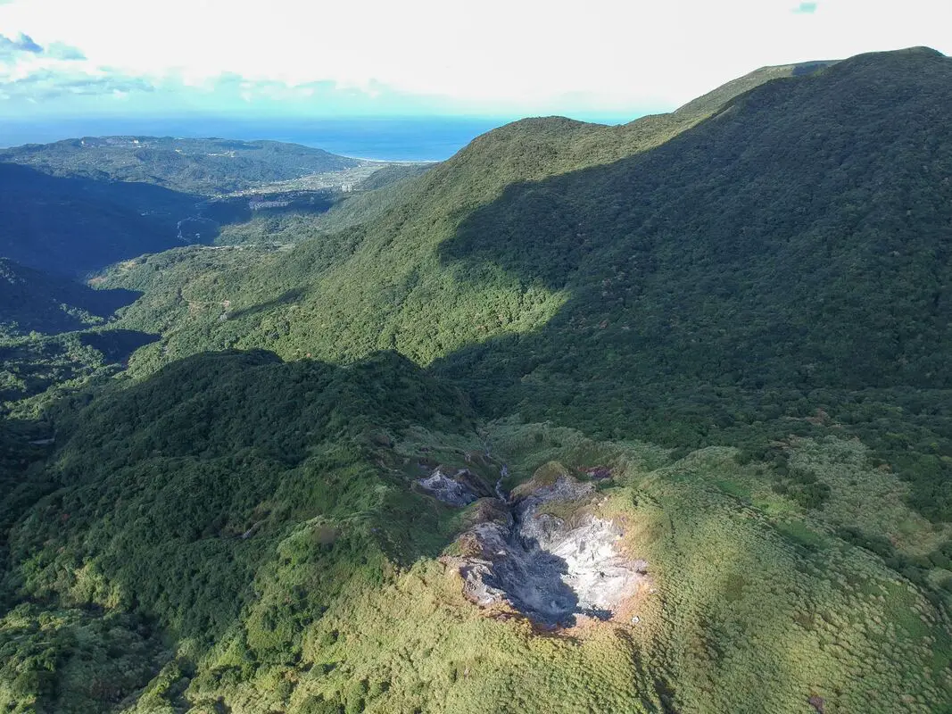
The Dayoukeng Crater in Yangmingshan National Park is the biggest sulfur vent area in Taiwan, and would likely be the first place to spew lava in the event of a volcanic eruption. This along with Turtle Island are the two known active volcanos in Taiwan. The area was also an important historical sulfur mine. Currently access to Dayoukeng is closed, but you can fly a drone hear with a permit.
Background: The area known as Yangmingshan now was formed by volcanoes about 700,000 years ago, forming many mountains about 1000 meters or less in northwestern Taiwan. The park still features active volcanoes, vents, and hot springs. The original name of the area was Caoshan (grass mountain 草山). During the Qing Dynasty, the area was used to harvest sulfur, and many of the hills were burned to help catch sulfur thieves. In 1927 during the Japanese era, Yangmingshan was made as the first national park in Taiwan, then known as Datunshan National Park Association. In 1950 after the ROC took Taiwan Chiang Kai-shek renamed the park after the philosopher Wang Yangming, and called the area Yangmingshan. In 1985, after resolving many land disputes, Yangmingshan National Park was officially designated as a national park in the ROC era. Dayoukeng (literally "Big Oil Crater" gets its name because the there are two main sulfur vents on Yangmingshan, and it is the biggest sulfur vent area in Taiwan. Temperatures here can reach 120 degrees celcious, and the water is very acidic with a PH level of only 1-2. The venting crater lies about 805 meters above sea level. A few kilometers under the ground, there is a leftover lava chamber from a previous eruption that heats up ground water and sends it spewing back to the surface. Sulfur mining at Dayoukeng Crater in Yangmingshan National Park started in the Qing Dynasty by a British mining company who first obtained the rights to mine here in 1897. Currently you can find lots of old mining equipment that were abandoned here. The Yulu Old Trail was built near Dayoukeng to transport mining materials. Mining sulfur ended with the formation of Yangmingshan National Park. Dayoukeng lies in Jinshan District of New Taipei City. It is a popular stop in Yangmingshan and has two parking lots and visitor's center. It is also one of the starting points for the Mt. Qixing Trail. Hours: The visitor's center is open from 9 AM to 4:30 PM. Price: Free (parking 30 NT) You can book tours to Yangmingshan on TripAdvisor here, Klook here, or KKday here or here. Tours: You can check out tours to Yangmingshan such as a One-day Yangmingshan NP Beitou Hot Spring Park and Tamsui Tour Package, Beitou and Yangmingshan Day Tour from Taipei, One Day Hike around Yangmingshan, or Private Yangmingshan Volcano Tour and more on TripAdvisor here, Klook here, or KKday here. Hotels in Taipei: High end: We have stayed at and recommend the Yuanshan Grand Hotel, once the tallest building in Taiwan and still the most grand (book on Booking.com here, Tripadvisor here, or Agoda here). We also recommend Fullon Hotel which has locations in Tamsui and Fulong near the beach (book on Booking.com here, Tripadvisor here, Agoda here, or Hotels.com here). Budget Hotels: We have stayed at and also recommend Fu Chang Hotel in Ximending, which is within walking distance of Ximending shopping district (book on Booking.com here, Tripadvisor here, or Agoda here). We have also stayed at and recommend Hai Xia Your Home which is right in front of Fulong Beach (book on Booking.com here, Tripadvisor here, Agoda here, or Hotels.com here). Looking for a hotel? We recommend booking through Booking.com here, which provides the best quality selection of accommodation in Taiwan. Find out where to stay in our Taiwan hotels guide or search for the best hotel deals in Taiwan here. How to get there: By Car/Scooter: From Taipei, take provincial highway 2A north to the Zhuzihu Lookout. Keep right until you reach the turnoff the the Qingtiangang parking lot. Car parking is limited on weekends and the number of cars allowed up the mountain is also limited. There is also paid scooter parking. Looking for scooter rental in Taipei? Check out Qeeq here, Klook here, or KKday here to search for options. If you are looking for car rentals, you can also search Qeeq here, Klook here, or KKday here. You can also check out our car rental guide here. By Bus: From Beitou MRT Station, Take Little Bus 9 (小9) to Qingtiangang Station (擎天崗). You can book tickets to travel to Taipei via inter-city bus on Klook here. By Bicycle: Cycling is the best way to enjoy Taiwan's landscapes if you have the time and energy. Looking for bicycle rentals in Taiwan? You can use Taiwan's many Youbike sharing stations, or search for rentals on KKday here, and search for tours on Klook here. You can also check out our Taiwan cycling guide here. You can also book a Sunset Riverside Bike Ride and Historical Tour, 4 Hour Cycling in Taipei, Ultimate 8-Hour Cycling City Tour, or Taipei City Bike Tour with Night Market Experience on TripAdvisor here. Map: Please see below: 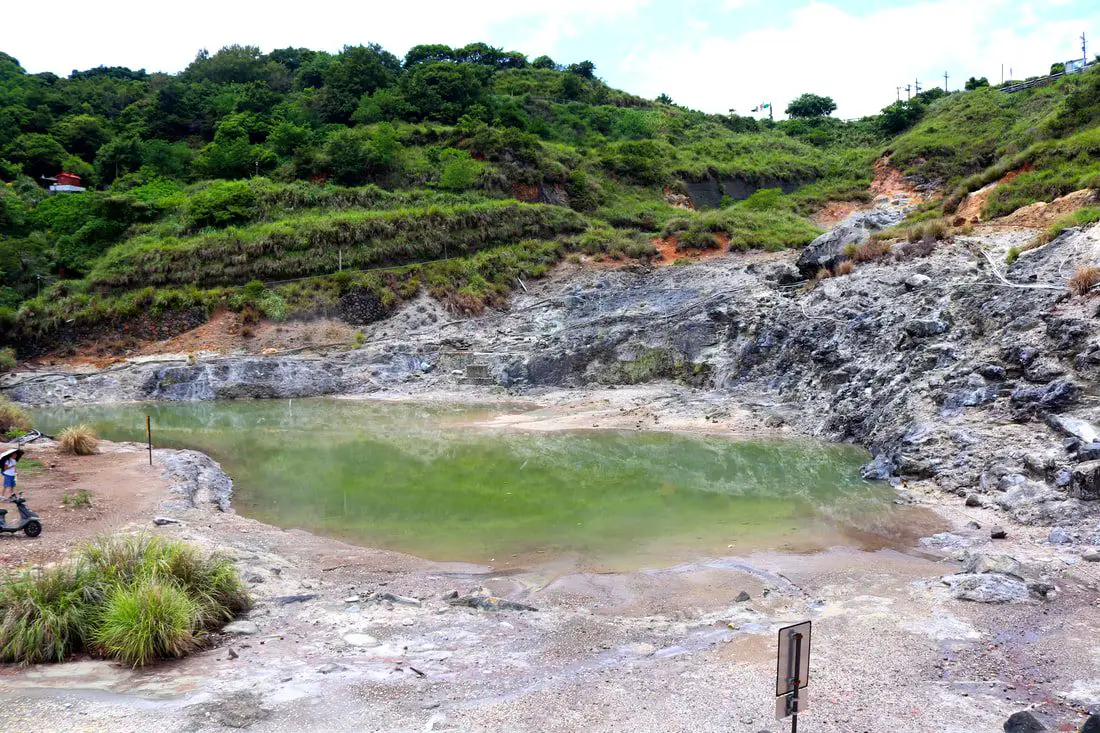
Longfeng Valley in Yangmingshan National Park is a large volcanic sulfur hot spring area with hiking trails, steam vents, sulfur deposits, and large natural hot springs. Longfeng Valley remains as a mostly untouched natural pool that retains its natural beauty without man made structures surrounding it. It is a unique and interesting stop on the mountain and worth a visit on your trip to Yangmingshan.
Background: The area known as Yangmingshan now was formed by volcanoes about 700,000 years ago, forming many mountains about 1000 meters or less in northwestern Taiwan. The park still features active volcanoes, vents, and hot springs. The original name of the area was Caoshan (grass mountain 草山). During the Qing Dynasty, the area was used to harvest sulfur, and many of the hills were burned to help catch sulfur thieves. In 1927 during the Japanese era, Yangmingshan was made as the first national park in Taiwan, then known as Datunshan National Park Association. In 1950 after the ROC took Taiwan Chiang Kai-shek renamed the park after the philosopher Wang Yangming, and called the area Yangmingshan. In 1985, after resolving many land disputes, Yangmingshan National Park was officially designated as a national park in the ROC era. The hot springs at Beitou were first converted into hot spring resorts in 1894, and Beitou become a popular hot spring location during the Japanese era, and there are many hot spring hotels and baths that exist there today. Longfeng Valley literally means "Dragon and Phoenix Valley." Longfeng Valley remains as a mostly untouched natural pool that retains its natural beauty without man made structures surrounding it. Hours: 24/7 Tours: You can book a Bath of the Gods Hot Spring Tour at Beitou, Taipei, 2-Hour Private Walking Tour in Beitou or Beitou and Yangmingshan Day Tour from Taipei and more on TripAdvisor here, Klook here, or KKday here. Hotels in Taipei: High end: We have stayed at and recommend the Yuanshan Grand Hotel, once the tallest building in Taiwan and still the most grand (book on Booking.com here, Tripadvisor here, or Agoda here). We also recommend Fullon Hotel which has locations in Tamsui and Fulong near the beach (book on Booking.com here, Tripadvisor here, Agoda here, or Hotels.com here). Budget Hotels: We have stayed at and also recommend Fu Chang Hotel in Ximending, which is within walking distance of Ximending shopping district (book on Booking.com here, Tripadvisor here, or Agoda here). We have also stayed at and recommend Hai Xia Your Home which is right in front of Fulong Beach (book on Booking.com here, Tripadvisor here, Agoda here, or Hotels.com here). Looking for a hotel? We recommend booking through Booking.com here, which provides the best quality selection of accommodation in Taiwan. Find out where to stay in our Taiwan hotels guide or search for the best hotel deals in Taiwan here. How to get there: By Bus: From Xinbeitou MRT station, take the 508 shuttle bus up the mountain to Dunu Vocational High School of Business, and then walk about five minutes down to the valley. You can book tickets to travel to Taipei via inter-city bus on Klook here. By Car/Scooter: From downtown Beitou, drive up Quanyuan Road until you reach Longfenggu Visitor's Center. You can park at the visitor's center or down in the valley below. Looking for scooter rental in Taipei? Check out Qeeq here, Klook here, or KKday here to search for options. You can also check out our scooter rental guide here. If you are looking for car rentals, you can also search Qeeq here, Klook here, or KKday here. You can also check out our car rental guide here. By Bicycle: Cycling is the best way to enjoy Taiwan's landscapes if you have the time and energy. Looking for bicycle rentals in Taiwan? You can use Taiwan's many Youbike sharing stations, or search for rentals on KKday here, and search for tours on Klook here. You can also check out our Taiwan cycling guide here. You can also book a Sunset Riverside Bike Ride and Historical Tour, 4 Hour Cycling in Taipei, Ultimate 8-Hour Cycling City Tour, or Taipei City Bike Tour with Night Market Experience on TripAdvisor here. Map: Please see below: 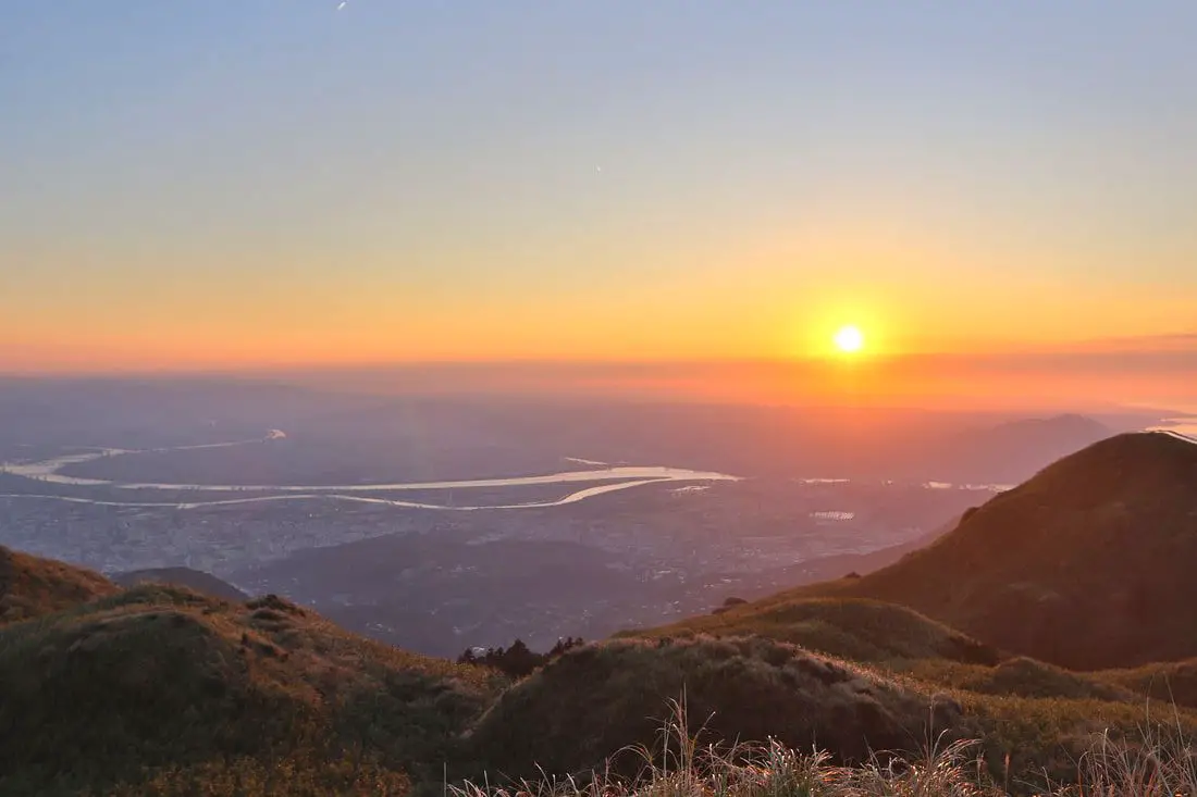
Qixingshan in Yangmingshan National Park (aka Qixing Mountain, Cising Mountain, Chising Mountain, or Seven Star Mountain) is considered the highest dormant volcanic peak in Taiwan, and the highest point in Taipei City. The area is also an important ecological area with protected species. There are a few paths to the top with varying difficulty, and it offers great views of the Taipei Basin and the sunset.
Background: The area known as Yangmingshan now was formed by volcanoes more than 700,000 years ago, forming many mountains about 1000 meters or less in northwestern Taiwan. The park still features active volcanoes, vents, and hot springs. The original name of the area was Caoshan (grass mountain 草山). During the Qing Dynasty, the area was used to harvest sulfur, and many of the hills were burned to help catch sulfur thieves. In 1927 during the Japanese era, Yangmingshan was made as the first national park in Taiwan, then known as Datunshan National Park Association. In 1950 after the ROC took Taiwan Chiang Kai-shek renamed the park after the philosopher Wang Yangming, and called the area Yangmingshan. In 1985, after resolving many land disputes, Yangmingshan National Park was officially designated as a national park in the ROC era. Qixingshan is 1120 meters tall, and is known as the highest dormant volcano in Taiwan. The last eruption here was about 700,000 years ago. Originally the peak had a crater but it slowly eroded into seven peaks, which is how it got its name. It is also known to snow in the area. Qixingshan lies in Beitou District of New Taipei City. It is a popular stop in Yangmingshan and has three main trails up to the top. There is a large viewing platform that has great views of the Taipei Basin and the sunset. Hours: 24/7 Price: Free (parking 30 NT) You can book tours to Yangmingshan on TripAdvisor here, Klook here, or KKday here or here. Tours: You can check out tours to Yangmingshan such as a One-day Yangmingshan NP Beitou Hot Spring Park and Tamsui Tour Package, Beitou and Yangmingshan Day Tour from Taipei, One Day Hike around Yangmingshan, or Private Yangmingshan Volcano Tour and more on TripAdvisor here, Klook here, or KKday here. Difficulty: There are three trails that you can take to the top. Here is a dissections of each trail: From Miaopu: Moderate: : 700 meter elevation gain, 2.4 KM of walking one way, 2 hours to the top and 2 hours back (4 hours round trip). This is the most difficult way up. From Xiaoyoukeng: Easy: 400 meter elevation gain, 1.6 KM walk one way, 40 minutes to the top and 40 minutes back (1.5 hours round trip). This is the easiest way up. From Lengshuikeng/Menghuan Pond: Easy: 450 meter elevation gain, 2.1 KM walk one way, 45 minutes to the top and 45 minutes back (1.5 hours round trip). For a more detailed comparison of the three trails, check out this blog by Josh Ellis. Hotels in Taipei: High end: We have stayed at and recommend the Yuanshan Grand Hotel, once the tallest building in Taiwan and still the most grand (book on Booking.com here, Tripadvisor here, or Agoda here). We also recommend Fullon Hotel which has locations in Tamsui and Fulong near the beach (book on Booking.com here, Tripadvisor here, Agoda here, or Hotels.com here). Budget Hotels: We have stayed at and also recommend Fu Chang Hotel in Ximending, which is within walking distance of Ximending shopping district (book on Booking.com here, Tripadvisor here, or Agoda here). We have also stayed at and recommend Hai Xia Your Home which is right in front of Fulong Beach (book on Booking.com here, Tripadvisor here, Agoda here, or Hotels.com here). Looking for a hotel? We recommend booking through Booking.com here, which provides the best quality selection of accommodation in Taiwan. Find out where to stay in our Taiwan hotels guide or search for the best hotel deals in Taiwan here. How to get there: By Car/Scooter: From Taipei, take provincial highway 2A north to Yangmingshan. There are three trails to the top: from Xiaoyoukeng 小油坑, Lengshuikeng 冷水坑, and Miaopu 苗圃. Looking for scooter rental in Taipei? Check out Qeeq here, Klook here, or KKday here to search for options. If you are looking for car rentals, you can also search Qeeq here, Klook here, or KKday here. You can also check out our car rental guide here. By Bus: From Shilin MRT Station, Take Bus 1717 to Xiaoyoukeng 小油坑, Lengshuikeng 冷水坑, Menghuan Pond 夢幻胡 or Miaopu 苗圃 parking lots. You can book tickets to travel to Taipei via inter-city bus on Klook here. By Bicycle: Cycling is the best way to enjoy Taiwan's landscapes if you have the time and energy. Looking for bicycle rentals in Taiwan? You can search on KKday here and search for tours on Klook here. You can also check out our Taiwan cycling guide here. Map: Please see below: 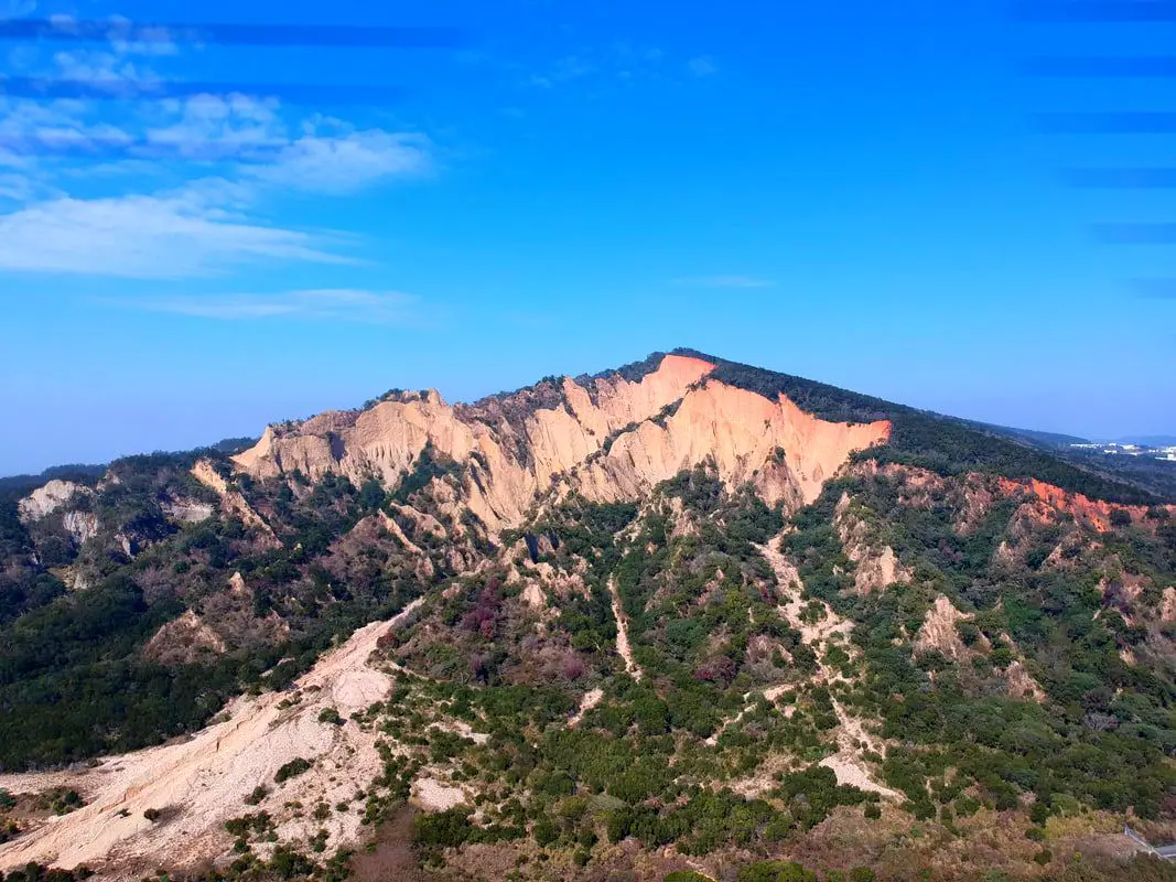
Huoyanshan (literally Fire Mountain or Mountain of Flames) is a quickly eroding mountain in Miaoli County that has deep canyons and red coloration due to mineral seepage. It's unique landscape is popular with hikers and instagrammers, and also has great views of Taichung and the surrounding area.
Background: Like much of the area around it, Huoyanshan was formed when the land was lifted up due to tectonic factors, but the side of the sandstone mountain has been eroded away by heavy rainfall and the Da'an River creating a large canyon. Discoloration due to laterization (leaching and oxidation due to heavy rain) of minerals in the sediment has made the rocks near the top of the mountain here orange-red. The Mountain at its highest point is 614 meters above sea level, and is one of Taiwan's 100 lesser peaks (小百岳). In 1984, the area was made into a protected nature reserve, andclosed off to the public due to danger from erosion. Now that is reopened, it is a very popular hiking and bird watching destination. Anyone travelling north on National Freeway 1 will have a great view of the mountain on the left as they leave Taichung into Miaoli. Price: Free Hours: 24/7 Time needed to hike (round trip): 3-4 hours, easy hike Tours: There are many tours and activities available in Miaoli such as Schokolake Chocolate Factory, Shangshun World, West Lake Resortopia, Suweila Manor, Baba Kengdao, Hobbit Valley, Zhuo Ye Cottage Duck Box and more on Klook here or KKday here. Accommodation: We have stayed at and recommend Beautiful Landscape Resort, a fish farm and resort near Nanzhuang Old Street (you can book on Agoda here, Booking.com here, Hotels.com here, or Expedia here), and Yuan Motel, a high class car motel which includes a great breakfast buffet (you can book on Agoda here, Booking.com here, Hotels.com here, or Expedia here). Looking for a hotel? Find out where to stay in our Taiwan hotels guide or search for the best hotel deals in Taiwan here. You can also book Wifi and SIM cards for Taiwan on Gigago here. Need travel insurance? Compare prices on Insubuy here. Just to let you know, if you book using the links above, we get some commission at no cost to you, and you can help support our blog. You can click here to receive $5 USD on your first Klook purchase. How to get there: By Car/Scooter: Travel south on provincial highway 13 in Mioali until you reach Bogongkeng (伯公坑); at that point you can park on the side of the road and head up Bogongkeng Village, the trail head starts at the top of the road. If you are looking for car rentals, you can also search Qeeq here, Klook here, or KKday here. You can also check out our car rental guide here. Looking for scooter rental in Miaoli? Check out Klook here or KKday here to search for options. You can also check out our scooter rental guide here. You can also check out our car rental guide here. By Bus: Take Hsinchu Bus 5665 from Sanyi TRA station to the Bogongkeng bus stop. You can book tickets to travel to Miaoli via inter-city bus on Klook here. You can book tickets to Miaoli via high speed rail (HSR) on Klook here or KKDay here. Book tickets via the normal train (TRA) on Klook here. By Bicycle: Cycling is the best way to enjoy Taiwan's landscapes if you have the time and energy. Looking for bicycle rentals in Taiwan? You can search on KKday here and search for tours on Klook here. You can also check out our Taiwan cycling guide here. Map: Please see below: 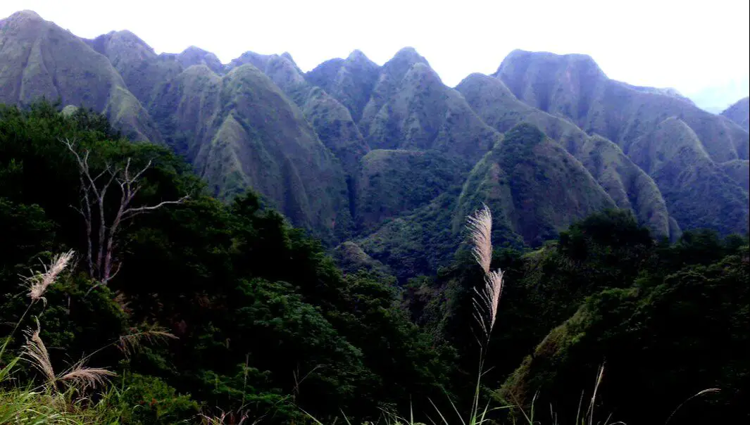
The 99 Peaks Trail (aka Jiujiufeng Forest Trail or 九十九峰) in Caotun Township of Nantou County is one of the most unique and beautiful places in Taiwan. It features extremely steep grassy hills that look like they are from a cartoon. This is due to the easily eroding sediment that they are made out of. Taiwan's torrential rains and earthquakes have sped up the erosion on these hills, making them especially steep and pointy, and creating what looks like 99 peaks on the horizon. From the trail one clearly see the jagged 99 peaks as well as beautiful views of Caotun and Nantou.
Background: The 99 Peaks are built on the same sediment as Huoyanshan, with iron rich soil that was deposited and lifted up due to tectonic forces. Discoloration due to laterization (leaching and oxidation due to heavy rain) of minerals in the sediment has made the rocks near the top of the mountain here orange-red. Like Tianliao Moon World (田寮月世界) and Liji Badlands (利吉惡地), 99 Peaks is considered a badland due to fast erosion. 99 Peaks, Huoyanshan (火炎山), and Shibaluohan Mountain (十八羅漢山) make up the three "Huoyanshan formations" in Taiwan. The slopes here are very steep, and average from 60-80 degrees, making them impossible to cultivate. The entire mountain area is like a bunch of mini slot canyons. At it's highest point, the 99 peaks are 779 meters above sea level, but were only 777 meters above sea level before the 921 earthquake. After the 921 earthquake, much of the soil on the mountain eroded away due to shaking, and the hills were left bare. Shortly after, the area was declared a nature reserve. 21 years after the earthquake, the hills are now covered in grass and shrubs. The trail doesn't go to the very top of the peaks, and if you venture further be careful because the cliffs are very steep on either side and erosion could happen at any time. As of March 2020, Nantou County has purchased the land of 99 Peaks for 100 million NT, in hopes of cultivating it for tourism, such as hot air balloon rides. Let's hope it becomes a major tourist destination! Hours: 24/7 Price: Free Length: 1 KM one way About 1 hour total About 200 meters of elevation gain. Difficulty: Easy Tours: There are many tours and activities available in Nantou such as river Tracing, paragliding, Shanlinxi Forest Recreation Area 杉林溪, Cona's Chocolate Castle, Shuiyuan Suspension Bridge, JOJOZOO Park, and Aowanda Forest Recreation Area. You can find more tours of Nantou on Klook here or KKday here. Accommodation: We have stayed at and recommend Jenq Yang Hotspring Hotel (you can book on Agoda here, Booking.com here, Trip.com here, or Klook here), a hot spring hotel near the mystical Lushan hot spring, and Maple Leaf Holiday Villa (you can book on Agoda here, Booking.com here, Hotels.com here, Expedia.com here, Trip.com here, or Klook here), a lodge with a great view and within walking distance of Cingjing Farm. I also have stayed at and recommend Kirin Villa (you can book on Agoda here or Booking.com here), a mountain resort in Puli near Sun Moon Lake. Looking for a hotel? Find out where to stay in our Taiwan hotels guide or search for the best hotel deals in Taiwan here. We recommend booking through Agoda here, which provides the best quality selection of accommodation on the islands. You can also book Wifi and SIM cards for Taiwan on Gigago here. Just to let you know, if you book using the links above, we get some commission at no cost to you, and you can help support our blog. You can click here to receive $5 USD on your first Klook purchase. How to get there: By Car: Take National Freeway 6 toward Puli and get off at the east Caotun interchange. Then drive east on provincial highway 14 until you reach Jianxing Rad intersection on the other side of the river. Turn left and keep going until you reach the trail head. If you are looking for car rentals, you can also search Qeeq here, Klook here, KKday here. You can also check out our car rental guide here. By Scooter: Ride east on provincial highway 14 until you reach Jianxing Rad intersection on the other side of the river. Turn left and keep going until you reach the trail head. Looking for scooter rental in Nantou? Search Klook here or KKday here to search for options. You can also check out our scooter rental guide here. By Bus: Take bus 6268A east out of Caotun and get off at Pinglin Station. From there it is about a 20 minute walk to the trailhead. You can book tickets to travel to Nantou via inter-city bus on Klook here. You can book tickets to Taichung via high speed rail (HSR) on Klook here or KKDay here, or book tickets via the normal train (TRA) on Klook here, then switch to a bus to Nantou. Bicycle Rental: Cycling is the best way to enjoy Taiwan's landscapes if you have the time and energy. Looking for bicycle rentals in Taiwan? You can search on KKday here and search for tours on Klook here. You can also check out our Taiwan cycling guide here. Map: Please see below: 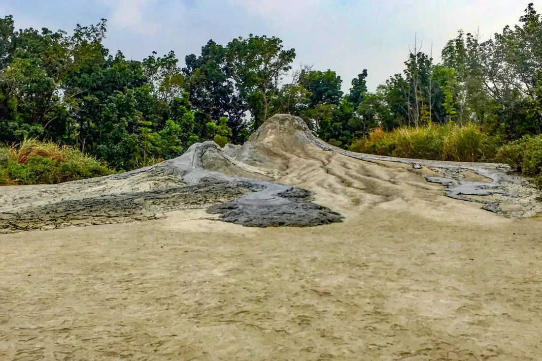
Ever want to see an active volcano up close? You can at the mud Volcanos in Wushanding Nature Preserve, Yanchao District of Kaohsiung. These spew out mud all day, which piles up and then gets washed away by rain. It is a unique and beautiful geological oddity worth visiting. These are the largest and most concentrated mud volcanoes in Taiwan.
Geological History: Wushanding Mud Volcanoes are part of a stretch of badlands that cover a large swath of southern Taiwan near the central mountain range in rural Tainan and Kaohsiung. Typical badlands are found in dryer climates, are composed of sedimentary rocks, typically have very little vegetation, and have deep valleys or ravines. The badlands in Taiwan are unique in that they are in a tropical rain forest. How is this possible? The soil at Wushanding is composed of mudstone, sandstone, shale, and chalk. Because of high alkaline levels due to chalk in the soil, trees and grass cannot grow very well. The lack of vegetation as well as high rainfall gives way to quick eroding hills, or badlands. The local Rivers also helped to carve out the landscape and bare hills. Due to vents in the earth's crust as well as deep pressures, water is pushed up to form these mud volcanoes. Nearby are also some natural gas vents, such as the ones at Guanziling Fire and Water Cave. The area around Yanchao is full of badlands and mud volcanoes, but the volcanoes at Wushanding are the most concentrated and pronounced in all of Taiwan. Wushanding was declared a protected area in 1992. Because of limited public transportation, normally there are not too many visitors but the weekends can be busy. Hours: 9 AM to 4:30 PM every day Price: Free! But you have to register in order to enter the park. Accommodation We have stayed at and recommend Chao She Hotel (you can book on Agoda here, Booking.com here, Hotels.com here, or Expedia here) IHI Sanduo Travel Hotel (you can book on Agoda here, Booking.com here, Hotels.com here, or Expedia here), and Mingli Hotel (you can book on Agoda here, Klook here, or Hotels.com here) which are three inexpensive and high quality choices in downtown Kaohsiung. I also have stayed at and recommend Kaohsiung Meinong Rabbit Paul Homestay B&B (you can book on Agoda here, Booking.com here, or Trip.com here), a quiet B&B in rural Meinong, and Chengching Lakeside Resort (you can book on Agoda here, Booking.com or Trip.com here)and the Grand Hotel Kaohsiung (you can book on Agoda here, Booking.com here, Hotels.com here, or Expedia here) which both offer breakfast buffet and free entrance into Chenqing Lake Park. I have also stayed at the 85 sky tower which offers great views of the city; you can search for rooms in the 85 sky tower on Agoda here, Booking.com here, Hotels.com here, Expedia here, or Trip.com here). Find out more about where to stay in our Taiwan hotels guide or search for the best hotel deals in Taiwan here. We recommend booking through Agoda here, which provides the best quality selection of accommodation on the islands. You can also book Wifi and SIM cards for Taiwan on Gigago here. Need travel insurance? Compare prices on Insubuy here. Tours: You can find more tours and activities in Kaohsiung such as Pier 2, Meinong Hakka Museum, Hamasen Railway Museum, Suzuka Circuit Park, i-Ride Kaohsiung Visual 5D Flying Theater, National Science and Technology Museum , Senya Village Restaruant, Austin Land, Ski School Indoor Ski Slope, and many more on Klook here or KKday here. Just to let you know, if you book using the links above, we get some commission at no cost to you, and you can help support our blog. You can click here to receive $5 USD on your first Klook purchase. How to Get There: By Bus: From Eda World, take bus 7A to Kaohsiung Normal University. It is about a 20 minute walk from the university. Looking for scooter rental in Kaohsiung? You can check out Klook here or KKday here to search for options. You can check also out our scooter rental guide here. If you are looking for car rentals, you can search Qeeq here, KKday here, or Klook here. You can also check out our car rental guide here. By Car/Scooter: Take National Freeway 10 East out of Kaohsiung and get off at the Yanchao exit (or travel by scooter under the freeway). Then travel east on provincial highway 22 passed National Kaohsiung University of Science and Technology. You will have to use google Maps to turn left onto a one lane country back road to find the mud volcanoes. You can book tickets to travel to Kaohsiung via inter-city bus on Klook here. You can book tickets to Kaohsiung via high speed rail (HSR) on Klook here or KKDay here. Book tickets via the normal train (TRA) on Klook here. You can also book a Kaohsiung Travel pass here. Map: Please refer to the map below: |
Author 作家I am an American expat who has extensive experience living, working, and traveling in Taiwan. In my day, I had to learn many things about Taiwan the hard way. But I have come to learn that Taiwan is one of the best places in the world for Foreigners to live. This blog does not represent the opinions of every foreigner in Taiwan. I am just trying to help others learn more about this beautiful country. Categories
|
 RSS Feed
