

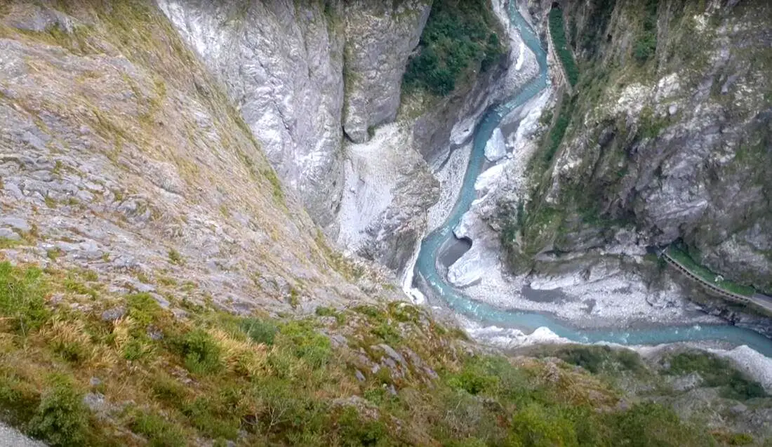
If you only have a few days in Taiwan and you want to go somewhere outside of Taipei, you should definitely go to Taroko National Park. On an island full of mountains, rain forests, beaches, and abounding natural beauty, Taroko might just take the top spot as the most beautiful scenic area in Taiwan.
Taroko National Park is well known for its amazing marble cliffs and canyons carved out by the Liwu River. It is also a popular spot for hiking, rafting, and river tracing. If you have the time, come to the East coast and see it. If you don't have time, then make some time! History and Background: Taroko National Park is well known for its marble cliffs and canyons, and is also known as "The Marble Gorge." Millions of years ago, the rock we see today was sediment at the bottom of the Pacific Ocean, but oceanic and tectonic pressure turned it into limestone, and later into marble. Later the Eurasian plate was uplifted where Taiwan is today, and a gorge was cut out of the limestone thanks to the Liwu River. Taroko means "human being," from the Truku tribal language. Originally the Tupido Tribe settled in the area of what is now Tianxiang Taiti mesa. They built the Tupido Tribe Trail which was only 30 cm wide, and resided there until they were massacred by the Japanese in 1914. In 1917, the Japanese expanded the original trail made by the Tupido Tribe to 1.5 M and forced aboriginal tribesmen to carry goods along the trail to the east coast. This is now the Zhuilu Old Trail. Currently only 3km of the trail is open to the public. The Japanese created a national park in the Area in 1937, which was disestablished by the ROC in 1945, and then reenstated in as a national park in 1986. When to visit? Hualien is great year round, but it can get a little hot in the summer, and Typhoon season and heavy rain season lasts from about May to October. If you are afraid of the heat and rain then you can visit during winter when the temperatures are mild and the climate is usually dryer. Sponsored Links Where to stay? Most of the accommodation you will find is near the city center. If you only want to visit Hualien City and Taroko Gorge, you can consider booking a hotel near downtown, walking or cycling around the city, and taking a bus to Taroko Gorge. We have stayed at and recommend Dream Taiwan Homestay (Agoda / Booking.com / Expedia / Hotels.com), a high quality hostel for the money in downtown Hualien, Farglory Hotel (Agoda / Booking.com / Expedia / Hotels.com), right next to Farglory Ocean Park with amazing views of Hualien, and Goldenflower B&B (Agoda / Booking.com) in Yuli right next to Sixty Stone Mountain. You can find out where to stay in our Taiwan hotels guide or search for the best hotel deals in Taiwan here. How to get there: By Car: From Taipei, Take National Highway 5 to Yilan and then drive on the Suhua Highway 9 to Hualien. A few miles before Hualien City, the gorge will be on your right. By Train: Take the train to Hualien station, and from there you can rent a scooter or car, or take a tour bus to the gorge. For more travel information see here. You can book tickets to travel to Hualien via inter-city bus on Klook here. Book tickets via the normal train (TRA) on Klook here. Need travel insurance? Compare prices on Insubuy here. How to get around in Taroko Gorge: As always, we recommend renting a scooter as the best way to see Taiwan. However, you can also a great deal of Tainan by taking the train, inter-city bus, local bus, biking, or just walking. Getting around in a car is also a convenient option as there is plenty of parking pretty much everywhere in this less crowded county. By Bus: You can book a shuttle bus to Taroko Gorge from Hualien on Klook here. Scooter Rental: Looking for scooter rental in Hualien? You can search KKday here or Klook here to look for options. You can also check out our scooter rental guide here. Car Rental: If you are looking for car rentals in Hualien, you can also search Klook here or KKDay here. You can also check out our car rental guide here. Tours: You can find more tours and activities in Hualien such as Surfing, Paragliding, SUP / Paddle Boarding, Kayaking, Canoeing, River Tracing, River Rafting, Whale Watching, Snorkeling, Diving, ATV / 4-wheeling, Paintballing, Farm Dream Estates Zoo, Water Biking, Oyster Harvesting, Shrimp Harvesting, Indigenous Experience, Glamping, Cycling, Ziplining and much more on Klook here or KKday here. You can also book Wifi and SIM cards for Taiwan on Gigago here. Just to let you know, if you book using the links above, we get some commission at no cost to you, and you can help support our blog. You can click here to receive $5 USD on your first Klook purchase. Hours: 8:30AM-5PM (Zhuilu old trail is open from 7AM to 10PM). Flying a Drone? Apply for a drone permit here. Price: Free! (Except Zhuilu old trail, which is 200 NT per adult. See below for more info.) Map: Please see below:
0 Comments
Taipei is full of very accessible hikes right next to the city center. You can find amazing views of Taipei City, as well as make some adrenaline pumping hikes up some very steep peaks in New Taipei and Keelung. We highly recommend checking out what hikes Taipei has to offer. In this guide, we will list out some of the most amazing hikes around Taipei.
Safety Tips When Hiking in Taipei:
Basic Taipei Travel Tips:
When should you go to Taipei? In my opinion, the best weather in Taipei is from March-May, and October - November, when the temperatures stay around 26 degrees Celsius and there is not as much rain. Summers are also nice, with the most sunny weather, but also hot and rainy. Winters can be cold (but not below freezing) and usually wet. Overall, there is no wrong answer as to what time of year you should visit Taipei. You will have a great time here at any time of year. Hotels in Taipei: High end: We have stayed at and recommend the Yuanshan Grand Hotel, once the tallest building in Taiwan and still the most grand (book on Booking.com here, Tripadvisor here, or Agoda here). We have also stayed at and recommend the Grand Hyatt (book on Booking.com here, Tripadvisor here, Agoda here, or Hotels.com here), Marriot (book on Booking.com here, Tripadvisor here, Agoda here, or Hotels.com here), Sheraton (book on Booking.com here, Tripadvisor here, Agoda here, or Hotels.com here), Shangri-la (book on Booking.com here, Tripadvisor here, Agoda here, or Hotels.com here), and Regent (book on Booking.com here, Tripadvisor here, Agoda here, or Hotels.com here), which are all very high quality hotels in the middle of Taipei City. We also recommend Fullon Hotel which has locations in Tamsui and Fulong near the beach (book on Booking.com here, Tripadvisor here, Agoda here, or Hotels.com here). Budget Hotels: We have stayed at and recommend and also Fu Chang Hotel in Ximending, which is within walking distance of Ximending shopping district (book on Booking.com here, Tripadvisor here, or Agoda here). We have also stayed at and recommend Hai Xia Your Home which is right in front of Fulong Beach (book on Booking.com here, Tripadvisor here, Agoda here, or Hotels.com here). Looking for a hotel? We recommend booking through Booking.com here, which provides the best quality selection of accommodation in Taiwan. Find out where to stay in our Taiwan hotels guide or search for the best hotel deals in Taiwan here. Tours in Taipei: There are many tour itineraries that you can enjoy in Taipei that will take you to multiple destinations and arrange transportation. For more information, you can check out Tripadvisor here, KKday here or Klook here, which are both great tour websites that can connect you with the right tour and tour guide for you. Here are some of the post popular tours of Taipei on Tripadvisor:
Attractions in Taipei: There are many attractions that you can enjoy in Taipei such as Taipei 101 Observatory, Taipei 101 460 Skyline Observatory, Taipei Children's Amusement Park, Maokong Gondola, National Palace Museum, Yehliu Ocean World, Yehliu Geopark, National Museum of Marine Science and Biology, i-ride 5D cinema, Astronomical Museum, Miniatures Museum of Taiwan, Double Decker Sightseeing Bus, Miramar Ferris Wheel Ticket, Taipei Zoo, Heping Island Park, Ju Ming Museum, Yuanshan Hotel Secret Road, National Taiwan Museum, New Taipei Gold Museum, Futian Leisure Farm, Chiang Kai-shek Shilin Residence, Chi Po-lin Museaum, Beitou Museum, Tsao Wonderland, Railway Museum, Fort San Domingo, 13 Levels Archaeology Museum, Austin Land, Museum of World Religions, Formosan Aboriginies Museum, ASE Parent-child Park, teamLab Future Park, Yukids Island, VR Experience, Bat Cave, Neidong Waterfall, Candlestick Islet, Jurassic Snow Park, Zhonghe High5 Amusement Park, Longshan Temple, Xingtian Temple, Ningxia Night Market, Yansan Night Market, Meteor Garden, Yingge Old Street, and many more attractions on Tripadvisor here, Klook here, or KKday here. Activities in Taipei: Indoor Skiing, Rock Climbing, Hiking, Wakeboarding, Surfing, Speedboat Surfing, SUP / Paddle Boarding, Diving, Snorkeling Kayaking, Canoeing, Water Biking, River Tracing / Canyoneering, ATVing, Horse Riding, Cooking Class, Archery, Ice Skating, Roller Skating, Tree Climbing, Urban Camping, Glamping, Motorcycling, Motorbike Tour, Dragon Boat Racing, Escape Room, Shen'ao Rail Bike, Laser Gun Experience, Batting Cages, Bowling, Paintball, Flight Simulation Experience, Taipei Tram Driving Experience, Rail Simulation Experience, Taipei 101 Observation Deck activity, Strawberry Picking, Professional Photo Shoot, Body Relaxation SPA, Night Tour, Calligraphy Workshop rand more on Tripadvisor here, Klook here, or KKday here. Just to let you know, if you book using the links above, we get some commission at no cost to you, and you can help support our blog. Some of the Klook links may not work if you are using an Ad blocker. You can click here to receive $5 USD on your first Klook purchase. How to get there: The only way to get to Taiwan is via airplane. Planes leave daily from Taipei's Songshan and Toayuan Airport. Taoyuan Airport: Taoyuan is Taiwan's largest airport and typically has cheaper flights and more flight times to choose from. It's about an hour's journey from Taoyuan Airport to the center of Taipei. You can travel via MRT, HSR, bus, or taxi to get to Taipei. You can get 30% off the Taoyuan Airport VIP lounge on KKday here. Songshan Airport: Songshan is a small airport in Taipei's city center, and can be a convenient option for people traveling within Asia. The airport is right on the Taipei MRT brown line. You can book cheap flights to Taiwan on KKday here, Trip.com here, CheapO Air here, or Kiwi here. How to get around in Taipei: Taipei's transportation system is convenient and safe. There are many options you can consider to get around in Taipei below: By Train: Gets you to the city center of all major cities in Taiwan. It is about 800NT to get from Taipei to Kaohsiung. Roughly half the price of the HSR. Book tickets via the normal train (TRA) on Klook here. By HSR: (High-Speed Rail) – Gets you quickly from north to south. Besides Taipei and Kaohsiung, most of the stations are far from city centers. It costs about 1500NT to get from Taipei to Kaohsiung. You can book tickets to the high-speed rail (HSR) on Klook here or KKDay here. By MRT: (Mass Rapid Transit, Metro train, subway) – Easily gets you around Taipei and Kaohsiung. You can also book an MRT travel pass on Klook here. By Bus: Buses can be tricky. Long-range buses such as Ubus and King Bus are easier to understand and cheaper than the local train. They can take you to the city center of every city throughout Taiwan and to remote tourist destinations such as sun moon lake. A long-range bus from Taipei to Kaohsiung is about 500 NT. You can also book tickets to travel to Shifen via inter-city bus on Klook here. You can also book a Taipei Sightseeing: Hop On, Hop Off Open Top Bus on TripAdvisor here. By Taxi: You can take short rides for about 150 NT, or hire a Taxi for a day for around 150 USD. By Car: If you are looking for car rentals, you can also search Qeeq here, Klook here, or KKday here. You can also check out our car rental guide here. By Scooter: Looking for scooter rental in Taipei? Click here or here to search for options. You can also check out our scooter rental guide here. By Bicycle: Cycling is the best way to enjoy Taiwan's landscapes if you have the time and energy. Looking for bicycle rentals in Taiwan? You can use Taiwan's many Youbike bike sharing stations, or search for rentals on KKday here, and search for tours on Klook here. You can also check out our Taiwan cycling guide here. You can also book a Sunset Riverside Bike Ride and Historical Tour, 4 Hour Cycling in Taipei, Ultimate 8-Hour Cycling City Tour, or Taipei City Bike Tour with Night Market Experience on TripAdvisor here. For more information, check out our Taiwan transportation guide here. Tourist Site Map: Check out our map below of tourist sites in Taiwan, which is constantly updated: 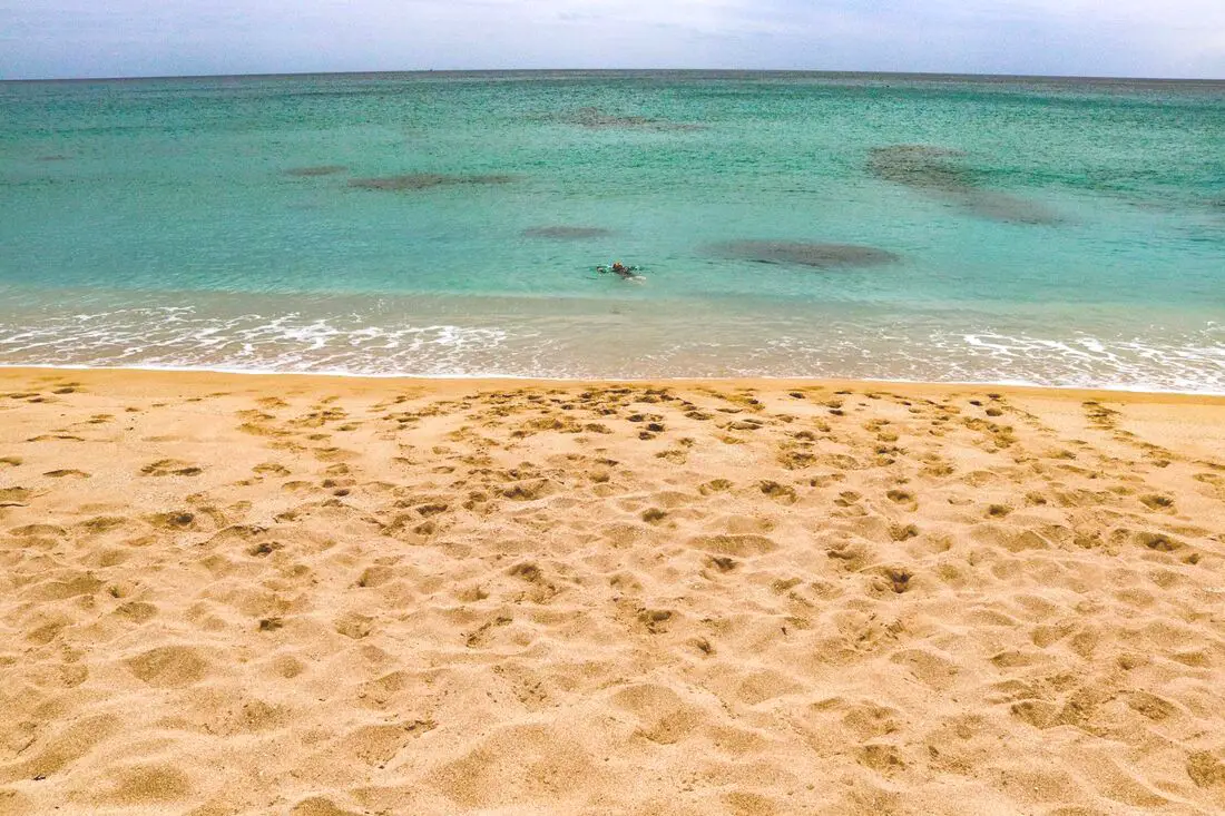
Yes, you should go to Kenting. Kenting has some of the best natural scenery in Taiwan, from beautiful white sand beaches that are warm year round to limestone mountains with hundreds of caves and waterfalls to explore. Although it may not be a world class beach resort destination yet, it should definitely be on your list on your trip to Taiwan.
Historical Background: The area around the Hengchun Peninsula was once coral that has been uplifted over millions of years. The first people to live here were Taiwan aboriginals, from the Paiwan and Puyuma tribes (who caused the Rover Incident as portrayed in Seqalu: Formosa 1867). Kenting was first settled by Han farmers and fishermen during the Qing Dynasty. The word Kenting comes from two words that mean cultivate (ken3 墾) and strong man (丁 ding1). During that time, a group of strong men (or Zhuang Ding 壯丁) came from Guangdong, who were basically Chinese pioneers of the area to cultivate the land, hence the area was named Kenting for them. The aboriginal people were mostly assimilated with the local Chinese population. The area was considered to be made into a park during the Japanese occupation due to it being the only tropical location in the Japanese Empire, but was never officially created. During the Japanese era, Nanwan was used as a whaling area and there were a few fishing villages here. The Whaling industry continued here in the ROC era until the international ban on whaling in 1986. Kenting National Park was established in 1984 as the first national park in Taiwan after WWII. Kenting became a major vacation spot, becoming a center for hostels and hotels for travelers. Kenting is considered by many to have the best beaches in Taiwan. This is because of its fine white sand and year-round warm temperatures and sunshine (it is in the tropical part of Taiwan after all). When to go: Summer is the best time to go because there is warm sunny weather and not a lot of wind. However, there are more people and there may be Typhoons. Winters are windy and colder, but the water is still warm enough to swim in. Winter is a better time for activities like hiking and surfing. How to get there: By Car/Scooter: Take provincial highway 1 south to the bottom of Taiwan until it becomes provincial highway 26. After that keep going past Hengchun into Kenting National Park. Looking for scooter rental in Kenting? Click here or here to search for options. If you are looking for car rentals, you can also search Qeeq here, Klook here, or KKday here. You can also check out our car rental guide here. By Bus: Busses leave daily to Kenting from Zuoying HSR station, Kaohsiung Station, and Pingtung. You can book tickets to Kenting via high speed rail (HSR) on Klook here or KKDay here, or book tickets via the normal train (TRA) on Klook here. You can book tickets to travel to Kenting via inter-city bus on Klook here. Once in Kenting, you can save money by booking Kenting's bus pass. By Plane: There are direct shuttle busses to Kenting from Kaohsing's Xiaogang (KHH) Airport. You can search for cheap flights in Taiwan here. By Bicycle: Cycling is the best way to enjoy Taiwan's landscapes if you have the time and energy. Looking for bicycle rentals in Taiwan? You can search on KKday here and search for tours on Klook here. You can also check out our Taiwan cycling guide here. Where to stay: Looking for a hotel? Find out where to stay in our Taiwan hotels guide or search for the best hotel deals in Taiwan here. We recommend booking through Agoda here, which provides the best quality selection of accommodation in Taiwan. I have stayed at many hostels and hotels in Pingtung, and even almost bought a house here. Some places that I have stayed at and can recommend are Nanwan Kiki (book on Agoda here or Booking.com here), a B&B next to Nanwan Bay, Kenting's most popular Beach. There are also a few decent hotels near Kenting Street Night Market like Kenting Star Inn 888 (book on Agoda here, Klook here, or Booking.com here), or Kenting Dajianshan Hotel (book on Agoda here or Booking.com here). You will notice that none of these hotels are five star resorts (I do not come to Kenting to waste my time at a resort, but you can still search Agoda, Booking.com, or Klook here for those) but they are in my opinion the above have the best value for the money. How to get around in Kenting: 1. Rent a scooter - the best way to see Taiwan. Electric scooters that do not require a license are also readily available. For better range and speed, rent a gas scooter. You can search for scooter options here or here, and you can check out our scooter rental guide here. 2. Rent a car - more expensive than a scooter but may be more suitable for a large family. If you are looking for car rentals, you can also search Qeeq here, Klook here, or KKday here. You can also check out our car rental guide here. 3. Take the Kenting bus - cheap but slower than your own transportation, and it doesn't stop everywhere. You can book tickets to travel to Kenting via inter-city bus on Klook here. 4. Cycle - you can rent a bicycle or bring your own. This is a great way to enjoy the scenery at a slower pace. You can search on KKday here and search for tours on Klook here. You can also check out our Taiwan cycling guide here. 5. Hire a taxi - more expensive than a rental car but perhaps more convenient. You can also search for a car charter service here or here. Tours and Activities in Kenting: There are many activities available in Kenting, such as snorkeling, diving, SUPing, surfing, submarine riding, and river tracing. You can find more tours of Kenting on Klook here or KKday here. Just to let you know, if you book using the links above, we get some commission at no cost to you, and you can help support our blog. You can click here to receive $5 USD on your first Klook purchase. Places we will cover in this blog:
Map of sites in this blog: 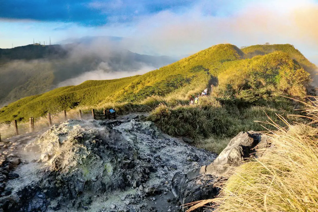
Yangmingshan National Park is a mountainous area in Taipei and New Taipei, known for its volcanic activity, hiking trails, wildlife, waterfalls, hot springs, and sulfur vents. It is definitely worth a stop on your trip to Taipei.
Historical Background: The area known as Yangmingshan now was formed by volcanoes about 700,000 years ago, forming many mountains about 1000 meters or less in northwestern Taiwan. The park still features active volcanoes, vents, and hot springs. The original name of the area was Caoshan (grass mountain 草山). During the Qing Dynasty, the area was used to harvest sulfur, and many of the hills were burned to help catch sulfur thieves, Qingtiangang likely being one of these areas. Sulfur mining was started in the Qing Dynasty by a British mining company that first obtained the rights to mine here in 1897. In 1927 during the Japanese era, Yangmingshan was made as the first national park in Taiwan, then known as Datunshan National Park Association. The area around Qingtiangang to Lengshuikeng was made into a ranch for water buffalo, and grass from Japan was planted here for them to graze. In 1950 after the ROC took Taiwan, Chiang Kai-shek renamed the park after the philosopher Wang Yangming, and called the area Yangmingshan. The KMT kept the ranch at Qingtiangang and continued to maintain it. They also built bunkers here and kept a garrison of troops. In 1985, after resolving many land disputes, Yangmingshan National Park was officially designated as a national park in the ROC era. Due to its easy accessibility from Taipei and many natural attractions, it is one of the most popular tourist destinations in Taipei City. Most visitors come on weekends, and it has parking lots and visitor's centers throughout the park. Hours: The visitor's centers are open from 9 AM to 4:30 PM. However you can visit the park 24/7. Price: Free entrance into the park (car parking 30-50 NT, scooter parking 20 NT) You can book tours to Yangmingshan on TripAdvisor here, Klook here, or KKday here or here. Tours: You can check out tours to Yangmingshan such as a One-day Yangmingshan NP Beitou Hot Spring Park and Tamsui Tour Package, Beitou and Yangmingshan Day Tour from Taipei, One Day Hike around Yangmingshan, or Private Yangmingshan Volcano Tour and more on TripAdvisor here, Klook here, or KKday here. When to Go: Silver Grass Season: Mang Grass season goes from September to November. During this time you will be able to see silvery grass all over the mountain tops around the park. Cherry Blossom Season: Cherry blossoms can be seen in the park from February to late March. Snowfall: Once every few years it can snow here from December to February. The snow usually only lasts a day or two and melts away quickly. Best Weather: In my opinion, the best weather is in the summer when constant rain makes the air cleaner, and summer mornings are usually clear. Be sure to start hiking in the morning for the best views and sunshine, as afternoon thundershowers are common. Hotels in Taipei: High end: We have stayed at and recommend the Yuanshan Grand Hotel, once the tallest building in Taiwan and still the most grand (book on Booking.com here, Tripadvisor here, or Agoda here). We have also stayed at and recommend the Grand Hyatt (book on Booking.com here, Tripadvisor here, Agoda here, or Hotels.com here), Marriot (book on Booking.com here, Tripadvisor here, Agoda here, or Hotels.com here), Sheraton (book on Booking.com here, Tripadvisor here, Agoda here, or Hotels.com here), Shangri-la (book on Booking.com here, Tripadvisor here, Agoda here, or Hotels.com here), and Regent (book on Booking.com here, Tripadvisor here, Agoda here, or Hotels.com here), which are all very high quality hotels in the middle of Taipei City. We also recommend Fullon Hotel which has locations in Tamsui and Fulong near the beach (book on Booking.com here, Tripadvisor here, Agoda here, or Hotels.com here). Budget Hotels: We have stayed at and also recommend Fu Chang Hotel in Ximending, which is within walking distance of Ximending shopping district (book on Booking.com here, Tripadvisor here, or Agoda here). We have also stayed at and recommend Hai Xia Your Home which is right in front of Fulong Beach (book on Booking.com here, Tripadvisor here, Agoda here, or Hotels.com here). Looking for a hotel? We recommend booking through Booking.com here, which provides the best quality selection of accommodation in Taiwan. Find out where to stay in our Taiwan hotels guide or search for the best hotel deals in Taiwan here. How to get there: By Car/Scooter: From Taipei, take provincial highway 2A north to the park, where you can see the main attractions such as Zhuzihu, Qixingshan, Datunshan, Qingtiangang, etc. There are many parking lots, but car parking is limited on weekends and the number of cars allowed up the mountain is also limited. There is also paid scooter parking. On weekends this place can be packed, and cars can be backed up for up to an hour or more, so consider taking a scooter or bus. Looking for scooter rental in Taipei? Check out Qeeq here, Klook here, or KKday here to search for options. You can also check out our scooter rental guide here. If you are looking for car rentals, you can also search Qeeq here, Klook here, or KKday here. You can also check out our car rental guide here. By Bus: From Beitou MRT Station, Take Little Bus 19 (小19), or another bus to the park. You can book tickets to travel to Taipei via inter-city bus on Klook here. You can book tickets to Taipei via high speed rail (HSR) on Klook here or KKDay here. By Bicycle: Cycling is the best way to enjoy Taiwan's landscapes if you have the time and energy. Looking for bicycle rentals in Taiwan? You can search on KKday here and search for tours on Klook here. You can also check out our Taiwan cycling guide here. Map: See below for a map of places mentioned in this blog: 
Houwan Beach in Kenting is a small beach near the Aquarium. It features a short yellow sandy beach, as well as clear water that is relatively warm year round. In addition, the beach has sunshine for most of the year. Popular activities include surfing, swimming, and sunbathing. It has everything you would want from a Kenting beach but it is smaller and there are fewer people than other beaches.
Background: Houwan is a small fishing town in Kenting after which the beach is named. The name literally means "back bay" in Chinese. Kenting was first settled by Chinese farmers during the Qing Dynasty. The word Kenting comes from two words that mean cultivate (ken3 墾) and strong man (丁 ding1). During that time, a group of strong men (or Zhuang Ding 壯丁) came from Guangdong, who were basically Chinese pioneers of the area to cultivate the land, hence the area was named Kenting for them. The area was considered to be made into a park during the Japanese occupation due to it being the only tropical location in the Japanese Empire, but was never officially created. Kenting National Park was established in 1984 as the first national park in Taiwan after WWII. Kenting became a major vacation spot, becoming a center for hostels and hotels for travelers. Kenting is considered by many to have the best beaches in Taiwan. This is because of its fine white sand and year-round warm temperatures and sunshine (it is in the tropical part of Taiwan after all). Usually, this beach is free of people and crowds even on weekends. Hours: 24/7 Price: Free When to go: Summer! It's when the water is warmest and the sun is hottest. However there will be more people in summer, and there could be Typhoons. Spring and Fall are also good times to go, as there will be less visitors and cooler temperatures. Winter is an okay time to go as well, it will be warmer than the rest of Taiwan and the water will still be warm enough to swim in. How to get there: By Car/Scooter: Take Provincial highway 1 south to the bottom of Taiwan until it becomes Provincial highway 26. After that keep going past Checheng and then turn west onto Houwan Road until you reach the beach. There is free parking near the beach. Looking for scooter rental in Pingtung? Click here or here to search for options. You can also check out our Taiwan scooter rental guide here. If you are looking for car rentals, you can also search here. You can check out our car rental guide here. By Bus: Busses leave daily to Kenting from Zuoying HSR station, Kaohsiung Station, and Pingtung. Get off at Shanghouwan上後灣. You can book tickets to Pingtung via high speed rail (HSR) on Klook here or KKDay here, or book tickets via the normal train (TRA) on Klook here. You can book tickets to travel to Pingtung via inter-city bus on Klook here. By Plane: There are direct shuttle busses to Kenting from Kaohsing's Xiaogang (KHH) Airport. You can book cheap flights to Kinmen on Trip.com or CheapO Air. You can also search for cheap flights in Taiwan on Kiwi here. Accommodation: I have stayed at many hostels and hotels in Kenting, and even almost bought a house here. Some places that I have stayed at and can recommend are Nanwan Kiki (book on Agoda here, Booking.com here), a B&B next to Nanwan Bay, Kenting's most popular Beach. There are also a few decent hotels near Kenting Street Night Market like Kenting Star Inn 888 (book on Agoda here, Klook here, Hotels.com here, Expedia here, or Booking.com here), or Kenting Dajianshan Hotel (book on Agoda here, Booking.com here, Hotels.com here, or Expedia here). You will notice that none of these hotels are five star resorts (I do not come to Kenting to waste my time at a resort, but you can still search Agoda, Booking.com, Hotels.com, or Expedia for those) but they are in my opinion the above have the best value for the money. Looking for a hotel? Find out where to stay in our Taiwan hotels guide or search for the best hotel deals in Taiwan here. We recommend booking through Agoda here, which provides the best quality selection of accommodation in Taiwan. Tours and Activities in Kenting: There are many activities available such as snorkeling, diving, SUPing, surfing, submarine riding, and river tracing. You can find more tours of Kenting on Klook here or KKday here. Map: Please see below: 
Xuhai Village is a place with amazing coastline in Mudan Township of Pingtung County. Due to its remote location, there are not many people and the landscape is mostly pristine. It may be the most beautiful stretch of coast on the main island of Taiwan.
Background: The area around Xuahi Village was originally named "Mudan Bay" because it is the site of the Mudan Incident in which nearly 100 shipwrecked Japanese sailors were massacred by local Paiwan tribespeople. The first settlers in the area arrived in the early 1900s during the Japanese era, and were mainly aboriginal people and Hakka people from other parts of Taiwan. In 1980 Xuhai Harbor was built to help the local economy and protect ships on the east coast during Typhoons. The population in the area is about half what it was in the 1980s as younger people have moved to big cities for better work opportunities. Even though there are over 450 registered households, only about 120 people regularly live here. Xuhai Village is also the start point of the Alangyi Trail 阿塱壹古道, which connects the east coast here from Pingtung to Taitung. Hours: 24/7 Price: Free Hotels: I have stayed at many hostels and hotels in Kenting, and even almost bought a house here. Some places that I have stayed at and can recommend are Nanwan Kiki (book on Agoda here, Booking.com here), a B&B next to Nanwan Bay, Kenting's most popular Beach. There are also a few decent hotels near Kenting Street Night Market like Kenting Star Inn 888 (book on Agoda here, Klook here, or Booking.com here), or Kenting Dajianshan Hotel (book on Agoda here or Booking.com here). You will notice that none of these hotels are five star resorts (I do not come to Kenting to waste my time at a resort, but you can still search Agoda or Booking.com) but they are in my opinion the above have the best value for the money. Looking for a hotel? Find out where to stay in our Taiwan hotels guide or search for the best hotel deals in Taiwan here. We recommend booking through Agoda here, which provides the best quality selection of accommodation in Taiwan. Tours and Activities in Pingtung: There are many activities available in Kenting, such as snorkeling, diving, SUPing, surfing, submarine riding, and river tracing. You can find more tours of Kenting on Klook here or KKday here. How to get there: By Bus: You can take bus 304 or 304A to Gangzai Nei station, and the sand dunes are about a half hour walk away. You can book tickets to travel to Pingtung via inter-city bus on Klook here. By Car/Scooter: Take County Highway 200 to Jiupeng in Pingtung. The sand dunes are very big and obvious along the coast. Looking for scooter rental in Pingtung? Click here or here to search for options. If you are looking for car rentals, you can also search here. By Bicycle: Cycling is the best way to enjoy Taiwan's landscapes if you have the time and energy. Looking for bicycle rentals in Taiwan? You can search on KKday here and search for tours on Klook here. You can also check out our Taiwan cycling guide here. Map: See below: 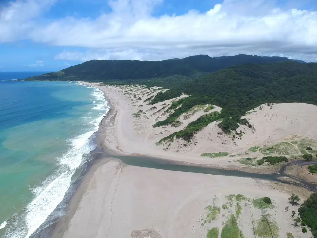
The Jiupeng Desert (aka Jioupeng Desert 九棚大沙漠 or Gangzhi Desert 港仔大沙漠) is a row of sand dunes along the coastline near Jiupeng Village, Manzhou Township, Pingtung County, and are the largest sand dunes in Taiwan. The area is not actually a desert but is formed from strong northeast winds along the coast, creating large dunes of sand despite the fact that Taiwan is a wet, tropical island.
Background: The area around Jiupeng Village was named because of nine villages in the area. The first settlers in the area arrived in the early 1900s during the Japanese era. The population in the area is about half what it was in the 1980s as younger people have moved to big cities for better work opportunities. Even though there are over 300 registered households, only about 100 people regularly live here. The sand dunes have become a popular spot for ATVing and off-roading, however some accidents and liability issues have hampered the industry. Usually you will not see many people here because the area is so remote. Hours: 24/7 Price: Free Where to stay: Looking for a hotel? Find out where to stay in our Taiwan hotels guide or search for the best hotel deals in Taiwan here. We recommend booking through Agoda here, which provides the best quality selection of accommodation in Taiwan. I have stayed at many hostels and hotels in Pingtung, and even almost bought a house here. Some places that I have stayed at and can recommend are Nanwan Kiki (book on Agoda here, Booking.com here), a B&B next to Nanwan Bay, Kenting's most popular Beach. There are also a few decent hotels near Kenting Street Night Market like Kenting Star Inn 888 (book on Agoda here, Klook here, or Booking.com here), or Kenting Dajianshan Hotel (book on Agoda here or Booking.com here). You will notice that none of these hotels are five star resorts (I do not come to Kenting to waste my time at a resort, but you can still search Agoda, Booking.com, or Klook here for those) but they are in my opinion the above have the best value for the money. Tours and Activities in Pingtung: There are many activities available in Kenting, such as Riding ATVs (four wheeling) on the beach snorkeling, diving, SUPing, surfing, submarine riding, and river tracing. You can find more tours of Kenting on Klook here or KKday here. How to get there: By Bus: You can take bus 304 or 304A to Gangzai Nei station, and the sand dunes are about a half hour walk away. You can book tickets to travel to Pingtung via inter-city bus on Klook here. By Car/Scooter: Take County Highway 200 to Jiupeng in Pingtung. The sand dunes are very big and obvious along the coast. Looking for scooter rental in Pingtung? Click here or here to search for options. If you are looking for car rentals, you can also search Qeeq here, Klook here, or KKday here. You can also check out our car rental guide here. By Bicycle: Cycling is the best way to enjoy Taiwan's landscapes if you have the time and energy. Looking for bicycle rentals in Taiwan? You can search on KKday here and search for tours on Klook here. You can also check out our Taiwan cycling guide here. Map: See below: 
Nanren Fishing Harbor is known as the loneliest fishing harbor in Taiwan. It lies at the dead end of Nanren Road at the northern end of Kenting National Park, the end of the road along the east coast between it and Jialeshui. Here you can find pristine landscapes, an amazing shoreline, and more cows than people.
Background: The area around Jiupeng Village was named because of nine villages in the area. The first settlers in the area arrived in the early 1900s during the Japanese era. The population in the area is about half what it was in the 1980s as younger people have moved to big cities for better work opportunities. Even though there are over 300 registered households, only about 100 people regularly live here. Nanren Fishing Harbor currently lies in the northeast part of Kenting National Park, as part of the Nanren Nature Preserve, which includes Nanren Lake, a remote wetland area in the mountains of Nanren. Hours: 24/7 Price: Free Where to stay: Looking for a hotel? Find out where to stay in our Taiwan hotels guide or search for the best hotel deals in Taiwan here. We recommend booking through Agoda here, which provides the best quality selection of accommodation in Taiwan. I have stayed at many hostels and hotels in Pingtung, and even almost bought a house here. Some places that I have stayed at and can recommend are Nanwan Kiki (book on Agoda here, Booking.com here), a B&B next to Nanwan Bay, Kenting's most popular Beach. There are also a few decent hotels near Kenting Street Night Market like Kenting Star Inn 888 (book on Agoda here, Klook here, or Booking.com here), or Kenting Dajianshan Hotel (book on Agoda here or Booking.com here). You will notice that none of these hotels are five star resorts (I do not come to Kenting to waste my time at a resort, but you can still search Agoda, Booking.com, or Klook here for those) but they are in my opinion the above have the best value for the money. Tours and Activities in Pingtung: There are many activities available in Kenting, such as snorkeling, diving, SUPing, surfing, submarine riding, and river tracing. You can find more tours of Kenting on Klook here or KKday here. How to get there: By Bus: The nearest bus stop is at Jiupeng Village via bus 304A, and it is about an hour walk (5KM) to the fishing harbor. You can book tickets to travel to Pingtung via inter-city bus on Klook here. By Car/Scooter: Take Couny Highway 200 to Jiupeng in Pingtung, then turn right onto Nanren Road. The fishing harbor is at the very end of the road. Looking for scooter rental in Pingtung? Click here or here to search for options. If you are looking for car rentals, you can also search Qeeq here, Klook here, or KKday here. You can also check out our car rental guide here. By Bicycle: Cycling is the best way to enjoy Taiwan's landscapes if you have the time and energy. Looking for bicycle rentals in Taiwan? You can search on KKday here and search for tours on Klook here. You can also check out our Taiwan cycling guide here. Map: See below: 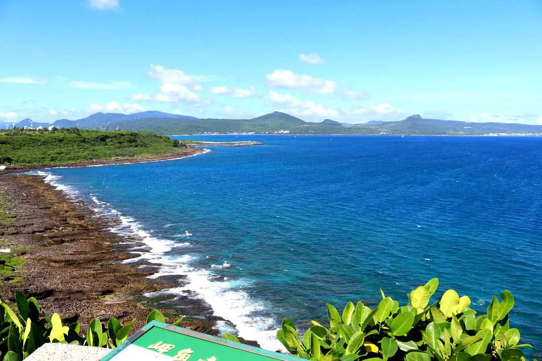
Maobitou Park is a coral and limestone cliff area with viewing platform that offers amazing panoramic views of the Hengchun Peninsula. There are also many interesting rock formations such as a rock that looks like a cat, as well as plants and wildlife. You should definitely stop by on your next trip to Kenting.
Background: Maobitou is the dividing line between the Taiwan Strait and the Bashi Channel in the Pacific Ocean. There is one prominent rock here that looked like a cat to local residents, hence the name of the area Maobitou 貓鼻頭, literally meaning cat rock. After uplift of the Eurasian Plate due to Collision with the Pacific plate, the rocks here have been thrust up from the sea over thousands of years. Now that they are exposed to wind and rain, the rocks here have taken on odd shapes and made giant holes and crevices. The water between Maobitou and Houshanbi Harbor is clear and full of sea life, and is one of the most diverse environments in Taiwan. Kenting was first settled by Chinese during the Qing Dynasty. The word Kenting comes from two words that mean cultivate (ken3 墾) and strong man (丁 ding1). During that time, a group of strong men (or Zhuang Ding 壯丁) came from Guangdong, who were basically Chinese pioneers of the area to cultivate the land, hence the area was named Kenting for them. The area was considered to be made into a park during the Japanese occupation due to it being the only tropical location in the Japanese Empire, but was never officially created. Kenting National Park was established in 1984 as the first national park in Taiwan after WWII. Kenting became a major vacation spot, becoming a center for hostels and hotels for travelers. Kenting is considered by many to have the best beaches in Taiwan. This is because of its fine white sand and year-round warm temperatures and sunshine (it is in the tropical part of Taiwan after all). Hours: 8 AM to 5 PM Price: 30 NT per person Parking: 40 NT for cars or 10 NT for scooters. When to go: Summer! It's when the water is warmest and the sun is hottest. However there will be more people in summer, and there could be Typhoons. Spring and Fall are also good times to go, as there will be less visitors and cooler temperatures. Winter is an okay time to go as well, it will be warmer than the rest of Taiwan and the water will still be warm enough to swim in. How to get there: By Car/Scooter: Take provincial highway 1 south to the bottom of Taiwan until it becomes provincial highway 26. After that turn right on highway 153 and keep left until you see the signs to Maobutou. Looking for scooter rental in Kenting? Click here or here to search for options. You can also check out our Taiwan scooter rental guide here. If you are looking for car rentals, you can also search here. You can also check out our car rental guide here. By Bus: Busses leave daily to Kenting from Zuoying HSR station, Kaohsiung Station, and Pingtung. From Hengchun Bus Station, you can take shuttle bus 102 to Maobitou Bus Stop. You can book tickets to Pingtung via high speed rail (HSR) on Klook here or KKDay here, or book tickets via the normal train (TRA) on Klook here. You can book tickets to travel to Pingtung via inter-city bus on Klook here. Accommodation: I have stayed at many hostels and hotels in Kenting, and even almost bought a house here. Some places that I have stayed at and can recommend are Nanwan Kiki (book on Agoda here, Booking.com here), a B&B next to Nanwan Bay, Kenting's most popular Beach. There are also a few decent hotels near Kenting Street Night Market like Kenting Star Inn 888 (book on Agoda here, Klook here, Hotels.com here, Expedia here, or Booking.com here), or Kenting Dajianshan Hotel (book on Agoda here, Booking.com here, Hotels.com here, or Expedia here). You will notice that none of these hotels are five star resorts (I do not come to Kenting to waste my time at a resort, but you can still search Agoda, Booking.com, Hotels.com, or Expedia for those) but they are in my opinion the above have the best value for the money. Looking for a hotel? Find out where to stay in our Taiwan hotels guide or search for the best hotel deals in Taiwan here. We recommend booking through Agoda here, which provides the best quality selection of accommodation in Taiwan. You can also book Wifi and SIM cards for Taiwan on Gigago here. Need travel insurance? Compare prices on Insubuy here. Tours and Activities in Kenting: There are many activities available such as snorkeling, diving, SUPing, surfing, submarine riding, and river tracing. You can find more tours of Kenting on Klook here or KKday here. Just to let you know, if you book using the links above, we get some commission at no cost to you, and you can help support our blog. You can click here to receive $5 USD on your first Klook purchase. Map: Please see below: 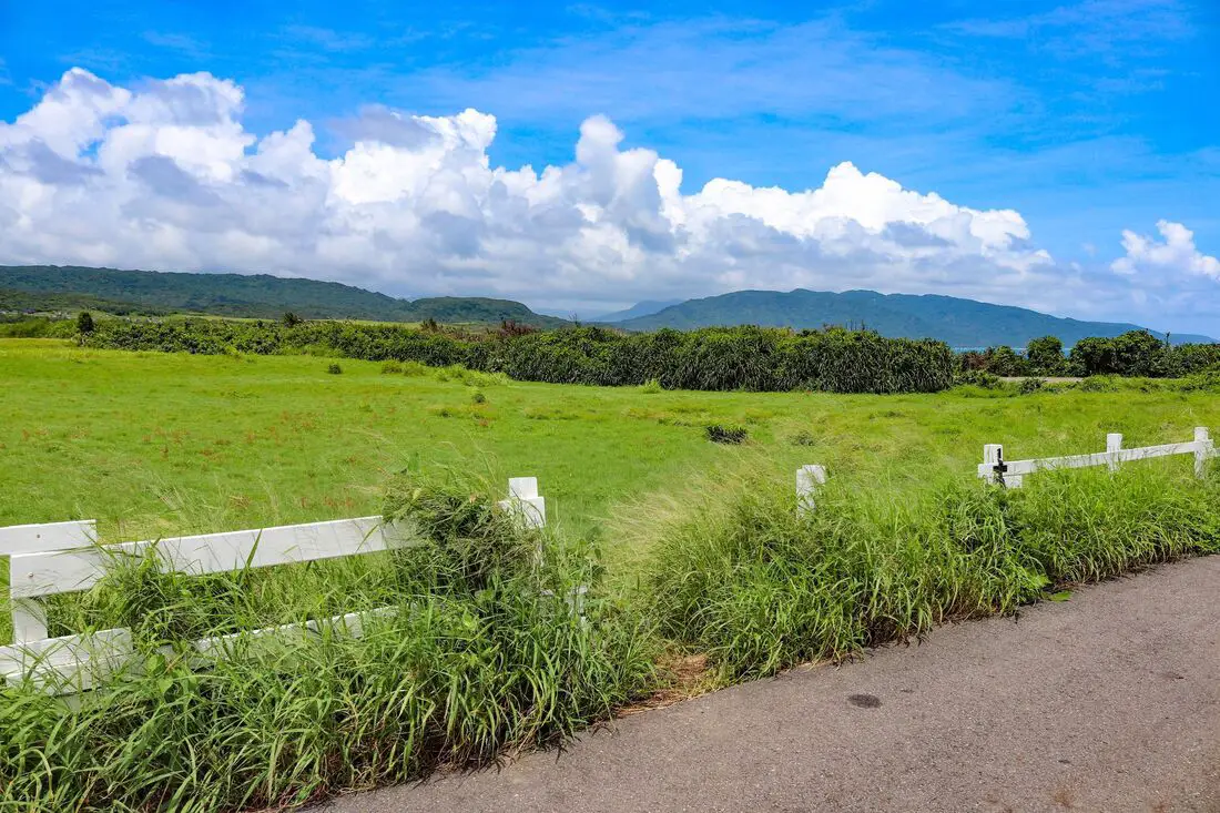
Shuiwaku is one of the most beautiful places in all of Kenting National Park. It features a large grassland that covers the southern tip of Taiwan. has great views of the shoreline on the east side of the peninsula, featuring a wind-cut sandy landscape and sea cliffs.
Background: Shuiwaku literally means "Water Frog Hole." It was first settled about 100 years ago by local residents (including both Han Chinese and those with aboriginal ancestry). They would fish for milkfish in the summer, and in the winter time when the weather was not good for fishing they planted crops here at the grasslands of Shuiwaku. One can also often see Sika deer grazing here. Kenting was first settled by Chinese during the Qing Dynasty. The word Kenting comes from two words that mean cultivate (ken3 墾) and strong man (丁 ding1). During that time, a group of strong men (or Zhuang Ding 壯丁) came from Guangdong, who were basically Chinese pioneers of the area to cultivate the land, hence the area was named Kenting for them. The area was considered to be made into a park during the Japanese occupation due to it being the only tropical location in the Japanese Empire, but was never officially created. During the Japanese Era, Nanwan was used as a whaling area and there were a few fishing villages here. Kenting National Park was established in 1984 as the first national park in Taiwan after WWII. Kenting became a major vacation spot, becoming a center for hostels and hotels for travelers. Hours: 24/7 Price: Free How to get there: By car/scooter: Take provincial highway 26 on the east side of Kenting until you come to Shuiwaku on the left side of the road. There is parking on the side of the road. Looking for scooter rental in Kenting? Click here or here to search for options. You can also check out our Taiwan scooter rental guide here. If you are looking for car rentals, you can also search here. You can also check out our car rental guide here. By bus: From Hengchun, take bus 8249 to Shuiwaku bus stop. You can book tickets to Pingtung via high speed rail (HSR) on Klook here or KKDay here, or book tickets via the normal train (TRA) on Klook here. You can book tickets to travel to Pingtung via inter-city bus on Klook here. Accommodation: I have stayed at many hostels and hotels in Kenting, and even almost bought a house here. Some places that I have stayed at and can recommend are Nanwan Kiki (book on Agoda here, Booking.com here), a B&B next to Nanwan Bay, Kenting's most popular Beach. There are also a few decent hotels near Kenting Street Night Market like Kenting Star Inn 888 (book on Agoda here, Klook here, Hotels.com here, Expedia here, or Booking.com here), or Kenting Dajianshan Hotel (book on Agoda here, Booking.com here, Hotels.com here, or Expedia here). You will notice that none of these hotels are five star resorts (I do not come to Kenting to waste my time at a resort, but you can still search Agoda, Booking.com, Hotels.com, or Expedia for those) but they are in my opinion the above have the best value for the money. Looking for a hotel? Find out where to stay in our Taiwan hotels guide or search for the best hotel deals in Taiwan here. We recommend booking through Agoda here, which provides the best quality selection of accommodation in Taiwan. You can also book Wifi and SIM cards for Taiwan on Gigago here. Need travel insurance? Compare prices on Insubuy here. Tours and Activities in Kenting: There are many activities available such as snorkeling, diving, SUPing, surfing, submarine riding, and river tracing. You can find more tours of Kenting on Klook here or KKday here. Just to let you know, if you book using the links above, we get some commission at no cost to you, and you can help support our blog. You can click here to receive $5 USD on your first Klook purchase. Map: Please see below: 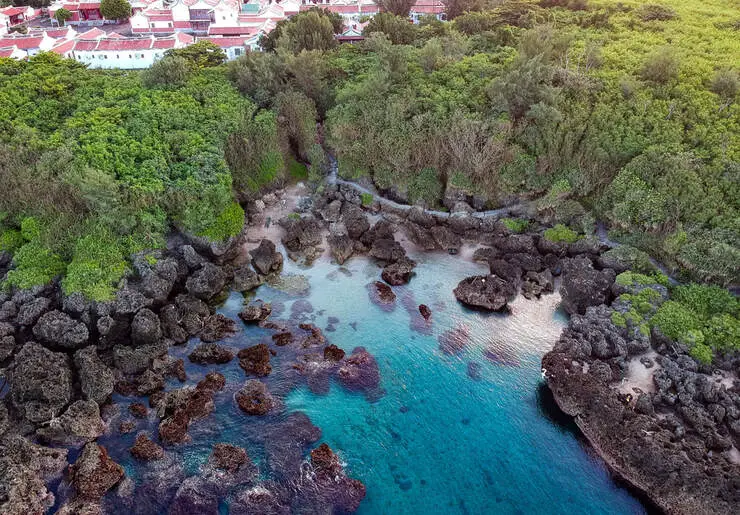
Lovers Beach is a small secret beach behind the Youth Activity Center in Kenting. It is small but usually free of crowds, and has calm, clear water. If you have time, you should check out this secret beach paradise.
Background: Lovers beach is a very small coral beach. The sand here is mostly rocky, but the water is clear. There is also a place to wash your feet nearby. The Youth Activity Center is the largest of its kind in Taiwan, and offers accommodation in the form of traditional Min style houses. There is also a restaurant on the site. If you book a room here you do not have to pay the price of admission. The entrance to the park also features hiking trails to Frog Rock and the surrounding area. Kenting was first settled by Chinese during the Qing Dynasty. The word Kenting comes from two words that mean cultivate (ken3 墾) and strong man (丁 ding1). During that time, a group of strong men (or Zhuang Ding 壯丁) came from Guangdong, who were basically Chinese pioneers of the area to cultivate the land, hence the area was named Kenting for them. The area was considered to be made into a park during the Japanese occupation due to it being the only tropical location in the Japanese Empire, but was never officially created. Kenting National Park was established in 1984 as the first national park in Taiwan after WWII. Kenting became a major vacation spot, becoming a center for hostels and hotels for travelers. Kenting is considered by many to have the best beaches in Taiwan. This is because of its fine white sand and year-round warm temperatures and sunshine (it is in the tropical part of Taiwan after all). Hours: 6:30 AM - 5 PM Price: Entrance fee: 50 NT per person Parking: 50 NT per car When to go: Summer! It's when the water is warmest and the sun is hottest. However there will be more people in summer, and there could be Typhoons. Spring and Fall are also good times to go, as there will be less visitors and cooler temperatures. Winter is an okay time to go as well, it will be warmer than the rest of Taiwan and the water will still be warm enough to swim in. How to get there: By Car/Scooter: Take provincial highway 1 south to the bottom of Taiwan until it becomes provincial highway 26. After that keep going past Kenting Street. There is paid parking inside the youth activity center. Looking for scooter rental in Kenting? Click here or here to search for options. You can also check out our Taiwan scooter rental guide here. If you are looking for car rentals, you can also search here. You can check out our car rental guide here. By Bus: Busses leave daily to Kenting from Zuoying HSR station, Kaohsiung Station, and Pingtung. Get off at the Xiaowan Beach stop (小灣). You can book tickets to Pingtung via high speed rail (HSR) on Klook here or KKDay here, or book tickets via the normal train (TRA) on Klook here. You can book tickets to travel to Pingtung via inter-city bus on Klook here. Accommodation: I have stayed at many hostels and hotels in Kenting, and even almost bought a house here. Some places that I have stayed at and can recommend are Nanwan Kiki (book on Agoda here, Booking.com here), a B&B next to Nanwan Bay, Kenting's most popular Beach. There are also a few decent hotels near Kenting Street Night Market like Kenting Star Inn 888 (book on Agoda here, Klook here, Hotels.com here, Expedia here, or Booking.com here), or Kenting Dajianshan Hotel (book on Agoda here, Booking.com here, Hotels.com here, or Expedia here). You will notice that none of these hotels are five star resorts (I do not come to Kenting to waste my time at a resort, but you can still search Agoda, Booking.com, Hotels.com, or Expedia for those) but they are in my opinion the above have the best value for the money. Looking for a hotel? Find out where to stay in our Taiwan hotels guide or search for the best hotel deals in Taiwan here. We recommend booking through Agoda here, which provides the best quality selection of accommodation in Taiwan. You can also book Wifi and SIM cards for Taiwan on Gigago here. Need travel insurance? Compare prices on Insubuy here. Tours and Activities in Kenting: There are many activities available such as snorkeling, diving, SUPing, surfing, submarine riding, and river tracing. You can find more tours of Kenting on Klook here or KKday here. Just to let you know, if you book using the links above, we get some commission at no cost to you, and you can help support our blog. You can click here to receive $5 USD on your first Klook purchase. Map: Please see below: 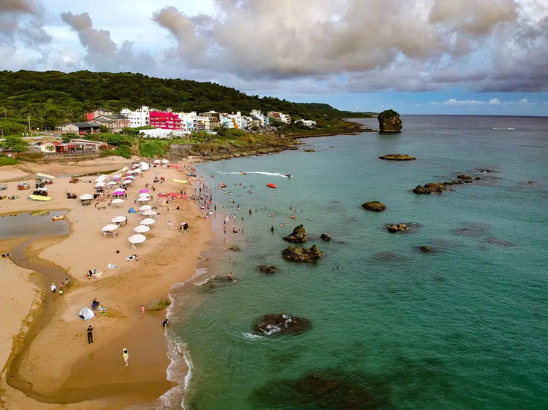
Sail Rock Beach in Kenting is a small beach near Sail Rock, a large piece of coral rock that broke off the mainland. It features short yellow sandy beach, as well as clear water that is relatively warm year round. In addition, the beach has sunshine for most of the year. Popular activities include jet skiing, water skiing, surfing, swimming, and sunbathing. It has everything you would want from a Kenting beach but it is smaller and there are less people than Nanwan Beach.
Background: Sail Rock is 18 meters tall, and was formed with the upheavel of the Taiwanese mainland, until it broke off from the main limestone shelf that forms the Hengchun Peninsula. Its name comes from its shape which looks similar to a ship's sail. Kenting was first settled by Chinese during the Qing Dynasty. The word Kenting comes from two words that mean cultivate (ken3 墾) and strong man (丁 ding1). During that time, a group of strong men (or Zhuang Ding 壯丁) came from Guangdong, who were basically Chinese pioneers of the area to cultivate the land, hence the area was named Kenting for them. The area was considered to be made into a park during the Japanese occupation due to it being the only tropical location in the Japanese Empire, but was never officially created. Kenting National Park was established in 1984 as the first national park in Taiwan after WWII. Kenting became a major vacation spot, becoming a center for hostels and hotels for travelers. Kenting is considered by many to have the best beaches in Taiwan. This is because of its fine white sand and year-round warm temperatures and sunshine (it is in the tropical part of Taiwan after all). The facilities at Sail Rock include showers, toilets, rentals, and a parking lot. Hours: Showers and Rentals: about 9 AM to 6 PM Price: Free When to go: Summer! It's when the water is warmest and the sun is hottest. However there will be more people in summer, and there could be Typhoons. Spring and Fall are also good times to go, as there will be less visitors and cooler temperatures. Winter is an okay time to go as well, it will be warmer than the rest of Taiwan and the water will still be warm enough to swim in. How to get there: By Car/Scooter: Take provincial highway 1 south to the bottom of Taiwan until it becomes provincial highway 26. After that keep going past Hengchun into Kenting National Park. Continue past Kenting Street until you see sail rock on the shore. Looking for scooter rental in Pingtung? Click here or here to search for options. You can also check out our Taiwan scooter rental guide here. If you are looking for car rentals, you can also search here. You can check out our car rental guide here. By Bus: Busses leave daily to Kenting from Zuoying HSR station, Kaohsiung Station, and Pingtung. Get off at Middle Chuanfanshi stop (中船帆石). You can book tickets to Pingtung via high speed rail (HSR) on Klook here or KKDay here, or book tickets via the normal train (TRA) on Klook here. You can book tickets to travel to Pingtung via inter-city bus on Klook here. By Plane: There are direct shuttle busses to Kenting from Kaohsing's Xiaogang (KHH) Airport. You can book cheap flights to Kinmen on Trip.com or CheapO Air. You can also search for cheap flights in Taiwan on Kiwi here. Accommodation: I have stayed at many hostels and hotels in Kenting, and even almost bought a house here. Some places that I have stayed at and can recommend are Nanwan Kiki (book on Agoda here, Booking.com here), a B&B next to Nanwan Bay, Kenting's most popular Beach. There are also a few decent hotels near Kenting Street Night Market like Kenting Star Inn 888 (book on Agoda here, Klook here, Hotels.com here, Expedia here, or Booking.com here), or Kenting Dajianshan Hotel (book on Agoda here, Booking.com here, Hotels.com here, or Expedia here). You will notice that none of these hotels are five star resorts (I do not come to Kenting to waste my time at a resort, but you can still search Agoda, Booking.com, Hotels.com, or Expedia for those) but they are in my opinion the above have the best value for the money. Looking for a hotel? Find out where to stay in our Taiwan hotels guide or search for the best hotel deals in Taiwan here. We recommend booking through Agoda here, which provides the best quality selection of accommodation in Taiwan. You can also book Wifi and SIM cards for Taiwan on Gigago here. Need travel insurance? Compare prices on Insubuy here. Tours and Activities in Kenting: There are many activities available such as snorkeling, diving, SUPing, surfing, submarine riding, and river tracing. You can find more tours of Kenting on Klook here or KKday here. Just to let you know, if you book using the links above, we get some commission at no cost to you, and you can help support our blog. You can click here to receive $5 USD on your first Klook purchase. Map: Please see below: 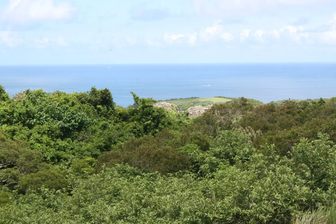
Sheding Nature Park is a nice hike that offers amazing views of Taiwan's Southern and East Coast. You can also enjoy tropical forests with gaping coral rocks and crevasses everywhere. It is a nice place for a short hike to enjoy nature and the scenery around Kenting.
Background: Sheding Park is not large but there are over 329 different kinds of plants here and over 50 different kinds of butterflies alone. The northeast wind here combined with coral rocks makes for a unique wind swept and rocky forest environment. There are over 50 limestone caves in this small park alone. Kenting was first settled by Chinese during the Qing Dynasty. The word Kenting comes from twp words that mean cultivate (ken3 墾) and strong man (丁 ding1). During that time, a group of strong men (or Zhuang Ding 壯丁) came from Guangdong, who were basically Chinese pionners of the area to cultivate the land, hence the area was named Kenting for them. The area was considered to be made into a park during the Japanese occupation due to it being the only tropical location in the Japanese Empire, but was never officially created. Kenting National Park was established in 1984 as the first national park in Taiwan after WWII. Kenting became a major vacation spot, becoming a center for hostels and hotels for travelers. Kenting is considered by many to have the best beaches in Taiwan. This is because of its fine white sand and year-round warm temperatures and sunshine (it is in the tropical part of Taiwan after all). Hours: 24/7 Price: Sheding Park 社頂自然公園: Free You can book discount tickets to Kenting's Forest Recreation Area on Klook here or KKday here. When to go: Summer! It's when the water is warmest and the sun is hottest. However there will be more people in summer, and there could be Typhoons. Spring and Fall are also good times to go, as there will be less visitors and cooler temperatures. Winter is an okay time to go as well, it will be warmer than the rest of Taiwan and the water will still be warm enough to swim in. How to get there: By Car/Scooter: Take provincial highway 1 south to the bottom of Taiwan until it becomes provincial highway 26. After that keep going past Hengchun into Kenting National Park. Looking for scooter rental in Kenting? Click here or here to search for options. You can also check out our Taiwan scooter rental guide here. If you are looking for car rentals, you can also search here. You can also check out our car rental guide here. By Bus: Busses leave daily to Kenting from Zuoying HSR station, Kaohsiung Station, and Pingtung. You can book tickets to Pingtung via high speed rail (HSR) on Klook here or KKDay here, or book tickets via the normal train (TRA) on Klook here. You can book tickets to travel to Pingtung via inter-city bus on Klook here. By Plane: There are direct shuttle busses to Kenting from Kaohsing's Xiaogang (KHH) Airport. You can book cheap flights to Kinmen on Trip.com or CheapO Air. You can also search for cheap flights in Taiwan on Kiwi here. Accommodation: I have stayed at many hostels and hotels in Kenting, and even almost bought a house here. Some places that I have stayed at and can recommend are Nanwan Kiki (book on Agoda here, Booking.com here), a B&B next to Nanwan Bay, Kenting's most popular Beach. There are also a few decent hotels near Kenting Street Night Market like Kenting Star Inn 888 (book on Agoda here, Klook here, Hotels.com here, Expedia here, or Booking.com here), or Kenting Dajianshan Hotel (book on Agoda here, Booking.com here, Hotels.com here, or Expedia here). You will notice that none of these hotels are five star resorts (I do not come to Kenting to waste my time at a resort, but you can still search Agoda, Booking.com, Hotels.com, or Expedia for those) but they are in my opinion the above have the best value for the money. Looking for a hotel? Find out where to stay in our Taiwan hotels guide or search for the best hotel deals in Taiwan here. We recommend booking through Agoda here, which provides the best quality selection of accommodation in Taiwan. You can also book Wifi and SIM cards for Taiwan on Gigago here. Need travel insurance? Compare prices on Insubuy here. Tours and Activities in Kenting: There are many activities available such as snorkeling, diving, SUPing, surfing, submarine riding, and river tracing. You can find more tours of Kenting on Klook here or KKday here. Just to let you know, if you book using the links above, we get some commission at no cost to you, and you can help support our blog. You can click here to receive $5 USD on your first Klook purchase. Map: Please see below: 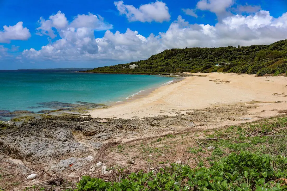
Shadao Beach in Kenting (aka Sand Island) is arguably the best beach in Taiwan, with excellent sand, warm clear water, pristine surroundings, warm temperatures year round, and no visitors. That's right, this beach is so great that it has been made into an environmentally protected area that no once can visit. Humans are banned.
Background: Shadao (literally meaning sand island) was originally named because the local residents thought the small bit of sand here looked like an island among the coral rocks. 98% of the sand on the beach is made of sea shells. Many of the sea shells that washed up on the beach were collected in the past and sent to other countries as precious ornaments. To protect the beach from disappearing, the government made the beach a protected area. Kenting was first settled by Chinese during the Qing Dynasty. The word Kenting comes from two words that mean cultivate (ken3 墾) and strong man (丁 ding1). During that time, a group of strong men (or Zhuang Ding 壯丁) came from Guangdong, who were basically Chinese pioneers of the area to cultivate the land, hence the area was named Kenting for them. The area was considered to be made into a park during the Japanese occupation due to it being the only tropical location in the Japanese Empire, but was never officially created. Kenting National Park was established in 1984 as the first national park in Taiwan after WWII. Kenting became a major vacation spot, becoming a center for hostels and hotels for travelers. Kenting is considered by many to have the best beaches in Taiwan. This is because of its fine white sand and year-round warm temperatures and sunshine (it is in the tropical part of Taiwan after all). Hours: 24/7 Price: Free When to go: Summer! It's when the water is warmest and the sun is hottest. However there will be more people in summer, and there could be Typhoons. Spring and Fall are also good times to go, as there will be less visitors and cooler temperatures. How to get there: By Car/Scooter: Take provincial highway 1 south to the bottom of Taiwan until it becomes provincial highway 26. After that keep going past Kenting Street and on to Shadao. The parking for Shadao is on the ocean side of the road. Looking for scooter rental in Pingtung? Click here or here to search for options. If you are looking for car rentals, you can also search here. By Bus: Busses leave daily to Kenting from Zuoying HSR station, Kaohsiung Station, and Pingtung. Get off at the Shadao bus stop (砂島). You can book tickets to Pingtung via high speed rail (HSR) on Klook here or KKDay here, or book tickets via the normal train (TRA) on Klook here. You can book tickets to travel to Pingtung via inter-city bus on Klook here. Accommodation: Looking for a hotel? Find out where to stay in our Taiwan hotels guide or search for the best hotel deals in Taiwan here. We recommend booking through Agoda here, which provides the best quality selection of accommodation in Taiwan. I have stayed at many hostels and hotels in Kenting, and even almost bought a house here. Some places that I have stayed at and can recommend are Nanwan Kiki (book on Agoda here, Booking.com here), a B&B next to Nanwan Bay, Kenting's most popular Beach. There are also a few decent hotels near Kenting Street Night Market like Kenting Star Inn 888 (book on Agoda here, Klook here, Hotels.com here, Expedia here, or Booking.com here), or Kenting Dajianshan Hotel (book on Agoda here, Booking.com here, Hotels.com here, or Expedia here). You will notice that none of these hotels are five star resorts (I do not come to Kenting to waste my time at a resort, but you can still search Agoda, Booking.com, Hotels.com, or Expedia for those) but they are in my opinion the above have the best value for the money. You can also book Wifi and SIM cards for Taiwan on Gigago here. Tours and Activities in Kenting: There are many activities available such as snorkeling, diving, SUPing, surfing, submarine riding, and river tracing. You can find more tours of Kenting on Klook here or KKday here. Just to let you know, if you book using the links above, we get some commission at no cost to you, and you can help support our blog. You can click here to receive $5 USD on your first Klook purchase. Map: Please see below: 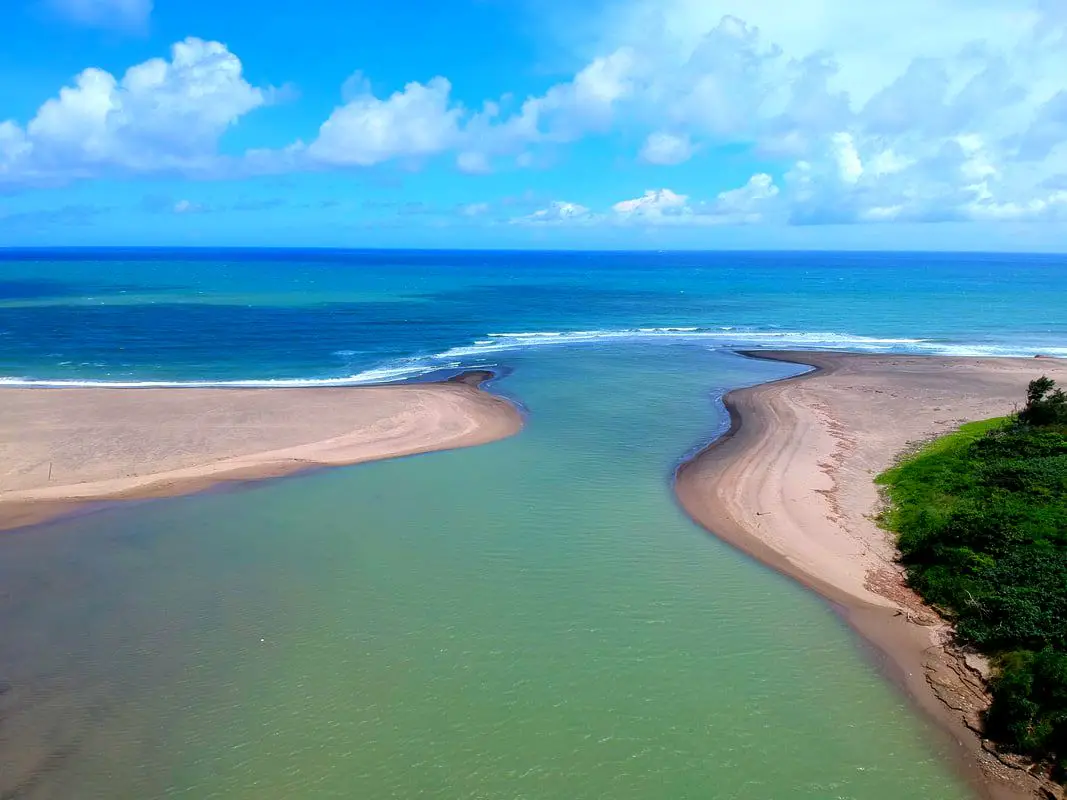
Gangkou Beach near Jialeshui Scenic Area in Kenting is one of the premier surfing beaches in Taiwan, with its most famous landmark being the Gangkou Suspension Bridge which leads to the Diaoqiao Wetland area. Popular activities here include surfing, kite surfing, swimming, and hiking. It is a must see on your trip to Kenting. Due to its location there are rarely crowds here even on weekends.
Background: The area around Gangkou was originally inhabited by the Paiwan Tribe. Afterward, Chinese settlers started moving in to farm the area, and it remains mainly a rural area to this day, with about one fourth of the population being indiginous people. Gangkou suspension bridge is190 meters long and less than 10 meters high. The bridge was built to give passage to locals who in early times had to cross the Gangkou River during winter when it was cold and windy in order to leave town. Gangkou Beach is usually free of crowds due to its location, and there are multiple surf board rentals nearby. Strong winds year round mean there are always constant large waves coming into the bay. Hours: 7:30 AM to 6:00 PM Price: Gangkou Suspension Bridge: 20 NT Parking: Free How to get there: By Bus: Take bus 8247 from Hengchun about half an hour to Gangkou Village. You can book tickets to Pingtung via high speed rail (HSR) on Klook here or KKDay here, or book tickets via the normal train (TRA) on Klook here. You can book tickets to travel to Pingtung via inter-city bus on Klook here. By Car/Scooter: Take Provincial highway 26 to its easternmost point to enter Gangkou Village. There is a parking lot near the suspension bridge with free parking. Looking for scooter rental in Pingtung? Click here or here to search for options. If you are looking for car rentals, you can also search here. Accommodation: I have stayed at many hostels and hotels in Kenting, and even almost bought a house here. Some places that I have stayed at and can recommend are Nanwan Kiki (book on Agoda here, Booking.com here), a B&B next to Nanwan Bay, Kenting's most popular Beach. There are also a few decent hotels near Kenting Street Night Market like Kenting Star Inn 888 (book on Agoda here, Klook here, Hotels.com here, Expedia here, or Booking.com here), or Kenting Dajianshan Hotel (book on Agoda here, Booking.com here, Hotels.com here, or Expedia here). You will notice that none of these hotels are five star resorts (I do not come to Kenting to waste my time at a resort, but you can still search Agoda, Booking.com, Hotels.com, or Expedia for those) but they are in my opinion the above have the best value for the money. Looking for a hotel? Find out where to stay in our Taiwan hotels guide or search for the best hotel deals in Taiwan here. We recommend booking through Agoda here, which provides the best quality selection of accommodation in Taiwan. You can also book Wifi and SIM cards for Taiwan on Gigago here. Tours and Activities in Kenting: There are many activities available such as snorkeling, diving, SUPing, surfing, submarine riding, and river tracing. You can find more tours of Kenting on Klook here or KKday here. Map: Please see below: 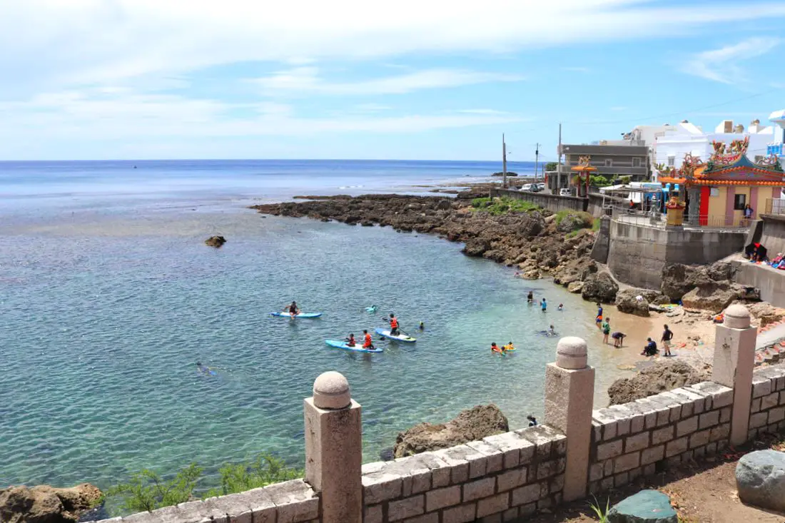
Wanlitong is one of the premier scuba diving and snorkeling spots in Taiwan, and sits inside Kenting National Park. The waters here are clear and full of coral and sea life. Other popular activities here are kayaking, SUPing and eating seafood.
Background: The waters of Wanlitong have one of the highest concentrations of coral and sea life in Kenting National Park. Underneath the water is its own underwater coral forest park. Kenting was first settled by Chinese during the Qing Dynasty. The word Kenting comes from two words that mean cultivate (ken3 墾) and strong man (丁 ding1). During that time, a group of strong men (or Zhuang Ding 壯丁) came from Guangdong, who were basically Chinese pioneers of the area to cultivate the land, hence the area was named Kenting for them. The area was considered to be made into a park during the Japanese occupation due to it being the only tropical location in the Japanese Empire, but was never officially created. Kenting National Park was established in 1984 as the first national park in Taiwan after WWII. Kenting became a major vacation spot, becoming a center for hostels and hotels for travelers. Kenting is considered by many to have the best beaches in Taiwan. This is because of its fine white sand and year-round warm temperatures and sunshine (it is in the tropical part of Taiwan after all). Hours: 24/7 Price: Free Snorkeling: 300 NT per hour (or thereabouts). You can book snorkeling and paddle boarding activities at Wanlitong on KKday here or on Klook here, here, or here. When to go: Summer! It's when the water is warmest and the sun is hottest. However there will be more people in summer, and there could be Typhoons. Spring and Fall are also good times to go, as there will be less visitors and cooler temperatures. Winter is an okay time to go as well, it will be warmer than the rest of Taiwan and the water will still be warm enough to swim in. How to get there: By Car/Scooter: Take provincial highway 1 south to the bottom of Taiwan until it becomes provincial highway 26. After you pass Hengchun, take a right onto Longguang Road and then turn right on Wanli Road. The village will be on your left. Looking for scooter rental in Pingtung? Click here or here to search for options. If you are looking for car rentals, you can also search here. By Bus: Busses leave daily to Kenting from Zuoying HSR station, Kaohsiung Station, and Pingtung. Get off at the Hengchun Bus Station, and then take the 101A to Xiaowanlitong bus station. You can book tickets to Pingtung via high speed rail (HSR) on Klook here or KKDay here, or book tickets via the normal train (TRA) on Klook here. You can book tickets to travel to Pingtung via inter-city bus on Klook here. By Plane: There are direct shuttle busses to Kenting from Kaohsing's Xiaogang (KHH) Airport. You can book cheap flights to Kinmen on Trip.com or CheapO Air. You can also search for cheap flights in Taiwan on Kiwi here. Accommodation: Looking for a hotel? Find out where to stay in our Taiwan hotels guide or search for the best hotel deals in Taiwan here. We recommend booking through Agoda here, which provides the best quality selection of accommodation in Taiwan. I have stayed at many hostels and hotels in Kenting, and even almost bought a house here. Some places that I have stayed at and can recommend are Nanwan Kiki (book on Agoda here, Booking.com here), a B&B next to Nanwan Bay, Kenting's most popular Beach. There are also a few decent hotels near Kenting Street Night Market like Kenting Star Inn 888 (book on Agoda here, Klook here, Hotels.com here, Expedia here, or Booking.com here), or Kenting Dajianshan Hotel (book on Agoda here, Booking.com here, Hotels.com here, or Expedia here). You will notice that none of these hotels are five star resorts (I do not come to Kenting to waste my time at a resort, but you can still search Agoda, Booking.com, Hotels.com, or Expedia for those) but they are in my opinion the above have the best value for the money. You can also book Wifi and SIM cards for Taiwan on Gigago here. Need travel insurance? Compare prices on Insubuy here. Tours and Activities in Kenting: There are many activities available such as snorkeling, diving, SUPing, surfing, submarine riding, and river tracing. You can find more tours of Kenting on Klook here or KKday here. Just to let you know, if you book using the links above, we get some commission at no cost to you, and you can help support our blog. You can click here to receive $5 USD on your first Klook purchase. Map: Please see below: 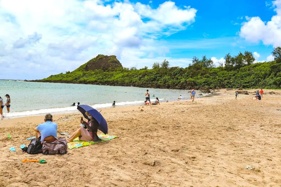
Xiaowan Beach in Kenting (aka Little Bay) features beautiful white sand and a long, flat beach, as well as clear water that is relatively warm year round. In addition, the beach has sunshine for most of the year. Popular activities include , surfing, swimming, and sunbathing. Located right next to the beach is Kenting Street, a great night market for snacking and tourist oriented shopping.
Background: Kenting was first settled by Chinese during the Qing Dynasty. The word Kenting comes from two words that mean cultivate (ken3 墾) and strong man (丁 ding1). During that time, a group of strong men (or Zhuang Ding 壯丁) came from Guangdong, who were basically Chinese pioneers of the area to cultivate the land, hence the area was named Kenting for them. The area was considered to be made into a park during the Japanese occupation due to it being the only tropical location in the Japanese Empire, but was never officially created. During the Japanese Era, Nanwan was used as a whaling area and there were a few fishing villages here. Kenting National Park was established in 1984 as the first national park in Taiwan after WWII. Kenting became a major vacation spot, becoming a center for hostels and hotels for travelers. Kenting is considered by many to have the best beaches in Taiwan. This is because of its fine white sand and year-round warm temperatures and sunshine (it is in the tropical part of Taiwan after all). The facilities at Xiaowan include changing rooms, showers, toilets, rentals, and a parking on the side of the road. Hours: Nanwan Beach: 8:30 AM to 9 PM Kenting Street Night Market: 6:30 PM - Midnight Price: Free Showers are paid. When to go: Summer! It's when the water is warmest and the sun is hottest. However there will be more people in summer, and there could be Typhoons. Spring and Fall are also good times to go, as there will be less visitors and cooler temperatures. Winter is an okay time to go as well, it will be warmer than the rest of Taiwan and the water will still be warm enough to swim in. How to get there: By Car/Scooter: Take provincial highway 1 south to the bottom of Taiwan until it becomes provincial highway 26. After that keep going past Kenting Street. There is parking next to the side of the road near the beach. Looking for scooter rental in Pingtung? Click here or here to search for options. If you are looking for car rentals, you can also search here. By Bus: Busses leave daily to Kenting from Zuoying HSR station, Kaohsiung Station, and Pingtung. Get off at the Xiaowan Beach stop (小灣). You can book tickets to Pingtung via high speed rail (HSR) on Klook here or KKDay here, or book tickets via the normal train (TRA) on Klook here. You can book tickets to travel to Pingtung via inter-city bus on Klook here. By Plane: There are direct shuttle busses to Kenting from Kaohsing's Xiaogang (KHH) Airport. You can book cheap flights to Kinmen on Trip.com or CheapO Air. You can also search for cheap flights in Taiwan on Kiwi here. Accommodation: The closest hotel to Xiaowan is the Ceasar Park Hotel, a five star resort which you can book on Agoda here, Booking.com here, Hotels.com here, or Expedia here. The hotel has a tunnel that leads straight to the beach, and it takes less than five minutes. I have stayed at many hostels and hotels in Kenting, and even almost bought a house here. Some places that I have stayed at and can recommend are Nanwan Kiki (book on Agoda here, Booking.com here), a B&B next to Nanwan Bay, Kenting's most popular Beach. There are also a few decent hotels near Kenting Street Night Market like Kenting Star Inn 888 (book on Agoda here, Klook here, Hotels.com here, Expedia here, or Booking.com here), or Kenting Dajianshan Hotel (book on Agoda here, Booking.com here, Hotels.com here, or Expedia here). You will notice that none of these hotels are five star resorts (I do not come to Kenting to waste my time at a resort, but you can still search Agoda, Booking.com, Hotels.com, or Expedia for those) but they are in my opinion the above have the best value for the money. Looking for a hotel? Find out where to stay in our Taiwan hotels guide or search for the best hotel deals in Taiwan here. We recommend booking through Agoda here, which provides the best quality selection of accommodation in Taiwan. You can also book Wifi and SIM cards for Taiwan on Gigago here. Tours and Activities in Kenting: There are many activities available such as snorkeling, diving, SUPing, surfing, submarine riding, and river tracing. You can find more tours of Kenting on Klook here or KKday here. Just to let you know, if you book using the links above, we get some commission at no cost to you, and you can help support our blog. You can click here to receive $5 USD on your first Klook purchase. Map: Please see below: 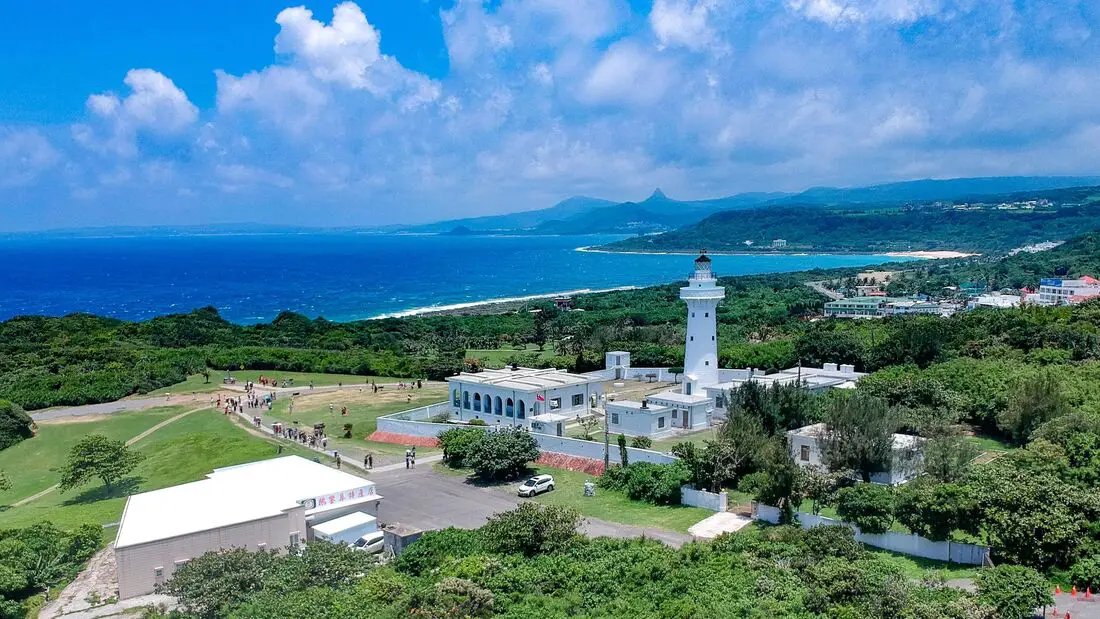
Eluanbi Lighthouse is a nice place to relax on the very southern tip of Taiwan in Kenting National Park. It is surrounded by grassy park and hiking trails through tropical forests with coral rocks. It is also within walking distance the most southern tip of the island of Taiwan on Cape Eluanbi. It is a must visit place for travelers to Taiwan.
Background: The lighthouse is named after Cape Eluanbi, the most southern point of Taiwan. The lighthouse is also know as the light of East Asia because it is the brightest lighthouse in Taiwan. It was constructed in 1883 during the Qing Dynasty. At the time, 500 soldiers were sent to protect the lighthouse against native Paiwan aboriginal tribesmen. The lighthouse served as a fort also. Later the lighthouse was damaged by Qing Officials as they lost control of the island, and the Empire of Japan later repaired the lighthouse. The lighthouse was then damaged by allied bombing raids. After WWII, the ROC rebuilt the lighthouse again, and it was opened to the public in 1982. Price: 60 NT per person You can book discount tickets to the lighthouse park on KKday here. Hours: Roughly 7 AM to 6 PM, varying depending on the season. When to go: Probably spring or fall are the best times to go, because during the summer it can get really hot and there is not much shade around. Winter is also colder and very windy. How to get there: By Bus: Take bus 9188 from Hengchun to Eluanbi Bus stop. It take about an hour to get there. You can book tickets to Pingtung via high speed rail (HSR) on Klook here or KKDay here, or book tickets via the normal train (TRA) on Klook here. You can book tickets to travel to Pingtung via inter-city bus on Klook here. By Car/Scooter: Drive south on provincial highway 26 until you reach Eluanbi Park. There is paid parking right next to the park entrance. Looking for scooter rental in Pingtung? Click here or here to search for options. If you are looking for car rentals, you can also search here. Accommodation: Looking for a hotel? Find out where to stay in our Taiwan hotels guide or search for the best hotel deals in Taiwan here. We recommend booking through Agoda here, which provides the best quality selection of accommodation in Taiwan. I have stayed at many hostels and hotels in Kenting, and even almost bought a house here. Some places that I have stayed at and can recommend are Nanwan Kiki (book on Agoda here, Booking.com here), a B&B next to Nanwan Bay, Kenting's most popular Beach. There are also a few decent hotels near Kenting Street Night Market like Kenting Star Inn 888 (book on Agoda here, Klook here, Hotels.com here, Expedia here, or Booking.com here), or Kenting Dajianshan Hotel (book on Agoda here, Booking.com here, Hotels.com here, or Expedia here). You will notice that none of these hotels are five star resorts (I do not come to Kenting to waste my time at a resort, but you can still search Agoda, Booking.com, Hotels.com, or Expedia for those) but they are in my opinion the above have the best value for the money. You can also book Wifi and SIM cards for Taiwan on Gigago here. Tours and Activities in Kenting: There are many activities available such as snorkeling, diving, SUPing, surfing, submarine riding, and river tracing. You can find more tours of Kenting on Klook here or KKday here. Just to let you know, if you book using the links above, we get some commission at no cost to you, and you can help support our blog. You can click here to receive $5 USD on your first Klook purchase. Map: Please see below: 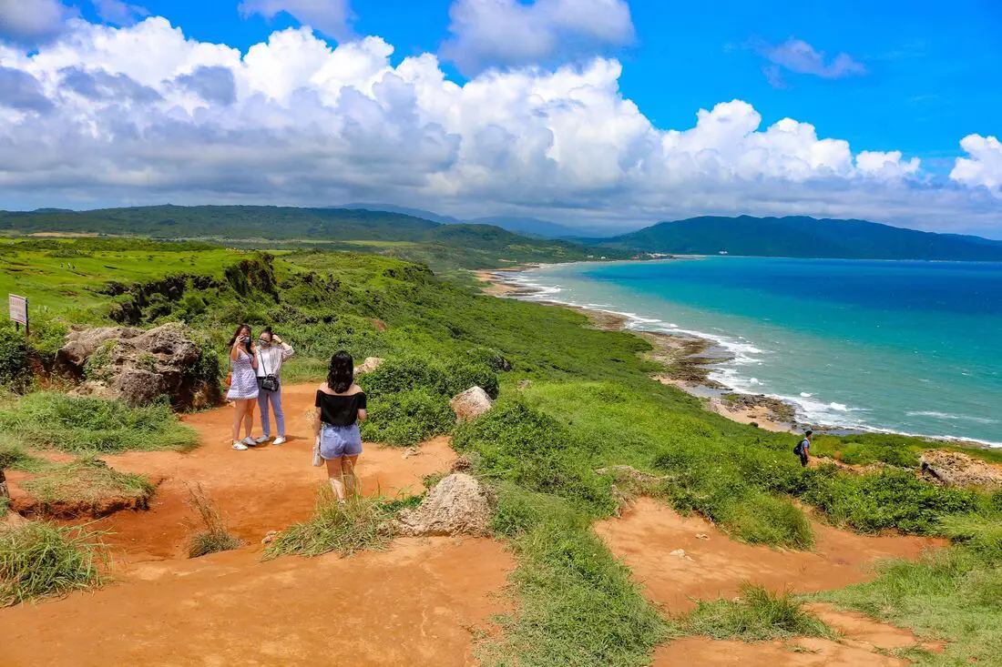
Longpan Park is one of the most beautiful places in all of Kenting National Park. It features a large grassland that covers the southern tip of Taiwan. has great views of the shoreline on the east side of the peninsula, featuring a wind-cut sandy landscape and sea cliffs.
Background: The area that covers Longpan Park originally a coral reef that was elevated above the shoreline. Due to the easily eroding limestone leftover after the rocks were thrust upward, it created a large plateau on the southern tip of Taiwan. The plateau has a long grassy plain that is a unique feature in Taiwan. Kenting was first settled by Chinese during the Qing Dynasty. The word Kenting comes from two words that mean cultivate (ken3 墾) and strong man (丁 ding1). During that time, a group of strong men (or Zhuang Ding 壯丁) came from Guangdong, who were basically Chinese pioneers of the area to cultivate the land, hence the area was named Kenting for them. The area was considered to be made into a park during the Japanese occupation due to it being the only tropical location in the Japanese Empire, but was never officially created. During the Japanese era Nanwan was used as a whaling area and there were a few fishing villages here. Kenting National Park was established in 1984 as the first national park in Taiwan after WWII. Kenting became a major vacation spot, becoming a center for hostels and hotels for travelers. Hours: 24/7 Price: Free How to get there: By car/scooter: Take provincial highway 26 on the east side of Kenting until you come to Longpan Park on the right side of the road. There is parking on the side of the road. Looking for scooter rental in Pingtung? Click here or here to search for options. If you are looking for car rentals, you can also search here. By bus: From Hengchun, take bus 8249 to Longpan Park bus stop. You can book tickets to Pingtung via high speed rail (HSR) on Klook here or KKDay here, or book tickets via the normal train (TRA) on Klook here. You can book tickets to travel to Pingtung via inter-city bus on Klook here. Accommodation: Looking for a hotel? Find out where to stay in our Taiwan hotels guide or search for the best hotel deals in Taiwan here. We recommend booking through Agoda here, which provides the best quality selection of accommodation in Taiwan. I have stayed at many hostels and hotels in Kenting, and even almost bought a house here. Some places that I have stayed at and can recommend are Nanwan Kiki (book on Agoda here, Booking.com here), a B&B next to Nanwan Bay, Kenting's most popular Beach. There are also a few decent hotels near Kenting Street Night Market like Kenting Star Inn 888 (book on Agoda here, Klook here, Hotels.com here, Expedia here, or Booking.com here), or Kenting Dajianshan Hotel (book on Agoda here, Booking.com here, Hotels.com here, or Expedia here). You will notice that none of these hotels are five star resorts (I do not come to Kenting to waste my time at a resort, but you can still search Agoda, Booking.com, Hotels.com, or Expedia for those) but they are in my opinion the above have the best value for the money. You can also book Wifi and SIM cards for Taiwan on Gigago here. Need travel insurance? Compare prices on Insubuy here. Tours and Activities in Kenting: There are many activities available such as snorkeling, diving, SUPing, surfing, submarine riding, and river tracing. You can find more tours of Kenting on Klook here or KKday here. Just to let you know, if you book using the links above, we get some commission at no cost to you, and you can help support our blog. You can click here to receive $5 USD on your first Klook purchase. Map: Please see below: 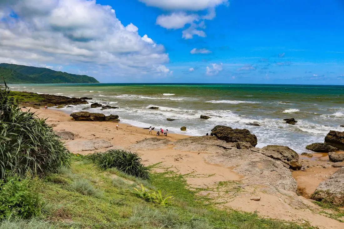
Manzhou Beach is a small sandy beach on the southeast coast of Kenting National Park. It features gold sand and warm year round temperatures. Seasonal winds also means there are usually waves here to surf on. Due to its remote location and lack of facilities, usually it is devoid of people.
Background: Manzhou Beach is a natural patch of sand among coral rocks on the southern tip of Manzhou Township. There is free parking here, but no showers, bathrooms, or other facilities. Because of the constant wind and large waves, usually you do not see many sunbathers or swimmers. Hours: 24/7 Price: Free How to get there: By car/scooter: Take provincial highway 26 on the east side of Kenting until you come to Manzhou on the side of the road. There is a large white pillar and small parking lot that is usually never full. Looking for scooter rental in Pingtung? Click here or here to search for options. If you are looking for car rentals, you can also search here. By bus: From Hengchun, take bus 8249 to Shuiwaku and then walk about 30 minutes on the side of the road to get there. You can book tickets to Pingtung via high speed rail (HSR) on Klook here or KKDay here, or book tickets via the normal train (TRA) on Klook here. You can book tickets to travel to Pingtung via inter-city bus on Klook here. Accommodation: I have stayed at many hostels and hotels in Kenting, and even almost bought a house here. Some places that I have stayed at and can recommend are Nanwan Kiki (book on Agoda here, Booking.com here), a B&B next to Nanwan Bay, Kenting's most popular Beach. There are also a few decent hotels near Kenting Street Night Market like Kenting Star Inn 888 (book on Agoda here, Klook here, Hotels.com here, Expedia here, or Booking.com here), or Kenting Dajianshan Hotel (book on Agoda here, Booking.com here, Hotels.com here, or Expedia here). You will notice that none of these hotels are five star resorts (I do not come to Kenting to waste my time at a resort, but you can still search Agoda, Booking.com, Hotels.com, or Expedia for those) but they are in my opinion the above have the best value for the money. Looking for a hotel? Find out where to stay in our Taiwan hotels guide or search for the best hotel deals in Taiwan here. We recommend booking through Agoda here, which provides the best quality selection of accommodation in Taiwan. You can also book Wifi and SIM cards for Taiwan on Gigago here. Need travel insurance? Compare prices on Insubuy here. Tours and Activities in Kenting: There are many activities available such as snorkeling, diving, SUPing, surfing, submarine riding, and river tracing. You can find more tours of Kenting on Klook here or KKday here. Just to let you know, if you book using the links above, we get some commission at no cost to you, and you can help support our blog. You can click here to receive $5 USD on your first Klook purchase. Map: Please see below: 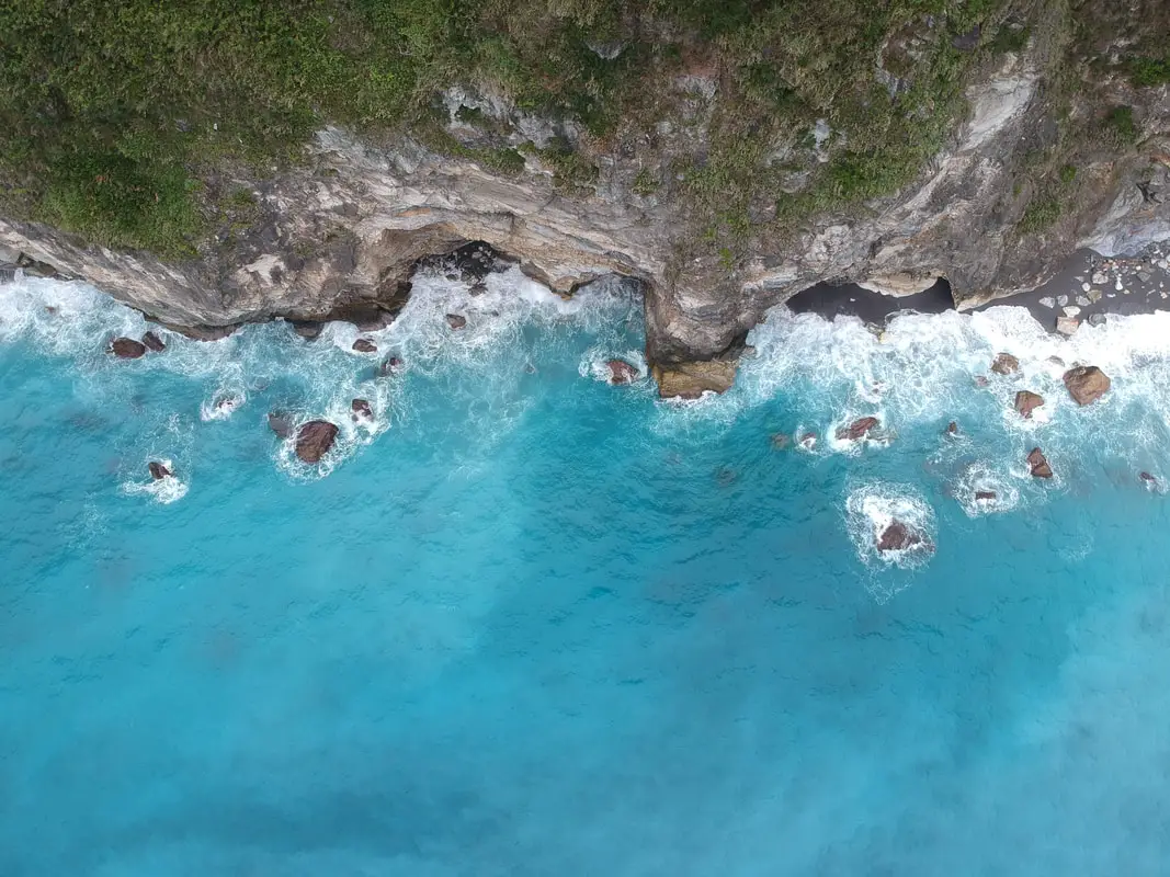
The Qingshui Cliffs in Taroko National Park on the coast of Hualien are some of the most spectacular geological features in the country, and the world. The tallest peak on the cliffs is 2,408 meters (7,900 feet) above sea level, and drops straight into the Pacific Ocean. It is a spectacular sight to behold.
Background: Taroko National Park is well known for its marble cliffs and canyons, and is also known as "The Marble Gorge." Millions of years ago, the rock we see today was sediment at the bottom of the Pacific Ocean, but oceanic and tectonic pressure turned it into limestone, and later into marble. Later the Eurasian plate was uplifted where Taiwan is today, and the cliffs were lifted out of the ocean. The cliffs are subject to constant erosion and rockslides are common. The cliffs are roughly 12 KM long and rise to over 2400 meters. They are a popular scenic stop along the Suhua highway that connects Yiland and Hualien. Hours: 24/7 Price: Free: When to visit? Hualien is great year round, but it can get a little hot in the summer, and Typhoon season and heavy rain season last from about May to October. If you are afraid of the heat and rain then you can visit during winter when the temperatures are mild and the climate is usually dryer. Where to stay? Most of the accommodation you will find is near the city center. If you only want to visit Hualien City and Taroko Gorge, you can consider booking a hotel near downtown, walking or cycling around the city, and taking a bus to Taroko Gorge. We have stayed at and recommend Dream Taiwan Homestay (Agoda / Booking.com / Expedia / Hotels.com), a high quality hostel for the money in downtown Hualien, Farglory Hotel (Agoda / Booking.com / Expedia / Hotels.com), right next to Farglory Ocean Park with amazing views of Hualien, and Goldenflower B&B (Agoda / Booking.com) in Yuli right next to Sixty Stone Mountain. You can find out where to stay in our Taiwan hotels guide or search for the best hotel deals in Taiwan here. You can also book Wifi and SIM cards for Taiwan on Gigago here. Need travel insurance? Compare prices on Insubuy here. How to get there: By Car/Scooter: From Hualien, Take highway 9 north until you reach the Qingshui Cliff lookout. There are actually a number of places to see the cliffs. Looking for a scooter rental in Hualien? You can search KKday here or Klook here to look for options. You can also check out our scooter rental guide here. If you are looking for car rentals in Hualien, you can also search Klook here or KKDay here. You can also check out our car rental guide here. By Bus: There is no public bus to the cliffs. You will have to rent a scooter or take a tour bus. Tours and Activities: You can book a SUP or kayak experience at Qingshui Cliffs and more on Klook here and KKday here. You can book tickets to travel to Hualien via inter-city bus on Klook here. Book tickets via the normal train (TRA) on Klook here. Map: See below: 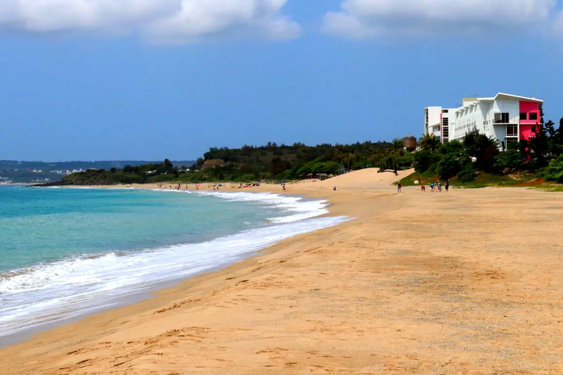
Kenting Dawan Beach (aka Kenting Beach Swimming Area) is a premier beach destination on the Taiwan mainland, and attracts a fair amount of visitors, especially those that stay at the Kenting Chateu Beach resort that sits right on the beach. It features beautiful yellow sand and the longest beach in Kenting. In addition, the beach is right next to Kenting Street Night Market, a great night market for snacking and tourist oriented shopping.
Background: Kenting was first settled by Chinese during theQing Dynasty. The word Kenting comes from twp words that mean cultivate (ken3 墾) and strong man (丁 ding1). During that time, a group of strong men (or Zhuang Ding 壯丁) came from Guangdong, who were basically Chinese pionners of the area to cultivate the land, hence the area was named Kenting for them. The area was considered to be made into a park during the Japanese occupation due to it being the only tropical location in the Japanese Empire, but was never officially created. During the Japanese era Nanwan was used as a whaling area and there were a few fishing villages here. Kenting National Park was established in 1984 as the first national park in Taiwan after WWII. Kenting became a major vacation spot, becoming a center for hostels and hotels for travelers. Kenting is considered by many to have the best beaches in Taiwan. This is because of its fine white sand and year-round warm temperatures and sunshine (it is in the tropical part of Taiwan after all). The facilities at Kenting Beach include a foot wash, and swimming is actually technically prohibited. Therefore usually you will not see many people on the beach. Hours: Kenting Beach: 24/7 Kenting Street Night Market: 6:30 PM - Midnight Price: Free When to go: Summer! It's when the water is warmest and the sun is hottest. However there will be more people in summer, and there could be Typhoons. Spring and Fall are also good times to go, as there will be less visitors and cooler temperatures. Winter is an okay time to go as well, it will be warmer than the rest of Taiwan and the water will still be warm enough to swim in. How to get there: By Car/Scooter: Take provincial highway 1 south to the bottom of Taiwan until it becomes provincial highway 26. After that keep going past Hengchun into Kenting National Park. The beach will be on your right as you pass the a 7-11. There is a parking lot next to the beach. Looking for scooter rental in Kenting? Click here or here to search for options. If you are looking for car rentals, you can also search here. By Bus: Busses leave daily to Kenting from Zuoying HSR station, Kaohsiung Station, and Pingtung. Get off at the Kenting Arch Stop (墾丁牌樓). You can book tickets to Kenting via high speed rail (HSR) on Klook here or KKDay here, or book tickets via the normal train (TRA) on Klook here. You can book tickets to travel to Kenting via inter-city bus on Klook here. By Plane: There are direct shuttle busses to Kenting from Kaohsing's Xiaogang (KHH) Airport. You can search for cheap flights in Taiwan here. You can also book Wifi and SIM cards for Taiwan on Gigago here. Accommodation: I have stayed at many hostels and hotels in Kenting, and even almost bought a house here. Some places that I have stayed at and can recommend are Nanwan Kiki (book on Agoda here), a B&B next to Nanwan Bay, Kenting's most popular Beach. There are also a few decent hotels near Kenting Street Night Market like Kenting Star Inn 888 (book on Agoda here or on Klook here), or Kenting Dajianshan Hotel (book on Agoda here). You will notice that none of these hotels are five star resorts (I do not come to Kenting to waste my time at a resort, but you can still search Agoda for those) but they are in my opinion the above have the best value for the money. Find out where to stay in our Taiwan hotels guide or search for the best hotel deals in Taiwan here. We recommend booking through Agoda here, which provides the best quality selection of accommodation in Taiwan. Tours and Activities in Kenting: There are many activities available in such as snorkeling, diving, SUPing, surfing, submarine riding, and river tracing in Kenting. You can find more tours of Kenting on Klook here or KKday here. Just to let you know, if you book using the links above, we get some commission at no cost to you, and you can help support our blog. You can click here to receive $5 USD on your first Klook purchase. Map: Please see below: 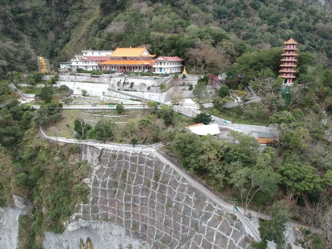
Tianxiang Recreation Area features the widest and most flat terraces within Taroko Gorge. Here you can find Xiangde Temple, Tianfeng Pagoda, Pudu Suspension Bridge, and Silks Place Taroko, which are all surrounded by amazing high canyons and beautiful deep river ravines. It is a must see spot inside Taroko Gorge.
Background: Taroko National Park is well known for its marble cliffs and canyons, and is also known as "The Marble Gorge." Millions of years ago, the rock we see today was sediment at the bottom of the Pacific Ocean, but oceanic and tectonic pressure turned it into limestone, and later into marble. Later the Eurasian plate was uplifted where Taiwan is today, and a gorge was cut out of the limestone thanks to the Liwu River. Taroko means "human being," from the Truku tribal language. Originally the Tupido Tribe settled in the area of what is now Tianxiang Taiti mesa. They built the Tupido Tribe Trail which was only 30 cm wide, and resided there until they were massacred by the Japanese in 1914. In 1917, the Japanese expanded the original trail made by the Tupido Tribe to 1.5 M and forced aboriginal tribesmen to carry goods along the trail to the east coast. This is now the Zhuilu Old Trail. Currently only 3km of the trail is open to the public. The Japanese created a national park in the Area in 1937, which was disestablished by the ROC in 1945, and then reenstated in as a national park in 1986. Tianxiang lies 455 meters above seas level, and lies at the convergence of the Dasha River and the Tazijili River, forming the Liwu River. Xiangde Temple was built in 1966 shortly after the central cross island highway was finished. It is a Buddhist monetary, and the area was chosen for it's quiet beauty. How to get there: By Car: From Taipei, Take National Highway 5 to Yilan and then drive on the Suhua Highway 9 to Hualien. A few miles before Hualien City, the gorge will be on your right. Tianxiang is 18 KM in. Looking for a scooter rental in Hualien? You can search KKday here or Klook here to look for options. You can also check out our scooter rental guide here. If you are looking for car rentals in Hualien, you can also search Klook here or KKDay here. You can also check out our car rental guide here. By Train: Take the train to Hualien station, and from there you can rent a scooter or car, or take a tour bus to the gorge, and then get off at Tianxiang. You can book tickets to travel to Hualien via inter-city bus on Klook here. Book tickets via the normal train (TRA) on Klook here. For more travel information see here. Where to stay? Most of the accommodation you will find is near the city center. If you only want to visit Hualien City and Taroko Gorge, you can consider booking a hotel near downtown, walking or cycling around the city, and taking a bus to Taroko Gorge. We have stayed at and recommend Dream Taiwan Homestay (Agoda / Booking.com / Expedia / Hotels.com), a high quality hostel for the money in downtown Hualien, Farglory Hotel (Agoda / Booking.com / Expedia / Hotels.com), right next to Farglory Ocean Park with amazing views of Hualien, and Goldenflower B&B (Agoda / Booking.com) in Yuli right next to Sixty Stone Mountain. You can find out where to stay in our Taiwan hotels guide or search for the best hotel deals in Taiwan here. You can also book Wifi and SIM cards for Taiwan on Gigago here. Need travel insurance? Compare prices on Insubuy here. Tours: You can find tours of Tianxiang on Klook here or KKday here. You can find more tours and activities in Hualien such as Surfing, Paragliding, SUP / Paddle Boarding, Kayaking, Canoeing, River Tracing, and much more on Klook here or KKday here. Hours: 24/7 Flying a Drone? Apply for a drone permit here. Price: Free! Map: Please see below: 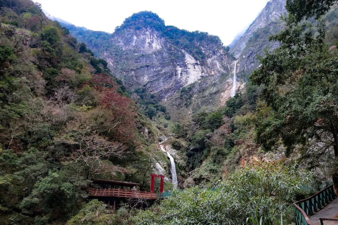
Baiyang Falls are a beautiful set of waterfalls in Taroko National Park. The trail is only 2 KM long and is flat and paved with no steps. It is an easy and relaxing way to enjoy some of the best scenery in the park.
Background: Taroko National Park is well known for its marble cliffs and canyons, and is also known as "The Marble Gorge." Millions of years ago, the rock we see today was sediment at the bottom of the Pacific Ocean, but oceanic and tectonic pressure turned it into limestone, and later into marble. Later the Eurasian plate was uplifted where Taiwan is today, and a gorge was cut out of the limestone thanks to the Liwu River. Taroko means "human being," from the Truku tribal language. Originally the Tupido Tribe settled in the area of what is now Tianxiang Taiti mesa. They built the Tupido Tribe Trail which was only 30 cm wide, and resided there until they were massacred by the Japanese in 1914. In 1917, the Japanese expanded the original trail made by the Tupido Tribe to 1.5 M and forced aboriginal tribesmen to carry goods along the trail to the east coast. This is now the Zhuilu Old Trail. Currently only 3km of the trail is open to the public. The Japanese created a national park in the Area in 1937, which was disestablished by the ROC in 1945, and then reinstated in as a national park in 1986. The road to Baiyang Waterfall was created by the Taipower Company in an effort to build a hydropower reservoir in Taroko Gorge. However the project was not completed, to protect the natural scenery in the area. The roads and tunnels left over from the project now make up the current trail, to what would normally be an arduous hike through impossible terrain. Baiyang Waterfall is 220 meters high, and the highest waterfall in Taiwan to fall off one sheer cliff. When to visit? Hualien is great year round, but it can get a little hot in the summer, and Typhoon season and heavy rain season last from about May to October. If you are afraid of the heat and rain then you can visit during winter when the temperatures are mild and the climate is usually dryer. Where to stay? Most of the accommodation you will find is near the city center. If you only want to visit Hualien City and Taroko Gorge, you can consider booking a hotel near downtown, walking or cycling around the city, and taking a bus to Taroko Gorge. We have stayed at and recommend Dream Taiwan Homestay (Agoda / Booking.com / Expedia / Hotels.com), a high quality hostel for the money in downtown Hualien, Farglory Hotel (Agoda / Booking.com / Expedia / Hotels.com), right next to Farglory Ocean Park with amazing views of Hualien, and Goldenflower B&B (Agoda / Booking.com) in Yuli right next to Sixty Stone Mountain. You can find out where to stay in our Taiwan hotels guide or search for the best hotel deals in Taiwan here. You can also book Wifi and SIM cards for Taiwan on Gigago here. Need travel insurance? Compare prices on Insubuy here. How to get there: By Car: From Taipei, Take National Highway 5 to Yilan and then drive on the Suhua Highway 9 to Hualien. A few miles before Hualien City, the gorge will be on your right. Keeping going until you reach the Baiyang Waterfall hike about 20 KM up the road. You can search KKday here or Klook here to look for options. You can also check out our scooter rental guide here. If you are looking for car rentals in Hualien, you can also search Klook here or KKDay here. You can also check out our car rental guide here. By Train: Take the train to Hualien station, and from there you can rent a scooter or car, or take a tour bus to the gorge, and get off at Baiyang Waterfall station. You can book tickets to travel to Hualien via inter-city bus on Klook here. Book tickets via the normal train (TRA) on Klook here. For more travel information see here. Tours: You can book a tour to Baiyang Falls on KKday here. Find more tours and activities in Hualien such as Surfing, Paragliding, SUP / Paddle Boarding, Kayaking, Canoeing, River Tracing, and much more on Klook here or KKday here. Hours: 24/7 Map: Please see below: 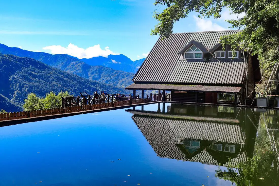
Wuling Farm is a recreational farm in the mountains of Taichung, Taiwan. It is one of the only places that you can spot the endangered Formosan Landlocked Salmon in the wild, and includes flowers, fruit trees, tea plantations, cherry blossoms, hikes, camping, waterfalls, and wildlife to enjoy. It is a great place to experience Taiwan's high mountain ecology.
Background: Originally the Qijia Valley where Wuling Farm sits was home to seven families of the Ayatal Tribe, and aboriginal peoples lived here starting over 4,000 years ago. The aboringal people were relocated to Sqoyaw Village in the 1950s. Wuling Farm was established in 1963 as a way to provide a living for retired KMT veterans. The farm's original purpose was to plant temperate fruit trees and vegetables. Starting in 1989, the farm began tourist acticites, such as building a campground, tea houses, gardens, hotels, and a tourist service center. The farm sits at about 2000 meters above sea level (6,561 feet). Website: https://lang.wuling-farm.com.tw/lang/index.php Price: 160 NT per person to enter 50 NT for cars 10 NT for scooters Accommodation: We recommend staying overnight because you will likely have to travel a long time to get here (4 hours from Taipei), and staying overnight lets you maximize your time here. You can book online for one of the following accommodation options: Wuling National Hostel (2,000 NT - 8,000 NTD per night) Wuling Hoya Resort (6,000 - 15,000 NTD per night) Wuling Campground (1,000 - 2200 NTD per night) Hours: 24/7 When to go: A popular time to go is in March-April when there are cherry blossoms. Also, it can get very cold in the winter. How to get there: By Car/Scooter: It is actually faster to travel to Wuling Farm from Taipei instead of downtown Taichung, even though technically the farm is in Taichung City. From Yilan, take provincial highway 7 through Datong Township and up the mountain until you reach Wuling Farm. By Bus: Taiwan Tour Bus and Lion Travel have busses that leave from Taipei and arrive 4 hours later. Map: Please see below: |
Author 作家I am an American expat who has extensive experience living, working, and traveling in Taiwan. In my day, I had to learn many things about Taiwan the hard way. But I have come to learn that Taiwan is one of the best places in the world for Foreigners to live. This blog does not represent the opinions of every foreigner in Taiwan. I am just trying to help others learn more about this beautiful country. Categories
|
 RSS Feed
