

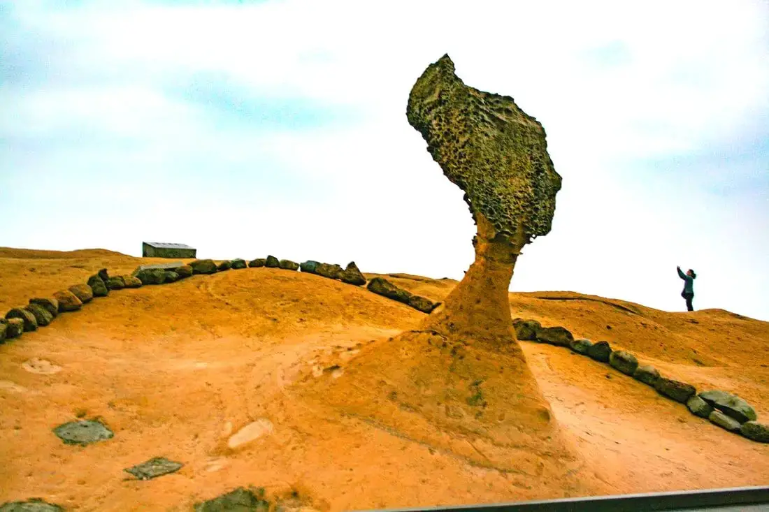
Yehliu is perhaps the most famous geological park in Taiwan, with its most famous landmark being the Queen's Head rock. These rock formations have been forming for thousands of years through erosion of soft sandstone due to wind and water. Hurry and see these formations soon before they are gone forever!
Background: The sandstone that forms the Yehliu formation was created between 10 and 20 million years ago, and was pushed out of the sea along with northern Taiwan thousands of years ago. The Queen's head is formed by two layers of sandstone, one soft fast eroding layer on bottom and a harder layer on top. This kind of sandstone formation can be seen around the world and is known as a hoodoo. The Queen's head was named after Queen Elizabeth I, because it is thought to look like her. The head is eroding .2 to .5 CM per year and is expected to fall at any time! The name Yehliu comes from the Spanish name for the area "Putno Diablos" which was then also used by the Dutch, and transliterated by the Chinese settlers in the area as "Yehliu" in Chinese. Yehliu Ocean world is the largest aquarium in northern Taiwan and has one of the few outdoor sea life amphitheaters in Taiwan. The facility features an indoor aquarium and outdoor show that is geared toward children. Hours: Yehliu Geopark: 8 AM to 5 PM in winter (tickets not sold after 4:30) 8 AM to 6 PM in summer (tickets not sold after 5:30) Yehliu Ocean World: 9 AM to 5 PM Price: Yehliu Geopark: 120 NT per person. You can book discount tickets to Yehliu Geopark on Klook here and KKday here. Yehliu Ocean World: 450 NT per person. You can book discount tickets to Yehliu Ocean World on Klook here and KKday here. You can also book tickets to the Yehliu Ocean World Parent-Child playground on Klook here. Tours: You can book a tour to Yehliu on TripAdvisor here, Klook here, or KKday here. Can I touch the rocks? Don't you dare touch the rocks! Activities along Taiwan's Northern Coast: Don't forget that there are many activities available along Taiwan's Northern Coast such as Wakeboarding, Surfing, Speedboat Surfing, SUP / Paddle Boarding, Diving, Snorkeling Kayaking, Canoeing, Water Biking, River Tracing / Canyoneering, ATVing, Horse Riding, Archery, Tree Climbing, Glamping, Motorcycling, Motorbike Tour, Dragon Boat Racing, Shen'ao Rail Bike, and more on Tripadvisor here, Klook here, or KKday here. Hotels on Taiwan's Northern Coast: We recommend Fullon Hotel which has locations in Tamsui and Fulong near the beach (book on Booking.com here, Tripadvisor here, Agoda here, or Hotels.com here). We have stayed at and recommend Gold Mountain Ranch, which is a horse ranch and glamping destination in Jinshan. You can book a night at Gold Mountain Ranch on Klook here. You can also check out our full blog on the ranch here. We have also stayed at and recommend Hai Xia Your Home which is right in front of Fulong Beach (book on Booking.com here, Tripadvisor here, Agoda here, or Hotels.com here). Looking for a hotel? We recommend booking through Booking.com here, which provides the best quality selection of accommodation in Taiwan. Find out where to stay in our Taiwan hotels guide or search for the best hotel deals in Taiwan here. How to get there: By Bus: There are inter-city buses that leave hourly from Taipei Main Station and Taipei City Hall to Yehliu. You can purchase a discount easy card to use on the MRT and buses from Klook here or KKday here. You can also book an MRT travel pass on Klook here. By Car/Scooter: Take Provincial highway 2 west out of Keelung, and keep going until you reach Wanli. The turnoff to Yehliu comes right after Wanli beach. If you are looking for car rentals, you can also search Qeeq here, Klook here, or KKday here. You can also check out our car rental guide here. Looking for scooter rental in northern Taiwan? You can search on Klook here or KKday here to search for options. You can also check out our scooter rental guide here. By Bicycle: Cycling is the best way to enjoy Taiwan's landscapes if you have the time and energy. Looking for bicycle rentals in Taiwan? You can use Taiwan's many Youbike sharing stations, or search for rentals on KKday here, and search for tours on Klook here. You can also check out our Taiwan cycling guide here. You can also book a cycling tour on TripAdvisor here. For more information, check out our Taiwan transportation guide here. Map: Please see below:
0 Comments
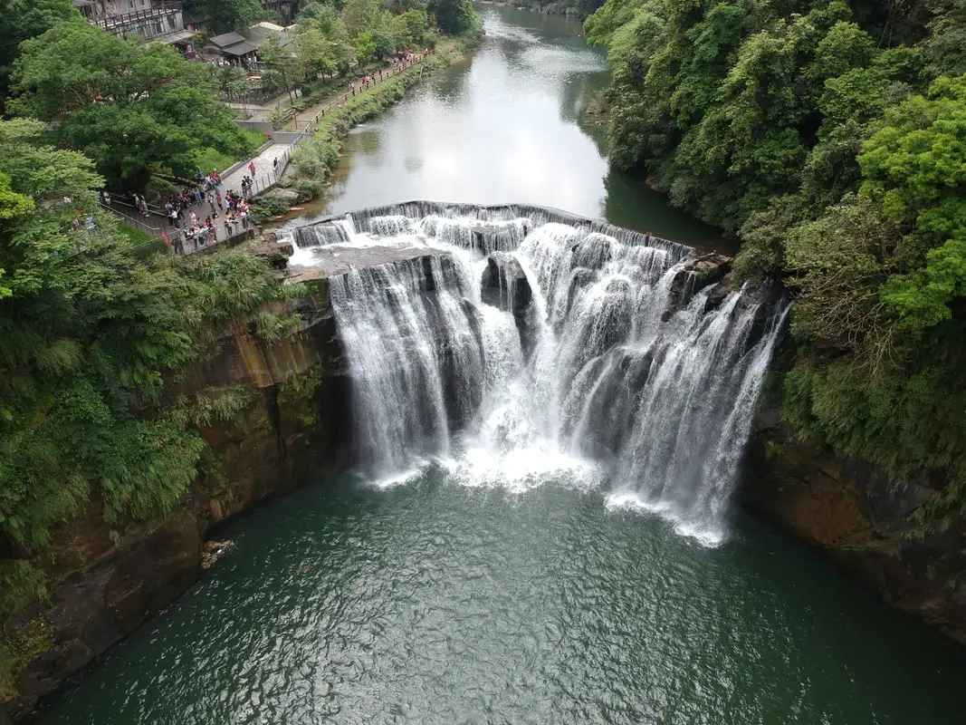
Shifen Waterfall is the widest waterfall in Taiwan, and perhaps the most picturesque in all of Taiwan. It is easily accessible by foot from Shifen Train Station, and includes restaurants, gardens, and suspension bridges along the way. It's spectacular cascading falls are definitely worth a stop for anyone in Taiwan.
Background: Shifen Waterfall is 20 meters high and 40 meters wide (66 x 130 ft.), and is the widest waterfall in Taiwan. It is located near the town of Shifen, which was originally named for the ten families that lived there in the Qing Dynasty, who needed ten portions of goods (Shi = ten Fen = portion). The waterfall lies on the Keelung River which runs through Pingxi and Ruifang, creating a cluster of waterfalls. The rocks here easily erode, making for odd shapes in the riverbed. The waterfall is also known as Taiwan's "Niagra Falls." Before 2010, some government officials illegally charged tickets to see the waterfall. However, since then the waterfall has been made into a park free of any entrance fee. You will also notice that there is a small 1 foot dam on top of the falls. This unnatural feature is according to Taiwan researcher Mike Fagan, "...not a dam, it's a broad-crested weir [that] allows the northern WRA office to calculate flow volume rates." Now you know. Hours: Winter ( October to May): 9 AM -4:30 PM (last people admitted, park open till 5:00 PM) Summer (June to September) 9 AM -5:30 PM (last people admitted, park open till 6:00 PM) Price: Free Tours of Shifen Waterfall: You can book a tour to Shifen on TripAdvisor here, Klook here, or KKday here. There are many tour itineraries that you can enjoy in Shifen that will take you to multiple destinations and arrange transportation. Activities Around Pingxi: Don't forget that there are many activities available around Pingxi such as Rock Climbing, Hiking, kayaking, canoeing, snorkeling, SUP / paddle boarding, water biking, Diving, River Tracing / Canyoneering, ATVing, Horse Riding, Cooking Class, photo shoot, Jingtong Sky Lantern Police Station, Shifen Sky Lantern Experience, Waterfall Zipline, Waterfall Diving, and more on Tripadvisor here, Klook here, or KKday here. Hotels Near Pingxi: We recommend Fullon Hotel which has locations in Tamsui and Fulong near the beach (book on Booking.com here, Tripadvisor here, Agoda here, or Hotels.com here). We have stayed at and recommend Gold Mountain Ranch, which is a horse ranch and glamping destination in Jinshan. You can book a night at Gold Mountain Ranch on Klook here. You can also check out our full blog on the ranch here. We have also stayed at and recommend Hai Xia Your Home which is right in front of Fulong Beach (book on Booking.com here, Tripadvisor here, Agoda here, or Hotels.com here). Looking for a hotel? We recommend booking through Booking.com here, which provides the best quality selection of accommodation in Taiwan. Find out where to stay in our Taiwan hotels guide or search for the best hotel deals in Taiwan here. How to get there: By Train: Take the TRA to Ruifang Station, and then switch to the Pingxi Railway line. Get off at Shifen Station, then walk along the main road south until you reach the Shifen Waterfall trail. It will be hard to miss; there are signs along the way. Book tickets via the normal train (TRA) on Klook here. You can purchase a discount easy card to use on Pingxi Railway Line on Klook here or KKday here. You can also book a travel pass on Klook here. By Car/Scooter: Take provincial highway 2 east toward Pinglin, then get off the main highway once you reach Shifen. The waterfall is to the left of the main bridge across the valley, and parking is plentiful. Scooter parking is free at the entrance. If you are looking for car rentals, you can also search Qeeq here, Klook here, or KKday here. You can also check out our car rental guide here. Looking for scooter rental in Taipei? You can search on Klook here or KKday here to search for options. You can also check out our scooter rental guide here. By Taxi: You can take short rides for about 150 NT, or hire a Taxi for a day for around 150 USD on Klook here. By Bus: You can also book tickets to travel to Shifen via inter-city bus on Klook here. You can also book a Taipei Sightseeing: Hop On, Hop Off Open Top Bus on TripAdvisor here. By Bicycle: Cycling is the best way to enjoy Taiwan's landscapes if you have the time and energy. Looking for bicycle rentals in Taiwan? You can use Taiwan's many Youbike sharing stations, or search for rentals on KKday here, and search for tours on Klook here. You can also check out our Taiwan cycling guide here. You can also book a Sunset Riverside Bike Ride and Historical Tour, 4 Hour Cycling in Taipei, Ultimate 8-Hour Cycling City Tour, or Taipei City Bike Tour with Night Market Experience on TripAdvisor here. For more information, check out our Taiwan transportation guide here. Map: Please see below 
Preface: This blog has taken me countless hours over a few years to compile, so if you want to share the information or photos in this blog, please provide a link and proper citation back to this web page.
The New Taiwan Dollar is the national currency of Taiwan (ROC), and it includes five main bills and five main coins that are currently in circulation. It is one of the sure signs that Taiwan is a free and independent nation. Have you ever wondered what the meaning or significance of the designs on these bills? Well in this blog we will explore these in depth. History: Old Taiwan Dollar: Ever wonder what happened to the old Taiwan Dollar? It was the official currency of Taiwan after 1945, replacing the Japanese Yen that had previously been used at roughly the same price. It was discontinued in 1949 due to hyperinflation that hit China after WWII due to the Chinese Civil War, which also affected Taiwan and the Taiwan Dollar. To help solve hyperinflation, the New Taiwan Dollar was created on June 15, 1949 as the official currency of Taiwan, after the ROC lost the Chinese Civil War and retreated to Taiwan. The currency was valued at 1 New Taiwan Dollar to 40,000 Taiwan Dollars. New Taiwan Dollar Beginnings: The New Taiwan Dollar currency was adopted as the official currency of the Republic of China only in 1961. Before that, Kinmen and Matsu had their own special currency notes, which have been discontinued. In 2001, the New Taiwan Dollar currency stopped being printed at the Bank of Taiwan, and is now printed at Taiwan's Central Bank. The New Taiwan Dollar bills and coins have gone through many changes over the years, but most of them have included either Chiang Kai-shek or Sun Yat-sen on the face of the notes. From 1976 until 2001, most notes were either 10 NT, 100 NT, 500 NT, and 1000 NT. From then until now, there have been five generations or series of notes and coins. This blog will focus on the current fifth series. For a full list of historical notes, click here. Previous Versions: Before the year 2000, prior generations of bank notes were easily copied, as they lacked special marking and printing techniques. Counterfeit bills were often used in night markets and vegetable markets because they would not be scrutinized for their authenticity. In addition, former bills were less durable and could be ruined even if just put through a washing machine cycle. Although current bills can also still be ruined in a washing machine...sigh. Also the fourth generation of bills(which began circulation in 1982) did not include a 20 NT coin or a 200 or 2000 NT bill; and people normally only used 1 NT, 5 NT, 10 NT, 50 NT, 100 NT, 500 NT, and 1000 NT. Because this was not very long ago, part of the reason the 20 NT, 200 NT, and 2000 NT are not widely used is because people are still used to using only 10 NT, 100 NT, 500 NT, and 1000 NT. Current Version: Starting in the year 2000, the central bank began printing the modern fifth generation version of New Taiwan Dollar notes that we use today. The current 100 NT note was first printed in 2000, the 200 NT and 2000 NT notes were first printed in 2001, and the current 500 NT and 1000 NT notes were first printed in 2004. In 2001, the 20 NT coin was introduced, but other coins remained the same. New Taiwan Dollars can be denoted as TWD, NTD, or NT$. Visiting Taiwan soon? You can also find more tours of Taiwan on Klook here or KKday here. You can also check out our full travel guide to Taiwan here. Looking for a hotel? Find out where to stay in our Taiwan hotels guide or search for the best hotels in Taiwan here. Common symbols on the New Taiwan Dollar:
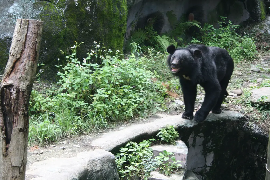
The Taipei Zoo is not only the largest and most varied zoo in Taiwan, it is also one of the best zoos in Asia, and at the same time has an extremely affordable price of only 60 NT per adult. If you have time you should definitely stop by and visit this zoo, if not for anything else but to see Taiwan's ingenious animals like the Formosan Black Bear and Sika Deer which are hard to see in the wild.
Background: The Taipei City Zoo was originally established during the Japanese Era in 1914 near the Yuanshan Hotel. After the ROC took control of Taiwan, elephants, lions, and bears were added to the zoo in 1952. Because there was not enough land to expand the zoo, it was moved to Wenshan District in 1986. Two employees have been killed by animals, one from an elephant and one from a black bear both in the 1970s. There have been no fatalities at the zoo since. The Maokong Gondola was built next to the zoo in 2007, connecting Taipei Zoo with Maokong. The current zoo includes a Taiwan indigenous animal exhibit, children's petting zoo, tropical rain forest exhibit, desert animal exhibit, Australian and African animal exhibits, tropical animal exhibit, petting zoo, insect exhibit, and bird exhibit. There is also indoor Panda exhibit, insect exhibit, amphibian and reptile exhibit, koala exhibit, and penguin exhibit. Hours: 9 AM to 5 PM, tickets are not sold after 4:00 PM. Sometimes in the summer twilight hours are extended to 9:00 PM, but it's not worth going as most all of the animal exhibits are closed after 5:00 PM. Price: 60 NT per person You can book discount tickets to Taipei Zoo on Klook here or KKday here. Tours: You can also book a Taipei Zoo and Maokong Gondola tour on TripAdvisor here. You can also search for tours on Klook here, or KKday here. Hotels in Taipei: We have stayed at and recommend Ximending Amba, which is within walking distance of Ximending shopping district (book on Booking.com here, Hotels.com here, Tripadvisor here, Expedia here, Kayak here, Trip.com here, or Agoda here). We also have stayed at and recommend and Fu Chang Hotel in Ximending, which is within walking distance of Ximending shopping district (book on Booking.com here, Tripadvisor here, or Agoda here). We also have stayed at and recommend the Yuanshan Grand Hotel, once the tallest building in Taiwan and still the most grand (book on Booking.com here, Tripadvisor here, or Agoda here). Looking for a hotel? We recommend booking through Booking.com here, which provides the best quality selection of accommodation in Taiwan. Find out where to stay in our Taiwan hotels guide or search for the best hotel deals in Taiwan here. Just to let you know, if you book using the links above, we get some commission at no cost to you, and you can help support our blog. Some of the Klook links may not work if you are using an Ad blocker. You can click here to receive $5 USD on your first Klook purchase. How to get there: By MRT: Take the brown line MRT to the Taipei Zoo station, then walk north a few hundred meters until you reach the zoo entrance. You can purchase a discount easy card to use on the MRT from Klook here or KKday here. You can also book an MRT travel pass on Klook here. By Car/Scooter: Drive to the Taipei Zoo (via highway 3 or county road 106), and park somewhere on the street or in a parking lot, then walk to the zoo entrance. Looking for scooter rental in Taipei? You can search on Klook here or KKday here to search for options. You can also check out our scooter rental guide here. If you are looking for car rentals, you can also search Qeeq here, Klook here, or KKday here. You can also check out our car rental guide here. By Bicycle: Cycling is the best way to enjoy Taiwan's landscapes if you have the time and energy. Looking for bicycle rentals in Taiwan? You can use Taiwan's many Youbike sharing stations, or search for rentals on KKday here, and search for tours on Klook here. You can also check out our Taiwan cycling guide here. You can also book a Sunset Riverside Bike Ride and Historical Tour, 4 Hour Cycling in Taipei, Ultimate 8-Hour Cycling City Tour, or Taipei City Bike Tour with Night Market Experience on TripAdvisor here. For more information, check out our Taiwan transportation guide here. Map: Please see below: 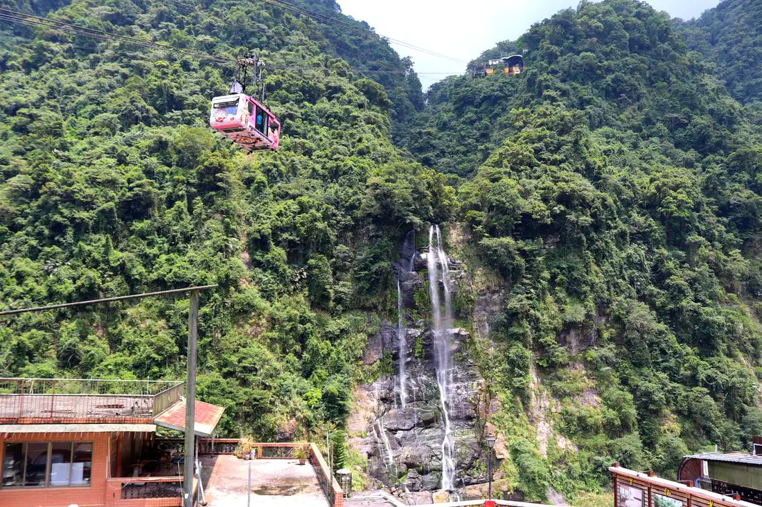
Wulai Waterfall is the highest waterfall in northern Taiwan. Here you can find a street with snacks and restaurants, and a gondola that leads to a second tier of the waterfall and an amusement park. In addition there are hikes, wildlife, and endless mountain scenery to explore.
Background: Wulai was originally an Atayal aborigine village, its name meaning hot and poisonous. There has always been natural hot springs in Wulai, but much of that water has been channeled into hotels and public bathhouses. The free hot springs stood at the bottom of the hill next to the river, and was a collection of used hot spring water from the hotels and paid hot springs above. In its prime, it boasted the largest free outdoor hot springs in Taiwan. Recently the District of Wulai in New Taipei has become a major tourist attraction, partly because of its close proximity to Taipei. It has museums, waterfalls, a gondola, a train, an old street night market, and most of all hot springs. The main delicacies on the old street are Taiwan ingenuous foods such as wild boar meat and rice steamed in bamboo. Wulai waterfall is 80 meters high, making it the highest waterfall in northern Taiwan. It's highest point sits at 230 meters above sea level, and drops to 150 meters above sea level. The waterfall is also about 10 meters wide. Yunceng Amusement Park began construction in 1960 and was completed in 1970. It includes a gondola, hotel, swimming pool, canoe pond, and other activities. Originally it had a roller coaster, pirate ship, and other rides, but these have all been taken down. Hours: Waterfall: 24/7 Cable Car and Yun Hsien Amusement Park Entrance: 9 AM to 4:30 PM You can book tickets to the gondola and to Yun Hsien theme park on Klook here or KKday here. Neidong Waterfall: 8 AM to 5 PM. You can book tickets to Neidong Forest Recreation Area on KKday here or Klook here. Price: Wulai Waterfall: Free Cable Car and Yun Hsien Amusement Park Entrance: 220 NT per person You can book tickets to the gondola and to Yun Hsien theme park on Klook here or KKday here. Neidong Waterfall: 65 NT per person. You can book tickets on KKday here or Klook here. Hot Spring Bath: 300-500 NT. You can look for hot spring bath experiences on Klook here or KKday here. Tours and Activities: You can book a Taiwan Wulai Aboriginal Tribe afternoon Tour on TripAdvisor here. You can also book a tour of Wulai on KKday here. You can also book a ticket on the Wulai Train on Klook here, or a river tracing experience in Wulai on Klook here, or SUP paddleboarding experience in Wulai on KKday here, hot spring baths on Klook here or KKday here, on or tickets to the gondola and to Yun Hsien theme park on Klook here or KKday here. Hotels in Wulai: There are many hot spring hotels in Wulai that have a hot spring tub right in the room. We have stayed at and recommend Wulai SungLyu Hot Spring Resort, which is a hot spring resort with great views just above Wulai Old Street. You can book on Booking.com here, Agoda here, Hotels.com here, TripAdvisor here, Trip.com here, Klook here, Kayak here, or Expedia here. Looking for a hotel? We recommend booking through Booking.com here, which provides the best quality selection of accommodation in Taiwan. Find out where to stay in our Taiwan hotels guide or search for the best hotel deals in Taiwan here. How to get there: By Bus: From central Taipei, take bus 849 to Wulai Waterfall. The trips takes about an hour and a half. You can purchase a discount easy card to use on a bus to Wulai on Klook here or KKday here. You can also book a Taipei travel pass on Klook here. By Car: From Taipei, take provincial highway 9甲 to Wulai. There is a large paid parking garage in front of the old street. You may also be able to find free parking further up the road closer to the waterfall but car parking is very limited. If you are looking for car rentals, you can also search Qeeq here, Klook here, or KKday here. You can also check out our car rental guide here. Looking for scooter rental in Taipei? You can search on Klook here or KKday here to search for options. You can also check out our scooter rental guide here. By Taxi: You can take short rides for about 150 NT, or hire a Taxi for a day for around 150 USD on Klook here. By Bicycle: Cycling is the best way to enjoy Taiwan's landscapes if you have the time and energy. Looking for bicycle rentals in Taiwan? You can use Taiwan's many Youbike sharing stations, or search for rentals on KKday here, and search for tours on Klook here. You can also check out our Taiwan cycling guide here. You can also book a Sunset Riverside Bike Ride and Historical Tour, 4 Hour Cycling in Taipei, Ultimate 8-Hour Cycling City Tour, or Taipei City Bike Tour with Night Market Experience on TripAdvisor here. For more information, check out our Taiwan transportation guide here. Map: Please see below of the places covered in this blog: 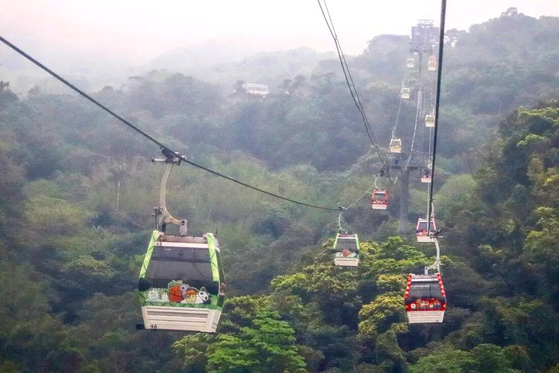
Maokong is only one of a few Gondolas in Taiwan, but it is the most accessible. You can get there via the Taipei MRT. After embarking on the Gondola, you can view grand vistas of Southern Taipei, and then explore the mountainous streets of Maokong, which has tea shops, street food, restaurants, temples, hiking trails, and great views.
Background: The Maokong Gondola was completed in 2007 to improve transportation to Maokong, a tea growing area in Southern Wenshan District of Taipei City. Before, the district could only be reached by small mountain roads. The Gondola was closed from 2008-2010 due to Typhoon damage. Popular activities in the area include tea drinking, hiking, and picture taking. There are four stations on the Gondola: Taipei Zoo Station, Taipei Zoo South Station, Zhinan Temple Station, and Maokong Station. A one way trip takes 12 minutes, and gondola cars which can fit up to eight people (five people in glass cars) come every few seconds. Maokong gets its name from the eroded holes in the rocks around the area; the name literally means “Cat Hole.” The area has been one of the largest areas for tea production in Taipei since the Qing Dynasty. After the completion of the Gondola in 2007, tourists to the area have increased significantly. Hours: 9 AM to 9 PM Price: 120 NT per person one way from Taipei Zoo Station to Maokong Station. 50 NT per trip for Taipei City residents. You can book discount tickets to Maokong Gondola on Klook here or KKday here. Tours: You can also book a Taipei Zoo and Maokong Gondola tour, a Chih Nan Temple & Gondola Experience, or a Maokong Tea & Shenkeng Stinky Tofu Private Day Tour with English-Speaking on TripAdvisor here. You can also search for tours on Klook here, or KKday here. Hotels in Taipei: We have stayed at and recommend Ximending Amba, which is within walking distance of Ximending shopping district (book on Booking.com here, Hotels.com here, Tripadvisor here, Expedia here, Kayak here, Trip.com here, or Agoda here). We also have stayed at and recommend and Fu Chang Hotel in Ximending, which is within walking distance of Ximending shopping district (book on Booking.com here, Tripadvisor here, or Agoda here). We also have stayed at and recommend the Yuanshan Grand Hotel, once the tallest building in Taiwan and still the most grand (book on Booking.com here, Tripadvisor here, or Agoda here). Looking for a hotel? We recommend booking through Booking.com here, which provides the best quality selection of accommodation in Taiwan. Find out where to stay in our Taiwan hotels guide or search for the best hotel deals in Taiwan here. Just to let you know, if you book using the links above, we get some commission at no cost to you, and you can help support our blog. Some of the Klook links may not work if you are using an Ad blocker. You can click here to receive $5 USD on your first Klook purchase. How to get there: By MRT: Take the brown line MRT to the Taipei Zoo station, then walk south a few hundred meters until you reach the gondola station on the east side of the main road. You can purchase a discount easy card to use on the MRT from Klook here or KKday here. You can also book an MRT travel pass on Klook here. By Car/Scooter: Drive to the Taipei Zoo, and park somewhere on the street or in a parking lot, the walk to the Gondola Station. You can search on Klook here or KKday here to search for options. You can also check out our scooter rental guide here. If you are looking for car rentals, you can also search Qeeq here, Klook here, or KKday here. You can also check out our car rental guide here. (You can also take the Gondola from the southern station inside the Zoo or from Zhinan Temple) By Bicycle: Cycling is the best way to enjoy Taiwan's landscapes if you have the time and energy. Looking for bicycle rentals in Taiwan? You can use Taiwan's many Youbike sharing stations, or search for rentals on KKday here, and search for tours on Klook here. You can also check out our Taiwan cycling guide here. You can also book a Sunset Riverside Bike Ride and Historical Tour, 4 Hour Cycling in Taipei, Ultimate 8-Hour Cycling City Tour, or Taipei City Bike Tour with Night Market Experience on TripAdvisor here. For more information, check out our Taiwan transportation guide here. Map: Please see below: 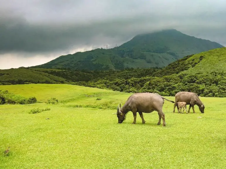
Qingtiangang in Yangmingshan National Park is a large grassland that lies on top of an old lava terrace. It is famous for the water buffalo that congregate here to graze and is one of the most popular areas in the park. Besides enjoying views of wild water buffalo, there are also many hiking trails and historic trails nearby. Overall it is a family-friendly destination and one of the most popular attractions in Taipei City.
Background: Qingtiangang, literally meaning "Hill Holding up Heaven" gets its name from the KMT Qingtian garrison that once guarded the hills and grasslands here. Officially it lies in Shilin District of Taipei, but parts of the grassland also lie in Jinshan District of New Taipei. The grassland lies 770 meters above sea level. The area known as Yangmingshan now was formed by volcanoes about 700,000 years ago, forming many mountains about 1000 meters or less in northwestern Taiwan. The park still features active volcanoes, vents, and hot springs. The original name of the area was Caoshan (grass mountain 草山). During the Qing Dynasty, the area was used to harvest sulfur, and many of the hills were burned to help catch sulfur thieves, Qingtiangang likely being one of these areas. Sulfur mining at Dayoukeng Crater in Yangmingshan National Park started in the Qing Dynasty by a British mining company who first obtained the rights to mine here in 1897. Currently you can find lots of old mining equipment that were abandoned here. The Yulu Old Trail was built near Dayoukeng to transport mining materials, and extended over to Qingtiangang. Mining sulfur ended with the formation of Yangmingshan National Park. In 1927 during the Japanese era, Yangmingshan was made as the first national park in Taiwan, then known as Datunshan National Park Association. The area around Qingtiangang to Lengshuikeng was made into a ranch for water buffalo, and grass from Japan was planted here for them to graze. In 1950 after the ROC took Taiwan, Chiang Kai-shek renamed the park after the philosopher Wang Yangming, and called the area Yangmingshan. The KMT kept the ranch at Qingtiangang and continued to maintain it. They also built bunkers here and kept a garrison of troops. In 1985, after resolving many land disputes, Yangmingshan National Park was officially designated as a national park in the ROC era. In2018, a mother died after being pushed over by a water buffalo at Qingtiangang. In 2020, the family was awarded NT$3.96 million from the park and wooden fences were built around the grasslands shortly after. The water buffalo at Qingtiangang are actually closely watched and cared for. Although they roam free around Yangmingshan, they are watched over by the Agricultural Associations of Jinshan, Shilin, Yangmingshan, and Beitou, and well as the national park management. In the winter of 2020 which was unusually wet, tens of cows began to die of malnutrition, therefore the park took steps to supplement the diet of the remaining cattle. Many cows were brought to lower eve lavations for rehabilitation before being released back to Yangmingshan. Due to its easy accessibility and nearby attractions such as Lengshuikeng and Qixingshan, it is a popular stop in Yangmingshan and has a parking lots and a visitor's center. In addition, it is one of the most popular tourist destinations in Taipei City. Hours: The visitor's center is open from 9 AM to 4:30 PM. Price: Free (car parking 30-50 NT, scooter parking 20 NT) You can book tours to Yangmingshan on TripAdvisor here, Klook here, or KKday here or here. Tours: You can check out tours to Yangmingshan such as a One-day Yangmingshan NP Beitou Hot Spring Park and Tamsui Tour Package, Beitou and Yangmingshan Day Tour from Taipei, One Day Hike around Yangmingshan, or Private Yangmingshan Volcano Tour and more on TripAdvisor here, Klook here, or KKday here. Hotels in Taipei: High end: We have stayed at and recommend the Yuanshan Grand Hotel, once the tallest building in Taiwan and still the most grand (book on Booking.com here, Tripadvisor here, or Agoda here). We also recommend Fullon Hotel which has locations in Tamsui and Fulong near the beach (book on Booking.com here, Tripadvisor here, Agoda here, or Hotels.com here). Budget Hotels: We have stayed at and also recommend Fu Chang Hotel in Ximending, which is within walking distance of Ximending shopping district (book on Booking.com here, Tripadvisor here, or Agoda here). We have also stayed at and recommend Hai Xia Your Home which is right in front of Fulong Beach (book on Booking.com here, Tripadvisor here, Agoda here, or Hotels.com here). Looking for a hotel? We recommend booking through Booking.com here, which provides the best quality selection of accommodation in Taiwan. Find out where to stay in our Taiwan hotels guide or search for the best hotel deals in Taiwan here. How to get there: By Car/Scooter: From Taipei, take provincial highway 2A north to the Zhuzihu Lookout. Keep right until you reach the turnoff the the Qingtiangang parking lot. Car parking is limited on weekends and the number of cars allowed up the mountain is also limited. There is also paid scooter parking. On weekends this place can be the most popular place in the park, and cars can be backed up for up to an hour or more, so consider taking a scooter or bus. Looking for scooter rental in Taipei? Check out Qeeq here, Klook here, or KKday here to search for options. You can also check out our scooter rental guide here. If you are looking for car rentals, you can also search Qeeq here, Klook here, or KKday here. You can also check out our car rental guide here. By Bus: From Beitou MRT Station, Take Little Bus 9 (小9) to Qingtiangang Station (擎天崗). You can book tickets to travel to Taipei via inter-city bus on Klook here. By Bicycle: Cycling is the best way to enjoy Taiwan's landscapes if you have the time and energy. Looking for bicycle rentals in Taiwan? You can use Taiwan's many Youbike sharing stations, or search for rentals on KKday here, and search for tours on Klook here. You can also check out our Taiwan cycling guide here. ​You can also book a Sunset Riverside Bike Ride and Historical Tour, 4 Hour Cycling in Taipei, Ultimate 8-Hour Cycling City Tour, or Taipei City Bike Tour with Night Market Experience on TripAdvisor here. Map: Please see below: 
Bianzhou Park is a large grassy park in Taoyuan District of Taoyuan City. Here you can enjoy three circular "pump track" bike paths, slides, walking paths, and more. You can also check out the nearby Hexian Temple.
Historical Background: Bianzhou Park was completed in 2014, with mostly just grassy spaces. The park was renovated in 2021 to include three pump tracks. Pump tracks are hilly obstacles made especially for bicycles. They have wavy, hilly, and quarter-pipe-like structures. The park is popular on weekends and you will often see small children practice riding balance bikes here. Hexian Temple was constructed in 1987, and the main deity there is the Lotus Leaf Immortal Master, who is said to be the God of Construction, his God statue was thought to have been brought over from China over 100 years ago. Before the temple was built, the God was carried from place to place and worshipped by construction workers in Taiwan. There is also a funeral and cremation area near the temple. Price: Free Hours: 24/7 Where to stay: Looking for a hotel in Taoyuan? We recommend the Novotel Taipei Taoyuan International Airport which has great service and is conveniently located right next to Taoyuan Airport, the MRT, and HSR station (you can book on Agoda here or Booking.com here). We also recommend the Fullon Hotel Taoyuan which also has great service and is located in downtown Taoyuan City (you can book on Agoda here or Booking.com here). Looking for a hotel? We recommend booking through Booking.com here, which provides the best quality selection of accommodation in Taiwan. Find out where to stay in our Taiwan hotels guide or search for the best hotel deals in Taiwan here. Activities in Taoyuan: Ice Skating, Rock Climbing, Mountain Climbing, Cycling, High Ropes, Ziplining, Archery, Vietnamese BBQ, Batting Cages, Glamping, Van Camping, Photo Shoot, Turkish Mosaic DIY, Thai Massage, Painting, Baking, Go Karting, Imax Theater, Japanese Style Buffet, Tourist Factory Experience, peach and fruit picking, Ring-making DIY, handmade popsicle DIY, and more on on Tripadvisor here, Klook here, or KKday here. How to get there: By Car: From Taoyuan, take Provincial Highway 4 north and turn right on Jianxing Road. The park is at the end of the road. There is limited free parking on the side of the road and paid parking nearby. If you are looking for car rentals, you can also search Qeeq here, Klook here, or KKday here. By Scooter: From Taoyuan, take Provincial Highway 4 north and turn right on Jianxing Road. The park is at the end of the road. There is free parking on the side of the road. Looking for scooter rental in Taoyuan? Search Klook here or KKday here to look for options. By TRC/Bus: You can take the local train to Taoyuan TRC Station, then take bus 168 to the Park City station. The bus ride takes about 30 minutes. You can book tickets to travel to Taoyuan via inter-city bus on Klook here. Book tickets via the normal train (TRA) on Klook here. By Bicycle: Cycling is the best way to enjoy Taiwan's landscapes if you have the time and energy. Looking for bicycle rentals in Taiwan? You can use Taiwan's many Youbike sharing stations, or search for rentals on KKday here, and search for tours on Klook here. You can also check out our Taiwan cycling guide here. You can also book a cycling tour on TripAdvisor here. For more information, check out our Taiwan transportation guide here. Map: See below: 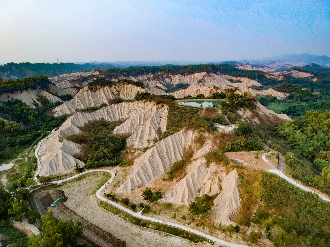
Out in the foothills of former Kaohsiung County are tropical badlands, hills of easily eroding material that makes the landscape look so unique that you must think that it's on the moon. In the summer of 2014 the Foreigners in Taiwan team took a journey to this park in Tianliao which showcases these hills with trails and beautiful scenic views, and 4 years later here is the blog. It's definitely a strange landscape especially for Taiwan, and is worth a visit especially if you want to get some unique photos. You can also see some nearby mud hot springs.
Geological History: Moon World is part of a stretch of badlands that cover a large swath of southern Taiwan near the central mountain range. Typical badlands are found in dryer climates, are composed of sedimentary rocks, typically have very little vegetation, and have deep valleys or ravines. The badlands in Taiwan are unique in that they are in a tropical rain forest. How is this possible? The rocks at Moon World are composed of mudstone, sandstone, shale, and chalk. Because of high alkaline levels due to chalk in the soil, trees and grass cannot grow, and basically the only plant that can grow in the soil is spiny bamboo. The lack of vegetation as well as high rainfall gives way to quick eroding hills, or badlands. The Caoshan River and the Ganglin Rovers also helped to carve out the landscape and bare hills. Because of the white greyish color, the hills seem to glow when in moonlight,hence the name "Moon World." However to the casual observer, the landscape looks like the surface of the moon as well. Hours: All Day. However buses and restaurants will not run all day (there is no 7-11, only round-table chicken quick fry restaurants 土鷄). Price: Free! Accommodation We have stayed at and recommend Chao She Hotel (you can book on Agoda here, Booking.com here, Hotels.com here, or Expedia here) IHI Sanduo Travel Hotel (you can book on Agoda here, Booking.com here, Hotels.com here, or Expedia here), and Mingli Hotel (you can book on Agoda here, Klook here, or Hotels.com here) which are three inexpensive and high quality choices in downtown Kaohsiung. I also have stayed at and recommend Kaohsiung Meinong Rabbit Paul Homestay B&B (you can book on Agoda here, Booking.com here, or Trip.com here), a quiet B&B in rural Meinong, and Chengching Lakeside Resort (you can book on Agoda here, Booking.com or Trip.com here)and the Grand Hotel Kaohsiung (you can book on Agoda here, Booking.com here, Hotels.com here, or Expedia here) which both offer breakfast buffet and free entrance into Chenqing Lake Park. I have also stayed at the 85 sky tower which offers great views of the city; you can search for rooms in the 85 sky tower on Agoda here, Booking.com here, Hotels.com here, Expedia here, or Trip.com here). Find out more about where to stay in our Taiwan hotels guide or search for the best hotel deals in Taiwan here. We recommend booking through Agoda here, which provides the best quality selection of accommodation on the islands. You can also book Wifi and SIM cards for Taiwan on Gigago here. Need travel insurance? Compare prices on Insubuy here. Tours: You can find more tours and activities in Kaohsiung such as Pier 2, Meinong Hakka Museum, Hamasen Railway Museum, Suzuka Circuit Park, i-Ride Kaohsiung Visual 5D Flying Theater, National Science and Technology Museum , Senya Village Restaruant, Austin Land, Ski School Indoor Ski Slope, and many more on Klook here or KKday here. Just to let you know, if you book using the links above, we get some commission at no cost to you, and you can help support our blog. You can click here to receive $5 USD on your first Klook purchase. How to Get There: By Bus: You can either take the Kaohsiung City bus Red 70B from the Gangshan MRT station, or Kbus 8042 from Tainan HSR station. You can book tickets to travel to Kaohsiung via inter-city bus on Klook here. You can book tickets to Kaohsiung via high speed rail (HSR) on Klook here or KKDay here. Book tickets via the normal train (TRA) on Klook here. You can also book a Kaohsiung Travel pass here. By Car/Scooter: Take the Tianliao Exit on National Highway 3 and take provincial highway 28 to Tianliao. Looking for scooter rental in Kaohsiung? You can check out Klook here or KKday here to search for options. You can check also out our scooter rental guide here. If you are looking for car rentals, you can search Qeeq here, KKday here, or Klook here. You can also check out our car rental guide here. Please refer to the map below: 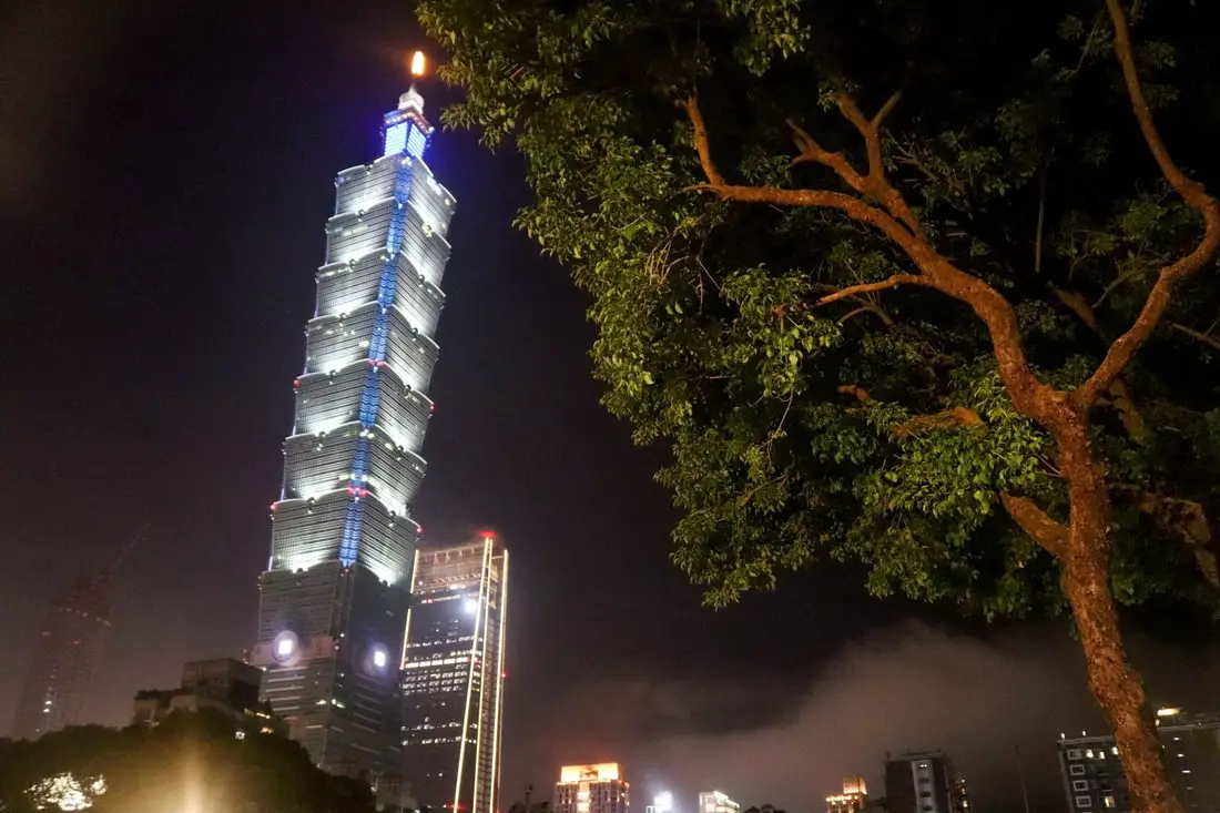
The Taipei 101 (aka Taipei World Financial Center) is the tallest building in Taiwan, standing at a height of 509 meters. It was the tallest building in the world from 2004 to 2010 and is now the 11th tallest building in the world as of 2023. It stands as an icon and symbol of Taiwan's economic prosperity and may be the most recognizable building in Taiwan. It also features observatories on the 89th, 91st, and 101st floors with some of the best views of Taipei.
Taipei 101 Q + A: What is the Taipei 101? It was the tallest building in the world from 2004-2010, with 101 floors above ground (hence the name 101) and 5 floors below ground. It was designed by C.Y. Lee & Partners, and also had the fastest elevator in the world until 2016. It is an icon of Taiwan technological advancement. How was Taipei 101 built? The Taipei 101 was built in a period of 5 years from 1999-2004. The Taipei 101 is reinforced by concrete piles driven 80 meters below the ground and 30 meters into bedrock. In addition, it is made of high-strength reinforced steel and flexible materials. It was designed by C.Y. Lee & Partners and also had the fastest elevator in the world until 2016. How much did the Taipei 101 cost? NT$ 58 billion (US$1.934 billion) How is the Taipei 101 earthquake proof? How does the Taipei 101 withstand earthquakes? The Taipei 101 is reinforced by concrete piles driven 80 meters below the ground and 30 meters into bedrock. In addition, it is made of high-strength reinforced steel and flexible materials. How does the Taipei 101 damper work? The damper works by offsetting strong wind gusts, absorbing the forces, and turning them into kinetic energy, moving the damper. How much does the Taipei 101 sway? The most that the Taipei 101 damper has ever swayed was during Typhoon Soudelor, swaying 100 centimeters (39 in). See below for a video! Hours: The Taipei 101 Observatory is open every day from 9 AM to 10 PM. When to go: In my opinion, the best time to go is on a sunny morning just after it has rained so that there is no haze in the air. Price: 88, 89, and 91, observatory floors: 600 NT (20 USD) per person. You can book a discount ticket on TripAdvisor here, Klook here, or KKday here. 101st-floor "Skyline 460" observation deck (in addition to 88, 89, and 91 floors): 3000 NT (100 USD) per person. You can book a discount ticket on Klook here. You can book tours to the Taipei 101 such as 101 Top Floor Tour and Dinner at Din Tai Fung, Taipei 101 Observation Deck activity, or Din Tai Fung and Hot Spring Experience on TripAdvisor here or Klook here. Hotels in Taipei: High end: We have stayed at and recommend the Yuanshan Grand Hotel, once the tallest building in Taiwan and still the most grand (book on Booking.com here, Tripadvisor here, or Agoda here). We have also stayed at and recommend the Grand Hyatt (book on Booking.com here, Tripadvisor here, Agoda here, or Hotels.com here), Marriot (book on Booking.com here, Tripadvisor here, Agoda here, or Hotels.com here), Sheraton (book on Booking.com here, Tripadvisor here, Agoda here, or Hotels.com here), Shangri-la (book on Booking.com here, Tripadvisor here, Agoda here, or Hotels.com here), and Regent (book on Booking.com here, Tripadvisor here, Agoda here, or Hotels.com here), which are all very high quality hotels in the middle of Taipei City. We also recommend Fullon Hotel which has locations in Tamsui and Fulong near the beach (book on Booking.com here, Tripadvisor here, Agoda here, or Hotels.com here). Budget Hotels: We have also stayed at and recommend Fu Chang Hotel in Ximending, which is within walking distance of Ximending shopping district (book on Booking.com here, Tripadvisor here, or Agoda here). We have also stayed at and recommend Hai Xia Your Home which is right in front of Fulong Beach (book on Booking.com here, Tripadvisor here, Agoda here, or Hotels.com here). Looking for a hotel? We recommend booking through Booking.com here, which provides the best quality selection of accommodation in Taiwan. Find out where to stay in our Taiwan hotels guide or search for the best hotel deals in Taiwan here. Just to let you know, if you book using the links above, we get some commission at no cost to you, and you can help support our blog. Some of the Klook links may not work if you are using an Ad blocker. You can click here to receive $5 USD on your first Klook purchase. How to get there: Take the MRT red line to the Taipei 101/World Trade Center station. There is limited paid parking nearby. By MRT: (Mass Rapid Transit, Metro train, subway) – Easily gets you around Taipei and Kaohsiung. You can also book an MRT travel pass on Klook here. By Taxi: You can take short rides for about 150 NT, or hire a Taxi for a day for around 150 USD. By Car: If you are looking for car rentals, you can also search Qeeq here, Klook here, or KKday here. You can also check out our car rental guide here. By Scooter: Looking for scooter rental in Taipei? You can search on Klook here or KKday here to search for options. You can also check out our scooter rental guide here. By Bicycle: Cycling is the best way to enjoy Taiwan's landscapes if you have the time and energy. Looking for bicycle rentals in Taiwan? You can use Taiwan's many Youbike sharing stations, or search for rentals on KKday here, and search for tours on Klook here. You can also check out our Taiwan cycling guide here. You can also book a Sunset Riverside Bike Ride and Historical Tour, 4 Hour Cycling in Taipei, Ultimate 8-Hour Cycling City Tour, or Taipei City Bike Tour with Night Market Experience on TripAdvisor here. For more information, check out our Taiwan transportation guide here. Map: 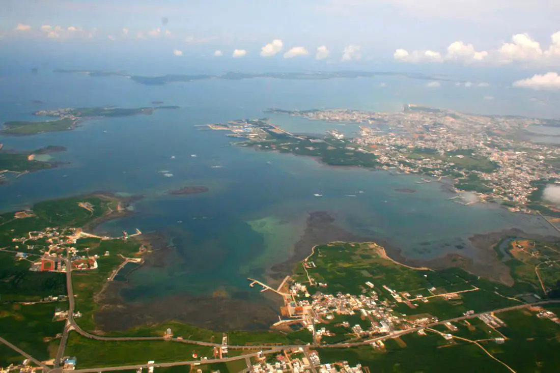
If Taiwan is the best kept secret in Asia, then Penghu is the best kept secret of the best kept secret in Asia. It has just everything you could possibly want from a tropical island vacation getaway. Less than an hour plane ride from Taipei with multiple flights daily, it's also easy to get to. We are sure that a trip to Penghu is one that you will not regret, and there will be more things to do than you could ever have time for.
History of Penghu: The Penghu Islands were historically an important strategic position for trade and military defense in the area. The Dutch, French, and Japanese all led campaigns against these islands. The Dutch first invaded Penghu in 1622, but soon after retreated to Anping after a treaty was made with the Ming Dynasty. Konxinga later took control of Penghu and Taiwan after defeating the Dutch in 1661, Later, Kongxinga's kingdom fell to the Qing Dynasty. In 1885 during the Sino-French war for control of Vietnam, the French sent a fleet to Taiwan but failed to take the island. Later they attacked the Penghu Islands and occupied them for a short time, before retreating to Vietnam due to the Treaty of Tianjin. After Japan took control of Korea in 1894, they also attacked and occupied Penghu in 1895, after which the Qing Dynasty ceded the islands to them. After World War II, the islands were given to the ROC government, which retreated to Taiwan after the Chinese Civil War and still controls the islands today under a free democratic government. How to get there: By Plane: There are daily flights from Taipei Songshan, Taichung, and Kaohsiung airports to Makung. the flight takes roughly under and hour. Rates can range from around 2200-6000 NT for a round trip. There are also flights to and from Chiayi, Tainan, Kinmen, and Chimei, with charted flights to Hong Kong starting September 2018. There are flights to and from Taipei Songshan Airport three times a day via Uni Air. You can book flights on KKday here, Trip.com here, CheapO Air here, or Kiwi here. By Boat: There are daily ferries from Chiayi and Kaohsiung. A one way trip takes about 4 hours from both locations. A one way ferry from Kaohsiung costs about 900 NT for just a reclining seat, and a one way ferry from Chiayi costs about 1000 NT. You can book ferry boat tickets from Chiayi on Klook here, or ferry boat tickets from Tainan on KKday here. Getting Around on the Islands: By Ferry Boat: The only way to get to smaller islands without airports is by ferry. You can check KKday here or Klook here for ferry tickets or buy them at the harbor. By Scooter: We recommend taking a scooter as the most efficient and convenient type of transport on the islands. However, most places require a local scooter license. You can rent a scooter for Penghu on Klook here or on KKday here. You can also check out our scooter rental guide here. By Car / taxi: A car is also sensible in Penghu because the main island is pretty spread out. You can rent a car for Penghu on Klook here or on KKday here. You can also check out our car rental guide here. By Bus: a bus is possible on the main island, but it will be slower and more unpredictable. By Bicycle: Cycling is the best way to enjoy Taiwan's landscapes if you have the time and energy. Looking for bicycle rentals in Taiwan? You can search on KKday here and search for tours on Klook here. You can also check out our Taiwan cycling guide here. Tours: There are many tours and activities available on the islands such as snorkeling, diving, wind surfing, sailing, canoeing, starlight Marine Ranch, wakeboarding, seafood Barbeque, massage, yachting, glamping, trampoline Water Sports, South Penghu Marine National Park, SUP / Paddle Boarding, kayaking, night fishing, Sheraton Four Points Eatery, Dragon Palace Intertidal Zone, Jibei Sand Tail, and many more options. For more information, look at other tour/ferry sites or book a personalized tour with Klook here or KKday here. Accommodation: We have stayed at and recommend Han's Hostel which had great service and is right next to Shanshui Beach, the best beach in Penghu (you can book on Agoda here, Booking.com here, or Trip.com here), and Cherry Inn Penghu, a newly renovated homestay in downtown Magong with great service and great prices (you can book on Agoda here, Booking.com here, Klook here, Trip.com here, Hotels.com here, or Expedia here). Looking for a hotel? We recommend booking through Agoda here, which provides the best quality selection of accommodation on the islands. You can also find out more about where to stay in our Taiwan hotels guide here. You can also book Wifi and SIM cards for Taiwan on Gigago here. Need travel insurance? Compare prices on Insubuy here. Just to let you know, if you book using the links above, we get some commission at no cost to you, and you can help support our blog. You can click here to receive $5 USD on your first Klook purchase. When to go there: Spring to Autumn. Winters are rather miserable. Map: Please see below: 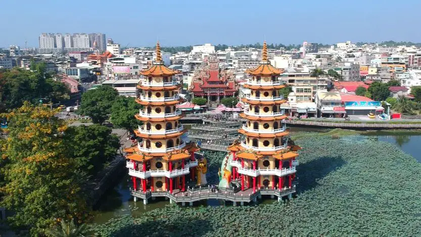
The Lotus Pond in Zuoying District of Kaohsiung is one of the most beautiful scenic areas in Taiwan. Much of the lake is full of traditional Chinese temples, gardens, and architecture. Because of its size, it cannot be properly appreciated by only going there for one afternoon; there are simply too many things to see and do there. In this blog, we will provide you a detailed virtual tour of the entire lake.
Historical Background: Lotus Pond was originally a small natural pond next to what is now the Zuoying Confucious Temple. Starting from 1686 after the Qing Dynasty captured Taiwan from the Kingdom of Tungming, the pond was gradually expanded for water storage and irrigation purposes. Also, lotus plants were cultivated on the pond, giving it its name. It was known as one of the eight beautiful scenes of Fengshan Old City. It also became a hotbed for temple building, and now over 20 temples stand by the lake. In 1951 the Qiming Temple, Spring and Autumn Pavilions, and Guanwu God Temple were completed. In 1976 the Dragon and Tiger pagodas were completed. In 1978 Wuli Pavilion was completed. Every year over a million visitors come to the park, although these numbers have gone down in recent years due to aging infrastructure and lack of new attractions. It is a haven for retired Taiwanese people to come and relax. Due to its close proximity to the Zuoying Jiucheng TRA station and Zuoying HSR station, it is also a popular attraction for tourists in Kaohsiung. Price: Free You can book water sport activities at the Lotus Pond on Klook here or KKday here. Hours: 8 AM - 6 PM (Dragon and Tiger Pagodas) Accommodation We have stayed at and recommend Chao She Hotel (you can book on Agoda here, Booking.com here, Hotels.com here, or Expedia here) IHI Sanduo Travel Hotel (you can book on Agoda here, Booking.com here, Hotels.com here, or Expedia here), and Mingli Hotel (you can book on Agoda here, Klook here, or Hotels.com here) which are three inexpensive and high quality choices in downtown Kaohsiung. I also have stayed at and recommend Kaohsiung Meinong Rabbit Paul Homestay B&B (you can book on Agoda here, Booking.com here, or Trip.com here), a quiet B&B in rural Meinong, and Chengching Lakeside Resort (you can book on Agoda here, Booking.com or Trip.com here)and the Grand Hotel Kaohsiung (you can book on Agoda here, Booking.com here, Hotels.com here, or Expedia here) which both offer breakfast buffet and free entrance into Chenqing Lake Park. I have also stayed at the 85 sky tower which offers great views of the city; you can search for rooms in the 85 sky tower on Agoda here, Booking.com here, Hotels.com here, Expedia here, or Trip.com here). Find out more about where to stay in our Taiwan hotels guide or search for the best hotel deals in Taiwan here. We recommend booking through Agoda here, which provides the best quality selection of accommodation on the islands. You can also book Wifi and SIM cards for Taiwan on Gigago here. Need travel insurance? Compare prices on Insubuy here. Tours: You can find more tours and activities in Kaohsiung such as Pier 2, Meinong Hakka Museum, Hamasen Railway Museum, Suzuka Circuit Park, i-Ride Kaohsiung Visual 5D Flying Theater, National Science and Technology Museum , Senya Village Restaruant, Austin Land, Ski School Indoor Ski Slope, and many more on Klook here or KKday here. Just to let you know, if you book using the links above, we get some commission at no cost to you, and you can help support our blog. You can click here to receive $5 USD on your first Klook purchase. How to Get There: By Car/Scooter: From central Kaohsiung, go north on provincial highway 17 and then turn north on Xinzhuang 1st Road. The pond is on your left and is hard to miss. There is free and paid parking all around the lake. Looking for scooter rental in Kaohsiung? You can check out Klook here or KKday here to search for options. You can check also out our scooter rental guide here. If you are looking for car rentals, you can search Qeeq here, KKday here, or Klook here. You can also check out our car rental guide here. By Train: From the north you can walk to the pond from Zuoying HSR station, or from the south you can walk there from Zuoying Jiucheng TRA Station. You can book tickets to travel to Kaohsiung via inter-city bus on Klook here. You can book tickets to Kaohsiung via high speed rail (HSR) on Klook here or KKDay here. Book tickets via the normal train (TRA) on Klook here. You can also book a Kaohsiung Travel pass here. By Bicycle: Cycling is the best way to enjoy Taiwan's landscapes if you have the time and energy. Looking for bicycle rentals in Taiwan? You can search on KKday here and search for tours on Klook here. You can also check out our Taiwan cycling guide here. Map: 
Qijin Island (aka Cijin Island or Chijin Island) has one of the most accessible sandy beaches to any urban area in Taiwan. Besides the nearly 10 Km stretch of sandy shores, the island also has an old street with tasty snacks, a seafood market, a lighthouse, an ancient fort, a star tunnel, a shell museum, and much more. It is one of the most popular destinations in Kaohsiung and definitely worth a trip.
Background: Qijin Island was first settled by a Chinese fisherman named Hsu Ah-hua (徐阿華) in the 1600's, discovered after he took shelter there during a typhoon. He brought many families with him from Fujian to settle there. They created the first Mazu temple there, Chi Jin Mazu Temple in 1673. The lighthouse dates from 1883 and was built in the English style. The fort on the hill to the north of the Island was completed in 1875 during the Qing dynasty. After WWII, Qijin was made a district of Kaohsiung City. In 1979, Taiping Island and Dongsha Island were added under the district's administration. Qijin Island used to be a sandbar peninsula, but was separated from mainland Taiwan at its southern tip to make a second entrance into Kaohsiung Harbor in 1967. There were plans for a cross harbor gondola but they were scrapped due to the height needed to cover the harbor. Price: Passenger ferry crossing: 40 NT Bicycle ferry crossing: 50 NT Motorcycle ferry crossing: 80 NT Showers: Free! Hours: 24/7 Tours: You can find more tours and activities in Kaohsiung such as Pier 2, Meinong Hakka Museum, Hamasen Railway Museum, Suzuka Circuit Park, i-Ride Kaohsiung Visual 5D Flying Theater, National Science and Technology Museum , Senya Village Restaruant, Austin Land, Ski School Indoor Ski Slope, and many more on Klook here or KKday here. Just to let you know, if you book using the links above, we get some commission at no cost to you, and you can help support our blog. You can click here to receive $5 USD on your first Klook purchase. Accommodation We have stayed at and recommend Chao She Hotel (you can book on Agoda here, Booking.com here, Hotels.com here, or Expedia here) IHI Sanduo Travel Hotel (you can book on Agoda here, Booking.com here, Hotels.com here, or Expedia here), and Mingli Hotel (you can book on Agoda here, Klook here, or Hotels.com here) which are three inexpensive and high quality choices in downtown Kaohsiung. I also have stayed at and recommend Kaohsiung Meinong Rabbit Paul Homestay B&B (you can book on Agoda here, Booking.com here, or Trip.com here), a quiet B&B in rural Meinong, and Chengching Lakeside Resort (you can book on Agoda here, Booking.com or Trip.com here)and the Grand Hotel Kaohsiung (you can book on Agoda here, Booking.com here, Hotels.com here, or Expedia here) which both offer breakfast buffet and free entrance into Chenqing Lake Park. I have also stayed at the 85 sky tower which offers great views of the city; you can search for rooms in the 85 sky tower on Agoda here, Booking.com here, Hotels.com here, Expedia here, or Trip.com here). Find out more about where to stay in our Taiwan hotels guide or search for the best hotel deals in Taiwan here. We recommend booking through Agoda here, which provides the best quality selection of accommodation on the islands. You can also book Wifi and SIM cards for Taiwan on Gigago here. Need travel insurance? Compare prices on Insubuy here. How to get there: By Passenger Ferry: Ferry's leave from Gushan near Xiziwan MRT station about every 10 minutes 24/7 (every half hour at after midnight). Or there is also another passenger ferry in Qianzhen that connects with Zhong Zhou Ferry Terminal. The gates are only open in the early morning and in the afternoon as noted above. You can book tickets to travel to Kaohsiung via inter-city bus on Klook here. You can book tickets to Kaohsiung via high speed rail (HSR) on Klook here or KKDay here. Book tickets via the normal train (TRA) on Klook here. You can also book a Kaohsiung Travel pass here. By Car/Scooter: Take the underwater tunnel on the south side of the island. Scooters can cross, but not bicycles. Looking for scooter rental in Kaohsiung? You can check out Klook here or KKday here to search for options. You can check also out our scooter rental guide here. If you are looking for car rentals, you can search Qeeq here, KKday here, or Klook here. You can also check out our car rental guide here. Map: Please see below for the places we will cover in this blog: 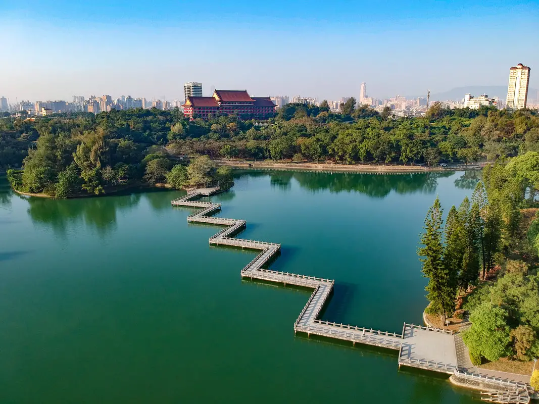
Cheng Ching Lake (aka Cheng Cing Lake or Ching Qing Lake) in Kaohsiung is one of the most beautiful parks in Taiwan. Much of the lake is full of traditional Chinese gardens and architecture. Because of its size, it cannot be properly appreciated by only going there for one afternoon; there are simply too many things to see and do there. In this blog, we will provide you a detailed virtual tour of the entire lake.
People often don’t realize that Kaohsiung has a lot to offer to tourists. Many of the places down south aren’t represented as well in English as other sites in Taipei, which is why we want to help everyone realize what a great place it is. I used to live in Kaohsiung and exercised at Cheng Ching Lake daily, and it was like living in paradise every day. There are many Kaohsiung residents that visit the lake daily for free, and I envy them. Historical Background: Cheng Ching lake is the largest lake in Kaohsiung. Originally it was only a small irrigation pond, but in 1940 the Japanese diverted water here from the Gaoping River to act as a water supply for the surrounding area. During that time it was called Dabei Lake (大埤湖), however Chiang Kai-Shek (the leader of the ROC) renamed it Cheng Ching Lake (澄清湖) in 1963. The ROC army used the lake as a base shortly after the Chinese Civil War, and built an underground tunnel and bunker to prevent against nuclear attack, which has now been converted into the Cheng Ching Lake Exotic Marine Life Museum. The lake contains a number of memorials to ROC soldiers, such as memorial plaques, army veterans mausoleum, and Fuguo island to commemorate soldiers that fled to the island of the same name in Vietnam during the Chinese Civil War. The lake is meant to resemble Xihu (西湖, west lake) in Hangzhou, China. Chiang Kai-shek built a winter chateau on the lake, one of 30 guests houses that were built for him in Taiwan. Surrounding the lake are a number of other notable sites including the Kaohsiung Yuanshan Hotel Resort, Cheng Ching Lake Baseball Field, Cheng Ching Golf Club, Kaohsiung number 7 waterworks station, Kaohsiung Chang Gung Memorial Hospital, and Cheng Ching Lake Youth Activity Center. Chengqing Lake is also a water source for a large area of Kaohsiung. Because of this (as well as risk of drowning), fishing and swimming in the lake are forbidden. Every year over a million visitors come to the park, although these numbers have gone down in recent years due to aging infrastructure and lack of new attractions. It is a haven for retired Taiwanese people to come and relax, and more and more young people seem to forget it exists. Price: 100 NT per person 50 NT for students, 60/100 NT for cars (there is a discount for cars on weekdays), and 30 NT for scooters. Kaohsiung residents: free! Chengching Lakeside Resort: 1,000-3,000 NT per night (you can book on Agoda here, Booking.com or Trip.com here) Grand Hotel Kaohsiung: 3,000-10,000 NT per night (you can book on Agoda here, Booking.com here, Hotels.com here, or Expedia here) Hours: 4 AM - 9 PM (no entry after 6 PM) How to Get There: By Car/Scooter: There are two entrances to the park, one on the north side and one of the south side. There are plenty of places to park once inside. The price is 60/100 NT for cars (there is a discount for cars on weekdays), and 30 NT for scooters. Looking for scooter rental in Kaohsiung? You can check out Klook here or KKday here to search for options. You can check also out our scooter rental guide here. If you are looking for car rentals, you can search Qeeq here, KKday here, or Klook here. You can also check out our car rental guide here. By Bus: From the Weiwuying MRT station, you can take the 70A bus straight to the main entrance. You can book tickets to travel to Kaohsiung via inter-city bus on Klook here. You can book tickets to Kaohsiung via high speed rail (HSR) on Klook here or KKDay here. Book tickets via the normal train (TRA) on Klook here. You can also book a Kaohsiung Travel pass here. Accommodation We have stayed at and recommend Chengching Lakeside Resort (you can book on Agoda here, Booking.com or Trip.com here) and the Grand Hotel Kaohsiung (you can book on Agoda here, Booking.com here, Hotels.com here, or Expedia here) which both offer breakfast buffet and free entrance into Chenqing Lake Park. Find out more about where to stay in our Taiwan hotels guide or search for the best hotel deals in Taiwan here. We recommend booking through Agoda here, which provides the best quality selection of accommodation on the islands. You can also book Wifi and SIM cards for Taiwan on Gigago here. Need travel insurance? Compare prices on Insubuy here. Tours: You can find more tours and activities in Kaohsiung such as Pier 2, Meinong Hakka Museum, Hamasen Railway Museum, Suzuka Circuit Park, i-Ride Kaohsiung Visual 5D Flying Theater, National Science and Technology Museum , Senya Village Restaruant, Austin Land, Ski School Indoor Ski Slope, and many more on Klook here or KKday here. Just to let you know, if you book using the links above, we get some commission at no cost to you, and you can help support our blog. You can click here to receive $5 USD on your first Klook purchase. Map: 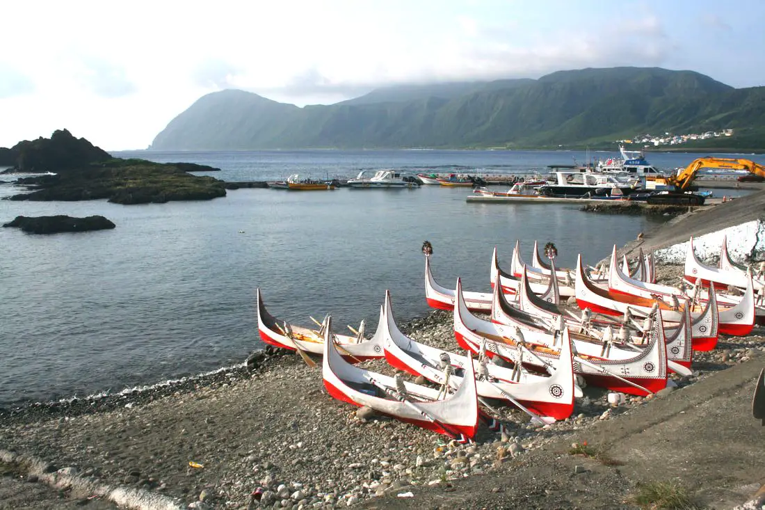
Orchid Island (not to be confused with the Fijian Island of the same name), known in the local Tao language as Ponso No Tao (Island of the people), and in Chinese as Lanyu (蘭嶼) is a secret indigenous people's paradise off the southeastern coast of Taiwan. It is different than any other place in Taiwan, and has the best preserved indigenous culture anywhere in the country. If Taiwan's best tourist activity is experiencing the culture of Taiwan's indigenous peoples, then Lanyu has the best tourist experience anywhere in Taiwan.
Background: History: Orchid Island became inhabited about 800 years ago by the Tao indigenous people (達悟族) (aka Yami people 雅美族, which is a name coined by the Japanese, but the native people prefer Tao), which are thought to have traveled from the Batanes Islands in the Philippines, which are a little less than 200 KM away, cut off by the Bashi Channel. However, Orchid Island is very different than the Philippines. Beginning in1644, some Dutch Sailors were sent to investigate the island, and some settled there among the natives. Because of this, the Island was known as Red Head Island (紅頭嶼) by the Chinese and the Japanese. After the Dutch were defeated in Taiwan, Lanyu was claimed but not controlled by the Qing Dynasty. The Japanese claimed the Island shortly after the Sino-Japanese War in 1895, but protected it as an "ethnological research site" and forbid outsiders from entering. After the Republic of China took over Taiwan following the end of WWII, they continued to ban visitors to the island until 1967, after which tourists were allowed to enter and public schools were built there. Christian missionaries began preaching and living on the island starting in the 1950s, and now basically all native people on the island are Christian (mixed with traditional beliefs). However Christianity was introduced much earlier starting with the Dutch in the 1600s although to a lesser extent. In 1982 a nuclear waste storage plant was built on the south side of the Island without the islanders' consent, causing protests from the inhabitants. Also because of this, the Island inhabitants receive free electricity. The island is volcanic in nature, with the last major eruption being over 5 million years ago. The highest mountain is 552 meters (1,811 feet). Currently there are 2,400 people permanently living on the island, 90% of them being of native Tao descent. Tao Culture: The Tao people number about 2,000 living on Orchid Island, with about another 2,000 living on the Taiwan mainland. The Tao people rely on the sea for survival, and much of their traditions and lifestyle are centered on fishing. The Tao people are mostly Christian but also still practice many of their traditional beliefs. However their ancestral religion included a pantheon of Gods. Traditional roles for men are fishing while roles for women include harvesting taro and sweet potato and weaving. The men usually fish at night or early morning and rest on traditional wooden platforms during the day. Boats are made from planks of wood and are painted red, white, and black. The boat usually has human figures, waves, and the traditional sun image (red and black circles and sun rays) which is said to warn off evil spirits. Boats are considered sacred and the ultimate human creation. There is also a launching ceremony for new boats in which traditional clothes and headgear (such as silver helmets for men and wooden hats for women) are worn, pigs are slaughtered, and the boat is lifted into the air multiple times before being set in the water. Traditional clothes include loin cloths and vests for men, and aprons and vests for women. Young people on the street usually do not wear traditional dress. Flying Fish Festival: There are three basic seasons on Lanyu: one is the flying fish season when flying fish can be easily caught and used and lasts from February to May. The other seasons are from May to October and October to February, when flying fish cannot be caught for ceremonial use. There are many taboos during flying fish season which are discussed below. The Flying Fish Festival lasts from aboutMarch to October when flying fish are caught. During this time many ceremonies take place such as for the beginning of the festival, plentiful harvest, etc. During the festival, there are multiple migrations of flying fish species near Lanyu. There are many taboos during this time, especially when it comes to catching and eating flying fish which are the main life source of the Tao people. Weather and Climate: The island has a tropical rainforest climate, with average high temperatures between 20 and 30 degrees year round. The rainy months are in summer, especially due to Typhoons, but the most sunny days are also in summer (expect a lot of sun), and the most rainy days are in winter. Summer is the tourist season, but spring and fall are also popular times to visit. Winters are said to be dreary, cold, and have constant northeastern winds that can stop airplanes and ferries from departing to the island. When to go: The best time to go they say is around May when it is not too hot and there are no northeasterly winds or typhoons which can cancel your transportation to the island. Typhoon season lasts from around June to October. The busy season is during summer break from June to August, during which time it can be hard to book a hostel or airplane ticket. Winter is the less crowded season, but the water will be cold, there will be constant wind (which could cancel transportation), and it will rain more often. Taboos: General Taboos:
How to get there: By Plane: You can book discount air tickets from Taipei to Taitung on KKday here. The only planes to and from Orchid Island come from Taitung. Flight times: As of the time of this blog, there were six flights per day byDaily Air Corporation from about8 AM to 4 PM (Please note their website is only in Chinese). The flight from Taitung to Lanyu takes about 25 minutes. Please note that the aircraft are small and flights can be cancelled due to high winds or unfavorable weather. Costs: NT 1428 to Lanyu and NT 1360 from Lanyu. You can purchase plane tickets through a tour agency such as Klook or a similar website. By Boat: There are two places that offer ferry rides to Lanyu: Houbihu Harbor (恆春後壁湖漁港) in Pingtung and Fugang Harbor in Taitung (臺東富岡漁港). There are also two ferry companies that operate at both harbors. Both companies leave from both harbors at the same time and arrive at the same time for the same price (2300 NT per person round trip/1150 NT per single trip). Ferry Boat costs: 2300 NT per person round trip (1150 NT per single trip)from both Taitung and Pingtung. Both ferry companies have the same price. Ferry Boat Times: 7:30/7:00 AM departure, 9:30 AM arrival to Lanyu. 12:00/12:30 PM departure, 3:00 PM arrival to Lanyu. 9:30 AM departure from Lanyu, 11:30 arrival to Taitung or Pingtung. 3:00 PM departure from Lanyu, 5:00 PM arrival to Taitung or Pingtung. Both ferry companies depart and arrive at the same time to both locations. You can purchase ferryboat tickets for a discount on Klook here or KKday here. Getting around the island: Rent a scooter! The island is small so you should not need to rent a car. You can rent bicycles but you will not be able to travel as fast. You can also hire a driver to take you on tours. Ask your hostel for more rental information. They can help you book a rental in advance. Tours: You can book multiple tours and activities such as a Tribal Tour, Underground House Tour, day hiking, night hiking, snorkeling, scuba Diving, SUPing / Paddle Boarding, and Freediving. You can search for more tours through Klook here or KKday here. Scooter Rental: Price: expect 500 NT per day. You can book a scooter through Klook here or KKday here. Be sure to book your rental in advance, especially during summer weekends. Ask for help from your hostel owner if needed. I am 100% percent certain you do not need a Taiwan local license to rent scooters here, however they may ask for an international license (but I'm fairly sure they will let you rent without one). Helmet wearing is not enforced at all as you will quickly find, but it's still the law. Also be careful to not hit any goats because they wander as they please. There is only one gas station next to Kaiyuan Fishing Harbor. Car Rental: Price: expect 2000 NT per day. You can rent a car for Lanyu on KKday here. Bicycle Rental: Price: Bike rental is about 400 NT per day. You can rent a bike for Lanyu on KKday here. Accommodation: Booking accommodation on the island can be difficult in summer months and on weekends, when rooms can be fully booked for months in advance. There is a nice selection of rooms on Agoda. Here is a list of every registered hostel on the island, but it is in Chinese. My hostel required that I pay for my room in advance via bank wire transfer (this may not be an option if you are a foreign traveler, so make sure they accept credit cards if you do not have a Taiwan bank account). Expect to pay 2000 - 4000 NT per night for a standard double room on Lanyu. You can also book Wifi and SIM cards for Taiwan on Gigago here. Just to let you know, if you book using the links above, we get some commission at no cost to you, and you can help support our blog. You can click here to receive $5 USD on your first Klook purchase. Map: Please see below: 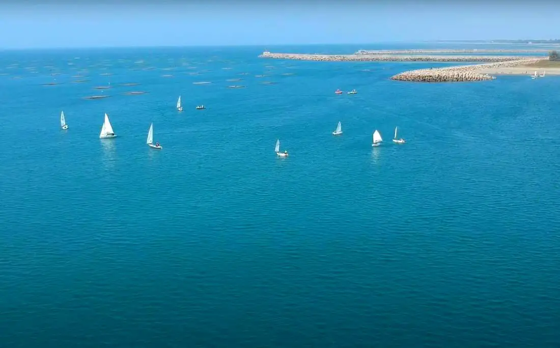
A sailing class going on off Tainan's Yuguang Island.
With over 100 islands and a coastline of over 1500 KM on the main Island, warm tropical weather, and constant winds, Taiwan is known as a world-class sailing location. Sailing in Taiwan can be an exhilarating experience that provides a unique perspective on the island’s stunning coastline and surrounding waters. With its rich history and culture, Taiwan has become a popular destination for adventure seekers and travelers looking to explore its natural beauty via sailboat.
Brief Historical Background of Sailing in Taiwan: Even though Taiwan has thousands of islands and hundreds of kilometers of coastline, it still does not have a strong sailing culture as compared to other countries. The recreational boating industry in Taiwan only really began in 2009, when the Fisheries Agency began making floating docks for more recreational craft. Those docks are now filled to capacity, so prices are on the rise and demand is high. Boat owners are hopeful that Taiwan's authorities can further expand recreational marinas in Taiwan soon. Non-powered sailing in Taiwan is regulated by the coast guard, but all you have to do is send your itinerary to the coast guard via a smartphone app. Where to Sail in Taiwan: 
Guishan Island (literally Turtle Mountain Island) is a turtle-shaped island off the coast of Yilan in Eastern Taiwan. Once inhabited by fishermen, it is now a coast guard base but is open for day tours. The island tour includes beautiful sea cliffs, hiking, a lake, an abandoned village, military tunnels, and whale watching just offshore.
Background: Turtle Island has been inhabited since at least the Qing Dynasty. When the ROC took over Taiwan, the island had one elementary school and no hospital. Many people relied simply on religion to cure their sicknesses. During typhoons, the dock would sometimes be destroyed, leaving the island without food for days or weeks. Also, there were way more men on the island than women, and it was hard to convince prospective wives from Taiwan to go live on such a remote island with harsh conditions. As a result, the government relocated everyone living on Turtle Island to the main island of Taiwan in Toucheng township of Yilan in 1977. The people could have chosen to stay, but they went without protest. The ROC then made the island into a restricted military base. In 2000, the Island was opened for tourism, the military aspects of the island were phased down, and it was made into an ecological reserve. Now the island allows Tourists to come during the day, but no one is allowed to stay overnight. Tours and Prices: Whale watching on a boat around the island: 800-1000 NT per person. Once around the island on a boat and 2-hour tour of the island: 800-1000 NT per person. Whale watching and island tour: 1200+ NT Island tour including hiking to the top of the island: 1200+ NT You can book a personalized tour and ferry boat tickets with Klook or KKday. You can purchase tours and tickets for many activities in Yilan such as surfing, kayaking, horse riding, river tracing, river rafting, river tubing, pack rafting, water biking, snorkeling, canoeing, and many others through Klook here or KKday here. Hours: 2-4 hour tours start from 8:00 AM or later and end in the afternoon until about 4:00 PM. When to go: March-November. These tours are generally closed from December to February due to rough seas and cold weather. Accommodation: There are not hotels on Turtle Island and staying overnight is forbidden. Looking for a hotel? We recommend booking through Agoda here, which provides the best quality selection of accommodation on the islands. Find out where to stay in our Taiwan hotels guide or search for the best hotel deals in Taiwan here. We have stayed at and recommend Jiaosi Hotspring Hotel, a hotel with hot springs in each room (you can book on Agoda here, Booking.com here, Hotels.com here, Expedia here, or Trip.com here). We have also stayed at Toucheng Leisure Farm, a recreational farm and experience center in Toucheng (you can book on Agoda here, Booking.com here, Hotels.com here, Expedia here, on Klook here, or on Trip.com here). You can also book Wifi and SIM cards for Taiwan on Gigago here. Need travel insurance? Compare prices on Insubuy here. Just to let you know, if you book using the links above, we get some commission at no cost to you, and you can help support our blog. You can click here to receive $5 USD on your first Klook purchase. How to get there: The only way to get there is by boat from Wushih Harbor in Yilan. To get to Wushih Harbor from Taipei, you can take the TRA train to Toucheng station, and then take a taxi from there. Otherwise, you can drive on National Highway 5 to Toucheng; there is free parking at the harbor (drive to the very end of the harbor). You can purchase a ticket at the harbor or book online in advance via Klook or KKday. Map of Guishan Island: 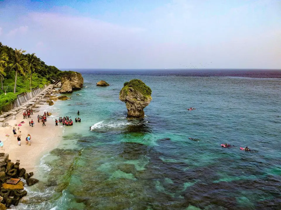
Xiaoliuqiu (aka Little Liuqiu, Lamay Island, or Lambai Island) is a small island paradise off the southwestern coast of Taiwan. The island is known for its clear water, amazing coral reefs, white sand beaches, and quiet laid back atmosphere. Only a short half hour boat ride from the Taiwan mainland, the island is easily accessible. In addition, the island is small enough that you can round the entire island by scooter in a matter of minutes.
Background: In 1622, a Dutch ship crashed on the island, two years before the Dutch began to rule Taiwan, and all but one of the crew members were killed by the aboriginal tribe living on the island at the time. In retaliation, the Dutch sent a force to massacre the natives on the island. 300 men, women, and children were suffocated alive in a large cave, and the rest of the people were put into slavery by the Dutch. This was known as the Lamey Island Massacre. Later Chinese people began inhabiting the island in 1645. Later the island fell into Qing, Japanese, and ROC rule. Currently the island is a township of Pingtung County with a population of over 10,000 people. Most of the people on the island rely on fishing and tourism for a living. The island also has one of the largest concentrations of temples in Taiwan. Xiaoliuqiu started to become a major tourist destination after 2004, reaching over 400,000 tourists per year. Regulated Inter-tidal Zones: in 2015 restrictions were placed on the inter-tidal zones in Xiaoliuqiu so that only those with a licensed guide could visit them and swimming is prohibited. These restrictions apply specifically to the Dafu Harbor inter-tidal zone (north of Dafu Harbor), Yanziping Beach, and the Shanfu Harbor Inter-tidal zone (north of Shanfu Harbor). Although there are other inter-tidal zones, these are not regulated. When to go: Anytime! Xiaoliuqiu is a tropical island that has warm water and temperatures (above 25 degrees Celsius) year round. However it is a little cooler and more windy during the winter, and you should be sure to avoid Typhoons during summer (ferries will be cancelled if there is a Typhoon). However, it can get really crowded during summer break in July-August, so go during the off-season to avoid the crowds. Tours: You can book multiple tours such as snorkeling, scuba diving, SUP experience, Kayak Sailing, submarine ride, and more through Klook or KKday, such as the Xiaoliuqiu Experience Pass. Booking a hotel: Booking accommodation on the island can be difficult in summer months and on weekends, when rooms can be fully booked for months in advance. Some places we have stayed at that I recommend are Yujing 6.8, which is a four story house near Dafu Harbor (you can book on Agoda here or Booking.com here), Boliu B&B (柏琉民宿) which is also a nice newly renovated hostel right on the main street near lots of restaurants (you can book on Agoda here or Booking.com here), Haichan Hostel which is a traditional three-sided Taiwanese mansion near the beach (you can book on Agoda here or Booking.com here), and Baisha Bay B&B which is a great place near the main harbor that is only one story so there are no stairs (you can book on Agoda here or Booking.com here). All of the owners of these places were very helpful, and even helped me to move my luggage and rent scooters. Some hostels require that you pay for my room in advance via bank wire transfer (this may not be an option if you are a foreign traveler, so make sure they accept credit cards if you do not have a Taiwan bank account), but you should not have to do this if you book through Agoda or another hotel booking site. Looking for a hotel? Find out where to stay in our Taiwan hotels guide or search for the best hotel deals in Taiwan here. You can also book Wifi and SIM cards for Taiwan on Gigago here. Need travel insurance? Compare prices on Insubuy here. Just to let you know, if you book using the links above, we get some commission at no cost to you, and you can help support our blog. You can click here to receive $5 USD on your first Klook purchase. How to get there: The only way to get there is via ferry from Donggang's Dongliu Ferry Terminal. The ferry ride takes about 30 minutes. There is a ferry leaving from Donggang roughly every hour from 7 AM to 5 PM. You can purchase a tickets at Donggang Fishing Harbor (東港漁港), or through a tour agency such as Klook here or here, or KKday. Parking: There is free scooter parking and paid car parking at the fishing harbor (30 NT per car), but the fishing harbor does not allow overnight parking. Overnight parking near the fishing harbor can cost up to 180 NT per day, so consider parking further away if you want to save money on parking. Public transport: There are many shuttles to and from Zuoying HSR station that leave hourly. The cost is about 200-300 NT per trip. You can book discounted HSR tickets on Klook here. You can book a shuttle from Zuoying to Donggang on Klook here. Scooter Rental: Price: expect 300-400 NT per day. You can book a scooter through Klook here or KKday here. You can also check out our scooter rental guide here. Be sure to book your rental in advance, especially during summer weekends. Ask for help from your hostel owner if needed. Helmet wearing is not very much enforced, but it's still the law, and you should definitely wear one for your own safety. Bicycle Rental: Looking for bicycle rentals in Taiwan? You can search on KKday here and search for tours on Klook here. You can also check out our Taiwan cycling guide here. Price: Ferry ride: about 410 NT per round trip, about 30 minutes. The public ferry goes to Dafu Fishing Harbor (大福漁港), and private ferries go to Baishawei Fishing Harbor (白沙尾漁港). There are ferries that leave at least hourly from about 8 AM to 5:00 PM. Scooter rental: about 300 NT per day. There is a gas station on the back side of the island. Snorkeling: about 300 NT per hour Scuba diving: around 2500 NT for 2-3 hours SUP experience: About 1000 NT for half a day. Kayak Sailing experience: about 2000 NT for 2 hours. Submarine adventure: about 2000 NT. You can purchase a tickets at Donggang Fishing Harbor (東港漁港), or through a tour agency such as Klook here or here, or KKday. Map: Please see below: 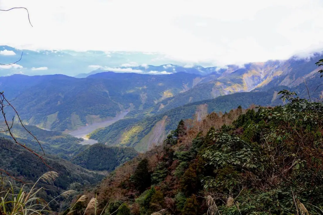
Taipingshan (aka Taipingshan National Forest Recreational Area 太平山國家森林游樂區) is a magical mountain paradise in Datong Township of Yilan County in Taiwan. It has an old Japanese era logging railroad track which has mostly been abandoned, but part of it has been restored with a working train. In addition there are hot springs, Taiwan's largest alpine lake, hikes, wildlife, and endless mountain scenery to explore.
Background: In 1906, the Japanese Indigenous affairs police officers sent a team of men to Fanfan Mountain, where they discovered huge ancient cypress trees. Later the Japanese renamed the area Taipingshan, and began logging the mountain in 1915. The Taipingshan Forest Railway was completed in 1934 and had at least 12 stations, with the grade up the mountain ranging from 2-3%. Loggers relied heavily on wires and pulley systems to haul logs to the railway, which differentiates it from the Alishan Railway. Because of the extensive use of wires or iron donkeys, it was difficult to convert the entire railway to a tourist railway, therefore only a short section at Maosing remains for tourists. The logging industry continued in Taiwan until it was banned in the 1980s, after which the area was converted into a forest recreation area in 1983 and opened to the public. The mountains in Taipingshan range from 500 to 2000 meters high, and is part of the northern central mountain range. The highest peak here is Nanhu Mountain at 3,740 meters high. The terrain generally consists of high mountains and deep valleys, which have been pushed up by the convergence of the Eurasian and Philippine plates, and eroded by torrential rains. Taipingshan is 12,929 hectares, and includes six major areas: Tuchang, Jioujhihze, Jhongjian, Taipingshan, Maosing and Cueifong Lake. Taipingshan holds the record for 24 hour rainfall in Taiwan of 1015 mm, recorded in 2016 during Typhoon Megi. The area is also one of the most accessible places in Taiwan to see snow during winter. The forest recreation area is now a popular place for nature enthusiasts and hikers, and is one of the top three most popular forest recreation areas in Taiwan. Hours: 6 AM to 8 PM (open 4 AM on weekends) Price: 150 NT for non-holidays, 200 NT for holidays Cars: 100 NT Scooters: 20 NT Jioujhize Hot Springs: 250 NT in winter and 150 NT in summer Bong Bong Train: 180 NT You can buy a discount entrance ticket to Taipingshan on KKday here or book a tour on Klook here. Website: https://tps.forest.gov.tw/ Tours and Activities: You can purchase tours and tickets for many activities in Yilan such as Su'ao Crayon Castle, Turtle Island, Lanyang Museum, Toucheng Leisure Farm, Zhang Mei Ama Capybura Farm, Bambi Land, Yinong Ranch, National Center for Traditional Arts, Taxi Museum, Glamping, Camping, ATV / 4-wheeling experience, SUP / paddle boarding, Ximeng Forest Theater, Surfing, Kayaking, Horse Riding, River Tracing, River Rafting, River Tubing, Pack Rafting, Water Biking, Snorkeling, Canoeing, Shrimping and many others through Klook here or KKday here. Accommodation: Looking for a hotel? We recommend booking through Agoda here, which provides the best quality selection of accommodation on the islands. We have stayed at and recommend Ying Shih Guest House, a resort in Datong Township near Taipingshan and Fan Fan Hot Spring (you can book on Agoda here or Booking.com here), and Jiaosi Hotspring Hotel, a hotel with hot springs in each room (you can book on Agoda here, Booking.com here, Hotels.com here, Expedia here, or Trip.com here). We have also stayed at Toucheng Leisure Farm, a recreational farm and experience center in Toucheng (you can book on Agoda here, Booking.com here, Hotels.com here, Expedia here, on Klook here, or on Trip.com here). You can also book Wifi and SIM cards for Taiwan on Gigago here. Need travel insurance? Compare prices on Insubuy here. Just to let you know, if you book using the links above, we get some commission at no cost to you, and you can help support our blog. You can click here to receive $5 USD on your first Klook purchase. How to get there: By Bus: Kuo-kuang departs from Yiland and Luodong at 7:40 and 8 AM, and arrives at Taipingshan at 10:30 AM. The bus then departs Taipingshan at 2:30 PM. You can book tickets to travel to Yilan via inter-city bus on Klook here. You can book tickets to Yialn via high speed rail (HSR) on Klook here or KKDay here. Book tickets via the normal train (TRA) on Klook here. Bicycle rental: Cycling is the best way to enjoy Taiwan's landscapes if you have the time and energy. Looking for bicycle rentals in Taiwan? You can search on KKday here and search for tours on Klook here. You can also check out our Taiwan cycling guide here. By Car/Scooter: From Taipei, take National Freeway 5 to Yilan, then turn southwest on provincial highway 7 until you reach the turnoff to Taipingshan via Yijhuan Route 1. Looking for scooter rental in Yilan? You can search Klook here or KKday here to look for options. You can also check out our scooter rental guide here. If you are looking for car rentals in Yilan, you can also search Klook here or KKDay here. You can also check out our car rental guide here. Map: Please see below of the places covered in this blog: 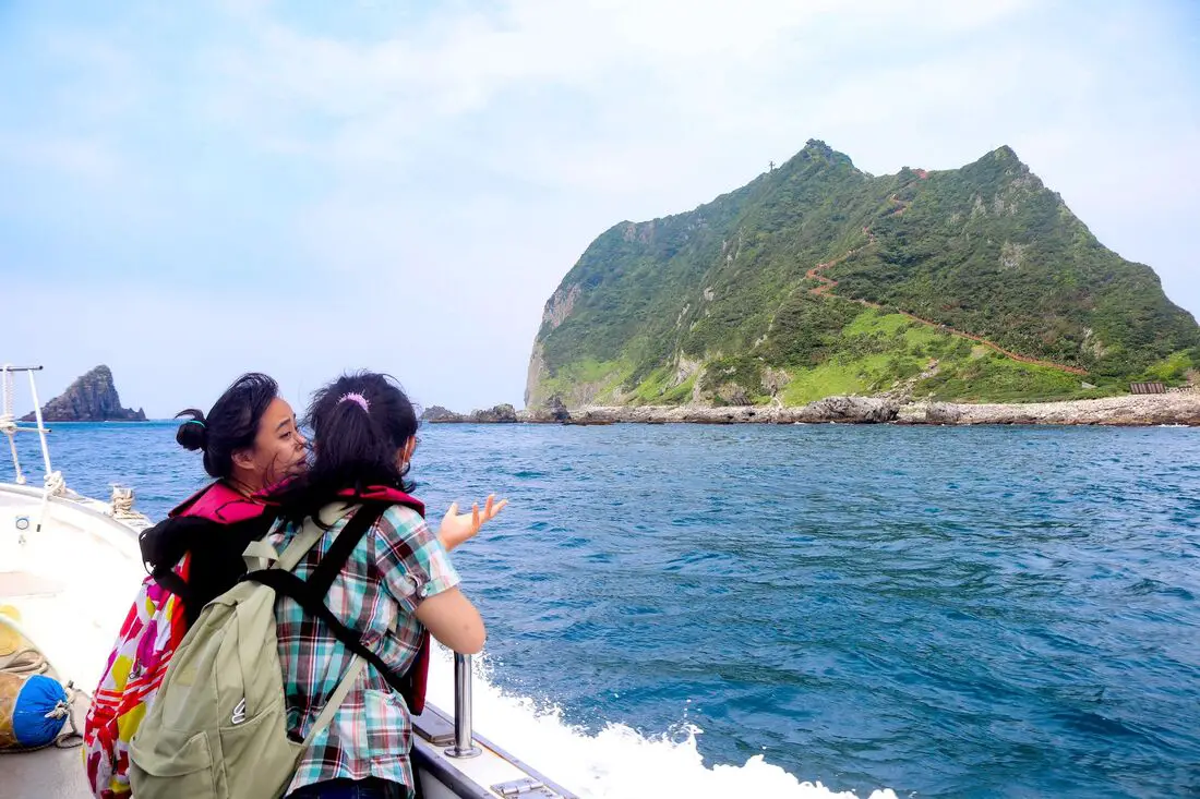
Keelung Islet is the tall, rocky island off the coast of Keelung City that has recently been reopened to tourists. The island features a trail to the lighthouse at the highest peak that provides breathtaking views of the surrounding area. Just a short trip from Taipei, and then a 20-minute boat ride, it is one of the most accessible outer islands that you can visit in Taiwan.
Background: Keelung Islet is a volcanic remnant dating back to the Pleistocene era about 1 million years ago and is part of the Ryukyu Volcanic Arc which is formed from the subduction of the Philippine Sea Plate under the Eurasian Plate. After the volcano was formed, it was slowly eroded away by wave action, creating a steep mountain peak with sides at about a 60-degree angle. The island is 182 meters tall (597 feet), 960 meters long (3139 feet), and 400 meters (1312 feet) wide. Except for crabs, birds, lizards, and insects, the island remained uninhabited until the Japanese stationed troops here during the colonization of Taiwan. After the ROC took control of Taiwan, the island continued to be a military base. In 1980, the Keelung Islet Lighthouse was completed. It was the first lighthouse in Taiwan built in an octagonal shape, and the first powered by solar power and batteries. The islet was opened to tourists in 2001, however, tourism to the island was stopped in 2014 after Typhoon Maria ravaged the island, and was closed for five years until 2019. Currently, the island is open to tourists, but you cannot stay overnight there. The only people that live on the island are members of the coast guard who stay there on a rotational basis. Tourist boats take off daily from Baodouzi Harbor from April until October, and the island is closed to tourists during the winter months due to strong northeasterly winds. The island is popular especially on weekends during the summer, but only 1200 people are allowed to visit each day, so you may have to book in advance. Hours: Boats to Keelung Islet leave at about 8 AM, with the last boats leaving at about 1 PM. Everyone has to be off the island before sundown. Each trip lasts about 3-5 hours depending on the itinerary. You can book boat tickets on Klook here or KKday here. Boats to Keelung Islet are only available from April to October due to northeasterly winds in the winter. Price: Boat trip to the island and hike to the lighthouse: about 700 NT Boat trip to the island, lighthouse, and other places such as elephant trunk rock: about 1200 NT Again, you can book tickets on Klook here or KKday here; booking on these sites is usually cheaper than buying tickets in person. When to go: Boats to Keelung Islet are only available from April to October due to northeasterly winds in the winter. If you visit from May - June you will be able to see white lily flowers, and August to September is golden spider lily season. How to get there: In order to get to Keelung Islet, you first need to make your way to Badouzi Harbor (see map below). By Car/Scooter: Drive to Keelung, then from downtown take provincial highway 2 East about 10 KM until you reach the turnoff to Badouzi Harbor, and there is some paid parking in front of the harbor. If you are looking for car rentals, you can also search Qeeq here, Klook here, or KKday here. You can also check out our car rental guide here. Looking for scooter rental in northern Taiwan? You can search on Klook here or KKday here to search for options. You can also check out our scooter rental guide here. By Train/Bus: Take the TRA to Badouzi (八斗子) station, then walk about 1 KM northwest until you reach the Badouzi Harbor. You can purchase a discount easy card to use on the MRT and buses from Klook here or KKday here. You can also book an MRT travel pass on Klook here. By Ferry: Next you have to take a boat to the island. There are multiple ferry boats running to Keelung daily from April to October. You can book tickets on Klook here or KKday here. Hotels in Keelung: We recommend Just Live Inn-Keelung and Yung Feng Hotel, which are two great quality hotels for a reasonable price in Keelung's City Center. You can book Just Live Inn-Keelung on Booking.com here, Agoda here, Klook here, Hotels.com here, Trip.com here, or Kayak here. You can book Yung Feng Hotel on Booking.com here, Agoda here, Hotels.com here, Trip.com here, Klook here, or Kayak here. Map: 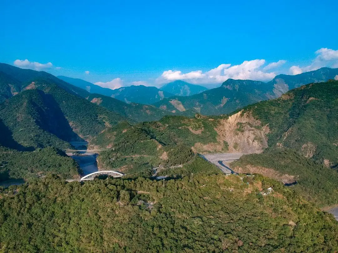
Maolin District of Kaohsiung City is an amazing outdoor paradise and my favorite place in Taiwan. In this mountainous district of Kaohsiung, you can find waterfalls, streams, hot springs, butterflies, aboriginal culture, and great views, all by the roadside! Popular activities include swimming, hot spring bathing, river tracing, camping, and hiking.
Please note I have also finished blogs about Maolin Village, Wanshan Village, Duona Suspension Bridge, and Duona Village (click the links to see each individual blog). Background: During the Japanese occupation, some of the original inhabitants of Maolin Village live in the mountains behind Wanshan Village. However later these aboriginals were forcibly moved to the current village. Many of the inhabitants were originally located elsewhere, but had to relocate their home or village due to typhoons or unsafe terrain. There are a few abandoned villages above the current village that you can still hike to. The villages have about 2000 total inhabitants, mostly aboriginals from the Rukai (魯凱族) Wulu Bunun (布農) and Paiwan (排灣) tribes, as well as some Han Chinese people. The district also has Maolin Middle school, the only middle school, and three elementary schools. Wanshan has the smallest population of any village in Taiwan according to the government website here, with a population of just 450 people. 95% of the people are aborigines from the Rukai Tribe (魯凱族), and the rest are either from the Wulu Bunun Tribe (布農) or Han Chinese. Originally the people of Wanshan village lived at the base of Mali Mountain (麻里山), but were moved by the government in 1956 to their current location. Many of the inhabitants of Maolin were originally located elsewhere, but had to relocate their home or village due to typhoons or unsafe terrain. There are a few abandoned villages around Maolin that you can still hike to. Typhoon Morakot brought record floods to Taiwan because it slowly moved over the island delivering torrential rain. Nearly 700 people were killed during the disaster (to see what Maolin looked like right after the flooding, check out this blog here). Basically all the bridges in Maolin were destroyed during Typhoon Morakot in 2009 except Duona Suspension bridge which is built so high that it would never be affected by floodwater. Most all the bridges currently in Maolin were reconstructed after the 2009 floods. Duona is the most remote village in Maolin District of Kaohsiung City, and is said to harbor the most complete version of the Rukai Aborigine culture. The Rukai People first began to move into the area now known as Duona about 300 years ago (1700s), making it one of the oldest aborigine villages in Taiwan. Most of the people live in traditional stone houses made from nearby plentiful shale rock, which are characteristic of the Rukai Tribe. The stone houses are warm in the winter and stay cool during the summer. Near the village is a small plain which is said to be the home of Taiwan's indigenous species of black rice. The village was almost completely cut off from the outside world until the Japanese built the Duona Suspension Bridge, which helped to link it to the rest of Taiwan as well as better control the native population. The actual Distrcit boundaries extend to Pingtung County and Taitung County, and include largely untouched and "virgin" forests and mountain wilderness areas such as Shuang-guei Lake, providing precious wildlife habitat for many of Taiwan's indigenous animals and plants. Price: Free Hours: 24/7 When to go: I recommend going in the summer time when the waterfalls have plenty of water and warm temperatures make it a great time to go swimming. In winter it will be cold and the waterfalls can dry up. On the other hand if you want to go just for hiking, winter would be a better time to go. If there is a Typhoon, the inhabitants of Maolin will be evacuated, and you should not try to go in for your own safety. If you are coming to see butterflies, the butterfly migration is in the fall and ends roughly in November. How to get there: By Car: Maolin can be reached via provincial highway 27 from Pingtung or Liugui. Once you come to Dajin Bridge, go straight up the mountain. Looking for scooter rental in Kaohsiung? You can check out Klook here or KKday here to search for options. You can check also out our scooter rental guide here. If you are looking for car rentals, you can search Qeeq here, KKday here, or Klook here. You can also check out our car rental guide here. By Bus: You can take a bus there but I don't recommend it. It's a 3 hour bus ride from Pingtung Bus Station. If you can rent a car or scooter it is about a 1 1/2 hour drive from Kaohsiung. You can book tickets to travel to Kaohsiung via inter-city bus on Klook here. You can book tickets to Kaohsiung via high speed rail (HSR) on Klook here or KKDay here. Book tickets via the normal train (TRA) on Klook here. You can also book a Kaohsiung Travel pass here. Accommodation We have stayed at and recommend Chao She Hotel (you can book on Agoda here, Booking.com here, Hotels.com here, or Expedia here) IHI Sanduo Travel Hotel (you can book on Agoda here, Booking.com here, Hotels.com here, or Expedia here), and Mingli Hotel (you can book on Agoda here, Klook here, or Hotels.com here) which are three inexpensive and high quality choices in downtown Kaohsiung. I also have stayed at and recommend Kaohsiung Meinong Rabbit Paul Homestay B&B (you can book on Agoda here, Booking.com here, or Trip.com here), a quiet B&B in rural Meinong, and Chengching Lakeside Resort (you can book on Agoda here, Booking.com or Trip.com here)and the Grand Hotel Kaohsiung (you can book on Agoda here, Booking.com here, Hotels.com here, or Expedia here) which both offer breakfast buffet and free entrance into Chenqing Lake Park. I have also stayed at the 85 sky tower which offers great views of the city; you can search for rooms in the 85 sky tower on Agoda here, Booking.com here, Hotels.com here, Expedia here, or Trip.com here). Find out more about where to stay in our Taiwan hotels guide or search for the best hotel deals in Taiwan here. We recommend booking through Agoda here, which provides the best quality selection of accommodation on the islands. You can also book Wifi and SIM cards for Taiwan on Gigago here. Need travel insurance? Compare prices on Insubuy here. Tours: You can find more tours and activities in Kaohsiung such as Pier 2, Meinong Hakka Museum, Hamasen Railway Museum, Suzuka Circuit Park, i-Ride Kaohsiung Visual 5D Flying Theater, National Science and Technology Museum , Senya Village Restaruant, Austin Land, Ski School Indoor Ski Slope, and many more on Klook here or KKday here. Just to let you know, if you book using the links above, we get some commission at no cost to you, and you can help support our blog. You can click here to receive $5 USD on your first Klook purchase. Map: Please see a map below marked with all the destinations we will visit in this blog: 
Taiwan's northern coast is an amazing, beautiful area with unique geology and rocks, lots of sandy beaches, amazing mountain views and hikes, old streets, night markets, historical sites, and much more to discover. Don't not come here.
Brief Historical Background: The sandstone that forms Northern Taiwan was created between 10 and 20 million years ago and was pushed out of the sea along with northern Taiwan thousands of years ago. Sediment under the ocean millions of years ago was uplifted thanks to the collision of the Eurasian and Philipine plates. The rocks have then been slowly eroded away by wind and water, creating odd shapes that you see today. You can see similar formations at Yehliu Geopark. What is now Keelung and Taipei was once part of Basay aborigine lands. The area around Yilan was inhabited by the Ketagalan Aboriginal tribe, whose language is now extinct. The name Yilan comes from this language. Chinese settlers from Fujian began living in the Taipei Basin during the Dutch rule in the 1600s. Keelung was first settled by the Spanish in 1626, as their first settlement in what became their rule of northern Taiwan until they were defeated by the Dutch and left Taiwan in 1642. The Qing Dynasty then ruled western Taiwan starting from the late 1600s. The capital of Taiwan was moved to Tainan. In 1891, the first train connecting Keelung and Taipei was completed. During this time, the Qing Dynasty built many forts near Keelung in response to the Opium Wars and the Sino-French War. During the Japanese Era, the capital of Taiwan was moved to Taipei and a round-island railway was completed. Currently a High-Speed Rail extension is planned for Yilan, and is expected to be completed by 2036. The northern coast of Taiwan is a popular weekend destination for the nearly 8 million people who live in the greater Taipei area. Basic Taiwan Travel Tips:
When should you go to Taiwan's Northern Coast? In my opinion, the best weather in Taipei is from March-May, and October - November, when the temperatures stay around 26 degrees Celsius and there is not as much rain. Summers are also nice, with the most sunny weather, but also hot and rainy. Winters can be cold (but not below freezing) and usually wet. Overall, there is no wrong answer as to what time of year you should visit Taipei. You will have a great time here at any time of year. Hotels on Taiwan's Northern Coast: We recommend Fullon Hotel which has locations in Tamsui and Fulong near the beach (book on Booking.com here, Tripadvisor here, Agoda here, or Hotels.com here). We have stayed at and recommend Gold Mountain Ranch, which is a horse ranch and glamping destination in Jinshan. You can book a night at Gold Mountain Ranch on Klook here. You can also check out our full blog on the ranch here. We have also stayed at and recommend Hai Xia Your Home which is right in front of Fulong Beach (book on Booking.com here, Tripadvisor here, Agoda here, or Hotels.com here). Looking for a hotel? We recommend booking through Booking.com here, which provides the best quality selection of accommodation in Taiwan. Find out where to stay in our Taiwan hotels guide or search for the best hotel deals in Taiwan here. Tours of Taiwan's Northern Coast: There are many tour itineraries that you can enjoy along Taiwan's Northern Coast that will take you to multiple destinations and arrange transportation. For more information, you can check out Tripadvisor here, KKday here, or Klook here, which are both great tour websites that can connect you with the right tour and tour guide for you. Here are some of the most popular tours of Taipei on Tripadvisor:
You can book a customized tour of Taiwan's North Coast on TripAdvisor here, Klook here, or KKday here. Attractions along Taiwan's Northern Coast: There are many attractions that you can enjoy along Taiwan's Northern Coast such as Yehliu Ocean World, Yehliu Geopark, National Museum of Marine Science and Biology, Heping Island Park, Ju Ming Museum, New Taipei Gold Museum, Futian Leisure Farm, Fort San Domingo, 13 Levels Archaeology Museum, Bat Cave, Candlestick Islet, Activities along Taiwan's Northern Coast: Don't forget that there are many activities available along Taiwan's Northern Coast such as Wakeboarding, Surfing, Speedboat Surfing, SUP / Paddle Boarding, Diving, Snorkeling Kayaking, Canoeing, Water Biking, River Tracing / Canyoneering, ATVing, Horse Riding, Archery, Tree Climbing, Glamping, Motorcycling, Motorbike Tour, Dragon Boat Racing, Shen'ao Rail Bike, and more on Tripadvisor here, Klook here, or KKday here. Just to let you know, if you book using the links above, we get some commission at no cost to you, and you can help support our blog. Some of the Klook links may not work if you are using an Ad blocker. You can click here to receive $5 USD on your first Klook purchase. How to get there: The only way to get to Taiwan is via airplane. Planes leave daily from Taipei's Songshan and Toayuan Airport. Taoyuan Airport: Taoyuan is Taiwan's largest airport and typically has cheaper flights and more flight times to choose from. It's about an hour's journey from Taoyuan Airport to the center of Taipei. You can travel via MRT, HSR, bus, or taxi to get to Taipei. You can get 30% off the Taoyuan Airport VIP lounge on KKday here. Songshan Airport: Songshan is a small airport in Taipei's city center, and can be a convenient option for people traveling within Asia. The airport is right on the Taipei MRT brown line. You can book cheap flights to Taiwan on KKday here, Trip.com here, CheapO Air here, or Kiwi here. How to get around Taiwan's Northern Coast: Northern Taiwan's transportation system is convenient and safe. There are many options you can consider to get around along Taiwan's Northern Coast below: By Train: Gets you to Keelung, Fulong, and Yilan along the north and east parts of the North Coast. Book tickets via the normal train (TRA) on Klook here. By MRT: (Mass Rapid Transit, Metro train, subway) – Easily gets you around Taipei and Tamsui. You can purchase a discount easy card to use on the MRT from Klook here or KKday here. You can also book an MRT travel pass on Klook here. By Bus: Buses run along the entire northeast coast, but they may be slow and there may not be many busses during weekdays. You can also book tickets to travel to Shifen via inter-city bus on Klook here. You can also book a Taipei Sightseeing: Hop On, Hop Off Open Top Bus on TripAdvisor here. By Taxi: You can take short rides for about 150 NT, or hire a Taxi for a day for around 150 USD. You can search for private chartered cars on KKDay here. By Car: If you are looking for car rentals, you can also search Qeeq here, Klook here, or KKday here. You can also check out our car rental guide here. By Scooter: Looking for scooter rental in northern Taiwan? You can search on Klook here or KKday here to search for options. You can also check out our scooter rental guide here. By Bicycle: Cycling is the best way to enjoy Taiwan's landscapes if you have the time and energy. Looking for bicycle rentals in Taiwan? You can use Taiwan's many Youbike sharing stations, or search for rentals on KKday here, and search for tours on Klook here. You can also check out our Taiwan cycling guide here. You can also book a cycling tour on TripAdvisor here. For more information, check out our Taiwan transportation guide here. Here is a map of the locations we will cover in this blog: 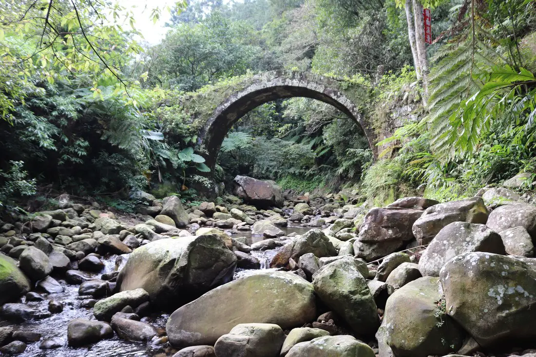
Shiding District is a secret mountain paradise in New Taipei City, in northern Taiwan (新北市石碇區). Lots of people simply pass through here without knowing much about what there is to see. In this guide I will show you some of the secret historical and nature destinations in this amazing place.
Historical Background: The name Shiding comes from boats transporting goods from the area that used to use large rocks (shi 石) in the river as anchors (ding 碇). The Shiding administrative area (石碇堡) was created during the Qing Dynasty and extended from Keelung to Wenshan District. The area around Shiding Old Street was the first area to be developed by Han Chinese in Shiding. In the early days during the Qing Dynasty, the Han Chinese settlers here mainly grew tea and leeks. During the Qing Dynasty, Shiding was an important stop along the Danlan Old Trail (淡蘭古道 which means the road between Tamsui and Yilan), which was split into three paths, and Shiding was on the Southern Path. The Southern Path winded from Mengjia Old Street to Liuzhangli, then to Shengkeng, and onto Shiding which was a major tea producer at the time. From Shiding, the road then went to Pinglin and then Yilan. The Southern path was the quickest way to Yilan. During the Japanese Era until the 1980s, the major industry in the area was coal mining, As the coal mining industry winded down in the 1980s and 90s in Taiwan due to lower worldwide coal prices, the economy in Shiding suffered and many people left. The multi story buildings near Shiding Old street are a testament to the economic prosperity of the coal mining era. Currently Shiding is sparsely populated with the main economic activity including tea farming and agriculture. Tours of Shiding: You can book a tour to Shiding on TripAdvisor here, Klook here, or KKday here. Hotels in Taipei: We have stayed at and recommend the Yuanshan Grand Hotel, once the tallest building in Taiwan and still the most grand (book on Booking.com here, Tripadvisor here, or Agoda here). We have stayed at and also recommend Fu Chang Hotel in Ximending, which is within walking distance of Ximending shopping district (book on Booking.com here, Tripadvisor here, or Agoda here). Looking for a hotel? We recommend booking through Booking.com here, which provides the best quality selection of accommodation in Taiwan. Find out where to stay in our Taiwan hotels guide or search for the best hotel deals in Taiwan here. How to get there: By Car: Go east on National Freeway 5, then get off at the Shiding interchange. Continue east until you reach Shiding Old Street. If you are looking for car rentals, you can also search Qeeq here, Klook here, or KKday here. You can also check out our car rental guide here. By Scooter: From Taipei, take highway 106 east from Shenkeng toward Shiding, pass through Shiding Bao Tunnel, and soon you will come to Shiding Old Street. Looking for scooter rental in Taipei? You can search on Klook here or KKday here to search for options. You can also check out our scooter rental guide here. By Bus: From Taipei City Call MRT station, you can take bus 912 to Shiding High School, after that you will have to switch to bus 666 which will take you all the way to the old street (total about 40 minutes). You can also book tickets to travel to Shiding via inter-city bus on Klook here. You can also book a Taipei Sightseeing: Hop On, Hop Off Open Top Bus on TripAdvisor here. By Bicycle: Cycling is the best way to enjoy Taiwan's landscapes if you have the time and energy. Looking for bicycle rentals in Taiwan? You can use Taiwan's many Youbike sharing stations, or search for rentals on KKday here, and search for tours on Klook here. You can also check out our Taiwan cycling guide here. You can also book a Sunset Riverside Bike Ride and Historical Tour, 4 Hour Cycling in Taipei, Ultimate 8-Hour Cycling City Tour, or Taipei City Bike Tour with Night Market Experience on TripAdvisor here. For more information, check out our Taiwan transportation guide here. Map: 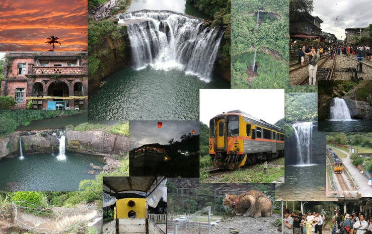
Pingxi District of New Taipei has some of the most popular attractions in Northern Taiwan. With a total of 7 stations along the Pingxi Railway Line (plus 2 if you count Ruifang and Houtong), there are endless places to explore, eat, hike, and enjoy Taiwan's history, culture, and natural beauty all in one place.
Background: Before the Pingxi Railway was built, during the Qing Dynasty a section of the Danlan Old Trail ran through roughly the same area, connecting Yilan to Tamsui. The Japanese completed the Pingxi Railway in 1921 in order to transport coal from the area. Most all of the stations and villages along the line were economically reliant on the coal industry until its downfall in the late 1990s. The coal industry remained strong after the ROC took over Taiwan after WWII, but slowly waned in the 1980s and 1990s due to the decrease in global coal prices. In the year 2000, Sanxia’s Lifeng Mine shut down operations, and Taiwan’s mining company closed, and thus all coal mining in Taiwan effectively stopped. The Pingxi Railway is a single track that is 12.9 KM long with 7 stations. Recently the government has offered many plans to connect the Pingxi Railway to the Taipei MRT via Jingtong to Jingmei, however due to many factors these plans have never been approved. The area around Pingxi and Ruifang is made up of sedimentary rock which easily erodes, creating many large waterfalls such as Shifen Falls, and pointy jagged peaks like the Pingxi Crags. Popular activities along the Pingxi Railway include hiking, river tracing, eating at one of the many old streets, setting off sky lanterns, and exploring the many historical coal mining sites. Hours: The first train reaches Sandiaoling daily at 5:25 AM and the last train leaves Jingtong at 8:33 PM. Price: 80 NT per person for a one day pass. Book tickets via the normal train (TRA) on Klook here. You can purchase a discount easy card to use on Pingxi Railway Line on Klook here or KKday here. You can also book a travel pass on Klook here. When to go: Any time of year is great. However, waterfalls are most enjoyable during the hot summer, and you may want to come for the Lantern Festival when hundreds of sky lanterns are set off at once. To avoid crowds and packed trains, do not go on weekends or holidays. Tours of Pingxi: There are many tour itineraries that you can enjoy in Shifen that will take you to multiple destinations and arrange transportation. For more information, you can check out Tripadvisor here, KKday here or Klook here, which are both great tour websites that can connect you with the right tour and tour guide for you. Here are some of the most popular tours of Pingxi:
Activities Around Pingxi: Don't forget that there are many activities available around Pingxi such as Rock Climbing, Hiking, kayaking, canoeing, snorkeling, SUP / paddle boarding, water biking, Diving, River Tracing / Canyoneering, ATVing, Horse Riding, Cooking Class, photo shoot, Jingtong Sky Lantern Police Station, Shifen Sky Lantern Experience, Waterfall Zipline, Waterfall Diving, and more on Tripadvisor here, Klook here, or KKday here. Hotels on Taiwan's Northern Coast: We recommend Fullon Hotel which has locations in Tamsui and Fulong near the beach (book on Booking.com here, Tripadvisor here, Agoda here, or Hotels.com here). We have stayed at and recommend Gold Mountain Ranch, which is a horse ranch and glamping destination in Jinshan. You can book a night at Gold Mountain Ranch on Klook here. You can also check out our full blog on the ranch here. We have also stayed at and recommend Hai Xia Your Home which is right in front of Fulong Beach (book on Booking.com here, Tripadvisor here, Agoda here, or Hotels.com here). Looking for a hotel? We recommend booking through Booking.com here, which provides the best quality selection of accommodation in Taiwan. Find out where to stay in our Taiwan hotels guide or search for the best hotel deals in Taiwan here. How to get there: By Train: Take the TRA to Ruifang Station, buy the Pingxi Railway line one day pass, and then switch to the Pingxi Railway line. Get off at any station! Book tickets via the normal train (TRA) on Klook here. You can purchase a discount easy card to use on Pingxi Railway Line on Klook here or KKday here. You can also book a travel pass on Klook here. By Car/Scooter: Take Provincial Highway 2 east toward Pinglin, then get off the main highway once you reach Shifen. You can drive right or left to reach all of the stations on the Pingxi Railway line. But please know there is limited car parking around the stations. If you are looking for car rentals, you can also search Qeeq here, Klook here, or KKday here. You can also check out our car rental guide here. Looking for scooter rental in Taipei? You can search on Klook here or KKday here to search for options. You can also check out our scooter rental guide here. By Taxi: You can take short rides for about 150 NT, or hire a Taxi for a day for around 150 USD on Klook here. By Bus: You can also book tickets to travel to Shifen via inter-city bus on Klook here. You can also book a Taipei Sightseeing: Hop On, Hop Off Open Top Bus on TripAdvisor here. By Bicycle: Cycling is the best way to enjoy Taiwan's landscapes if you have the time and energy. Looking for bicycle rentals in Taiwan? You can use Taiwan's many Youbike sharing stations, or search for rentals on KKday here, and search for tours on Klook here. You can also check out our Taiwan cycling guide here. You can also book a Sunset Riverside Bike Ride and Historical Tour, 4 Hour Cycling in Taipei, Ultimate 8-Hour Cycling City Tour, or Taipei City Bike Tour with Night Market Experience on TripAdvisor here. For more information, check out our Taiwan transportation guide here. Map: Please see below:
Taiwan's outer islands are some of the most beautiful and scenic places in the whole country, and each of them can be considered a secret paradise. You can find the best beaches, snorkeling, and diving on these islands. You can also find rich and important historical sites here. Transportation may be difficult, but you will never regret visiting Taiwan's outer islands, and no trip to Taiwan should be complete without doing it.
In this blog, we will introduce the main outer islands in Taiwan that are open to tourists (there are 166 islands in Taiwan, this blog only covers a few), point out their unique traits, and compare them to each other. This way you can best prepare for your trip to the outer islands, and at the same time know what you are missing out on. All the outer Islands are great, and I highly recommend visiting them all if you can. When to visit:
How to get there:
Where to stay: Looking for a hotel? We recommend booking through Agoda here, which provides the best quality selection of accommodation on the islands. Tours: There are many tours available on the islands, including scooter rentals, boat tickets, and other activities. For more information, book with Klook here or KKday here. Map: Please see a map of the islands covered in this blog below: |
Author 作家I am an American expat who has extensive experience living, working, and traveling in Taiwan. In my day, I had to learn many things about Taiwan the hard way. But I have come to learn that Taiwan is one of the best places in the world for Foreigners to live. This blog does not represent the opinions of every foreigner in Taiwan. I am just trying to help others learn more about this beautiful country. Categories
|
 RSS Feed
