

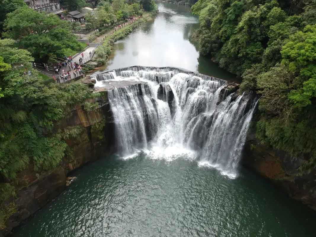
Shifen Waterfall is the widest waterfall in Taiwan, and perhaps the most picturesque in all of Taiwan. It is easily accessible by foot from Shifen Train Station, and includes restaurants, gardens, and suspension bridges along the way. It's spectacular cascading falls are definitely worth a stop for anyone in Taiwan.
Background: Shifen Waterfall is 20 meters high and 40 meters wide (66 x 130 ft.), and is the widest waterfall in Taiwan. It is located near the town of Shifen, which was originally named for the ten families that lived there in the Qing Dynasty, who needed ten portions of goods (Shi = ten Fen = portion). The waterfall lies on the Keelung River which runs through Pingxi and Ruifang, creating a cluster of waterfalls. The rocks here easily erode, making for odd shapes in the riverbed. The waterfall is also known as Taiwan's "Niagra Falls." Before 2010, some government officials illegally charged tickets to see the waterfall. However, since then the waterfall has been made into a park free of any entrance fee. You will also notice that there is a small 1 foot dam on top of the falls. This unnatural feature is according to Taiwan researcher Mike Fagan, "...not a dam, it's a broad-crested weir [that] allows the northern WRA office to calculate flow volume rates." Now you know. Hours: Winter ( October to May): 9 AM -4:30 PM (last people admitted, park open till 5:00 PM) Summer (June to September) 9 AM -5:30 PM (last people admitted, park open till 6:00 PM) Price: Free Tours of Shifen Waterfall: You can book a tour to Shifen on TripAdvisor here, Klook here, or KKday here. There are many tour itineraries that you can enjoy in Shifen that will take you to multiple destinations and arrange transportation. Activities Around Pingxi: Don't forget that there are many activities available around Pingxi such as Rock Climbing, Hiking, kayaking, canoeing, snorkeling, SUP / paddle boarding, water biking, Diving, River Tracing / Canyoneering, ATVing, Horse Riding, Cooking Class, photo shoot, Jingtong Sky Lantern Police Station, Shifen Sky Lantern Experience, Waterfall Zipline, Waterfall Diving, and more on Tripadvisor here, Klook here, or KKday here. Hotels Near Pingxi: We recommend Fullon Hotel which has locations in Tamsui and Fulong near the beach (book on Booking.com here, Tripadvisor here, Agoda here, or Hotels.com here). We have stayed at and recommend Gold Mountain Ranch, which is a horse ranch and glamping destination in Jinshan. You can book a night at Gold Mountain Ranch on Klook here. You can also check out our full blog on the ranch here. We have also stayed at and recommend Hai Xia Your Home which is right in front of Fulong Beach (book on Booking.com here, Tripadvisor here, Agoda here, or Hotels.com here). Looking for a hotel? We recommend booking through Booking.com here, which provides the best quality selection of accommodation in Taiwan. Find out where to stay in our Taiwan hotels guide or search for the best hotel deals in Taiwan here. How to get there: By Train: Take the TRA to Ruifang Station, and then switch to the Pingxi Railway line. Get off at Shifen Station, then walk along the main road south until you reach the Shifen Waterfall trail. It will be hard to miss; there are signs along the way. Book tickets via the normal train (TRA) on Klook here. You can purchase a discount easy card to use on Pingxi Railway Line on Klook here or KKday here. You can also book a travel pass on Klook here. By Car/Scooter: Take provincial highway 2 east toward Pinglin, then get off the main highway once you reach Shifen. The waterfall is to the left of the main bridge across the valley, and parking is plentiful. Scooter parking is free at the entrance. If you are looking for car rentals, you can also search Qeeq here, Klook here, or KKday here. You can also check out our car rental guide here. Looking for scooter rental in Taipei? You can search on Klook here or KKday here to search for options. You can also check out our scooter rental guide here. By Taxi: You can take short rides for about 150 NT, or hire a Taxi for a day for around 150 USD on Klook here. By Bus: You can also book tickets to travel to Shifen via inter-city bus on Klook here. You can also book a Taipei Sightseeing: Hop On, Hop Off Open Top Bus on TripAdvisor here. By Bicycle: Cycling is the best way to enjoy Taiwan's landscapes if you have the time and energy. Looking for bicycle rentals in Taiwan? You can use Taiwan's many Youbike sharing stations, or search for rentals on KKday here, and search for tours on Klook here. You can also check out our Taiwan cycling guide here. You can also book a Sunset Riverside Bike Ride and Historical Tour, 4 Hour Cycling in Taipei, Ultimate 8-Hour Cycling City Tour, or Taipei City Bike Tour with Night Market Experience on TripAdvisor here. For more information, check out our Taiwan transportation guide here. Map: Please see below
0 Comments
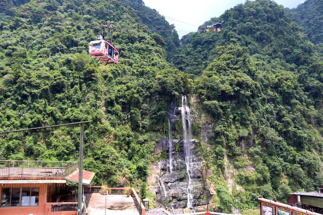
Wulai Waterfall is the highest waterfall in northern Taiwan. Here you can find a street with snacks and restaurants, and a gondola that leads to a second tier of the waterfall and an amusement park. In addition there are hikes, wildlife, and endless mountain scenery to explore.
Background: Wulai was originally an Atayal aborigine village, its name meaning hot and poisonous. There has always been natural hot springs in Wulai, but much of that water has been channeled into hotels and public bathhouses. The free hot springs stood at the bottom of the hill next to the river, and was a collection of used hot spring water from the hotels and paid hot springs above. In its prime, it boasted the largest free outdoor hot springs in Taiwan. Recently the District of Wulai in New Taipei has become a major tourist attraction, partly because of its close proximity to Taipei. It has museums, waterfalls, a gondola, a train, an old street night market, and most of all hot springs. The main delicacies on the old street are Taiwan ingenuous foods such as wild boar meat and rice steamed in bamboo. Wulai waterfall is 80 meters high, making it the highest waterfall in northern Taiwan. It's highest point sits at 230 meters above sea level, and drops to 150 meters above sea level. The waterfall is also about 10 meters wide. Yunceng Amusement Park began construction in 1960 and was completed in 1970. It includes a gondola, hotel, swimming pool, canoe pond, and other activities. Originally it had a roller coaster, pirate ship, and other rides, but these have all been taken down. Hours: Waterfall: 24/7 Cable Car and Yun Hsien Amusement Park Entrance: 9 AM to 4:30 PM You can book tickets to the gondola and to Yun Hsien theme park on Klook here or KKday here. Neidong Waterfall: 8 AM to 5 PM. You can book tickets to Neidong Forest Recreation Area on KKday here or Klook here. Price: Wulai Waterfall: Free Cable Car and Yun Hsien Amusement Park Entrance: 220 NT per person You can book tickets to the gondola and to Yun Hsien theme park on Klook here or KKday here. Neidong Waterfall: 65 NT per person. You can book tickets on KKday here or Klook here. Hot Spring Bath: 300-500 NT. You can look for hot spring bath experiences on Klook here or KKday here. Tours and Activities: You can book a Taiwan Wulai Aboriginal Tribe afternoon Tour on TripAdvisor here. You can also book a tour of Wulai on KKday here. You can also book a ticket on the Wulai Train on Klook here, or a river tracing experience in Wulai on Klook here, or SUP paddleboarding experience in Wulai on KKday here, hot spring baths on Klook here or KKday here, on or tickets to the gondola and to Yun Hsien theme park on Klook here or KKday here. Hotels in Wulai: There are many hot spring hotels in Wulai that have a hot spring tub right in the room. We have stayed at and recommend Wulai SungLyu Hot Spring Resort, which is a hot spring resort with great views just above Wulai Old Street. You can book on Booking.com here, Agoda here, Hotels.com here, TripAdvisor here, Trip.com here, Klook here, Kayak here, or Expedia here. Looking for a hotel? We recommend booking through Booking.com here, which provides the best quality selection of accommodation in Taiwan. Find out where to stay in our Taiwan hotels guide or search for the best hotel deals in Taiwan here. How to get there: By Bus: From central Taipei, take bus 849 to Wulai Waterfall. The trips takes about an hour and a half. You can purchase a discount easy card to use on a bus to Wulai on Klook here or KKday here. You can also book a Taipei travel pass on Klook here. By Car: From Taipei, take provincial highway 9甲 to Wulai. There is a large paid parking garage in front of the old street. You may also be able to find free parking further up the road closer to the waterfall but car parking is very limited. If you are looking for car rentals, you can also search Qeeq here, Klook here, or KKday here. You can also check out our car rental guide here. Looking for scooter rental in Taipei? You can search on Klook here or KKday here to search for options. You can also check out our scooter rental guide here. By Taxi: You can take short rides for about 150 NT, or hire a Taxi for a day for around 150 USD on Klook here. By Bicycle: Cycling is the best way to enjoy Taiwan's landscapes if you have the time and energy. Looking for bicycle rentals in Taiwan? You can use Taiwan's many Youbike sharing stations, or search for rentals on KKday here, and search for tours on Klook here. You can also check out our Taiwan cycling guide here. You can also book a Sunset Riverside Bike Ride and Historical Tour, 4 Hour Cycling in Taipei, Ultimate 8-Hour Cycling City Tour, or Taipei City Bike Tour with Night Market Experience on TripAdvisor here. For more information, check out our Taiwan transportation guide here. Map: Please see below of the places covered in this blog: 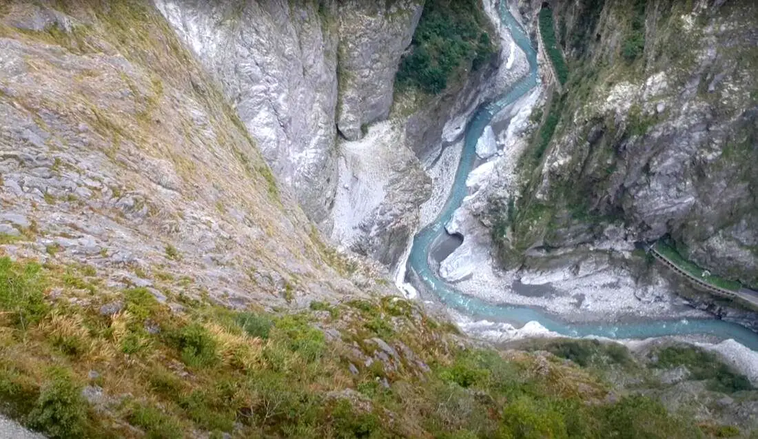
If you only have a few days in Taiwan and you want to go somewhere outside of Taipei, you should definitely go to Taroko National Park. On an island full of mountains, rain forests, beaches, and abounding natural beauty, Taroko might just take the top spot as the most beautiful scenic area in Taiwan.
Taroko National Park is well known for its amazing marble cliffs and canyons carved out by the Liwu River. It is also a popular spot for hiking, rafting, and river tracing. If you have the time, come to the East coast and see it. If you don't have time, then make some time! History and Background: Taroko National Park is well known for its marble cliffs and canyons, and is also known as "The Marble Gorge." Millions of years ago, the rock we see today was sediment at the bottom of the Pacific Ocean, but oceanic and tectonic pressure turned it into limestone, and later into marble. Later the Eurasian plate was uplifted where Taiwan is today, and a gorge was cut out of the limestone thanks to the Liwu River. Taroko means "human being," from the Truku tribal language. Originally the Tupido Tribe settled in the area of what is now Tianxiang Taiti mesa. They built the Tupido Tribe Trail which was only 30 cm wide, and resided there until they were massacred by the Japanese in 1914. In 1917, the Japanese expanded the original trail made by the Tupido Tribe to 1.5 M and forced aboriginal tribesmen to carry goods along the trail to the east coast. This is now the Zhuilu Old Trail. Currently only 3km of the trail is open to the public. The Japanese created a national park in the Area in 1937, which was disestablished by the ROC in 1945, and then reenstated in as a national park in 1986. When to visit? Hualien is great year round, but it can get a little hot in the summer, and Typhoon season and heavy rain season lasts from about May to October. If you are afraid of the heat and rain then you can visit during winter when the temperatures are mild and the climate is usually dryer. Sponsored Links Where to stay? Most of the accommodation you will find is near the city center. If you only want to visit Hualien City and Taroko Gorge, you can consider booking a hotel near downtown, walking or cycling around the city, and taking a bus to Taroko Gorge. We have stayed at and recommend Dream Taiwan Homestay (Agoda / Booking.com / Expedia / Hotels.com), a high quality hostel for the money in downtown Hualien, Farglory Hotel (Agoda / Booking.com / Expedia / Hotels.com), right next to Farglory Ocean Park with amazing views of Hualien, and Goldenflower B&B (Agoda / Booking.com) in Yuli right next to Sixty Stone Mountain. You can find out where to stay in our Taiwan hotels guide or search for the best hotel deals in Taiwan here. How to get there: By Car: From Taipei, Take National Highway 5 to Yilan and then drive on the Suhua Highway 9 to Hualien. A few miles before Hualien City, the gorge will be on your right. By Train: Take the train to Hualien station, and from there you can rent a scooter or car, or take a tour bus to the gorge. For more travel information see here. You can book tickets to travel to Hualien via inter-city bus on Klook here. Book tickets via the normal train (TRA) on Klook here. Need travel insurance? Compare prices on Insubuy here. How to get around in Taroko Gorge: As always, we recommend renting a scooter as the best way to see Taiwan. However, you can also a great deal of Tainan by taking the train, inter-city bus, local bus, biking, or just walking. Getting around in a car is also a convenient option as there is plenty of parking pretty much everywhere in this less crowded county. By Bus: You can book a shuttle bus to Taroko Gorge from Hualien on Klook here. Scooter Rental: Looking for scooter rental in Hualien? You can search KKday here or Klook here to look for options. You can also check out our scooter rental guide here. Car Rental: If you are looking for car rentals in Hualien, you can also search Klook here or KKDay here. You can also check out our car rental guide here. Tours: You can find more tours and activities in Hualien such as Surfing, Paragliding, SUP / Paddle Boarding, Kayaking, Canoeing, River Tracing, River Rafting, Whale Watching, Snorkeling, Diving, ATV / 4-wheeling, Paintballing, Farm Dream Estates Zoo, Water Biking, Oyster Harvesting, Shrimp Harvesting, Indigenous Experience, Glamping, Cycling, Ziplining and much more on Klook here or KKday here. You can also book Wifi and SIM cards for Taiwan on Gigago here. Just to let you know, if you book using the links above, we get some commission at no cost to you, and you can help support our blog. You can click here to receive $5 USD on your first Klook purchase. Hours: 8:30AM-5PM (Zhuilu old trail is open from 7AM to 10PM). Flying a Drone? Apply for a drone permit here. Price: Free! (Except Zhuilu old trail, which is 200 NT per adult. See below for more info.) Map: Please see below: 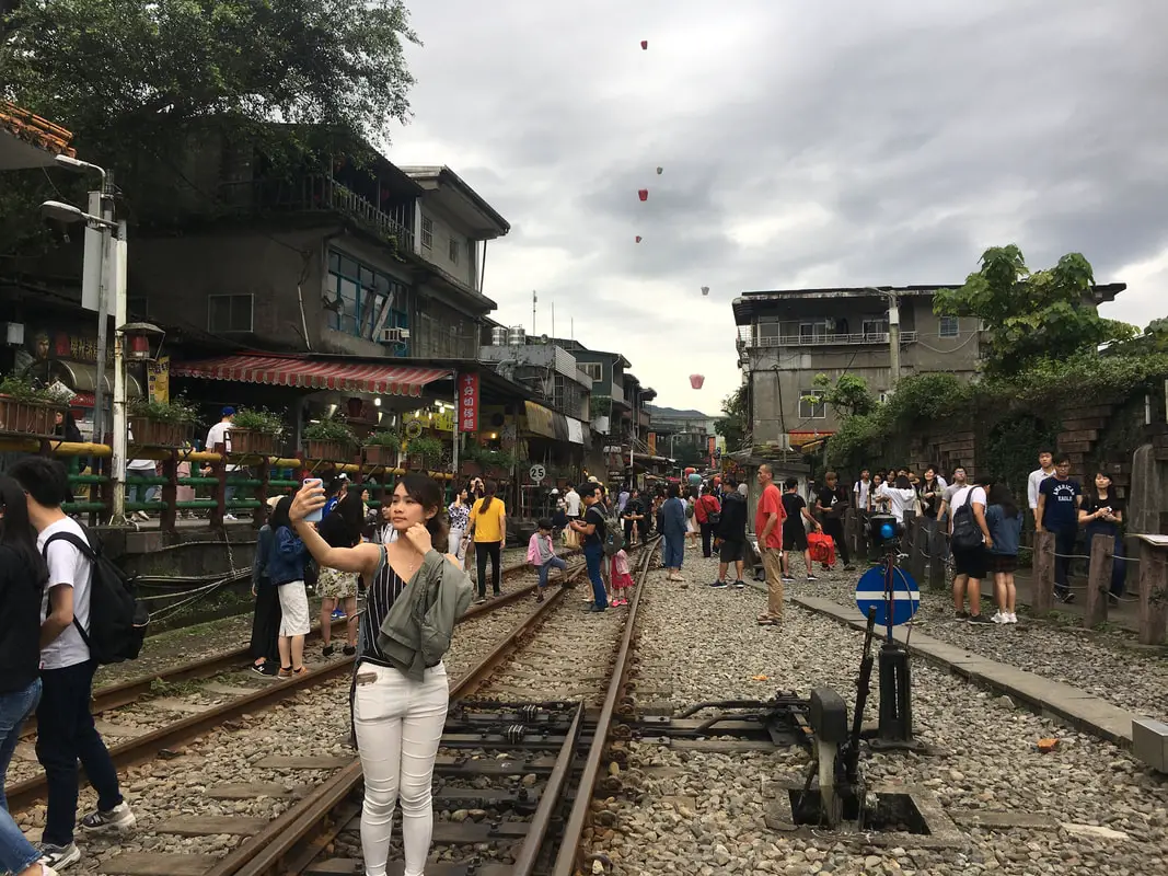
Shifen Old Street is the largest and busiest old street on the Pingxi Railway line, famous for setting off lanterns into the sky, and for visiting the famous Shifen Waterfall nearby. Here one can enjoy delicious food, beautiful scenery, and learn about the mining history of the area. The sky lanterns have become a major environmental issue, but because of the allure to tourists the practice doesn't seem like it will end soon.
Background: The town of Shifen, which was originally named for the ten families that lived there in the Qing Dynasty, who needed ten portions of goods (Shi 十 = ten Fen 分/份 = portion). Shifen Train station was completed in1918 and is the biggest train station on the Pingxi Railway line. During its heyday, it had the largest coal mining operation and largest population in Pingxi District of New Taipei. After the coal industry died down in the 1970s, tourism has taken its place as the major industry in the area. The practice of lighting off sky lanterns in Taiwan began in Shifen, when during the Qing Dynasty local villagers would flee into the mountains during raids from bandits. Once the bandits had left, the remaining villagers sent sky lanterns into the air to let the fleeing villagers know that it was safe to come down from the mountains. The people of Shifen send off sky lanterns as a symbol of peace, and celebrate every year during Lantern Festival (元宵節), a Chinese holiday. Setting off sky lanterns as a tourist attraction began in the 1990's and you can find people lighting off lanterns every day from Shifen. Because of the hundreds of sky lanterns set off every day, this creates an environmental problem with lantern trash piling around the forests and mountains of Pingxi District. The local people and volunteers help to clean up, but because of the tourism allure associated with lighting off the sky lanterns, it seems that this practice is not going away anytime soon. Hours: Winter ( October to May): 9 AM -4:30 PM (last people admitted, park open till 5:00 PM) Summer (June to September) 9 AM -5:30 PM (last people admitted, park open till 6:00 PM) Price: Free When to go: Lantern Festival! (February to March) If you go during weekends or holidays, it can get really crowded on the Pingxi Railway, especially if you plan on taking the train. You may not be able to even fit on the train, so go on weekdays to avoid the crowds. Tours: You can book a tour to Shifen on TripAdvisor here, Klook here, or KKday here. Activities Around Pingxi: Don't forget that there are many activities available around Pingxi such as Rock Climbing, Hiking, kayaking, canoeing, snorkeling, SUP / paddle boarding, water biking, Diving, River Tracing / Canyoneering, ATVing, Horse Riding, Cooking Class, photo shoot, Jingtong Sky Lantern Police Station, Shifen Sky Lantern Experience, Waterfall Zipline, Waterfall Diving, and more on Tripadvisor here, Klook here, or KKday here. Hotels Near Shifen: We recommend Fullon Hotel which has locations in Tamsui and Fulong near the beach (book on Booking.com here, Tripadvisor here, Agoda here, or Hotels.com here). We have stayed at and recommend Gold Mountain Ranch, which is a horse ranch and glamping destination in Jinshan. You can book a night at Gold Mountain Ranch on Klook here. You can also check out our full blog on the ranch here. We have also stayed at and recommend Hai Xia Your Home which is right in front of Fulong Beach (book on Booking.com here, Tripadvisor here, Agoda here, or Hotels.com here). Looking for a hotel? We recommend booking through Booking.com here, which provides the best quality selection of accommodation in Taiwan. Find out where to stay in our Taiwan hotels guide or search for the best hotel deals in Taiwan here. How to get there: By Train: Take the TRA to Ruifang Station, and then switch to the Pingxi Railway line. Get off at Shifen Station, and you have arrived at Shifen Old Street! Book tickets via the normal train (TRA) on Klook here. You can book tickets to the high speed rail (HSR) on Klook here or KKDay here. You can also book tickets to travel to Shifen via inter-city bus on Klook here. By Car/Scooter: Take provincial highway 2 east toward Pinglin, then get off the main highway once you reach Shifen. The Old Street is to the right of the main bridge across the valley. Parking is plentiful but you may have to walk a ways to get to the old street. If you are looking for car rentals, you can also search Qeeq here, Klook here, or KKday here. You can also check out our car rental guide here. Looking for scooter rental in Taipei? You can search on Klook here or KKday here to search for options. You can also check out our scooter rental guide here. By Taxi: You can take short rides for about 150 NT, or hire a Taxi for a day for around 150 USD on Klook here. By Bus: You can also book tickets to travel to Pingxi via inter-city bus on Klook here. You can also book a Taipei Sightseeing: Hop On, Hop Off Open Top Bus on TripAdvisor here. By Bicycle: Cycling is the best way to enjoy Taiwan's landscapes if you have the time and energy. Looking for bicycle rentals in Taiwan? You can use Taiwan's many Youbike sharing stations, or search for rentals on KKday here, and search for tours on Klook here. You can also check out our Taiwan cycling guide here. You can also book a Sunset Riverside Bike Ride and Historical Tour, 4 Hour Cycling in Taipei, Ultimate 8-Hour Cycling City Tour, or Taipei City Bike Tour with Night Market Experience on TripAdvisor here. For more information, check out our Taiwan transportation guide here. Map: Please see below: 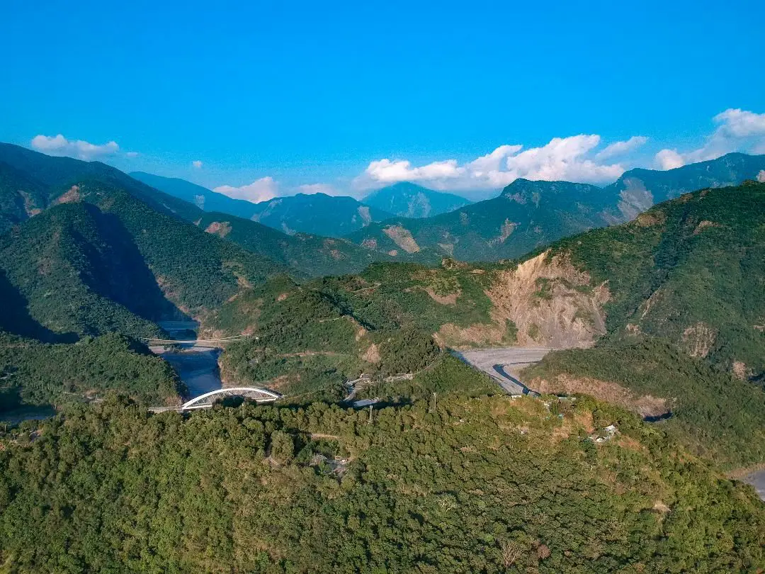
Maolin District of Kaohsiung City is an amazing outdoor paradise and my favorite place in Taiwan. In this mountainous district of Kaohsiung, you can find waterfalls, streams, hot springs, butterflies, aboriginal culture, and great views, all by the roadside! Popular activities include swimming, hot spring bathing, river tracing, camping, and hiking.
Please note I have also finished blogs about Maolin Village, Wanshan Village, Duona Suspension Bridge, and Duona Village (click the links to see each individual blog). Background: During the Japanese occupation, some of the original inhabitants of Maolin Village live in the mountains behind Wanshan Village. However later these aboriginals were forcibly moved to the current village. Many of the inhabitants were originally located elsewhere, but had to relocate their home or village due to typhoons or unsafe terrain. There are a few abandoned villages above the current village that you can still hike to. The villages have about 2000 total inhabitants, mostly aboriginals from the Rukai (魯凱族) Wulu Bunun (布農) and Paiwan (排灣) tribes, as well as some Han Chinese people. The district also has Maolin Middle school, the only middle school, and three elementary schools. Wanshan has the smallest population of any village in Taiwan according to the government website here, with a population of just 450 people. 95% of the people are aborigines from the Rukai Tribe (魯凱族), and the rest are either from the Wulu Bunun Tribe (布農) or Han Chinese. Originally the people of Wanshan village lived at the base of Mali Mountain (麻里山), but were moved by the government in 1956 to their current location. Many of the inhabitants of Maolin were originally located elsewhere, but had to relocate their home or village due to typhoons or unsafe terrain. There are a few abandoned villages around Maolin that you can still hike to. Typhoon Morakot brought record floods to Taiwan because it slowly moved over the island delivering torrential rain. Nearly 700 people were killed during the disaster (to see what Maolin looked like right after the flooding, check out this blog here). Basically all the bridges in Maolin were destroyed during Typhoon Morakot in 2009 except Duona Suspension bridge which is built so high that it would never be affected by floodwater. Most all the bridges currently in Maolin were reconstructed after the 2009 floods. Duona is the most remote village in Maolin District of Kaohsiung City, and is said to harbor the most complete version of the Rukai Aborigine culture. The Rukai People first began to move into the area now known as Duona about 300 years ago (1700s), making it one of the oldest aborigine villages in Taiwan. Most of the people live in traditional stone houses made from nearby plentiful shale rock, which are characteristic of the Rukai Tribe. The stone houses are warm in the winter and stay cool during the summer. Near the village is a small plain which is said to be the home of Taiwan's indigenous species of black rice. The village was almost completely cut off from the outside world until the Japanese built the Duona Suspension Bridge, which helped to link it to the rest of Taiwan as well as better control the native population. The actual Distrcit boundaries extend to Pingtung County and Taitung County, and include largely untouched and "virgin" forests and mountain wilderness areas such as Shuang-guei Lake, providing precious wildlife habitat for many of Taiwan's indigenous animals and plants. Price: Free Hours: 24/7 When to go: I recommend going in the summer time when the waterfalls have plenty of water and warm temperatures make it a great time to go swimming. In winter it will be cold and the waterfalls can dry up. On the other hand if you want to go just for hiking, winter would be a better time to go. If there is a Typhoon, the inhabitants of Maolin will be evacuated, and you should not try to go in for your own safety. If you are coming to see butterflies, the butterfly migration is in the fall and ends roughly in November. How to get there: By Car: Maolin can be reached via provincial highway 27 from Pingtung or Liugui. Once you come to Dajin Bridge, go straight up the mountain. Looking for scooter rental in Kaohsiung? You can check out Klook here or KKday here to search for options. You can check also out our scooter rental guide here. If you are looking for car rentals, you can search Qeeq here, KKday here, or Klook here. You can also check out our car rental guide here. By Bus: You can take a bus there but I don't recommend it. It's a 3 hour bus ride from Pingtung Bus Station. If you can rent a car or scooter it is about a 1 1/2 hour drive from Kaohsiung. You can book tickets to travel to Kaohsiung via inter-city bus on Klook here. You can book tickets to Kaohsiung via high speed rail (HSR) on Klook here or KKDay here. Book tickets via the normal train (TRA) on Klook here. You can also book a Kaohsiung Travel pass here. Accommodation We have stayed at and recommend Chao She Hotel (you can book on Agoda here, Booking.com here, Hotels.com here, or Expedia here) IHI Sanduo Travel Hotel (you can book on Agoda here, Booking.com here, Hotels.com here, or Expedia here), and Mingli Hotel (you can book on Agoda here, Klook here, or Hotels.com here) which are three inexpensive and high quality choices in downtown Kaohsiung. I also have stayed at and recommend Kaohsiung Meinong Rabbit Paul Homestay B&B (you can book on Agoda here, Booking.com here, or Trip.com here), a quiet B&B in rural Meinong, and Chengching Lakeside Resort (you can book on Agoda here, Booking.com or Trip.com here)and the Grand Hotel Kaohsiung (you can book on Agoda here, Booking.com here, Hotels.com here, or Expedia here) which both offer breakfast buffet and free entrance into Chenqing Lake Park. I have also stayed at the 85 sky tower which offers great views of the city; you can search for rooms in the 85 sky tower on Agoda here, Booking.com here, Hotels.com here, Expedia here, or Trip.com here). Find out more about where to stay in our Taiwan hotels guide or search for the best hotel deals in Taiwan here. We recommend booking through Agoda here, which provides the best quality selection of accommodation on the islands. You can also book Wifi and SIM cards for Taiwan on Gigago here. Need travel insurance? Compare prices on Insubuy here. Tours: You can find more tours and activities in Kaohsiung such as Pier 2, Meinong Hakka Museum, Hamasen Railway Museum, Suzuka Circuit Park, i-Ride Kaohsiung Visual 5D Flying Theater, National Science and Technology Museum , Senya Village Restaruant, Austin Land, Ski School Indoor Ski Slope, and many more on Klook here or KKday here. Just to let you know, if you book using the links above, we get some commission at no cost to you, and you can help support our blog. You can click here to receive $5 USD on your first Klook purchase. Map: Please see a map below marked with all the destinations we will visit in this blog: 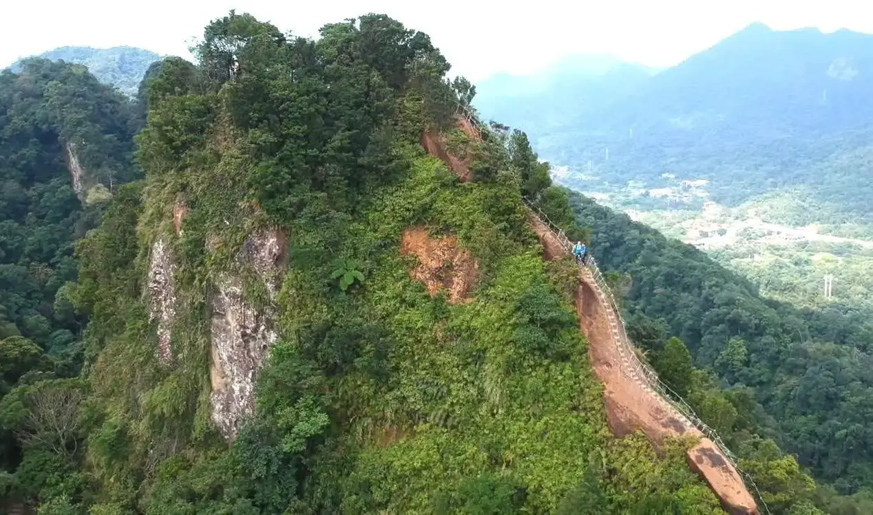
Taipei is full of very accessible hikes right next to the city center. You can find amazing views of Taipei City, as well as make some adrenaline pumping hikes up some very steep peaks in New Taipei and Keelung. We highly recommend checking out what hikes Taipei has to offer. In this guide, we will list out some of the most amazing hikes around Taipei.
Safety Tips When Hiking in Taipei:
Basic Taipei Travel Tips:
When should you go to Taipei? In my opinion, the best weather in Taipei is from March-May, and October - November, when the temperatures stay around 26 degrees Celsius and there is not as much rain. Summers are also nice, with the most sunny weather, but also hot and rainy. Winters can be cold (but not below freezing) and usually wet. Overall, there is no wrong answer as to what time of year you should visit Taipei. You will have a great time here at any time of year. Hotels in Taipei: High end: We have stayed at and recommend the Yuanshan Grand Hotel, once the tallest building in Taiwan and still the most grand (book on Booking.com here, Tripadvisor here, or Agoda here). We have also stayed at and recommend the Grand Hyatt (book on Booking.com here, Tripadvisor here, Agoda here, or Hotels.com here), Marriot (book on Booking.com here, Tripadvisor here, Agoda here, or Hotels.com here), Sheraton (book on Booking.com here, Tripadvisor here, Agoda here, or Hotels.com here), Shangri-la (book on Booking.com here, Tripadvisor here, Agoda here, or Hotels.com here), and Regent (book on Booking.com here, Tripadvisor here, Agoda here, or Hotels.com here), which are all very high quality hotels in the middle of Taipei City. We also recommend Fullon Hotel which has locations in Tamsui and Fulong near the beach (book on Booking.com here, Tripadvisor here, Agoda here, or Hotels.com here). Budget Hotels: We have stayed at and recommend and also Fu Chang Hotel in Ximending, which is within walking distance of Ximending shopping district (book on Booking.com here, Tripadvisor here, or Agoda here). We have also stayed at and recommend Hai Xia Your Home which is right in front of Fulong Beach (book on Booking.com here, Tripadvisor here, Agoda here, or Hotels.com here). Looking for a hotel? We recommend booking through Booking.com here, which provides the best quality selection of accommodation in Taiwan. Find out where to stay in our Taiwan hotels guide or search for the best hotel deals in Taiwan here. Tours in Taipei: There are many tour itineraries that you can enjoy in Taipei that will take you to multiple destinations and arrange transportation. For more information, you can check out Tripadvisor here, KKday here or Klook here, which are both great tour websites that can connect you with the right tour and tour guide for you. Here are some of the post popular tours of Taipei on Tripadvisor:
Attractions in Taipei: There are many attractions that you can enjoy in Taipei such as Taipei 101 Observatory, Taipei 101 460 Skyline Observatory, Taipei Children's Amusement Park, Maokong Gondola, National Palace Museum, Yehliu Ocean World, Yehliu Geopark, National Museum of Marine Science and Biology, i-ride 5D cinema, Astronomical Museum, Miniatures Museum of Taiwan, Double Decker Sightseeing Bus, Miramar Ferris Wheel Ticket, Taipei Zoo, Heping Island Park, Ju Ming Museum, Yuanshan Hotel Secret Road, National Taiwan Museum, New Taipei Gold Museum, Futian Leisure Farm, Chiang Kai-shek Shilin Residence, Chi Po-lin Museaum, Beitou Museum, Tsao Wonderland, Railway Museum, Fort San Domingo, 13 Levels Archaeology Museum, Austin Land, Museum of World Religions, Formosan Aboriginies Museum, ASE Parent-child Park, teamLab Future Park, Yukids Island, VR Experience, Bat Cave, Neidong Waterfall, Candlestick Islet, Jurassic Snow Park, Zhonghe High5 Amusement Park, Longshan Temple, Xingtian Temple, Ningxia Night Market, Yansan Night Market, Meteor Garden, Yingge Old Street, and many more attractions on Tripadvisor here, Klook here, or KKday here. Activities in Taipei: Indoor Skiing, Rock Climbing, Hiking, Wakeboarding, Surfing, Speedboat Surfing, SUP / Paddle Boarding, Diving, Snorkeling Kayaking, Canoeing, Water Biking, River Tracing / Canyoneering, ATVing, Horse Riding, Cooking Class, Archery, Ice Skating, Roller Skating, Tree Climbing, Urban Camping, Glamping, Motorcycling, Motorbike Tour, Dragon Boat Racing, Escape Room, Shen'ao Rail Bike, Laser Gun Experience, Batting Cages, Bowling, Paintball, Flight Simulation Experience, Taipei Tram Driving Experience, Rail Simulation Experience, Taipei 101 Observation Deck activity, Strawberry Picking, Professional Photo Shoot, Body Relaxation SPA, Night Tour, Calligraphy Workshop rand more on Tripadvisor here, Klook here, or KKday here. Just to let you know, if you book using the links above, we get some commission at no cost to you, and you can help support our blog. Some of the Klook links may not work if you are using an Ad blocker. You can click here to receive $5 USD on your first Klook purchase. How to get there: The only way to get to Taiwan is via airplane. Planes leave daily from Taipei's Songshan and Toayuan Airport. Taoyuan Airport: Taoyuan is Taiwan's largest airport and typically has cheaper flights and more flight times to choose from. It's about an hour's journey from Taoyuan Airport to the center of Taipei. You can travel via MRT, HSR, bus, or taxi to get to Taipei. You can get 30% off the Taoyuan Airport VIP lounge on KKday here. Songshan Airport: Songshan is a small airport in Taipei's city center, and can be a convenient option for people traveling within Asia. The airport is right on the Taipei MRT brown line. You can book cheap flights to Taiwan on KKday here, Trip.com here, CheapO Air here, or Kiwi here. How to get around in Taipei: Taipei's transportation system is convenient and safe. There are many options you can consider to get around in Taipei below: By Train: Gets you to the city center of all major cities in Taiwan. It is about 800NT to get from Taipei to Kaohsiung. Roughly half the price of the HSR. Book tickets via the normal train (TRA) on Klook here. By HSR: (High-Speed Rail) – Gets you quickly from north to south. Besides Taipei and Kaohsiung, most of the stations are far from city centers. It costs about 1500NT to get from Taipei to Kaohsiung. You can book tickets to the high-speed rail (HSR) on Klook here or KKDay here. By MRT: (Mass Rapid Transit, Metro train, subway) – Easily gets you around Taipei and Kaohsiung. You can also book an MRT travel pass on Klook here. By Bus: Buses can be tricky. Long-range buses such as Ubus and King Bus are easier to understand and cheaper than the local train. They can take you to the city center of every city throughout Taiwan and to remote tourist destinations such as sun moon lake. A long-range bus from Taipei to Kaohsiung is about 500 NT. You can also book tickets to travel to Shifen via inter-city bus on Klook here. You can also book a Taipei Sightseeing: Hop On, Hop Off Open Top Bus on TripAdvisor here. By Taxi: You can take short rides for about 150 NT, or hire a Taxi for a day for around 150 USD. By Car: If you are looking for car rentals, you can also search Qeeq here, Klook here, or KKday here. You can also check out our car rental guide here. By Scooter: Looking for scooter rental in Taipei? Click here or here to search for options. You can also check out our scooter rental guide here. By Bicycle: Cycling is the best way to enjoy Taiwan's landscapes if you have the time and energy. Looking for bicycle rentals in Taiwan? You can use Taiwan's many Youbike bike sharing stations, or search for rentals on KKday here, and search for tours on Klook here. You can also check out our Taiwan cycling guide here. You can also book a Sunset Riverside Bike Ride and Historical Tour, 4 Hour Cycling in Taipei, Ultimate 8-Hour Cycling City Tour, or Taipei City Bike Tour with Night Market Experience on TripAdvisor here. For more information, check out our Taiwan transportation guide here. Tourist Site Map: Check out our map below of tourist sites in Taiwan, which is constantly updated: 
Yes, you should go to Kenting. Kenting has some of the best natural scenery in Taiwan, from beautiful white sand beaches that are warm year round to limestone mountains with hundreds of caves and waterfalls to explore. Although it may not be a world class beach resort destination yet, it should definitely be on your list on your trip to Taiwan.
Historical Background: The area around the Hengchun Peninsula was once coral that has been uplifted over millions of years. The first people to live here were Taiwan aboriginals, from the Paiwan and Puyuma tribes (who caused the Rover Incident as portrayed in Seqalu: Formosa 1867). Kenting was first settled by Han farmers and fishermen during the Qing Dynasty. The word Kenting comes from two words that mean cultivate (ken3 墾) and strong man (丁 ding1). During that time, a group of strong men (or Zhuang Ding 壯丁) came from Guangdong, who were basically Chinese pioneers of the area to cultivate the land, hence the area was named Kenting for them. The aboriginal people were mostly assimilated with the local Chinese population. The area was considered to be made into a park during the Japanese occupation due to it being the only tropical location in the Japanese Empire, but was never officially created. During the Japanese era, Nanwan was used as a whaling area and there were a few fishing villages here. The Whaling industry continued here in the ROC era until the international ban on whaling in 1986. Kenting National Park was established in 1984 as the first national park in Taiwan after WWII. Kenting became a major vacation spot, becoming a center for hostels and hotels for travelers. Kenting is considered by many to have the best beaches in Taiwan. This is because of its fine white sand and year-round warm temperatures and sunshine (it is in the tropical part of Taiwan after all). When to go: Summer is the best time to go because there is warm sunny weather and not a lot of wind. However, there are more people and there may be Typhoons. Winters are windy and colder, but the water is still warm enough to swim in. Winter is a better time for activities like hiking and surfing. How to get there: By Car/Scooter: Take provincial highway 1 south to the bottom of Taiwan until it becomes provincial highway 26. After that keep going past Hengchun into Kenting National Park. Looking for scooter rental in Kenting? Click here or here to search for options. If you are looking for car rentals, you can also search Qeeq here, Klook here, or KKday here. You can also check out our car rental guide here. By Bus: Busses leave daily to Kenting from Zuoying HSR station, Kaohsiung Station, and Pingtung. You can book tickets to Kenting via high speed rail (HSR) on Klook here or KKDay here, or book tickets via the normal train (TRA) on Klook here. You can book tickets to travel to Kenting via inter-city bus on Klook here. Once in Kenting, you can save money by booking Kenting's bus pass. By Plane: There are direct shuttle busses to Kenting from Kaohsing's Xiaogang (KHH) Airport. You can search for cheap flights in Taiwan here. By Bicycle: Cycling is the best way to enjoy Taiwan's landscapes if you have the time and energy. Looking for bicycle rentals in Taiwan? You can search on KKday here and search for tours on Klook here. You can also check out our Taiwan cycling guide here. Where to stay: Looking for a hotel? Find out where to stay in our Taiwan hotels guide or search for the best hotel deals in Taiwan here. We recommend booking through Agoda here, which provides the best quality selection of accommodation in Taiwan. I have stayed at many hostels and hotels in Pingtung, and even almost bought a house here. Some places that I have stayed at and can recommend are Nanwan Kiki (book on Agoda here or Booking.com here), a B&B next to Nanwan Bay, Kenting's most popular Beach. There are also a few decent hotels near Kenting Street Night Market like Kenting Star Inn 888 (book on Agoda here, Klook here, or Booking.com here), or Kenting Dajianshan Hotel (book on Agoda here or Booking.com here). You will notice that none of these hotels are five star resorts (I do not come to Kenting to waste my time at a resort, but you can still search Agoda, Booking.com, or Klook here for those) but they are in my opinion the above have the best value for the money. How to get around in Kenting: 1. Rent a scooter - the best way to see Taiwan. Electric scooters that do not require a license are also readily available. For better range and speed, rent a gas scooter. You can search for scooter options here or here, and you can check out our scooter rental guide here. 2. Rent a car - more expensive than a scooter but may be more suitable for a large family. If you are looking for car rentals, you can also search Qeeq here, Klook here, or KKday here. You can also check out our car rental guide here. 3. Take the Kenting bus - cheap but slower than your own transportation, and it doesn't stop everywhere. You can book tickets to travel to Kenting via inter-city bus on Klook here. 4. Cycle - you can rent a bicycle or bring your own. This is a great way to enjoy the scenery at a slower pace. You can search on KKday here and search for tours on Klook here. You can also check out our Taiwan cycling guide here. 5. Hire a taxi - more expensive than a rental car but perhaps more convenient. You can also search for a car charter service here or here. Tours and Activities in Kenting: There are many activities available in Kenting, such as snorkeling, diving, SUPing, surfing, submarine riding, and river tracing. You can find more tours of Kenting on Klook here or KKday here. Just to let you know, if you book using the links above, we get some commission at no cost to you, and you can help support our blog. You can click here to receive $5 USD on your first Klook purchase. Places we will cover in this blog:
Map of sites in this blog: 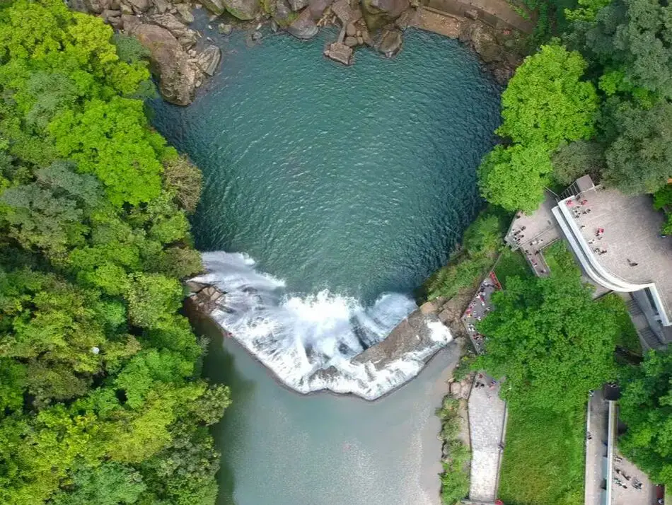
Taipei is home to some of Taiwan's most magnificent waterfalls, and most of them are just a short trip away. Here we have compiled a list of the most easily accessible waterfalls around Taipei.
Please note this is not an exhaustive list. There are many more waterfalls in Taipei than are listed in this blog. Get out there and discover Taipei's waterfalls for yourself! Safety Tips When Visiting Waterfalls:
Basic Taipei Travel Tips:
When should you go to Taipei? In my opinion, the best weather in Taipei is from March-May, and October - November, when the temperatures stay around 26 degrees Celsius and there is not as much rain. Summers are also nice, with the most sunny weather, but also hot and rainy. Winters can be cold (but not below freezing) and usually wet. Overall, there is no wrong answer as to what time of year you should visit Taipei. You will have a great time here at any time of year. Hotels in Taipei: We have stayed at and recommend the Yuanshan Grand Hotel, once the tallest building in Taiwan and still the most grand (book on Booking.com here, Agoda here, or Kayak here). We also recommend Fullon Hotel which has locations in Tamsui and Fulong near the beach (book on Booking.com here, Agoda here, or Kayak here). Budget Hotels: We have stayed at and also recommend Fu Chang Hotel in Ximending, which is within walking distance of Ximending shopping district (book on Booking.com here, Agoda here, or Kayak here). We have also stayed at and recommend Hai Xia Your Home which is right in front of Fulong Beach (book on Booking.com here, Agoda here, or Kayak here). Looking for a hotel? We recommend booking through Booking.com here, which provides the best quality selection of accommodation in Taiwan. Find out where to stay in our Taiwan hotels guide or search for the best hotel deals in Taiwan here. Tours in Taipei: There are many tour itineraries that you can enjoy in Taipei that will take you to multiple destinations and arrange transportation. For more information, you can check out KKday here or Klook here. Attractions in Taipei: There are many attractions that you can enjoy in Taipei such as Taipei 101 Observatory, Taipei 101 460 Skyline Observatory, Taipei Children's Amusement Park, Maokong Gondola, National Palace Museum and many more attractions on Klook here or KKday here. Activities in Taipei: You can also look for more activities in Taipei such as Rock Climbing, Surfing, Speedboat Surfing, Diving, Snorkeling, Cooking Class, Glamping, Motorcycling, and more on Klook here or KKday here. Just to let you know, if you book using the links above, we get some commission at no cost to you, and you can help support our blog. Some of the Klook links may not work if you are using an Ad blocker. You can click here to receive $5 USD on your first Klook purchase. How to get there: The only way to get to Taiwan is via airplane. Planes leave daily from Taipei's Songshan and Toayuan Airport. Taoyuan Airport: Taoyuan is Taiwan's largest airport and typically has cheaper flights and more flight times to choose from. It's about an hour's journey from Taoyuan Airport to the center of Taipei. You can travel via MRT, HSR, bus, or taxi to get to Taipei. You can get 30% off the Taoyuan Airport VIP lounge on KKday here. Songshan Airport: Songshan is a small airport in Taipei's city center, and can be a convenient option for people traveling within Asia. The airport is right on the Taipei MRT brown line. You can book cheap flights to Taiwan on KKday here, Trip.com here, CheapO Air here, or Kiwi here. How to get around in Taipei: Taipei's transportation system is convenient and safe. There are many options you can consider to get around in Taipei below: By Train: Gets you to the city center of all major cities in Taiwan. It is about 800NT to get from Taipei to Kaohsiung. Roughly half the price of the HSR. Book tickets via the normal train (TRA) on Klook here. By HSR: (High-Speed Rail) – Gets you quickly from north to south. Besides Taipei and Kaohsiung, most of the stations are far from city centers. It costs about 1500NT to get from Taipei to Kaohsiung. You can book tickets to the high-speed rail (HSR) on Klook here or KKDay here. By MRT: (Mass Rapid Transit, Metro train, subway) – Easily gets you around Taipei and Kaohsiung. You can also book an MRT travel pass on Klook here. By Bus: Buses can be tricky. Long-range buses such as Ubus and King Bus are easier to understand and cheaper than the local train. They can take you to the city center of every city throughout Taiwan and to remote tourist destinations such as sun moon lake. A long-range bus from Taipei to Kaohsiung is about 500 NT. You can also book tickets to travel to Shifen via inter-city bus on Klook here. By Taxi: You can take short rides for about 150 NT, or hire a Taxi for a day for around 150 USD. By Car: If you are looking for car rentals, you can also search Qeeq here, Klook here, or KKday here. You can also check out our car rental guide here. By Scooter: Looking for scooter rental in Taipei? Click here or here to search for options. You can also check out our scooter rental guide here. By Bicycle: Cycling is the best way to enjoy Taiwan's landscapes if you have the time and energy. Looking for bicycle rentals in Taiwan? You can use Taiwan's many Youbike bike sharing stations, or search for rentals on KKday here, and search for tours on Klook here. You can also check out our Taiwan cycling guide here. For more information, check out our Taiwan transportation guide here. Tourist Site Map: Check out our map below of tourist sites in Taiwan, which is constantly updated: 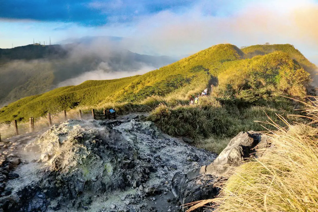
Yangmingshan National Park is a mountainous area in Taipei and New Taipei, known for its volcanic activity, hiking trails, wildlife, waterfalls, hot springs, and sulfur vents. It is definitely worth a stop on your trip to Taipei.
Historical Background: The area known as Yangmingshan now was formed by volcanoes about 700,000 years ago, forming many mountains about 1000 meters or less in northwestern Taiwan. The park still features active volcanoes, vents, and hot springs. The original name of the area was Caoshan (grass mountain 草山). During the Qing Dynasty, the area was used to harvest sulfur, and many of the hills were burned to help catch sulfur thieves, Qingtiangang likely being one of these areas. Sulfur mining was started in the Qing Dynasty by a British mining company that first obtained the rights to mine here in 1897. In 1927 during the Japanese era, Yangmingshan was made as the first national park in Taiwan, then known as Datunshan National Park Association. The area around Qingtiangang to Lengshuikeng was made into a ranch for water buffalo, and grass from Japan was planted here for them to graze. In 1950 after the ROC took Taiwan, Chiang Kai-shek renamed the park after the philosopher Wang Yangming, and called the area Yangmingshan. The KMT kept the ranch at Qingtiangang and continued to maintain it. They also built bunkers here and kept a garrison of troops. In 1985, after resolving many land disputes, Yangmingshan National Park was officially designated as a national park in the ROC era. Due to its easy accessibility from Taipei and many natural attractions, it is one of the most popular tourist destinations in Taipei City. Most visitors come on weekends, and it has parking lots and visitor's centers throughout the park. Hours: The visitor's centers are open from 9 AM to 4:30 PM. However you can visit the park 24/7. Price: Free entrance into the park (car parking 30-50 NT, scooter parking 20 NT) You can book tours to Yangmingshan on TripAdvisor here, Klook here, or KKday here or here. Tours: You can check out tours to Yangmingshan such as a One-day Yangmingshan NP Beitou Hot Spring Park and Tamsui Tour Package, Beitou and Yangmingshan Day Tour from Taipei, One Day Hike around Yangmingshan, or Private Yangmingshan Volcano Tour and more on TripAdvisor here, Klook here, or KKday here. When to Go: Silver Grass Season: Mang Grass season goes from September to November. During this time you will be able to see silvery grass all over the mountain tops around the park. Cherry Blossom Season: Cherry blossoms can be seen in the park from February to late March. Snowfall: Once every few years it can snow here from December to February. The snow usually only lasts a day or two and melts away quickly. Best Weather: In my opinion, the best weather is in the summer when constant rain makes the air cleaner, and summer mornings are usually clear. Be sure to start hiking in the morning for the best views and sunshine, as afternoon thundershowers are common. Hotels in Taipei: High end: We have stayed at and recommend the Yuanshan Grand Hotel, once the tallest building in Taiwan and still the most grand (book on Booking.com here, Tripadvisor here, or Agoda here). We have also stayed at and recommend the Grand Hyatt (book on Booking.com here, Tripadvisor here, Agoda here, or Hotels.com here), Marriot (book on Booking.com here, Tripadvisor here, Agoda here, or Hotels.com here), Sheraton (book on Booking.com here, Tripadvisor here, Agoda here, or Hotels.com here), Shangri-la (book on Booking.com here, Tripadvisor here, Agoda here, or Hotels.com here), and Regent (book on Booking.com here, Tripadvisor here, Agoda here, or Hotels.com here), which are all very high quality hotels in the middle of Taipei City. We also recommend Fullon Hotel which has locations in Tamsui and Fulong near the beach (book on Booking.com here, Tripadvisor here, Agoda here, or Hotels.com here). Budget Hotels: We have stayed at and also recommend Fu Chang Hotel in Ximending, which is within walking distance of Ximending shopping district (book on Booking.com here, Tripadvisor here, or Agoda here). We have also stayed at and recommend Hai Xia Your Home which is right in front of Fulong Beach (book on Booking.com here, Tripadvisor here, Agoda here, or Hotels.com here). Looking for a hotel? We recommend booking through Booking.com here, which provides the best quality selection of accommodation in Taiwan. Find out where to stay in our Taiwan hotels guide or search for the best hotel deals in Taiwan here. How to get there: By Car/Scooter: From Taipei, take provincial highway 2A north to the park, where you can see the main attractions such as Zhuzihu, Qixingshan, Datunshan, Qingtiangang, etc. There are many parking lots, but car parking is limited on weekends and the number of cars allowed up the mountain is also limited. There is also paid scooter parking. On weekends this place can be packed, and cars can be backed up for up to an hour or more, so consider taking a scooter or bus. Looking for scooter rental in Taipei? Check out Qeeq here, Klook here, or KKday here to search for options. You can also check out our scooter rental guide here. If you are looking for car rentals, you can also search Qeeq here, Klook here, or KKday here. You can also check out our car rental guide here. By Bus: From Beitou MRT Station, Take Little Bus 19 (小19), or another bus to the park. You can book tickets to travel to Taipei via inter-city bus on Klook here. You can book tickets to Taipei via high speed rail (HSR) on Klook here or KKDay here. By Bicycle: Cycling is the best way to enjoy Taiwan's landscapes if you have the time and energy. Looking for bicycle rentals in Taiwan? You can search on KKday here and search for tours on Klook here. You can also check out our Taiwan cycling guide here. Map: See below for a map of places mentioned in this blog: 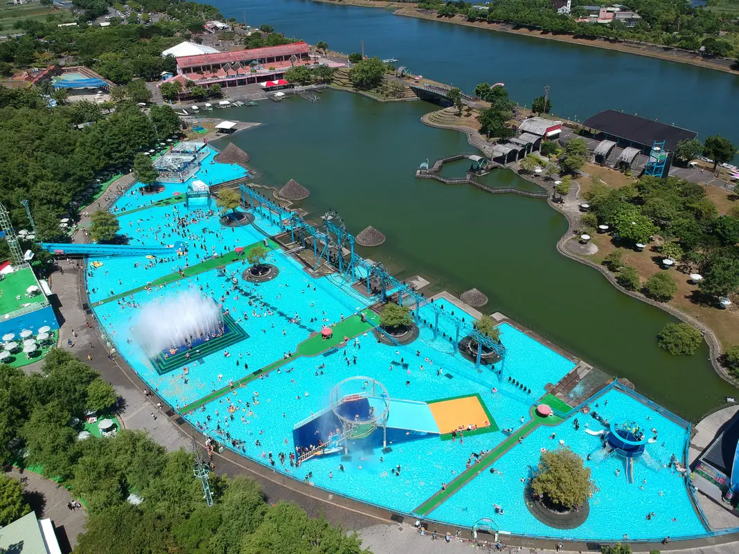
Yilan International Children's Folklore and Folkgame Festival (宜蘭國際童玩藝術節) is one of the largest children's festivals in Taiwan, occurring every year during summer break along the Dongshan River in Yilan. It features a large outdoor waterpark as well as musical performances, exhibitions, games, and cultural events. It has become a yearly tradition for many families in northern Taiwan.
Background: The festival first began in 1996 and has continued every year, except for 2008-2009 due to lack of funds, in 2003 because of SARS, and in 2020 due to COVID. The completion of the Hsueshan Tunnel in 2006 made it much easier for large amounts of people to travel quickly from Taipei to Yilan. The large event attracts many visitors from Taipei. During summer weekdays and weekends the venue can be expected to be totally packed with visitors. Hours: 10 AM to 9 PM (pool area closes at 6 PM), starting from the beginning of July to mid-August every summer. In 2024 the festival runs from July 6th to August 18th. Price: 350 NT on weekends and 250 NT on weekdays 50 NT parking fee for cars 20 NT parking fee for scooters You can book tickets for a discount on Klook here or book a day tour on KKday here. Website: https://www.yicfff.tw/index.php?lang=5tKpKqHPsMZQ82iPyZj4TQ Tours and Activities: You can purchase tours and tickets for many activities in Yilan such as Su'ao Crayon Castle, Taipingshan, Turtle Island, Lanyang Museum, Toucheng Leisure Farm, Zhang Mei Ama Capybura Farm, Bambi Land, Yinong Ranch, National Center for Traditional Arts, Taxi Museum, Glamping, Camping, ATV / 4-wheeling experience, SUP / paddle boarding, Ximeng Forest Theater, Surfing, Kayaking, Horse Riding, River Tracing, River Rafting, River Tubing, Pack Rafting, Water Biking, Snorkeling, Canoeing, Shrimping and many others through Klook here or KKday here. Accommodation: Looking for a hotel? We recommend booking through Agoda here, which provides the best quality selection of accommodation on the islands. We have stayed at and recommend Ying Shih Guest House, a resort in Datong Township near Taipingshan and Fan Fan Hot Spring (you can book on Agoda here or Booking.com here), and Jiaosi Hotspring Hotel, a hotel with hot springs in each room (you can book on Agoda here or Booking.com here). We have also stayed at Toucheng Leisure Farm, a recreational farm and experience center in Toucheng (you can book on Agoda here, Booking.com here, or on Klook here). How to get there: By car/scooter: From National Highway 5 in Yilan, take provincial highway 7 east to Dongshan River Water Park. Looking for scooter rental in Yilan? You can search Klook here or KKday here to look for options. You can also check out our scooter rental guide here. If you are looking for car rentals in Yilan, you can also search Klook here or KKDay here. You can also check out our car rental guide here. By bus: From Luodong TRA station, take bus GR21 to Dongshan River Water Park. You can book tickets to travel to Yilan via inter-city bus on Klook here. You can book tickets to Yialn via high speed rail (HSR) on Klook here or KKDay here. Book tickets via the normal train (TRA) on Klook here. Bicycle rental: Cycling is the best way to enjoy Taiwan's landscapes if you have the time and energy. Looking for bicycle rentals in Taiwan? You can search on KKday here and search for tours on Klook here. You can also check out our Taiwan cycling guide here. Map: Please see below: 
Wutan Waterfall (武潭瀑布) in Taiwu Township of Pingtung County is an easily accessible waterfall that is usually free of people. This area of mountains in southern Taiwan has almost unlimited swimmable waterfalls that are devoid of people. It is definitely a fun trip in the mountains that will not take too much time, and a great place to enjoy nature.
Background: Wutan Waterfall is about 20 meters high and features a large and deep swimming pool. It is named after Taiwu Village, which is an aboriginal village within walking distance down the hill. The holes in the rocks have been carved out of the rocks after thousands of years of erosion. There are stone steps along the side of the waterfall as well as ropes. The waterfall can get busy during holidays and weekends. Hours: 24/7 Price: Free Difficulty: Easy: 20 meters in length (one way) and 10 meters in elevation gain. The whole hike should take about two minutes from the road. Where to stay: Looking for a hotel? Find out where to stay in our Taiwan hotels guide or search for the best hotel deals in Taiwan here. We recommend booking through Agoda here, which provides the best quality selection of accommodation in Taiwan. I have stayed at many hostels and hotels in Pingtung, and even almost bought a house here. Some places that I have stayed at and can recommend are Nanwan Kiki (book on Agoda here, Booking.com here), a B&B next to Nanwan Bay, Kenting's most popular Beach. There are also a few decent hotels near Kenting Street Night Market like Kenting Star Inn 888 (book on Agoda here, Klook here, or Booking.com here), or Kenting Dajianshan Hotel (book on Agoda here or Booking.com here). You will notice that none of these hotels are five star resorts (I do not come to Kenting to waste my time at a resort, but you can still search Agoda, Booking.com, or Klook here for those) but they are in my opinion the above have the best value for the money. Tours: You can go book a river trace in Pingtung on Klook here or KKday here. How to get there: By Car/Scooter: From Pingtung, take Provincial Highway 1 souththeast until you reach Neipu and then turn southeast until you hit the 185. Drive until you reach Taiwu Village and turn up the mountain past the village to the waterfall. The waterfall is easy to find along the side of the road and there is some parking along the side of the road. Looking for scooter rental in Kenting? Click here or here to search for options. You can also check out our Taiwan scooter rental guide here. If you are looking for car rentals, you can also search Qeeq here, Klook here, or KKday here. You can also check out our car rental guide here. By Bus: You can take bus 8212 to Wutan, then it is about a 30 minute walk to the waterfall. You can book tickets to Pingtung via high speed rail (HSR) on Klook here or KKDay here, or book tickets via the normal train (TRA) on Klook here. You can book tickets to travel to Pingtung via inter-city bus on Klook here. By Bicycle: Cycling is the best way to enjoy Taiwan's landscapes if you have the time and energy. Looking for bicycle rentals in Taiwan? You can search on KKday here and search for tours on Klook here. You can also check out our Taiwan cycling guide here. Map: Please see below: 
Koushe Waterfall (口社瀑布) near Koushe Village in Gaoshu Township of Pingtung is an easily accessible, swimmable waterfall right next to the side of the road. This area of mountains in southern Taiwan has almost unlimited swimmable waterfalls that are devoid of people. It is definitely a fun trip in the mountains that will not take too much time, and a great place to enjoy nature.
Background: Koushe Waterfall is about 12 meters high and features a large swimming pool. It is named for Koushe Village, which is an aboriginal village within walking distance down the hill. The holes in the rocks have been carved out of the rocks after thousands of years of erosion, and there is a rope climb and trail along the side of the waterfalls, which can be climbed in just a few minutes. Hours: 24/7 Price: Free Difficulty: Easy: 20 meters in length (one way) and 10 meters in elevation gain. The whole hike should take about two minutes from the road. Accommodation: Looking for a hotel? Find out where to stay in our Taiwan hotels guide or search for the best hotel deals in Taiwan here. We recommend booking through Agoda here, which provides the best quality selection of accommodation in Taiwan. I have stayed at many hostels and hotels in Pingtung, and even almost bought a house here. Some places that I have stayed at and can recommend are Nanwan Kiki (book on Agoda here, Booking.com here), a B&B next to Nanwan Bay, Kenting's most popular Beach. There are also a few decent hotels near Kenting Street Night Market like Kenting Star Inn 888 (book on Agoda here, Klook here, Hotels.com here, Expedia here, or Booking.com here), or Kenting Dajianshan Hotel (book on Agoda here, Booking.com here, Hotels.com here, or Expedia here). You will notice that none of these hotels are five star resorts (I do not come to Pingtung to waste my time at a resort, but you can still search Agoda, Booking.com, Hotels.com, or Expedia for those) but they are in my opinion the above have the best value for the money. Tours: You can go book a river trace in Pingtung on Klook here or KKday here. How to get there: By Car/Scooter: From Pingtung, take Provincial Highway 27 northeast until you reach Gaoshu and then turn southeast until you hit the 185. Drive until you reach Koushe Village and turn up the mountain just before the village. The waterfall is easy to find along the side of the road. Looking for scooter rental in Kenting? Click here or here to search for options. You can also check out our Taiwan scooter rental guide here. If you are looking for car rentals, you can also search here. You can also check out our car rental guide here. By Bus: There is no public transportation to this area. Consider taking a taxi or renting a vehicle. You can book tickets to Pingtung via high speed rail (HSR) on Klook here or KKDay here, or book tickets via the normal train (TRA) on Klook here. You can book tickets to travel to Pingtung via inter-city bus on Klook here. By Bicycle: Cycling is the best way to enjoy Taiwan's landscapes if you have the time and energy. Looking for bicycle rentals in Taiwan? You can search on KKday here and search for tours on Klook here. You can also check out our Taiwan cycling guide here. Map: Please see below: 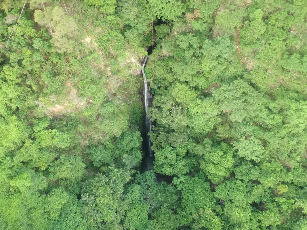
Dajin Waterfall is a large waterfall in Gaoshu township of Pingtung County. The hike here is relatively easy along a paved path, and there are great views of Pingtung along the way. It is definitely a fun trip in the mountains that will not take too much time, and a great place to enjoy nature.
Background: Dajin Waterfall is about 20 meters high, and falls at about 90 degrees. and its name comes from the roughly seven holes in the rocks between waterfalls. The holes in the rocks have been carved out of the rocks after thousands of years of erosion, and there is a rope climb and trail along the side of the waterfalls, which can be climbed in less than an hour. Currently the nearest parking lot lies on private property and the property owner collects parking fees in cash. Hours: 24/7 Price: Free Difficulty: Easy: 1 KM in length (one way) and 100 meters in elevation gain. The whole hike should take about an hour. Where to stay: Looking for a hotel? Find out where to stay in our Taiwan hotels guide or search for the best hotel deals in Taiwan here. We recommend booking through Agoda here, which provides the best quality selection of accommodation in Taiwan. I have stayed at many hostels and hotels in Pingtung, and even almost bought a house here. Some places that I have stayed at and can recommend are Nanwan Kiki (book on Agoda here, Booking.com here), a B&B next to Nanwan Bay, Kenting's most popular Beach. There are also a few decent hotels near Kenting Street Night Market like Kenting Star Inn 888 (book on Agoda here, Klook here, or Booking.com here), or Kenting Dajianshan Hotel (book on Agoda here or Booking.com here). You will notice that none of these hotels are five star resorts (I do not come to Kenting to waste my time at a resort, but you can still search Agoda, Booking.com, or Klook here for those) but they are in my opinion the above have the best value for the money. Tours: You can go book a river trace in Pingtung on Klook here or KKday here. How to get there: By Car/Scooter: From Pingtung, take Provincial Highway 27 northeast until you reach Xinfeng Village in Gaoshu and then turn southeast until you hit the mountains. Drive to the end of the road and that is where the trailhead starts. Looking for scooter rental in Kenting? Click here or here to search for options. You can also check out our Taiwan scooter rental guide here. Looking for scooter rental in Pingtung? Click here or here to search for options. If you are looking for car rentals, you can also search Qeeq here, Klook here, or KKday here. You can also check out our car rental guide here. By Bus: You can take bus 8218 bus to Weiliao Station, but then it is a 30 minute walk to the trailhead. You can book tickets to Pingtung via high speed rail (HSR) on Klook here or KKDay here, or book tickets via the normal train (TRA) on Klook here. You can book tickets to travel to Pingtung via inter-city bus on Klook here. By Bicycle: Cycling is the best way to enjoy Taiwan's landscapes if you have the time and energy. Looking for bicycle rentals in Taiwan? You can search on KKday here and search for tours on Klook here. You can also check out our Taiwan cycling guide here. Map: Please see below: 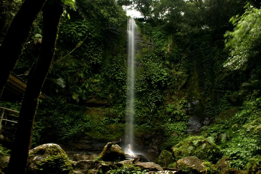
Paozilun Waterfall is a tall waterfall in Shenkeng District of New Taipei. The hike here is super easy, and there is a metal rack you can sit on to get massaged by the falling water. It is definitely a fun trip in the mountains that will not take too much time, and is part of a longer trail system through the tea fields in Shenkeng.
Background: Paozilun Waterfall is about 20 meters high, and its name comes from the Paozilun River which it is a part of. It lies on the Paozilun industrial road and can be a bit hard to find, and lies among agricultural land and tea fields. During the Qing Dynasty, the town of Shenkeng was an important stop along the Danlan Old Trail (淡蘭古道 which means the road between Tamsui and Yilan), which was split into three paths, and Shenkeng was on the Southern Path. The Southern Path winded from Mengjia Old Street to Liuzhangli, then to Shengkeng which was a major business center at the time. From Shenkeng the road then went to Shiding, Pinglin, and then Yilan. The Southern path was the quickest way to Yilan. After World War 2, the train to Yilan replaced the need for a boat dock for shipping in Shenkeng, and the town slowly fell out of importance. National Highway 3 and National highway 5 were constructed near Shenkeng in 1993 and 2006 respectively, making Shenkeng again an important stop on the way to Yilan. Currently tea is still an important crop in the mountains of Shenkeng. As for the Paozilun Trail, it is not super popular or well known and there is a good chance you will find yourself alone there on a weekend. Hours: 24/7 Price: Free Tours in Taipei: There are many tour itineraries that you can enjoy in Taipei that will take you to multiple destinations and arrange transportation. For more information, you can check out Tripadvisor here, KKday here or Klook here, which are both great tour websites that can connect you with the right tour and tour guide for you. Activities in Taipei: You can also look for more activities in Taipei such as Rock Climbing, Surfing, Speedboat Surfing, Diving, Snorkeling, Cooking Class, Glamping, Motorcycling, and more on Klook here or KKday here. Hotels in Taipei: We have stayed at and recommend the Yuanshan Grand Hotel, once the tallest building in Taiwan and still the most grand (book on Booking.com here, Tripadvisor here, or Agoda here). We have stayed at and also recommend Fu Chang Hotel in Ximending, which is within walking distance of Ximending shopping district (book on Booking.com here, Tripadvisor here, or Agoda here). Looking for a hotel? We recommend booking through Booking.com here, which provides the best quality selection of accommodation in Taiwan. Find out where to stay in our Taiwan hotels guide or search for the best hotel deals in Taiwan here. How to get there: By Car/Scooter: From Shenkeng Old Street, cross south across Highway 106 toward "Paozilun" and keep left on the road until you reach the point on the map below. There is no clear marker to the waterfall, so just follow the pictures below. There is plenty of parking on the side of the road. Looking for scooter rental in Taipei? You can search on Klook here or KKday here to search for options. You can also check out our scooter rental guide here. If you are looking for car rentals, you can also search Qeeq here, Klook here, or KKday here. You can also check out our car rental guide here. By Bus: Take bus F712 to Paozilun station, then walk a few hundred meters to the left up the hill until you reach the point on the map below. There is no clear marker to the waterfall, so just follow the pictures below. You can purchase a discount easy card to use on the MRT from Klook here or KKday here. You can also book an MRT travel pass on Klook here. By Bicycle: Cycling is the best way to enjoy Taiwan's landscapes if you have the time and energy. Looking for bicycle rentals in Taiwan? You can use Taiwan's many Youbike sharing stations, or search for rentals on KKday here, and search for tours on Klook here. You can also check out our Taiwan cycling guide here. ​You can also book a Sunset Riverside Bike Ride and Historical Tour, 4 Hour Cycling in Taipei, Ultimate 8-Hour Cycling City Tour, or Taipei City Bike Tour with Night Market Experience on TripAdvisor here. For more information, check out our Taiwan transportation guide here. Map: Please see below: 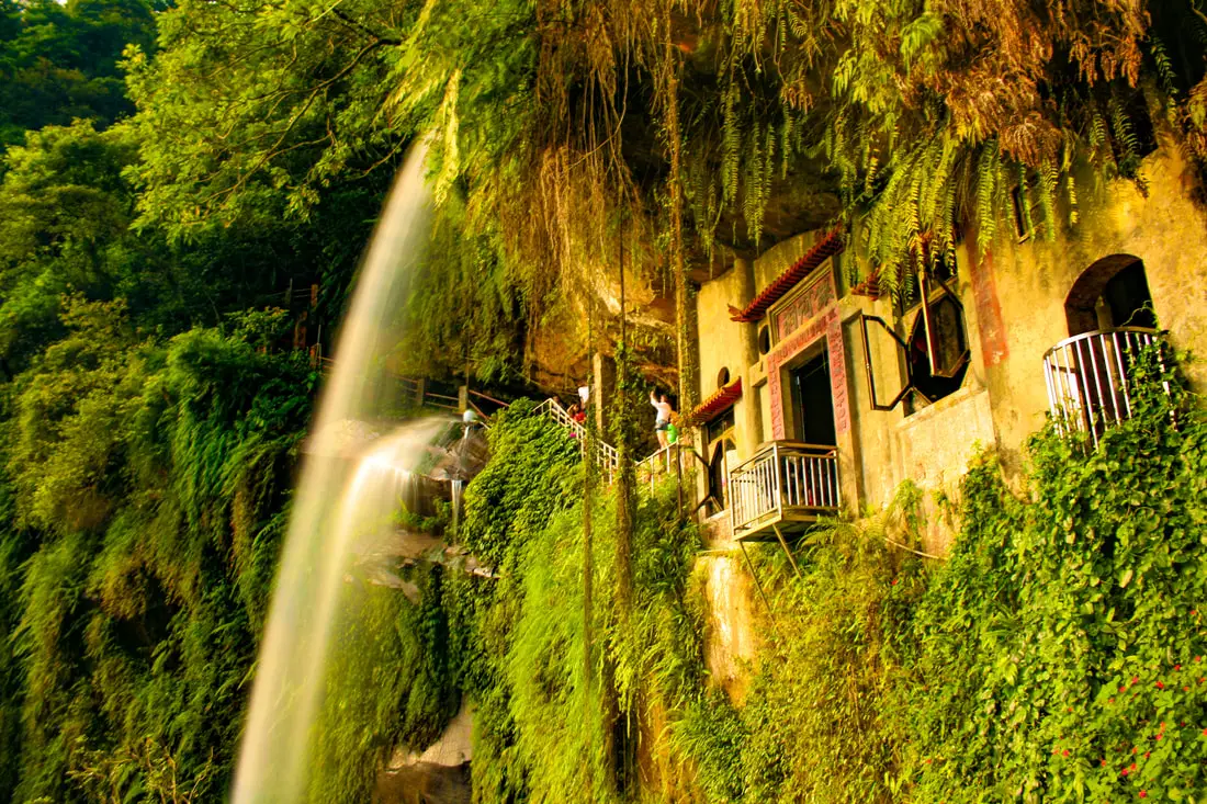
Yinhedong Waterfall (aka Yinhe Cave Waterfall) is an easily accessible sight in Xindian District of New Taipei, and perhaps the most picturesque in all of Taiwan. It is easily accessible by public transportation, and the hike takes less than ten minutes to get there from the trailhead. The waterfall includes a cave and temple that are great for taking phots. It's spectacular cascading falls are definitely worth a stop for anyone in Taiwan.
Background: Yinhedong Waterfall is about 30 meters high and is separated into two parts by a cave in the middle of the waterfall. It is located near the town of Xindian, and it's name literally means "Silver River Cave" or "Milky Way Cave." The waterfall lies a tributary of the Qingtan River which runs down tho the Xindian River, which runs into the Tamsui River. The rocks here easily erode, making for odd shapes in the riverbed. The earliest known discovery of the waterfall is by Chen Qiuju, who led a rebellion against the Japanese and used the cave as his hideout. The Japanese later discovered the cave and in 1914 a temple was built in the cave. The temple was renovated in 1958, and now the main god worshipped is Guanyin Bodhisattva. Now the waterfall is a popular attraction in the mountains of New Taipei with many other popular trails nearby. Hours: 24/7 Price: Free Tours in Taipei: There are many tour itineraries that you can enjoy in Taipei that will take you to multiple destinations and arrange transportation. For more information, you can check out Tripadvisor here, KKday here or Klook here, which are both great tour websites that can connect you with the right tour and tour guide for you. Activities in Taipei: You can also look for more activities in Taipei such as Rock Climbing, Surfing, Speedboat Surfing, Diving, Snorkeling, Cooking Class, Glamping, Motorcycling, and more on Klook here or KKday here. Hotels in Taipei: We have stayed at and recommend the Yuanshan Grand Hotel, once the tallest building in Taiwan and still the most grand (book on Booking.com here, Tripadvisor here, or Agoda here). We have stayed at and also recommend Fu Chang Hotel in Ximending, which is within walking distance of Ximending shopping district (book on Booking.com here, Tripadvisor here, or Agoda here). Looking for a hotel? We recommend booking through Booking.com here, which provides the best quality selection of accommodation in Taiwan. Find out where to stay in our Taiwan hotels guide or search for the best hotel deals in Taiwan here. How to get there: By Gondola: From Xindian MRT station, you can take the green 12 bus to Yinhedong Station. According the Google the fastest way to get to Yinhe Cave from central Taipei is by taking the Maokong Gondla to Maokong Station, then taking the trail down to Yinhe Road and the waterfall trail entrance. I't about a hal hour or 2KM walk from the Maokong Gondola to the trail entrance. You can purchase a discount easy card to use on the MRT from Klook here or KKday here. You can also book an MRT travel pass on Klook here. By Car/Scooter: Take provincial highway 9 east from Xindian toward Pinglin, then turn left off the main highway once you reach Yinhe Road. The waterfall is to the right of the first switchback in the road, and car and scooter parking are free on the side of the road near the entrance. Looking for scooter rental in Taipei? You can search on Klook here or KKday here to search for options. You can also check out our scooter rental guide here. If you are looking for car rentals, you can also search Qeeq here, Klook here, or KKday here. You can also check out our car rental guide here. By Bicycle: Cycling is the best way to enjoy Taiwan's landscapes if you have the time and energy. Looking for bicycle rentals in Taiwan? You can use Taiwan's many Youbike sharing stations, or search for rentals on KKday here, and search for tours on Klook here. You can also check out our Taiwan cycling guide here. You can also book a Sunset Riverside Bike Ride and Historical Tour, 4 Hour Cycling in Taipei, Ultimate 8-Hour Cycling City Tour, or Taipei City Bike Tour with Night Market Experience on TripAdvisor here. For more information, check out our Taiwan transportation guide here. Map: Please see below 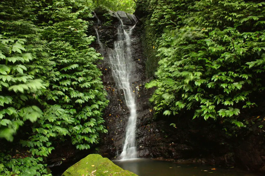
Dajianshan Waterfall (aka Dajianshan Falls) is a set of waterfalls in Xizhi District of New Taipei City, Taiwan. It a somewhat difficult and steep hiking path that takes about an hour to walk up, and includes a six main tiers of waterfall and amazing natural scenery. It's spectacular cascading falls and pools have made it a most popular destination in the area.
Background: Dajianshan Waterfall is roughly 200 meters high (650 feet) from the lowest falls to the highest falls, and is broken up by six sections of waterfalls. The rock formations that form the Waterfalls formed as sediment under the ocean millions of years ago and were then uplifted thanks to the collision of the Eurasian and Philippine plates. The rocks are mainly sedimentary and are part of the same formation that forms the special rock formations on the northern coast around Keelung. The rocks here easily erode, making for odd shapes in the riverbed. Due to the difficult nature of the trail, it is usually free of people, even on weekends. Hours: 24/7 Price: Free When to go: Go in the spring time when there is more rain. If you go during the dry season, the waterfall will be quite small. Difficulty: Moderate, 200 meter elevation gain. Takes about an hour to complete. Tours and Activities: You can book a river tracing experience at Dajianshan Waterfall on KKday here. Hotels in Taipei: High end: We have stayed at and recommend the Yuanshan Grand Hotel, once the tallest building in Taiwan and still the most grand (book on Booking.com here, Tripadvisor here, or Agoda here). We also recommend Fullon Hotel which has locations in Tamsui and Fulong near the beach (book on Booking.com here, Tripadvisor here, Agoda here, or Hotels.com here). Looking for a hotel? We recommend booking through Booking.com here, which provides the best quality selection of accommodation in Taiwan. Find out where to stay in our Taiwan hotels guide or search for the best hotel deals in Taiwan here. How to get there: By Bus: From Xizhi TRA station, take bus F911 to Fuji Mountain Villa stop, then walk through the neighborhood, which will take you to a mountain road on the back side. The waterfall is about a 15 minute walk from Fuji Mountain Villa. You can purchase a discount easy card to use on the MRT from Klook here or KKday here. You can also book an MRT travel pass on Klook here. By Car/Scooter: From provincial highway 5 in Xizhi, turn up the mountain after reaching the Xizhi Administrative Building (汐止行政中心). Then go up the mountain and turn into Xiufeng Road, aka Fuji Mountain Villa. After that, drive through the neighborhood, which will take you to a mountain road on the back side. The waterfall is about a 3 minute ride from Fuji Mountain Villa, on the switchback just before Qiedong Waterfall. Looking for scooter rental in Taipei? You can search on Klook here or KKday here to search for options. You can also check out our scooter rental guide here. If you are looking for car rentals, you can also search Qeeq here, Klook here, or KKday here. You can also check out our car rental guide here. By Bicycle: Cycling is the best way to enjoy Taiwan's landscapes if you have the time and energy. Looking for bicycle rentals in Taiwan? You can use Taiwan's many Youbike sharing stations, or search for rentals on KKday here, and search for tours on Klook here. You can also check out our Taiwan cycling guide here. You can also book a Sunset Riverside Bike Ride and Historical Tour, 4 Hour Cycling in Taipei, Ultimate 8-Hour Cycling City Tour, or Taipei City Bike Tour with Night Market Experience on TripAdvisor here. For more information, check out our Taiwan transportation guide here. Map: Please see below 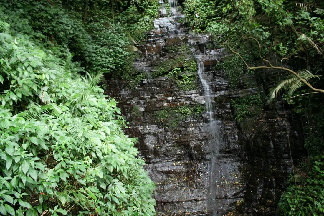
Xiufeng Waterfall is a tall waterfall in Xizhi District in New Taipei, Taiwan. It is easily accessible via a flat hiking path that takes about 10 minutes to complete, and includes amazing views of Taipei along the way. It's spectacular cascading falls are definitely worth a stop for anyone in Taiwan.
Background: Xiufeng Waterfall is roughly 10 meters high and 2 meters wide (32 x 13 ft.). It is located on Dajianshan in Xizhi, and connects with other Dajianshan trails in the area. The rocks here easily erode, making for odd shapes in the riverbed. Hours: 24/7 Price: Free When to go: Go in the spring time when there is more rain. If you go during the dry season, the waterfall will be quite small. Difficulty: Easy Tours: You can book a river tracing experience near Xiufeng Waterfall on KKday here. Hotels in Taipei: High end: We have stayed at and recommend the Yuanshan Grand Hotel, once the tallest building in Taiwan and still the most grand (book on Booking.com here, Tripadvisor here, or Agoda here). We also recommend Fullon Hotel which has locations in Tamsui and Fulong near the beach (book on Booking.com here, Tripadvisor here, Agoda here, or Hotels.com here). Looking for a hotel? We recommend booking through Booking.com here, which provides the best quality selection of accommodation in Taiwan. Find out where to stay in our Taiwan hotels guide or search for the best hotel deals in Taiwan here. How to get there: By Train: Take the TRA to Xizhi Station, then take a bus up the mountain to Xiufeng Watefall stop. You can purchase a discount easy card to use on the MRT from Klook here or KKday here. You can also book an MRT travel pass on Klook here. By Car/Scooter: From central Taipei, take Provincial Highway 5 east toward Xizhi, turn up the mountain once you reach the Xizhi District Administrative building. The trailhead is on the right side of the road on a bend. Scooter parking is free at the entrance. Looking for scooter rental in Taipei? You can search on Klook here or KKday here to search for options. You can also check out our scooter rental guide here. If you are looking for car rentals, you can also search Qeeq here, Klook here, or KKday here. You can also check out our car rental guide here. By Bicycle: Cycling is the best way to enjoy Taiwan's landscapes if you have the time and energy. Looking for bicycle rentals in Taiwan? You can use Taiwan's many Youbike sharing stations, or search for rentals on KKday here, and search for tours on Klook here. You can also check out our Taiwan cycling guide here. You can also book a Sunset Riverside Bike Ride and Historical Tour, 4 Hour Cycling in Taipei, Ultimate 8-Hour Cycling City Tour, or Taipei City Bike Tour with Night Market Experience on TripAdvisor here. For more information, check out our Taiwan transportation guide here. Map: Please see below 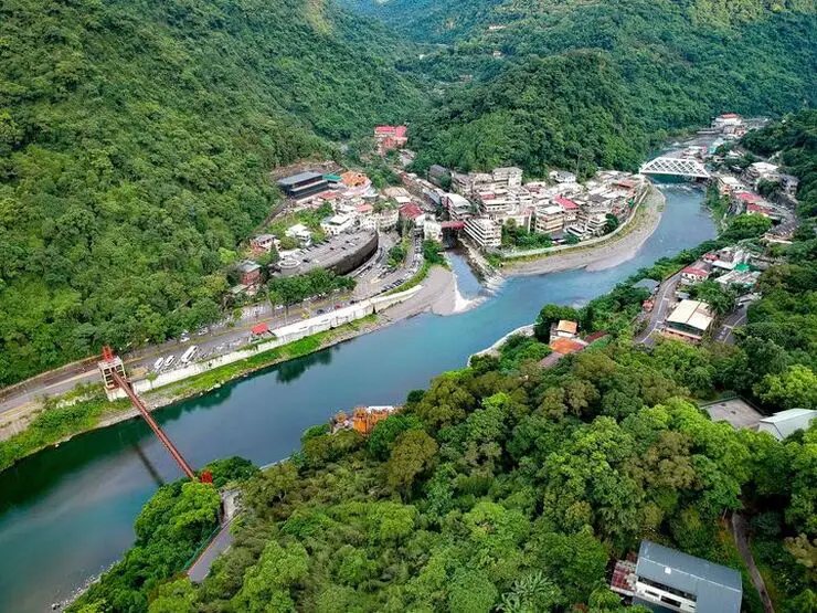
Wulai has become a major tourist attraction, partly because of its close proximity to Taipei. It has museums, waterfalls, a gondola, a train, an old street night market, and most of all hot springs. It has an old Japanese era coal mining railroad track which has been restored with a working train. In addition there are hikes, wildlife, and endless mountain scenery to explore.
Background: Wulai was originally an Atayal aborigine village, its name meaning hot and poisonous. There has always been natural hot springs in Wulai, but much of that water has been channeled into hotels and public bathhouses. The free hot springs stood at the bottom of the hill next to the river, and was a collection of used hot spring water from the hotels and paid hot springs above. In its prime, it boasted the largest free outdoor hot springs in Taiwan. Recently the District of Wulai in New Taipei has become a major tourist attraction, partly because of its close proximity to Taipei. It has museums, waterfalls, a gondola, a train, an old street night market, and most of all hot springs. The main delicacies on the old street are Taiwan ingenuous foods such as wild boar meat and rice steamed in bamboo. Hours: Wulai Old Street: Roughly 10 AM to 8 PM Cable Car and Yun Hsien Amusement Park Entrance: 9 AM to 4:30 PM You can book tickets to the gondola and to Yun Hsien theme park on Klook here or KKday here. Neidong Waterfall: 8 AM to 5 PM. You can book tickets to Neidong Forest Recreation Area on KKday here or Klook here. Price: Wulai Old Street: Free Cable Car and Yun Hsien Amusement Park Entrance: 220 NT per person You can book tickets to the gondola and to Yun Hsien theme park on Klook here or KKday here. Neidong Waterfall: 65 NT per person. You can book tickets on KKday here or Klook here. Hot Spring Bath: 300-500 NT. You can look for hot spring bath experiences on Klook here or KKday here. Delicacies: Wilde Boar meat, hot spring eggs, rice steamed in bamboo, among others. Hotels in Wulai: There are many hot spring hotels in Wulai that have a hot spring tub right in the room. We have stayed at and recommend Wulai SungLyu Hot Spring Resort, which is a hot spring resort with great views just above Wulai Old Street. You can book on Booking.com here, Agoda here, Hotels.com here, TripAdvisor here, Trip.com here, Klook here, Kayak here, or Expedia here. Looking for a hotel? We recommend booking through Booking.com here, which provides the best quality selection of accommodation in Taiwan. Find out where to stay in our Taiwan hotels guide or search for the best hotel deals in Taiwan here. How to get there: By Bus: From central Taipei, take bus 849 to Wulai Old Street. The trips takes about an hour and a half. You can purchase a discount easy card to use on a bus to Wulai on Klook here or KKday here. You can also book a Taipei travel pass on Klook here. By Car/Scooter: From Taipei, take provincial highway 9甲 to Wulai. There is a large paid parking garage in front of the old street. You may also be able to find free parking up the mountain. If you are looking for car rentals, you can also search Qeeq here, Klook here, or KKday here. You can also check out our car rental guide here. Looking for scooter rental in Taipei? You can search on Klook here or KKday here to search for options. You can also check out our scooter rental guide here. By Taxi: You can take short rides for about 150 NT, or hire a Taxi for a day for around 150 USD on Klook here. By Bicycle: Cycling is the best way to enjoy Taiwan's landscapes if you have the time and energy. Looking for bicycle rentals in Taiwan? You can use Taiwan's many Youbike sharing stations, or search for rentals on KKday here, and search for tours on Klook here. You can also check out our Taiwan cycling guide here. You can also book a Sunset Riverside Bike Ride and Historical Tour, 4 Hour Cycling in Taipei, Ultimate 8-Hour Cycling City Tour, or Taipei City Bike Tour with Night Market Experience on TripAdvisor here. For more information, check out our Taiwan transportation guide here. Map: Please see below of the places covered in this blog: 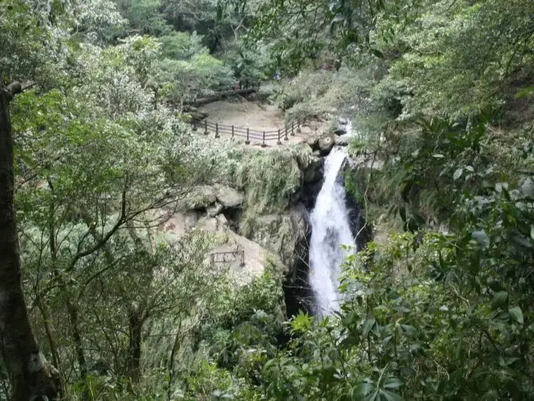
Full Moon Waterfall (Manyue Waterfall) lies in Sanxia's Manyueyuan National Forest Recreation Area in New Taipei. It's a beautiful waterfall and an easy family hike.
滿月圓瀑布位於新北市三峽區的滿月圓國家森林游樂區,是一個美麗的瀑布且容易的步道。 When to go: I actually recommend not going until the new tourist information center and Virgin Waterfall are opened up. That's right, Virgin Waterfall, the biggest waterfall in the park, is not even accessible, but you can still see Manyueyuan Waterfall for a discounted price. 其實我建議等到處女瀑布開放之後再去。對了,處女瀑布關閉了,整個公園最大的瀑布。但是滿月圓瀑布有優惠哦! Price: 80 NT You can book a ticket to Manyueyuan National Forest Recreation Area on KKday here. Hotels in Taipei: We have stayed at and recommend the Yuanshan Grand Hotel, once the tallest building in Taiwan and still the most grand (book on Booking.com here, Tripadvisor here, or Agoda here). We have stayed at and also recommend Fu Chang Hotel in Ximending, which is within walking distance of Ximending shopping district (book on Booking.com here, Tripadvisor here, or Agoda here). Looking for a hotel? We recommend booking through Booking.com here, which provides the best quality selection of accommodation in Taiwan. Find out where to stay in our Taiwan hotels guide or search for the best hotel deals in Taiwan here. How to get there: To get there, the only way is by taking your own vehicle or taxi. According to the recreation area website, there are no buses to get there. 去那邊只能開車或搭計程車。本地區的網站說沒有公車。 Looking for scooter rental in Taipei? You can search on Klook here or KKday here to search for options. You can also check out our scooter rental guide here. If you are looking for car rentals, you can also search Qeeq here, Klook here, or KKday here. You can also check out our car rental guide here. Map: See a map of the waterfall below: 請參考以下的地圖: 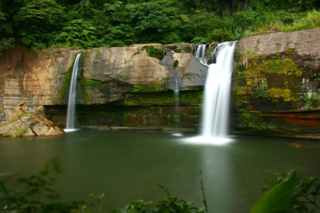
Lingjiao Waterfall (aka "Lingjiao Grotto Great Waterfall" 嶺腳石窟大瀑布) is a large waterfall and swimming hole right next to Lingjiao Station of the Pingxi Railway, on the Keelung River in Pingxi District of New Taipei. Its large cliffs are popular for jumping and has a large deep pool that is safe to swim in. Its accessibility via the Pingxi Railway has made it a popular spot, but most of the time there will not be any crowds there.
Background: Lingjiao Waterfall Is 40 meters wide and 11 meters tall, and is the second biggest waterfall in Pingxi District after Shifen Waterfall. The town of Lingjiao was named because it sits at the foot of a mountain (the name meaning literally "foot of the peak"). Lingjiao was a mining town on the Pingxi Railway, and a station there was completed during the Japanese Era in 1929. A few decades ago the waterfall was a popular spot for the locals who dug holes in the rocks at the base of the falls, so the waterfall is also known by the name "Lingjiao Grotto Great Waterfall" (嶺腳石窟大瀑布). The land around the falls was also once closed off and an admission was required, however due to mismanagement the business has long since closed down, so seeing the falls is now free. Price: Free Hours: 24/7 Tours of Pingxi: You can book a tour to Shifen on TripAdvisor here, Klook here, or KKday here. There are many tour itineraries that you can enjoy in Shifen that will take you to multiple destinations and arrange transportation. Activities Around Pingxi: Don't forget that there are many activities available around Pingxi such as Rock Climbing, Hiking, kayaking, canoeing, snorkeling, SUP / paddle boarding, water biking, Diving, River Tracing / Canyoneering, ATVing, Horse Riding, Cooking Class, photo shoot, Jingtong Sky Lantern Police Station, Shifen Sky Lantern Experience, Waterfall Zipline, Waterfall Diving, and more on Tripadvisor here, Klook here, or KKday here. Hotels Near Pingxi: We recommend Fullon Hotel which has locations in Tamsui and Fulong near the beach (book on Booking.com here, Tripadvisor here, Agoda here, or Hotels.com here). We have stayed at and recommend Gold Mountain Ranch, which is a horse ranch and glamping destination in Jinshan. You can book a night at Gold Mountain Ranch on Klook here. You can also check out our full blog on the ranch here. We have also stayed at and recommend Hai Xia Your Home which is right in front of Fulong Beach (book on Booking.com here, Tripadvisor here, Agoda here, or Hotels.com here). Looking for a hotel? We recommend booking through Booking.com here, which provides the best quality selection of accommodation in Taiwan. Find out where to stay in our Taiwan hotels guide or search for the best hotel deals in Taiwan here. How to get there: By Train: Take the TRA to Ruifang Station, and then switch to the Pingxi Railway line. Get off at Lingjiao Station, and then walk east down the road next to the train tracks, you will see the steps down to the waterfall on the right. Book tickets via the normal train (TRA) on Klook here. You can purchase a discount easy card to use on Pingxi Railway Line on Klook here or KKday here. You can also book a travel pass on Klook here. By Car/Scooter: Take provincial highway 2 east toward Pinglin, then get off the main highway once you reach Shifen. Then turn right and go west on county road 106 until you reach the Lingjiao Station turnoff. After that, you can park next to the train tracks and walk east down the road next to the train tracks, you will see the steps down to the waterfall on the right. If you are looking for car rentals, you can also search Qeeq here, Klook here, or KKday here. You can also check out our car rental guide here. Looking for scooter rental in Taipei? You can search on Klook here or KKday here to search for options. You can also check out our scooter rental guide here. By Taxi: You can take short rides for about 150 NT, or hire a Taxi for a day for around 150 USD on Klook here. By Bus: You can also book tickets to travel to Shifen via inter-city bus on Klook here. You can also book a Taipei Sightseeing: Hop On, Hop Off Open Top Bus on TripAdvisor here. By Bicycle: Cycling is the best way to enjoy Taiwan's landscapes if you have the time and energy. Looking for bicycle rentals in Taiwan? You can use Taiwan's many Youbike sharing stations, or search for rentals on KKday here, and search for tours on Klook here. You can also check out our Taiwan cycling guide here. You can also book a Sunset Riverside Bike Ride and Historical Tour, 4 Hour Cycling in Taipei, Ultimate 8-Hour Cycling City Tour, or Taipei City Bike Tour with Night Market Experience on TripAdvisor here. For more information, check out our Taiwan transportation guide here. Map: Please see below: 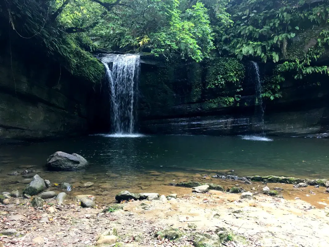
Wanggu Waterfall is a less known set of four waterfalls near Wanggu Station on the Pingxi Railway Line, located in Pingxi District of New Taipei. The short hike from Wanggu Station will take you to a series of waterfalls, with the second waterfall being the biggest. The trail is a pleasant hike and also a relaxing place to swim.
To read a great blog about this place in Chinese, check Willy Chang's incredibly extensive blog of the area here, from which I have pulled some information. 我不會把這篇翻成中文因爲“放羊的狼”已經寫了一篇更完整的中文部落格在這裡。 Background: The Pingxi Railway was completed in 1921 during the Japanese Era of Taiwan mainly to transport coal in the area. Wanggu Station was completed in only 1972 as the coal industry was gradually declining. It is an unmanned station, where you are on your honor to buy a ticket and the station you get off at because there is no one working at the station (or use an Easy Card). Wanggu Station was originally named Qinghe Station "慶和車站" after the main coal mine right next to it, but was later named to Wanggu Station in 1989. There is a broken suspension bridge near the train station, nemed Qinghe Suspension Bridge (慶和吊橋) that used to ship coal from another mine across the Keelung River before it was brought to Wanggu Station. By the 1990's, Taiwan's coal mining industry was in decline, and it was hard to produce cheap local coal. As of 2017, there was an average of 18 people a day arriving or leaving from Wanggu Station. Hours: 24/7 Price: Free Tours and Activities: Don't forget that there are many activities available around Pingxi such as Rock Climbing, Hiking, Waterfall Zipline, Waterfall Diving, and more on Tripadvisor here, Klook here, or KKday here. Hotels Near Pingxi: We recommend Fullon Hotel which has locations in Tamsui and Fulong near the beach (book on Booking.com here, Tripadvisor here, Agoda here, or Hotels.com here). We have stayed at and recommend Gold Mountain Ranch, which is a horse ranch and glamping destination in Jinshan. You can book a night at Gold Mountain Ranch on Klook here. You can also check out our full blog on the ranch here. We have also stayed at and recommend Hai Xia Your Home which is right in front of Fulong Beach (book on Booking.com here, Tripadvisor here, Agoda here, or Hotels.com here). Looking for a hotel? We recommend booking through Booking.com here, which provides the best quality selection of accommodation in Taiwan. Find out where to stay in our Taiwan hotels guide or search for the best hotel deals in Taiwan here. How to get there: By Train: Take the TRA to Ruifang Station, and then switch to the Pingxi Railway line. Get off at Wanggu Station, and then walk west down the road up the bridge and over the train tracks, you will see the trail to the waterfall at the top of the bridge. Book tickets via the normal train (TRA) on Klook here. You can purchase a discount easy card to use on Pingxi Railway Line on Klook here or KKday here. You can also book a travel pass on Klook here. By Car/Scooter: Take provincial highway 2 east toward Pinglin, then get off the main highway once you reach Shifen. Then turn right and go west on county raod 106 until you reach the Wanggu Station turnoff. After that, you have to drive on a narrow road between old buildings and the train tracks, then cross over the tracks to the hiking trail entrance. Parking is free and plentiful along the road. If you are looking for car rentals, you can also search Qeeq here, Klook here, or KKday here. You can also check out our car rental guide here. Looking for scooter rental in Taipei? You can search on Klook here or KKday here to search for options. You can also check out our scooter rental guide here. By Taxi: You can take short rides for about 150 NT, or hire a Taxi for a day for around 150 USD on Klook here. By Bus: You can also book tickets to travel to Shifen via inter-city bus on Klook here. You can also book a Taipei Sightseeing: Hop On, Hop Off Open Top Bus on TripAdvisor here. By Bicycle: Cycling is the best way to enjoy Taiwan's landscapes if you have the time and energy. Looking for bicycle rentals in Taiwan? You can use Taiwan's many Youbike sharing stations, or search for rentals on KKday here, and search for tours on Klook here. You can also check out our Taiwan cycling guide here. You can also book a Sunset Riverside Bike Ride and Historical Tour, 4 Hour Cycling in Taipei, Ultimate 8-Hour Cycling City Tour, or Taipei City Bike Tour with Night Market Experience on TripAdvisor here. For more information, check out our Taiwan transportation guide here. Map: Please see below: 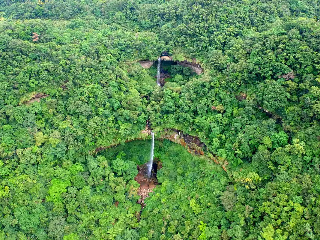
In an area full of majestic waterfalls, Sandiaoling's Three Tiered Waterfall Trail near Sandiaoling Station could be the most spectacular, with three large waterfalls over 30 meters tall in a row next to each other.
Background: There are many waterfalls along the Keelung River valley which runs through Pingxi and Ruifang; this is due to easily eroding sedimentary rock that makes up the terrain, which also makes for odd shapes and holes along rivers. The Sandiaoling waterfalls lie on a tributary of the Keelung River, in a mountain valley above the former mining village of Sandiaoling. Coming from Sandiaoling, the first waterfall you will see on the trail is Hegu Waterfall (合谷瀑布) which consists of two falls, the higher falls are 25 meters high and 9 meters wide, and the lower falls are 15 meters high and 6 meters wide. The second or middle waterfall is Motian Waterfall (摩天瀑布) which is 41 meters tall and 7 meters wide; it perhaps the tallest waterfall along the Pingxi Railway. The third or highest waterfall along the trail is Pipa Waterfall (aka Pipadong Waterfall 枇杷洞瀑布), and is about 31 meters high. Difficulty: This hike is moderately challenging; the whole hike take about an hour or two but there are ropes, chains, and ladders along the way, making for some gnarly climbs near the the top two waterfalls. Hours: 24/7 Price: Free Tours of Pingxi: You can book a tour to Pingxi on TripAdvisor here, Klook here, or KKday here. There are many tour itineraries that you can enjoy in Shifen that will take you to multiple destinations and arrange transportation. Activities Around Pingxi: Don't forget that there are many activities available around Pingxi such as Rock Climbing, Hiking, kayaking, canoeing, snorkeling, SUP / paddle boarding, water biking, Diving, River Tracing / Canyoneering, ATVing, Horse Riding, Cooking Class, photo shoot, Jingtong Sky Lantern Police Station, Shifen Sky Lantern Experience, Waterfall Zipline, Waterfall Diving, and more on Tripadvisor here, Klook here, or KKday here. Hotels Near Pingxi: We recommend Fullon Hotel which has locations in Tamsui and Fulong near the beach (book on Booking.com here, Tripadvisor here, Agoda here, or Hotels.com here). We have stayed at and recommend Gold Mountain Ranch, which is a horse ranch and glamping destination in Jinshan. You can book a night at Gold Mountain Ranch on Klook here. You can also check out our full blog on the ranch here. We have also stayed at and recommend Hai Xia Your Home which is right in front of Fulong Beach (book on Booking.com here, Tripadvisor here, Agoda here, or Hotels.com here). Looking for a hotel? We recommend booking through Booking.com here, which provides the best quality selection of accommodation in Taiwan. Find out where to stay in our Taiwan hotels guide or search for the best hotel deals in Taiwan here. How to get there: By Train: Take the TRA to Ruifang Station, and then switch to the Pingxi Railway line. Get off at Sandiaoling Station, then walk along the tracks to Shuoren Elementary School (碩仁國小); the trail starts at the entrance of the school. Book tickets via the normal train (TRA) on Klook here. You can purchase a discount easy card to use on Pingxi Railway Line on Klook here or KKday here. You can also book a travel pass on Klook here. By Car/Scooter: Take provincial highway 2 east toward Pinglin, then get off the main highway once you reach Shifen. Then take highway 106 to Wufenliao (五分寮), and take the road down to the trail head, where there is plenty of free parking. From here the first waterfall you will come across is Pipadong Waterfall (coming down from above). You can also drive to Sandiaoling Station and use the directions above. If you are looking for car rentals, you can also search Qeeq here, Klook here, or KKday here. You can also check out our car rental guide here. Looking for scooter rental in Taipei? You can search on Klook here or KKday here to search for options. You can also check out our scooter rental guide here. By Taxi: You can take short rides for about 150 NT, or hire a Taxi for a day for around 150 USD on Klook here. By Bus: You can also book tickets to travel to Shifen via inter-city bus on Klook here. You can also book a Taipei Sightseeing: Hop On, Hop Off Open Top Bus on TripAdvisor here. By Bicycle: Cycling is the best way to enjoy Taiwan's landscapes if you have the time and energy. Looking for bicycle rentals in Taiwan? You can use Taiwan's many Youbike sharing stations, or search for rentals on KKday here, and search for tours on Klook here. You can also check out our Taiwan cycling guide here. You can also book a Sunset Riverside Bike Ride and Historical Tour, 4 Hour Cycling in Taipei, Ultimate 8-Hour Cycling City Tour, or Taipei City Bike Tour with Night Market Experience on TripAdvisor here. For more information, check out our Taiwan transportation guide here. Map: Please see below: 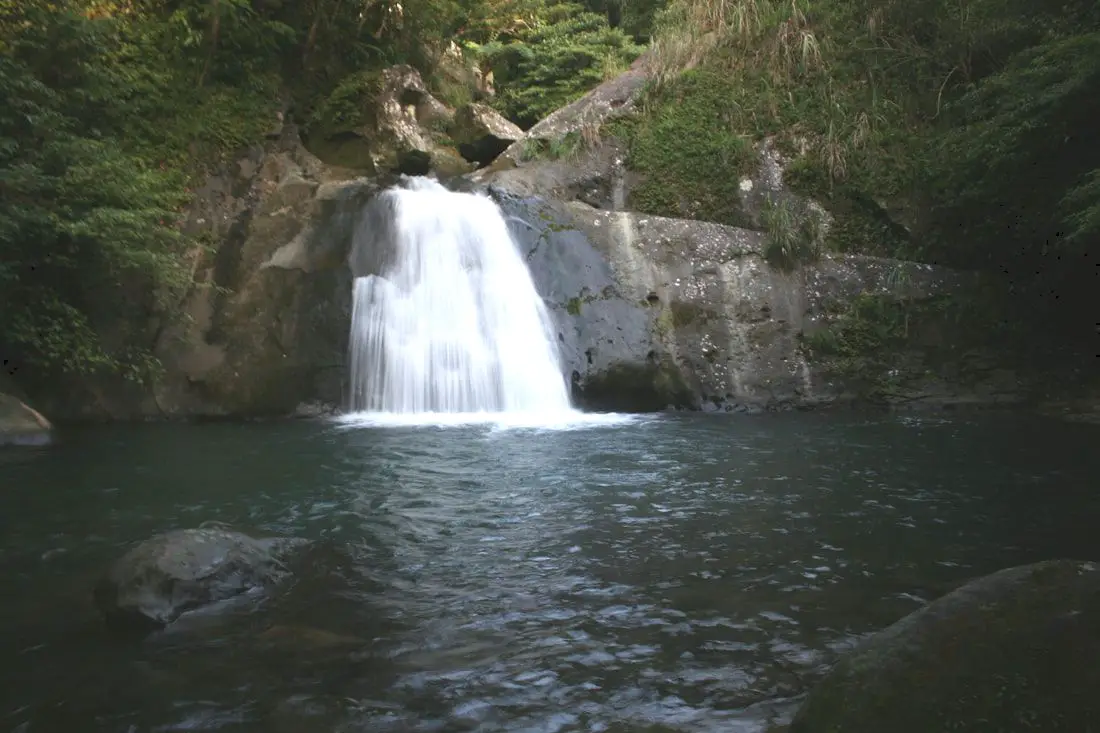
Huiyao Waterfall is a large waterfall and swimming hole near Wanggu Station on the Pingxi Railway, on a tributary of the Keelung River in Pingxi District of New Taipei. It's large cliffs are popular for jumping and has a large deep pool that is safe to swim in. It's lack of accessibility has made it a quiet location, and normally you will have the place to yourself.
Background: Huiyao Waterfall Is roughly 8 meters tall and only a few meters wide. The name Huiyao comes from the nearby mines, Hui meaning dust and Yao meaning coal pit. Just up river lay a few abandoned mines that were once used to transport coal back to Wanggu Station along the Pingxi Railway. The coal mine industry in Taiwan has collapsed due to low worldwide coal prices, with the last coal mine in Taiwan closing down around the year 2000. The sedimentary rock around Pingxi has made for easily eroding layers, which has created jagged peaks and large waterfalls, such as Sandiaoling, Shifen, Wanggu, and Lingjiao Waterfalls. Price: Free Hours: 24/7 Tours of Pingxi: You can book a tour to Pingxi on TripAdvisor here, Klook here, or KKday here. There are many tour itineraries that you can enjoy in Shifen that will take you to multiple destinations and arrange transportation. Activities Around Pingxi: Don't forget that there are many activities available around Pingxi such as Rock Climbing, Hiking, kayaking, canoeing, snorkeling, SUP / paddle boarding, water biking, Diving, River Tracing / Canyoneering, ATVing, Horse Riding, Cooking Class, photo shoot, Jingtong Sky Lantern Police Station, Shifen Sky Lantern Experience, Waterfall Zipline, Waterfall Diving, and more on Tripadvisor here, Klook here, or KKday here. Hotels Near Pingxi: We recommend Fullon Hotel which has locations in Tamsui and Fulong near the beach (book on Booking.com here, Tripadvisor here, Agoda here, or Hotels.com here). We have stayed at and recommend Gold Mountain Ranch, which is a horse ranch and glamping destination in Jinshan. You can book a night at Gold Mountain Ranch on Klook here. You can also check out our full blog on the ranch here. We have also stayed at and recommend Hai Xia Your Home which is right in front of Fulong Beach (book on Booking.com here, Tripadvisor here, Agoda here, or Hotels.com here). Looking for a hotel? We recommend booking through Booking.com here, which provides the best quality selection of accommodation in Taiwan. Find out where to stay in our Taiwan hotels guide or search for the best hotel deals in Taiwan here. How to get there: By Train: Take the TRA to Wanggu Station, and then walk the short distance up the hill and to the left to the Zunkou (圳口) Bus station on the south side of the road. Its then about a 30 minute walk up the road (2.2 KM) to the waterfall. Book tickets via the normal train (TRA) on Klook here. You can purchase a discount easy card to use on Pingxi Railway Line on Klook here or KKday here. You can also book a travel pass on Klook here. By Car/Scooter: Take provincial highway 2 east toward Pinglin, then get off the main highway once you reach Shifen. Then turn right and go west on county road 106 until you reach the the Zunkou (圳口) Bus station right in front of Wanggu station. Then drive up the road about 2 KM until you come to the waterfall. If you are looking for car rentals, you can also search Qeeq here, Klook here, or KKday here. You can also check out our car rental guide here. Looking for scooter rental in Taipei? You can search on Klook here or KKday here to search for options. You can also check out our scooter rental guide here. By Taxi: You can take short rides for about 150 NT, or hire a Taxi for a day for around 150 USD on Klook here. By Bus: You can also book tickets to travel to Shifen via inter-city bus on Klook here. You can also book a Taipei Sightseeing: Hop On, Hop Off Open Top Bus on TripAdvisor here. By Bicycle: Cycling is the best way to enjoy Taiwan's landscapes if you have the time and energy. Looking for bicycle rentals in Taiwan? You can use Taiwan's many Youbike sharing stations, or search for rentals on KKday here, and search for tours on Klook here. You can also check out our Taiwan cycling guide here. You can also book a Sunset Riverside Bike Ride and Historical Tour, 4 Hour Cycling in Taipei, Ultimate 8-Hour Cycling City Tour, or Taipei City Bike Tour with Night Market Experience on TripAdvisor here. For more information, check out our Taiwan transportation guide here. Map: Please see below: 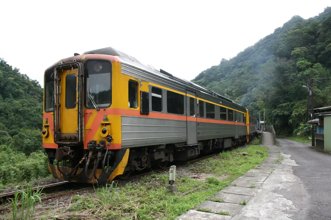
Dahua Station is one of the smallest, most remote, and less visited train stations on the Pingxi Railway. There are almost no commercialized attractions, but that has also made it a pristine nature area popular with hikers. Nearby one can see natural sites such as the Dahua potholes, waterfalls, forests, and wildlife, as well as historical mining sites.
Background: Dahua Station was completed in 1956, 35 years after the Pingxi Railway itself was completed. Its main purposes at the time was to ship coal and other mining materials from the nearby coal screening facility and also provide transportation for mine employees. In 1990, coal production at Dahua station stopped along with the gradual demise of the coal industry in Taiwan, due to low coal import prices and safety issues. In 1994, a small platform was built for tourists. Dahua station is unmanned. As of 2018, only an average of 18 people per day visited the station. Popular attractions near the train station include the Dahua Potholes, Cukeng Falls, Youkeng Falls, and Youkeng trail that connect Dahua Station to Sandiaoling Station. A lot of visitors mistakenly stop at Dahua Station while trying to walk to Shifen Waterfall. This is a mistake! It is a really long walk to Shifen Waterfall. You are best to just wait an hour for another oncoming train. Hours: 24/7 (first train comes at 5:32 AM, last train leaves at 10:30 PM, with one train coming every half hour or so) Tours of Shifen: You can book a tour to Shifen on TripAdvisor here, Klook here, or KKday here. There are many tour itineraries that you can enjoy in Shifen that will take you to multiple destinations and arrange transportation. Activities Around Pingxi: Don't forget that there are many activities available around Pingxi such as Rock Climbing, Hiking, kayaking, canoeing, snorkeling, SUP / paddle boarding, water biking, Diving, River Tracing / Canyoneering, ATVing, Horse Riding, Cooking Class, photo shoot, Jingtong Sky Lantern Police Station, Shifen Sky Lantern Experience, Waterfall Zipline, Waterfall Diving, and more on Tripadvisor here, Klook here, or KKday here. Hotels Near Pingxi: We recommend Fullon Hotel which has locations in Tamsui and Fulong near the beach (book on Booking.com here, Tripadvisor here, Agoda here, or Hotels.com here). We have stayed at and recommend Gold Mountain Ranch, which is a horse ranch and glamping destination in Jinshan. You can book a night at Gold Mountain Ranch on Klook here. You can also check out our full blog on the ranch here. We have also stayed at and recommend Hai Xia Your Home which is right in front of Fulong Beach (book on Booking.com here, Tripadvisor here, Agoda here, or Hotels.com here). Looking for a hotel? We recommend booking through Booking.com here, which provides the best quality selection of accommodation in Taiwan. Find out where to stay in our Taiwan hotels guide or search for the best hotel deals in Taiwan here. How to get there: By Train: Take the TRA to Ruifang Station, and then switch to the Pingxi Railway line. Get off at Dahua Station, and you have arrived! Book tickets via the normal train (TRA) on Klook here. You can purchase a discount easy card to use on Pingxi Railway Line on Klook here or KKday here. You can also book a travel pass on Klook here. By Car/Scooter: Take provincial highway 2 east toward Pinglin, then get off the main highway once you reach Shifen, then cross to the south of the Keelung River and take the Dahua Agricultural Road all the way to the end where you will find the station. There is no road that directly connects to Sandiaoling. If you are looking for car rentals, you can also search Qeeq here, Klook here, or KKday here. You can also check out our car rental guide here. Looking for scooter rental in Taipei? You can search on Klook here or KKday here to search for options. You can also check out our scooter rental guide here. By Taxi: You can take short rides for about 150 NT, or hire a Taxi for a day for around 150 USD on Klook here. By Bus: You can also book tickets to travel to Shifen via inter-city bus on Klook here. You can also book a Taipei Sightseeing: Hop On, Hop Off Open Top Bus on TripAdvisor here. By Bicycle: Cycling is the best way to enjoy Taiwan's landscapes if you have the time and energy. Looking for bicycle rentals in Taiwan? You can use Taiwan's many Youbike sharing stations, or search for rentals on KKday here, and search for tours on Klook here. You can also check out our Taiwan cycling guide here. You can also book a Sunset Riverside Bike Ride and Historical Tour, 4 Hour Cycling in Taipei, Ultimate 8-Hour Cycling City Tour, or Taipei City Bike Tour with Night Market Experience on TripAdvisor here. For more information, check out our Taiwan transportation guide here. Map: Please see below: 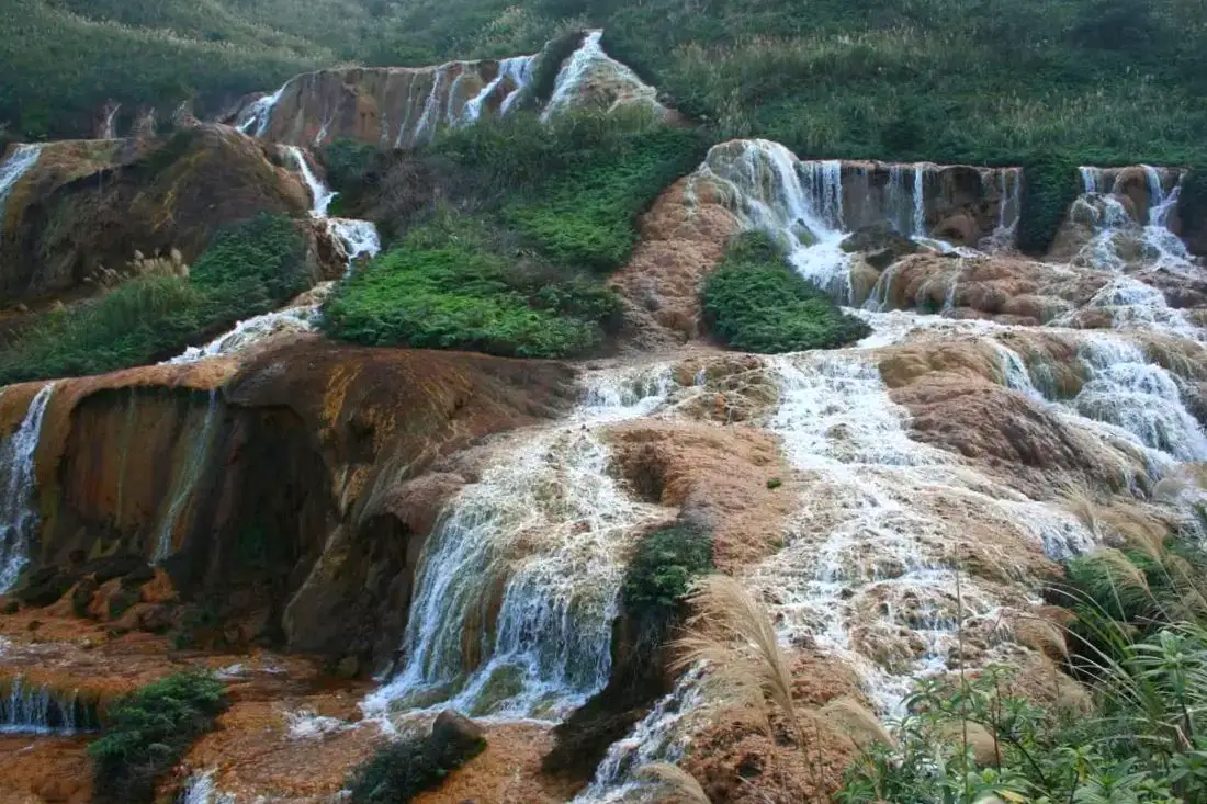
Another popular sight here is the golden waterfalls, which are colored gold because of the mine and mineral runoff collected as the water moves through old mines. Jinguashi is a small village in Ruifang District in New Taipei, famous for its now defunct mines. Here you can explore the Gold Mine Museum, touch a multi-million dollar gold ingot, see golden waterfalls, go on some of the best hikes in Taiwan, check out the old mining town, see Japanese era historic sites, and explore abandoned mining sites.
Historical Background: In 1890 during the Qing Dynasty, gold was found in the Keelung River during the construction of Taiwan's first railroad, which led to a small gold rush. Gold seams were eventually found in the mountains behind Jiufen around what is today Jinguashi. The name Jinguashui (金瓜石 Jīnguāshí), literally meaning "Gold Gourd Stone" comes from the shape of the nearby Keelung Mountain, which resembled a Pumpkin "Nánguā 南瓜" to early settlers, and the fact that early gold miners found lots of little gold seams resembling small gourds. After Taiwan was colonized by the Japanese in 1895, the Japanese quickly took control of the mines at Jinguashi, banning locals from owning mining rights. They quickly found many more copper and gold seams, and Jinguashi became the number one gold mine in the Japanese empire. During WWI, the mine came upon difficult times, and mining rights were passed to what is now Japan Energy, who built the 13 level complex that sits abandoned today. By 1938 it had become the most profitable gold mine in Asia, and population grew to over 80,000. During WWII, the mining operations switched from gold to copper, and the area was used as a POW camp. After the ROC took Taiwan, the mines were used mainly for copper, as the cost of refining gold was too high. The Chalet built for the crown prince of Japan at Jinguashi was later used by Chiang Kai-shek. After worldwide copper prices collapsed in the 1980s, the mine shut down for good in 1987. After that, people moved out of the town, and Jinguashi has a population of just about 2,000 people. Later mining initiatives have been met with strong criticism from environmentalists. In 2004, the New Taipei City Gold Mine Museum was completed, using several abandoned mining sites near Jinguashi, making it a popular tourist attraction in the area. Gold Mine Museum Hours: 9:30 AM to 5 PM, closed Mondays Gold Mine Museum Price: 80 NT per person (Free for New Taipei Residents) You can book discount tickets to the New Taipei Gold Mine Museum on Klook here or KKday here. Tours: You can book a tour to Golden Waterfall on TripAdvisor here, Klook here or KKday here. Hotels near Jinguashi: We recommend Fullon Hotel which has locations in Tamsui and Fulong near the beach (book on Booking.com here, Tripadvisor here, Agoda here, or Hotels.com here). We have stayed at and recommend Gold Mountain Ranch, which is a horse ranch and glamping destination in Jinshan. You can book a night at Gold Mountain Ranch on Klook here. You can also check out our full blog on the ranch here. We have also stayed at and recommend Hai Xia Your Home which is right in front of Fulong Beach (book on Booking.com here, Tripadvisor here, Agoda here, or Hotels.com here). Looking for a hotel? We recommend booking through Booking.com here, which provides the best quality selection of accommodation in Taiwan. Find out where to stay in our Taiwan hotels guide or search for the best hotel deals in Taiwan here. How to get There: By Train: Take TRA to Ruifang Station, then transfer to Keelung Bus which goes directly to Jinguashi every few minutes (about a 15 minute ride from Ruifang). Book tickets via the normal train (TRA) on Klook here. You can book tickets to the high speed rail (HSR) on Klook here or KKDay here. By Bus: Buses directly to Jinguashi leave from Taipei Main Station, Taipei City Hall, and Songshan Station regularly via Keelung Bus. You can also book a shuttle bus to Jiufen from Taipei on KKDay here. You can also book tickets to travel to Jiufen via inter-city bus on Klook here. By Car/Scooter: Take provincial highway 2 to Ruifang and then travel on highway 102 all the way up to Jiufen, then go over the mountain and keep going down to Jinguashi. Parking is scarce, and if you drive a car you need to park at the bottom of the hill and take the bus up to the gold mine museum. There is free scooter parking at the entrance. Looking for scooter rental in New Taipei? Click here or here to search for options. You can also check out our scooter rental guide here. If you are looking for car rentals, you can also search here. You can also check out our car rental guide here. By Taxi: You can take short rides for about 150 NT, or hire a Taxi for a day for around 150 USD. You can also charter a car for a day to Jinguashi on Klook here. By Bicycle: Cycling is the best way to enjoy Taiwan's landscapes if you have the time and energy. Looking for bicycle rentals in Taiwan? You can use Taiwan's many Youbike sharing stations, or search for rentals on KKday here, and search for tours on Klook here. You can also check out our Taiwan cycling guide here. You can also book a cycling tour on TripAdvisor here. For more information, check out our Taiwan transportation guide here. Map: Please see below: |
Author 作家I am an American expat who has extensive experience living, working, and traveling in Taiwan. In my day, I had to learn many things about Taiwan the hard way. But I have come to learn that Taiwan is one of the best places in the world for Foreigners to live. This blog does not represent the opinions of every foreigner in Taiwan. I am just trying to help others learn more about this beautiful country. Categories
|
 RSS Feed
