
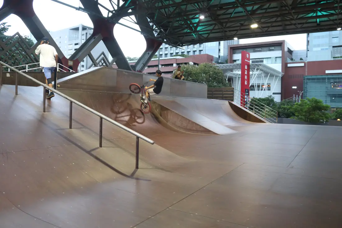
Taipei's Extreme Sports Training Center in Nangang is one of the best places in Taiwan to practice skateboarding, roller blading, BMX biking, etc. Here you can find Taiwan's largest half pipe, quarter pipes, a pool, rails, ramps, a foam pit, and more. It is definitely worth a stop if you want to find a suitable place for extreme sports training.
Background: The Taipei Extreme Sports Training Center began construction in 2010 with a budget of 50,000,000 NTD and it was completed in 2011. In the first ten years or so the park was free of any entrance fee for anyone to use. Maintenance was completed by the Taipei City Government Department of Sports. Later on, they found this was taking too much of the City's money, so they decided to let outside companies bid to use the space. Therefore now you have to pay a fee to get in, however they do take good care of the facilities now. The features in the park are quite intense. The park often features international competitions. Usually this place is not busy on weekdays but can get very busy on weekends including lots of parents taking small kids to practice here. Hours: 9 AM to 9 PM Price: 100 NT an hour 150 NT for two hours (the prices were 50% off when I visited due to the recent opening) Tours: You can book a tour of Taipei on Tripadvisor here, KKday here or Klook here. Where to stay: High end: We have stayed at and recommend the Nangang Marriott (book on Booking.com here or Agoda here). We have also stayed at and recommend the Yuanshan Grand Hotel, once the tallest building in Taiwan and still the most grand (book on Booking.com here or Agoda here). Looking for a hotel? We recommend booking through Booking.com here, which provides the best quality selection of accommodation in Taiwan. Find out where to stay in our Taiwan hotels guide or search for the best hotel deals in Taiwan here. How to get there: By Car/Scooter: The sports center is right next to Nangang MRT station on Zhongxiao East Road. There is paid parking at Nangang Station. Looking for scooter rental in Taipei? You can search on Klook here or KKday here to search for options. You can also check out our scooter rental guide here. If you are looking for car rentals, you can also search Qeeq here, Klook here, or KKday here. You can also check out our car rental guide here. By Bus/MRT: The sports center is right next to Nangang MRT station on Zhongxiao East Road. You can purchase a discount easy card to use on the MRT from Klook here or KKday here. You can also book an MRT travel pass on Klook here. By Bicycle: Cycling is the best way to enjoy Taiwan's landscapes if you have the time and energy. Looking for bicycle rentals in Taiwan? You can use Taiwan's many Youbike sharing stations, or search for rentals on KKday here, and search for tours on Klook here. You can also check out our Taiwan cycling guide here. You can also book a Sunset Riverside Bike Ride and Historical Tour, 4 Hour Cycling in Taipei, Ultimate 8-Hour Cycling City Tour, or Taipei City Bike Tour with Night Market Experience on TripAdvisor here. For more information, check out our Taiwan transportation guide here. Map: Please see below:
0 Comments
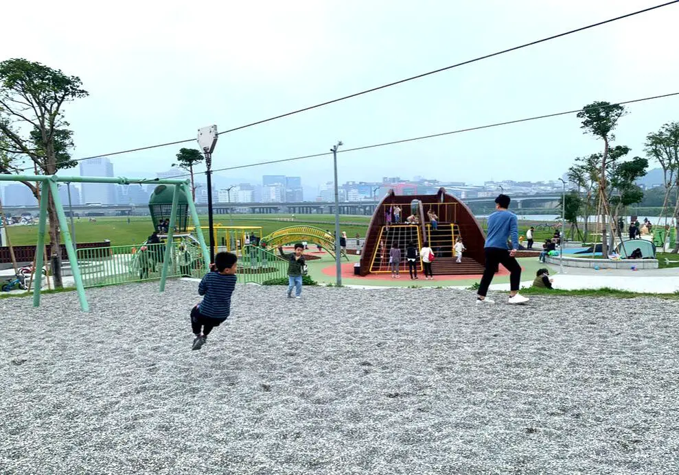
Guanshan Riverside Park is one of the best parks along the Keelung River in Taipei. Here you can find a bicycle practice loop, a zip line, trampolines, a sand pit, swings, a dog park, bike lanes, and large grassy areas. Also, the park is a great place for plane spotting as it sits right next to Songshan Airport. There is something here for everyone.
Background: Guanshan Riverside Park was formed around the year 2000 when the Keelung Riverside area was improved with levees. In 2023, a Wazaikeng Children's Park was formed inside Guanshan Riverside Park and includes a zip line, a sand pit, and swings. The area is popular with cyclists and plane spotters and can get busy on the weekends. Hotels in Taipei: High end: We have stayed at and recommend the Taipei Marriot (book on Booking.com here, Tripadvisor here or Agoda here). We have also stayed at and recommend the Yuanshan Grand Hotel, once the tallest building in Taiwan and still the most grand (book on Booking.com here, Tripadvisor here, or Agoda here). Looking for a hotel? We recommend booking through Booking.com here, which provides the best quality selection of accommodation in Taiwan. Find out where to stay in our Taiwan hotels guide or search for the best hotel deals in Taiwan here. Activities in Taipei: You can look for more activities in Taipei such as Rock Climbing, Surfing, Speedboat Surfing, Diving, Snorkeling, Cooking Class, Glamping, Motorcycling, and more on Klook here or KKday here. How to get there: By Car/Scooter: From Tayou Road turn into the flood gates in front of Guanshan Riverside Park. There is paid parking inside the park. Looking for scooter rental in Taipei? You can search on Klook here or KKday here to search for options. You can also check out our scooter rental guide here. If you are looking for car rentals, you can also search Qeeq here, Klook here, or KKday here. You can also check out our car rental guide here. By Bus/MRT: From Central Taipei, you can take bus 262 to Tayou Station. The park is within walking distance. You can purchase a discount easy card to use on the MRT from Klook here or KKday here. You can also book an MRT travel pass on Klook here. By Bicycle: Cycling is the best way to enjoy Taiwan's landscapes if you have the time and energy. Looking for bicycle rentals in Taiwan? You can use Taiwan's many Youbike sharing stations, or search for rentals on KKday here, and search for tours on Klook here. You can also check out our Taiwan cycling guide here. You can also book a Sunset Riverside Bike Ride and Historical Tour, 4 Hour Cycling in Taipei, Ultimate 8-Hour Cycling City Tour, or Taipei City Bike Tour with Night Market Experience on TripAdvisor here. For more information, check out our Taiwan transportation guide here. Map: Please see below: 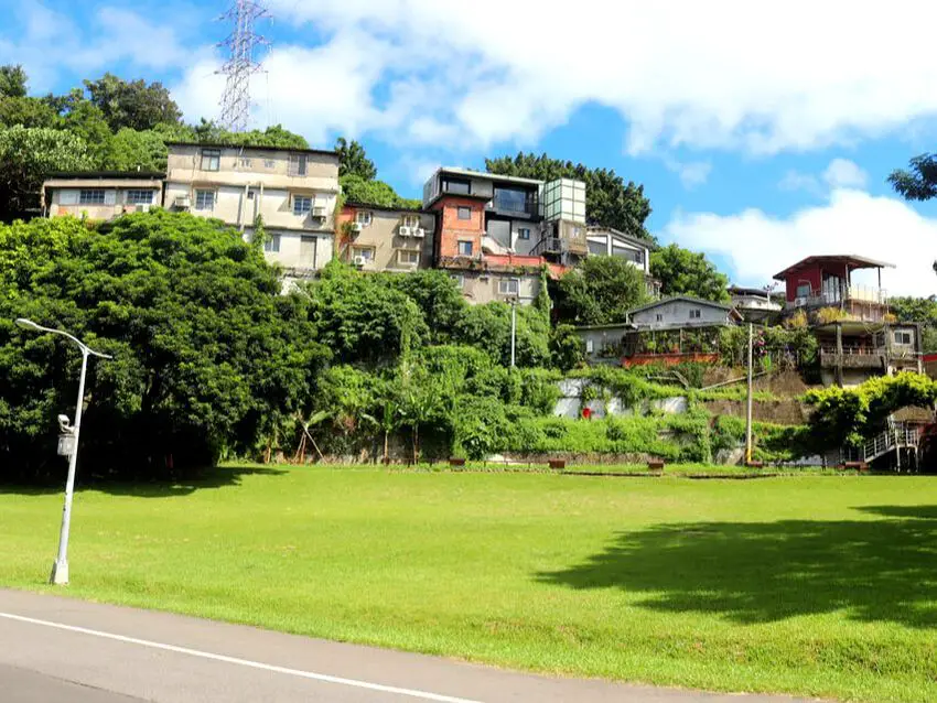
Treasure Hill is a former military dependents village in Taipei, which has been converted into an art village. In addition to understanding more about Taiwan's wartime history here, you can also appreciate the many art spaces and coffee shops in the village. This place is a hipster's paradise.
Background: Treasure Hill was originally an anti-aircraft location for the Japanese military during WWII. The barracks and dormitories leftover by the Japanese were later taken over by KMT army veterans after the KMT retreated to Taiwan in the late 1940's. There were also a few illegal structures added to the village made from cement and sand from the Xindian River. After 1960, the area was converted into a military dependents village for the families of army veterans. After years of no illegal renovations and add-ons. the Taipei City government planned to demolish the village in 1980, and some were destroyed. However, because the city could not find a place for the poor families that still lived there, the demolition was halted. In 2006 demolition of houses near the riverside was completed, and over 100 residents were moved out of the village. Later on, the remaining legal houses were converted into the international arts village, and a few residents were allowed to remain. Hours: Tuesday to Sunday 11 AM to 10 PM Price: Free Hotels in Taipei: High end: We have stayed at and recommend the Taipei Marriot (book on Booking.com here, Tripadvisor here or Agoda here). We have also stayed at and recommend the Yuanshan Grand Hotel, once the tallest building in Taiwan and still the most grand (book on Booking.com here, Tripadvisor here, or Agoda here). Looking for a hotel? We recommend booking through Booking.com here, which provides the best quality selection of accommodation in Taiwan. Find out where to stay in our Taiwan hotels guide or search for the best hotel deals in Taiwan here. Activities in Taipei: You can look for more activities in Taipei such as Rock Climbing, Surfing, Speedboat Surfing, Diving, Snorkeling, Cooking Class, Glamping, Motorcycling, and more on Klook here or KKday here. How to get there: By Car/Scooter: From Roosevelt Road, turn right toward Tingzhou Road Section 3. There is paid parking on the north entrance. Looking for scooter rental in Taipei? You can search on Klook here or KKday here to search for options. You can also check out our scooter rental guide here. If you are looking for car rentals, you can also search Qeeq here, Klook here, or KKday here. You can also check out our car rental guide here. By Bus/MRT: Take the MRT to Gonguan Station. The village is about a 10 minute walk away. You can purchase a discount easy card to use on the MRT from Klook here or KKday here. You can also book an MRT travel pass on Klook here. By Bicycle: Cycling is the best way to enjoy Taiwan's landscapes if you have the time and energy. Looking for bicycle rentals in Taiwan? You can use Taiwan's many Youbike sharing stations, or search for rentals on KKday here, and search for tours on Klook here. You can also check out our Taiwan cycling guide here. You can also book a Sunset Riverside Bike Ride and Historical Tour, 4 Hour Cycling in Taipei, Ultimate 8-Hour Cycling City Tour, or Taipei City Bike Tour with Night Market Experience on TripAdvisor here. For more information, check out our Taiwan transportation guide here. Map: Please see below: 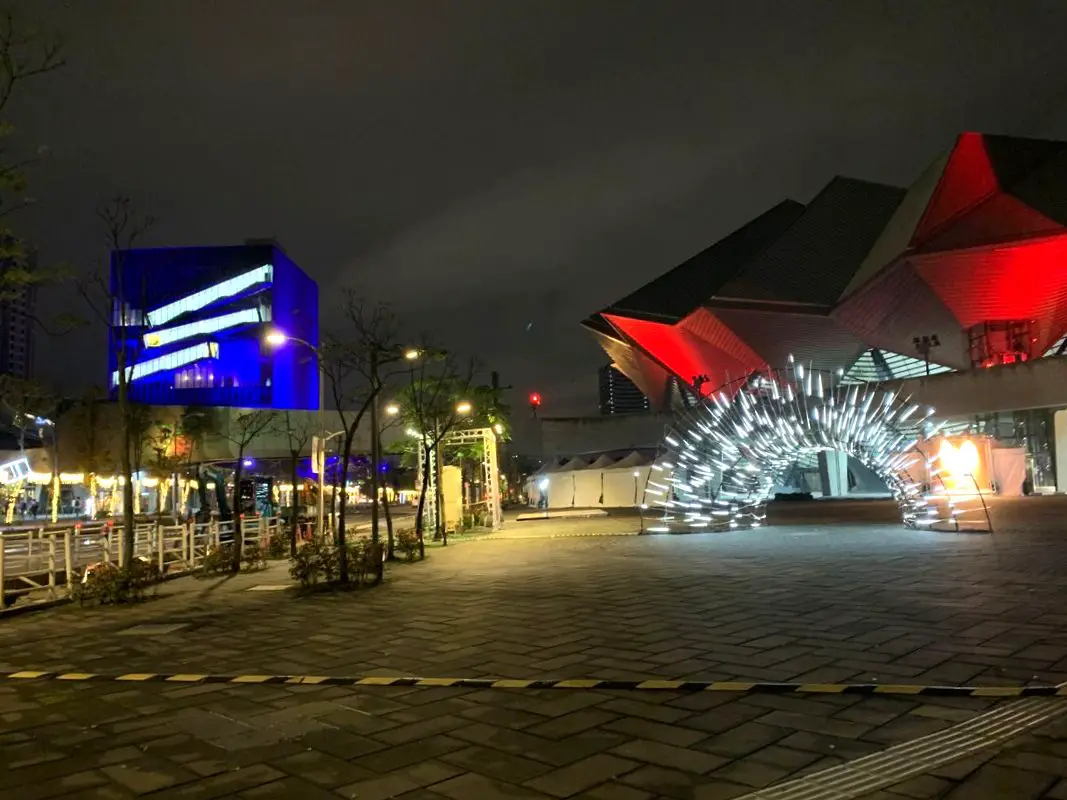
Taipei Music Center (aka TMC, or Taipei Pop Music Center 臺北流行音樂中心) is the first large performance area in Taiwan dedicated to pop music. It features three main buildings: a concert hall, a pop music cultural center, a creative hub building, and large open spaces and grassy areas. The area also has pedestrian bridges and easy access to Nangang Station. It should definitely be on your list on your next trip to Taipei.
Background: Planning for the Taipei Music Center first began in 2003 and construction began in 2013. The area was finally completed in 2020 and opened to the public in 2021. Total expenditure for the music center was over 6 billion NTD (193 million USD). It was designed by RUR Architecture, an American firm. The concert hall has 3,100 fixed seats, and at full capacity can fit about 5,000 people. Now the area is home to major music industry players and domestic and international music concerts. Website: Check out the latest concerts, festivals, and activities going on at their website here: https://tmc.taipei/en/ Price: Free entrance, concert prices may vary. Hours: 10 AM - 6 PM every day except Monday (concert times may vary) Tours: You can book a tour of Taipei on Tripadvisor here, KKday here or Klook here. Where to stay: High end: We have stayed at and recommend the Nangang Marriott (book on Booking.com here or Agoda here). We have also stayed at and recommend the Yuanshan Grand Hotel, once the tallest building in Taiwan and still the most grand (book on Booking.com here or Agoda here). Looking for a hotel? We recommend booking through Booking.com here, which provides the best quality selection of accommodation in Taiwan. Find out where to stay in our Taiwan hotels guide or search for the best hotel deals in Taiwan here. How to get there: By Car/Scooter: From Kunyang MRT station on Zhongxiao East Road, travel north until you reach the park. There is paid parking at Nangang Station. Looking for scooter rental in Taipei? You can search on Klook here or KKday here to search for options. You can also check out our scooter rental guide here. If you are looking for car rentals, you can also search Qeeq here, Klook here, or KKday here. You can also check out our car rental guide here. By Bus/MRT: Take the MRT to Kunyang Station or Nangang Station. The park is about a 10 minute walk from either station. You can purchase a discount easy card to use on the MRT from Klook here or KKday here. You can also book an MRT travel pass on Klook here. By Bicycle: Cycling is the best way to enjoy Taiwan's landscapes if you have the time and energy. Looking for bicycle rentals in Taiwan? You can use Taiwan's many Youbike sharing stations, or search for rentals on KKday here, and search for tours on Klook here. You can also check out our Taiwan cycling guide here. You can also book a Sunset Riverside Bike Ride and Historical Tour, 4 Hour Cycling in Taipei, Ultimate 8-Hour Cycling City Tour, or Taipei City Bike Tour with Night Market Experience on TripAdvisor here. For more information, check out our Taiwan transportation guide here. Map: Please see below: 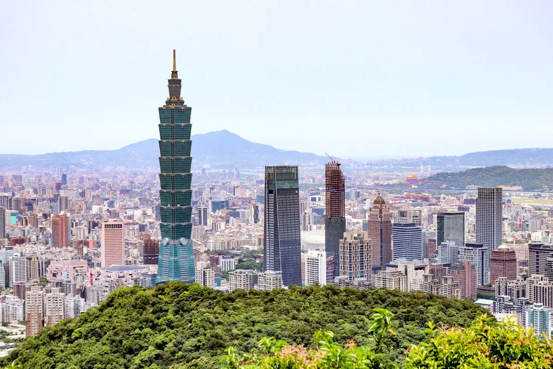
Are you wondering what to do, see, and eat during your trip to Taipei? We have all the answers here in this ultimate travel guide. From the abundant food options, night markets, historical sights, mountains, and natural beauty of the area, there are endless activities and sights to enjoy for any amount of time.
About the author: I am a long-time Taipei resident. So far I have lived over 7 years in Taipei City. Originally I am from the USA, but I now call Taiwan my home. Specifically, I currently live in Nangang District, but I have also lived in Da'an District and Sanchong. Exploring Taipei is my passion. Brief Historical Background of Taipei: The land on which Taipei now stands on what was once part of Basay tribal land. The Basay people had lived on the land for thousands of years before the first Chinese settlers ever came. Chinese settlers from Fujian began living here during the Dutch rule in the 1600s. The first Chinese settlers came to the area in the mid-1800's during the Qing Dynasty. They created a public area for drying rice and grain, called Dadaocheng (大稻埕) which also became the central market in the area. The earliest trading shops were built in 1851, mainly selling rice, sugar, camphor, and tea. Dihua Street (迪化街) was created around this time, making it the oldest street in Taipei. Most of the buildings were one story and made of red brick in Fujian style, and later western style houses were built. The walls and gates of Taipei were completed in 1884. In 1891, the first train connecting Keelung and Taipei was completed. During the Japanese era, in 1904 the walls of Taipei were destroyed after less than 30 years, and Taipei was re-planned into the capital of Taiwan. After the ROC took control of Taiwan, Taipei continued as the capital city, as well as the financial hub of Taiwan. During the Taiwan miracle, many rural families moved from southern Taiwan to factories and offices in Taipei, making Taipei the most populous urban area in Taiwan. Currently, Taipei is the most advanced and affluent city in Taiwan. It also has Taiwan's most advanced public transportation system, making it easy for millions of commuters to live outside the city where rents are cheaper. Now, most of Taiwan's economic activity is based in this city. Basic Taipei Travel Tips:
When should you go to Taipei? In my opinion, the best weather in Taipei is from March-May, and October - November, when the temperatures stay around 26 degrees Celsius and there is not as much rain. Summers are also nice, with the most sunny weather, but also hot and rainy. Winters can be cold (but not below freezing) and usually wet. Overall, there is no wrong answer as to what time of year you should visit Taipei. You will have a great time here at any time of year. Hotels in Taipei: High end: We have stayed at and recommend the Yuanshan Grand Hotel, once the tallest building in Taiwan and still the most grand (book on Booking.com here, Tripadvisor here, or Agoda here). We have also stayed at and recommend the Grand Hyatt (book on Booking.com here, Tripadvisor here, Agoda here, or Hotels.com here), Marriot (book on Booking.com here, Tripadvisor here, Agoda here, or Hotels.com here), Sheraton (book on Booking.com here, Tripadvisor here, Agoda here, or Hotels.com here), Shangri-la (book on Booking.com here, Tripadvisor here, Agoda here, or Hotels.com here), and Regent (book on Booking.com here, Tripadvisor here, Agoda here, or Hotels.com here), which are all very high quality hotels in the middle of Taipei City. We also recommend Fullon Hotel which has locations in Tamsui and Fulong near the beach (book on Booking.com here, Tripadvisor here, Agoda here, or Hotels.com here). Budget Hotels: We have stayed at and also recommend Fu Chang Hotel in Ximending, which is within walking distance of Ximending shopping district (book on Booking.com here, Tripadvisor here, or Agoda here). We have also stayed at and recommend Hai Xia Your Home which is right in front of Fulong Beach (book on Booking.com here, Tripadvisor here, Agoda here, or Hotels.com here). Looking for a hotel? We recommend booking through Booking.com here, which provides the best quality selection of accommodation in Taiwan. Find out where to stay in our Taiwan hotels guide or search for the best hotel deals in Taiwan here. Attractions in Taipei: There are many attractions that you can enjoy in Taipei such as Taipei 101 Observatory, Taipei 101 460 Skyline Observatory, Taipei Children's Amusement Park, Maokong Gondola, National Palace Museum, Yehliu Ocean World, Yehliu Geopark, National Museum of Marine Science and Biology, i-ride 5D cinema, Astronomical Museum, Miniatures Museum of Taiwan, Double Decker Sightseeing Bus, Miramar Ferris Wheel Ticket, Taipei Zoo, Heping Island Park, Ju Ming Museum, Yuanshan Hotel Secret Road, National Taiwan Museum, New Taipei Gold Museum, Futian Leisure Farm, Chiang Kai-shek Shilin Residence, Chi Po-lin Museaum, Beitou Museum, Tsao Wonderland, Railway Museum, Fort San Domingo, 13 Levels Archaeology Museum, Austin Land, Museum of World Religions, Formosan Aboriginies Museum, ASE Parent-child Park, teamLab Future Park, Yukids Island, VR Experience, Bat Cave, Neidong Waterfall, Candlestick Islet, Jurassic Snow Park, Zhonghe High5 Amusement Park, Longshan Temple, Xingtian Temple, Ningxia Night Market, Yansan Night Market, Meteor Garden, Yingge Old Street, and many more attractions on Tripadvisor here, Klook here, or KKday here. Activities in Taipei: Don't forget that there are many activities available in Taipei such as Indoor Skiing, Rock Climbing, Hiking, Wakeboarding, Surfing, Speedboat Surfing, SUP / Paddle Boarding, Diving, Snorkeling Kayaking, Canoeing, Water Biking, River Tracing / Canyoneering, ATVing, Horse Riding, Cooking Class, Archery, Ice Skating, Roller Skating, Tree Climbing, Urban Camping, Glamping, Motorcycling, Motorbike Tour, Dragon Boat Racing, Escape Room, Shen'ao Rail Bike, Laser Gun Experience, Batting Cages, Bowling, Paintball, Flight Simulation Experience, Taipei Tram Driving Experience, Rail Simulation Experience, Taipei 101 Observation Deck activity, Strawberry Picking, Professional Photo Shoot, Body Relaxation SPA, Night Tour, Calligraphy Workshop, and more on Tripadvisor here, Klook here, or KKday here. Just to let you know, if you book using the links above, we get some commission at no cost to you, and you can help support our blog. Some of the Klook links may not work if you are using an Ad blocker. You can click here to receive $5 USD on your first Klook purchase. How to get there: The only way to get to Taiwan is via airplane. Planes leave daily from Taipei's Songshan and Toayuan Airport. Taoyuan Airport: Taoyuan is Taiwan's largest airport and typically has cheaper flights and more flight times to choose from. It's about an hour's journey from Taoyuan Airport to the center of Taipei. You can travel via MRT, HSR, bus, or taxi to get to Taipei. You can get 30% off the Taoyuan Airport VIP lounge on KKday here. Songshan Airport: Songshan is a small airport in Taipei's city center, and can be a convenient option for people traveling within Asia. The airport is right on the Taipei MRT brown line. You can book cheap flights to Taiwan on KKday here, Trip.com here, CheapO Air here, or Kiwi here. How to get around in Taipei: Taipei's transportation system is convenient and safe. There are many options you can consider to get around in Taipei below: By Train: Gets you to the city center of all major cities in Taiwan. It is about 800NT to get from Taipei to Kaohsiung. Roughly half the price of the HSR. Book tickets via the normal train (TRA) on Klook here. By HSR: (High-Speed Rail) – Gets you quickly from north to south. Besides Taipei and Kaohsiung, most of the stations are far from city centers. It costs about 1500NT to get from Taipei to Kaohsiung. You can book tickets to the high-speed rail (HSR) on Klook here or KKDay here. By MRT: (Mass Rapid Transit, Metro train, subway) – Easily gets you around Taipei and Kaohsiung. You can purchase a discount easy card to use on the MRT from Klook here or KKday here. You can also book an MRT travel pass on Klook here. By Bus: Buses can be tricky. Long-range buses such as Ubus and King Bus are easier to understand and cheaper than the local train. They can take you to the city center of every city throughout Taiwan and to remote tourist destinations such as sun moon lake. A long-range bus from Taipei to Kaohsiung is about 500 NT. You can also book tickets to travel to Shifen via inter-city bus on Klook here. You can also book a Taipei Sightseeing: Hop On, Hop Off Open Top Bus on TripAdvisor here. By Taxi: You can take short rides for about 150 NT, or hire a Taxi for a day for around 150 USD. By Car: If you are looking for car rentals, you can also search Qeeq here, Klook here, or KKday here. You can also check out our car rental guide here. By Scooter: Looking for scooter rental in Taipei? You can search on Klook here or KKday here to search for options. You can also check out our scooter rental guide here. By Bicycle: Cycling is the best way to enjoy Taiwan's landscapes if you have the time and energy. Looking for bicycle rentals in Taiwan? You can use Taiwan's many Youbike sharing stations, or search for rentals on KKday here, and search for tours on Klook here. You can also check out our Taiwan cycling guide here. ​You can also book a Sunset Riverside Bike Ride and Historical Tour, 4 Hour Cycling in Taipei, Ultimate 8-Hour Cycling City Tour, or Taipei City Bike Tour with Night Market Experience on TripAdvisor here. For more information, check out our Taiwan transportation guide here. Tourist Site Map: Check out our map below of tourist sites in Taiwan, which is constantly updated: 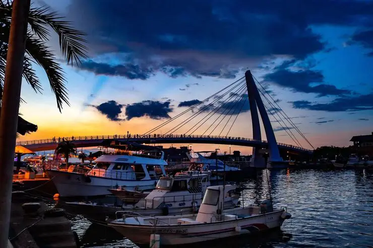
Tamsui District of New Taipei is famous for its delicious food and historical atmosphere. It is one of the most popular and well known areas in all of Taiwan. Some local delicacies here include A-gei, iron eggs, fried squid, and other seafood. Historical places near here include Fort San Domingo, Hobe Fort, Tamsui Old Street, Bali Old Street, and the Shihsanhang archaeological site. There is plenty here to see and do for almost every kind of traveler.
Historical Background of Tamsui: Tamsui Harbor was opened in 1860 during the Qing Dynasty as part of the Treaty of Tientsin which ended the Second Opium War. It was one of only eight ports in the entire Qing empire that was open to trade with the West. As a result, it became a focal point for trade in Taiwan. It was also the western terminus of the Danlan Old Trail, which was a network of roads and trails that sent tea and other goods from Yilan to Tamsui. It remained an important port until it started to silt in during the 1900s, and after the construction of Keelung Harbor. There are also a number of important historical buildings in Tamsui such as Fort San Domingo, Hobe Fort, and others. Recently there have been projects from the local government to improve tourism, such as widening roads and making a riverside walkway. With the completion of the Red Line MRT with its terminus in 1997 right at the edge of Tamsui Old Street, Tamsui became an extremely popular destination for residents in greater Taipei and remains to be so today. When should you visit Tamsui? In my opinion, the best weather in Tamsui is from March-May, and October - November, when the temperatures stay around 26 degrees Celsius and there is not as much rain. Summers are also nice, with the most sunny weather, but also hot and rainy. Winters can be cold (but not below freezing) and usually wet. Overall, there is no wrong answer as to what time of year you should visit Tamsui. You will have a great time here at any time of year. Hotels in Tamsui: We have stayed at and recommend Fullon Hotel which has locations in Tamsui and Fulong near the beach (book on Booking.com here, Tripadvisor here, Agoda here, Klook here, Trip.com, Kayak here, or Hotels.com here). We have also stayed at and recommend the Yuanshan Grand Hotel, once the tallest building in Taiwan and still the most grand (book on Booking.com here, Tripadvisor here, Agoda here, Trip.com here, or Kayak here). Looking for a hotel? We recommend booking through Booking.com here, which provides the best quality selection of accommodation in Taiwan. Find out where to stay in our Taiwan hotels guide or search for the best hotel deals in Taiwan here. Tours: You can book a tour of Tamsui on TripAdvisor here, KKday here, or Klook here. You can book a tour of Taiwan's North Coast on TripAdvisor here, Klook here, or KKday here. Activities: There are many activities available around Tamsui such as SUPing, Sand Bar Digging, Horse Riding, Lover's Tower, Sailing, Yachting, Happy Island Parent Child Gymnasium, Chi Po Lin Museum and more on TripAdvisor here, KKday here, or Klook here. How to get around in Tamsui: Taipei's transportation system is convenient and safe. There are many options you can consider to get around in Taipei below: By MRT/Danhai Light Rail: (Mass Rapid Transit, Metro train, subway) – Easily gets you around Taimsui. New stations will be added to the Danhai Rail line soon. You can purchase a discount easy card to use on the MRT from Klook here or KKday here. You can also book an MRT travel pass on Klook here. By Bus: Buses can be tricky. Long-range buses such as Ubus and King Bus are easier to understand and cheaper than the local train. They can take you to the city center of every city throughout Taiwan and to remote tourist destinations. A long-range bus from Taipei to Kaohsiung is about 500 NT. You can also book tickets to travel to Shifen via inter-city bus on Klook here. You can also book a Taipei Sightseeing: Hop On, Hop Off Open Top Bus on TripAdvisor here. By Taxi: You can take short rides for about 150 NT, or hire a Taxi for a day for around 150 USD. You can also get a private charted car on Klook here. By Car: If you are looking for car rentals, you can also search Qeeq here, Klook here, or KKday here. You can also check out our car rental guide here. By Scooter: Looking for scooter rental in Taipei? You can search on Klook here or KKday here to search for options. You can also check out our scooter rental guide here. By Bicycle: Cycling is the best way to enjoy Taiwan's landscapes if you have the time and energy. Looking for bicycle rentals in Taiwan? You can use Taiwan's many Youbike sharing stations, or search for rentals on KKday here, and search for tours on Klook here. You can also check out our Taiwan cycling guide here. You can also book a Sunset Riverside Bike Ride and Historical Tour, 4 Hour Cycling in Taipei, Ultimate 8-Hour Cycling City Tour, or Taipei City Bike Tour with Night Market Experience on TripAdvisor here. For more information, check out our Taiwan transportation guide here. Below we have created a list of what we think are the best places to see near Tamsui. Map: Please see a map below of the places we will visit in this blog: 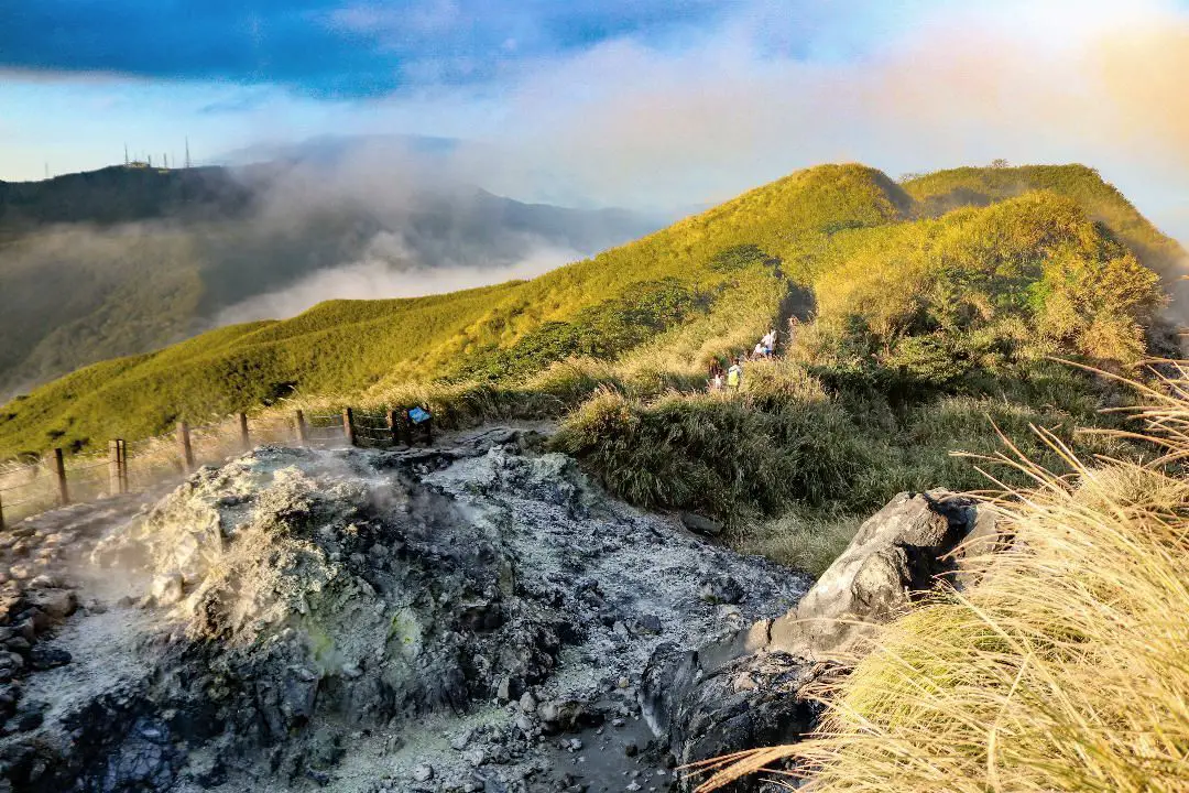
Yangmingshan National Park is a mountainous area in Taipei and New Taipei, known for its volcanic activity, hiking trails, wildlife, waterfalls, hot springs, and sulfur vents. It is definitely worth a stop on your trip to Taipei.
Historical Background: The area known as Yangmingshan now was formed by volcanoes about 700,000 years ago, forming many mountains about 1000 meters or less in northwestern Taiwan. The park still features active volcanoes, vents, and hot springs. The original name of the area was Caoshan (grass mountain 草山). During the Qing Dynasty, the area was used to harvest sulfur, and many of the hills were burned to help catch sulfur thieves, Qingtiangang likely being one of these areas. Sulfur mining was started in the Qing Dynasty by a British mining company that first obtained the rights to mine here in 1897. In 1927 during the Japanese era, Yangmingshan was made as the first national park in Taiwan, then known as Datunshan National Park Association. The area around Qingtiangang to Lengshuikeng was made into a ranch for water buffalo, and grass from Japan was planted here for them to graze. In 1950 after the ROC took Taiwan, Chiang Kai-shek renamed the park after the philosopher Wang Yangming, and called the area Yangmingshan. The KMT kept the ranch at Qingtiangang and continued to maintain it. They also built bunkers here and kept a garrison of troops. In 1985, after resolving many land disputes, Yangmingshan National Park was officially designated as a national park in the ROC era. Due to its easy accessibility from Taipei and many natural attractions, it is one of the most popular tourist destinations in Taipei City. Most visitors come on weekends, and it has parking lots and visitor's centers throughout the park. Hours: The visitor's centers are open from 9 AM to 4:30 PM. However you can visit the park 24/7. Price: Free entrance into the park (car parking 30-50 NT, scooter parking 20 NT) You can book tours to Yangmingshan on TripAdvisor here, Klook here, or KKday here or here. Tours: You can check out tours to Yangmingshan such as a One-day Yangmingshan NP Beitou Hot Spring Park and Tamsui Tour Package, Beitou and Yangmingshan Day Tour from Taipei, One Day Hike around Yangmingshan, or Private Yangmingshan Volcano Tour and more on TripAdvisor here, Klook here, or KKday here. When to Go: Silver Grass Season: Mang Grass season goes from September to November. During this time you will be able to see silvery grass all over the mountain tops around the park. Cherry Blossom Season: Cherry blossoms can be seen in the park from February to late March. Snowfall: Once every few years it can snow here from December to February. The snow usually only lasts a day or two and melts away quickly. Best Weather: In my opinion, the best weather is in the summer when constant rain makes the air cleaner, and summer mornings are usually clear. Be sure to start hiking in the morning for the best views and sunshine, as afternoon thundershowers are common. Hotels in Taipei: High end: We have stayed at and recommend the Yuanshan Grand Hotel, once the tallest building in Taiwan and still the most grand (book on Booking.com here, Tripadvisor here, or Agoda here). We have also stayed at and recommend the Grand Hyatt (book on Booking.com here, Tripadvisor here, Agoda here, or Hotels.com here), Marriot (book on Booking.com here, Tripadvisor here, Agoda here, or Hotels.com here), Sheraton (book on Booking.com here, Tripadvisor here, Agoda here, or Hotels.com here), Shangri-la (book on Booking.com here, Tripadvisor here, Agoda here, or Hotels.com here), and Regent (book on Booking.com here, Tripadvisor here, Agoda here, or Hotels.com here), which are all very high quality hotels in the middle of Taipei City. We also recommend Fullon Hotel which has locations in Tamsui and Fulong near the beach (book on Booking.com here, Tripadvisor here, Agoda here, or Hotels.com here). Budget Hotels: We have stayed at and also recommend Fu Chang Hotel in Ximending, which is within walking distance of Ximending shopping district (book on Booking.com here, Tripadvisor here, or Agoda here). We have also stayed at and recommend Hai Xia Your Home which is right in front of Fulong Beach (book on Booking.com here, Tripadvisor here, Agoda here, or Hotels.com here). Looking for a hotel? We recommend booking through Booking.com here, which provides the best quality selection of accommodation in Taiwan. Find out where to stay in our Taiwan hotels guide or search for the best hotel deals in Taiwan here. How to get there: By Car/Scooter: From Taipei, take provincial highway 2A north to the park, where you can see the main attractions such as Zhuzihu, Qixingshan, Datunshan, Qingtiangang, etc. There are many parking lots, but car parking is limited on weekends and the number of cars allowed up the mountain is also limited. There is also paid scooter parking. On weekends this place can be packed, and cars can be backed up for up to an hour or more, so consider taking a scooter or bus. Looking for scooter rental in Taipei? Check out Qeeq here, Klook here, or KKday here to search for options. You can also check out our scooter rental guide here. If you are looking for car rentals, you can also search Qeeq here, Klook here, or KKday here. You can also check out our car rental guide here. By Bus: From Beitou MRT Station, Take Little Bus 19 (小19), or another bus to the park. You can book tickets to travel to Taipei via inter-city bus on Klook here. You can book tickets to Taipei via high speed rail (HSR) on Klook here or KKDay here. By Bicycle: Cycling is the best way to enjoy Taiwan's landscapes if you have the time and energy. Looking for bicycle rentals in Taiwan? You can search on KKday here and search for tours on Klook here. You can also check out our Taiwan cycling guide here. Map: See below for a map of places mentioned in this blog: 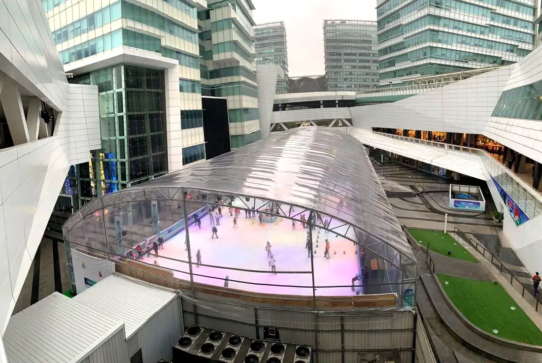
CTBC Financial Park’s Ice Rink in Nangang District of Taipei is Taiwan’s only outdoor skating rink. It also includes a man-made snow play area for people who have never experienced snow. It’s the perfect way to celebrate the holiday season, and the best part is it's free!
Background: The CTBC Financial Park is the headquarters of China Trust Commercial Bank, which was completed in 2013. The free outdoor ice rink at the China Trust Financial Center Park has been running since 2015, as a charitable way to give back to the community. The ice rink can get especially busy during holidays and weekends, so it is best to book online in advance if you have a group of 10 or more. Price: Free Skating Season: December to March every year (closed Chinese New Year's Eve) Session Times: Weekend Additional Session (Saturday and Sunday): 1:30 PM - 3:00 PM First Session: 3:30 - 5 PM Second Session: 5:30 - 7 PM Third Session: 7:30 - 9 PM Notes:
Website (Chinese only): https://www.ctbcfinancialpark.com/activity/Detail/102?category=2 Tours: You can book a tour of Taipei on Tripadvisor here, KKday here or Klook here. Where to stay: High end: We have stayed at and recommend the Nangang Marriott (book on Booking.com here or Agoda here). We have also stayed at and recommend the Yuanshan Grand Hotel, once the tallest building in Taiwan and still the most grand (book on Booking.com here or Agoda here). Looking for a hotel? We recommend booking through Booking.com here, which provides the best quality selection of accommodation in Taiwan. Find out where to stay in our Taiwan hotels guide or search for the best hotel deals in Taiwan here. Activities in Nangang: You can take 14% off the buffet at Courtyard Marriot Nangang on KKday here. You can also get a discount ticket to Crazy Car Café in Nangang, the only restaurant in Taiwan that offers Go-Karting, on KKday here. How to get there: By Car/Scooter: From Nangang Road at Nangang Exhibition Center MRT station, turn north toward CTBC Financial Park. There is paid parking on the south entrance. Looking for scooter rental in Taipei? You can search on Klook here or KKday here to search for options. You can also check out our scooter rental guide here. If you are looking for car rentals, you can also search Qeeq here, Klook here, or KKday here. You can also check out our car rental guide here. By Bus/MRT: Take the MRT to Nangang Software Park Station. The Ice rink is across the street. You can purchase a discount easy card to use on the MRT from Klook here or KKday here. You can also book an MRT travel pass on Klook here. By Bicycle: Cycling is the best way to enjoy Taiwan's landscapes if you have the time and energy. Looking for bicycle rentals in Taiwan? You can use Taiwan's many Youbike sharing stations, or search for rentals on KKday here, and search for tours on Klook here. You can also check out our Taiwan cycling guide here. You can also book a Sunset Riverside Bike Ride and Historical Tour, 4 Hour Cycling in Taipei, Ultimate 8-Hour Cycling City Tour, or Taipei City Bike Tour with Night Market Experience on TripAdvisor here. For more information, check out our Taiwan transportation guide here. Map: Please see below: 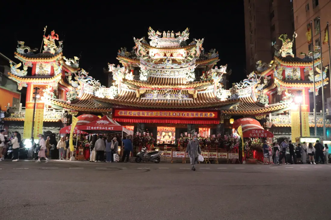
Sitting at the eastern entrance of Raohe Street Night market is the Ciyou temple, which is the religious center of the area. The temple is dedicated to the Goddess Matsu, with a blackened statue of her as the centerpiece. The temple was completed in 1753 and was also an important centerpiece of the old Xikou transportation area near Songshan Station.
Historical Background: Songshan Ciyou Temple was established in 1753 by a wondering monk who found fellow followers of Matsu in the area, after ten years of collecting donations. Starting in the Qing Dynasty, the area around Ciyou Temple and Songshan station was called Xikou (tin port), an important transportation hub in Taiwan (for more information about this old industrial area in East Taipei, check out our blog here). From Songshan station, goods from Taipei, Keelung, and Yilan could be directly loaded to the Keelung River and transported to the sea. However due to silting, the Keelung River became less and less import in terms of transportation, and the area around Raohe Street became obsolete, especially after the much wider Bade street was built right next to it. In order to help business in the area, the Taipei city government established a tourist night market on Raohe Street on May 11th, 1987, which was the second tourist night market established in Taipei. The temple has become the main religious center of the area, and is the main Matsu Temple in eastern Taipei. Price: Free! But don't you dare come with an empty wallet. Hours: 4 PM to 12 AM Tours: You can book a 2-hr Raohe Night Market Walking Private Tour with a Tour Guide, or Taipei at Night: Din Tai Fung Dinner & Raohe Street Night Market Guided Tour on TripAdvisor here, KKday here, or Klook here . Where to stay: High end: We have stayed at and recommend the Nangang Marriott (book on Booking.com here or Agoda here). We have also stayed at and recommend the Yuanshan Grand Hotel, once the tallest building in Taiwan and still the most grand (book on Booking.com here or Agoda here). Looking for a hotel? We recommend booking through Booking.com here, which provides the best quality selection of accommodation in Taiwan. Find out where to stay in our Taiwan hotels guide or search for the best hotel deals in Taiwan here. How to get there: By MRT: Take the MRT green line to Songshan station (the last station), and get out at exit 2, 3, or 4, and continue walking north for about 1 minute to Raohe street. You can also book an MRT travel pass on Klook here. By Train /TRA: Raohe Street is within walking distance of Songshan TRA station. Book tickets via the normal train (TRA) on Klook here. By Car: If you travel there by car, there is a parking garage on Bade street. If you are looking for car rentals, you can also search Qeeq here, Klook here, or KKday here. You can also check out our car rental guide here. By Scooter: There is scooter parking next to Songshan elementary school and on Songhe street in front of Rainbow bridge. Do not park on areas with a red line; this place is a hot spot for parking tickets, so beware. Looking for scooter rental in Taipei? You can search on Klook here or KKday here to search for options. You can also check out our scooter rental guide here. By Bicycle: Cycling is the best way to enjoy Taiwan's landscapes if you have the time and energy. Looking for bicycle rentals in Taiwan? You can use Taiwan's many Youbike sharing stations, or search for rentals on KKday here, and search for tours on Klook here. You can also check out our Taiwan cycling guide here. You can also book a Sunset Riverside Bike Ride and Historical Tour, 4 Hour Cycling in Taipei, Ultimate 8-Hour Cycling City Tour, or Taipei City Bike Tour with Night Market Experience on TripAdvisor here. For more information, check out our Taiwan transportation guide here. Map: 
Nangang's Bottle Cap Factory, now POPOP Taipei, was a Japanese era factory built 80 years ago and stopped production in 2004. Now it has been converted into a space for meetings, exhibitions, seminars, workshops, musical performances etc.
Background: Nangang's Bottle Cap Factory was built during the Japanese era in 1943, and continued operating until 2004, providing bottling parts for over 14 wine manufacturers. It was then abandoned until 2010 when Taipei City chose the spot for urban revitalization. The bottle cap factory renovation was completed in 2020. Currently there is space for meetings, exhibitions, seminars, workshops, musical performances, a night market, and more. On weekends it attracts hundreds of visitors especially when there are special events. Hours: 10 AM to 6 PM every day Price: Free Tours: You can book a tour of Taipei on Tripadvisor here, KKday here or Klook here. Where to stay: High end: We have stayed at and recommend the Nangang Marriott (book on Booking.com here or Agoda here). We have also stayed at and recommend the Yuanshan Grand Hotel, once the tallest building in Taiwan and still the most grand (book on Booking.com here or Agoda here). Looking for a hotel? We recommend booking through Booking.com here, which provides the best quality selection of accommodation in Taiwan. Find out where to stay in our Taiwan hotels guide or search for the best hotel deals in Taiwan here. How to get there: By Car/Scooter: Take Civic Boulevard or Nangang Road to Nangang Station. The bottle cap factory is just north of the station, across the street. There is paid parking at Nangang Station. Looking for scooter rental in Taipei? You can search on Klook here or KKday here to search for options. You can also check out our scooter rental guide here. If you are looking for car rentals, you can also search Qeeq here, Klook here, or KKday here. You can also check out our car rental guide here. By TRA/HSR/MRT: Take the TRA/HSR/MRT/inter-city bus to Nangang Station. The bottle cap factory is just north of the station, across the street. You can also book an MRT travel pass on Klook here. By Bicycle: Cycling is the best way to enjoy Taiwan's landscapes if you have the time and energy. Looking for bicycle rentals in Taiwan? You can use Taiwan's many Youbike sharing stations, or search for rentals on KKday here, and search for tours on Klook here. You can also check out our Taiwan cycling guide here. You can also book a Sunset Riverside Bike Ride and Historical Tour, 4 Hour Cycling in Taipei, Ultimate 8-Hour Cycling City Tour, or Taipei City Bike Tour with Night Market Experience on TripAdvisor here. For more information, check out our Taiwan transportation guide here. Map: Please see below: 
Dalong Street Night Market is a small night market in Taipei near the Taipei Confucius Temple and Dalongdong Baoan Temple. Here you can find local snacks and delicacies such as braised pork rice, fried chicken, and meatballs without huge crowds of people. It is definitely worth a trip if you are in the area.
Background: Dalong Street Night Market was formerly named Lanzhou Street Market (蘭州街夜市) before the street name was changed in 1975, which was a name given by the KMT to remember Lanzhou in Gansu Province of China. However when the road was improved in 1975 to better connect with Dalongdong Baoan Temple, the name was changed to Dalong Street. The street was an important route to Dadaocheng and many merchant shops were built here both during the Qing Dynasty and the Japanese era, and also many residences. Popular foods at this night market include braised pork rice, meatballs, salty crispy chicken, fried rice, etc., as well as some special "Confucian" cuisine because of the nearby Taipei Confucius Temple. The night market is usually not very busy and vehicle traffic is allowed to pass at all times. Hours: 4 PM to Midnight Price: Free Tours: You can book a tour of Taipei on Tripadvisor here, KKday here or Klook here. Hotels in Taipei: We have stayed at and recommend the Yuanshan Grand Hotel, once the tallest building in Taiwan and still the most grand (book on Booking.com here, Tripadvisor here, or Agoda here). We have stayed at and also recommend Fu Chang Hotel in Ximending, which is within walking distance of Ximending shopping district (book on Booking.com here, Tripadvisor here, or Agoda here). Looking for a hotel? We recommend booking through Booking.com here, which provides the best quality selection of accommodation in Taiwan. Find out where to stay in our Taiwan hotels guide or search for the best hotel deals in Taiwan here. Looking for Chinese lessons? You can get a 10% discount on Chinese lessons from Tutor ABC, the best Chinese language learning program out there by using the promo code FOREIGNERS10. How to get there: By MRT: The closest MRT station is Yuanshan Station, and is about a 5 minute walk. You can also book an MRT travel pass on Klook here. By Car/Scooter: Driving or taking a scooter there can be hard because there is limited paid parking nearby. Looking for scooter rental in Taipei? You can search on Klook here or KKday here to search for options. You can also check out our scooter rental guide here. If you are looking for car rentals, you can also search Qeeq here, Klook here, or KKday here. You can also check out our car rental guide here. By Bicycle: Cycling is the best way to enjoy Taiwan's landscapes if you have the time and energy. Looking for bicycle rentals in Taiwan? You can use Taiwan's many Youbike sharing stations, or search for rentals on KKday here, and search for tours on Klook here. You can also check out our Taiwan cycling guide here. You can also book a Sunset Riverside Bike Ride and Historical Tour, 4 Hour Cycling in Taipei, Ultimate 8-Hour Cycling City Tour, or Taipei City Bike Tour with Night Market Experience on TripAdvisor here. For more information, check out our Taiwan transportation guide here. Map: See below: 
Dalongdong Baoan Temple is a Taiwanese Folk Religion temple in Taipei dating back to the 1700s. After many repairs and renovations, it is one of the most intricate and beautiful temples in Taiwan, and is now one of the most popular places of worship for local residents. It is definitely worth a visit on your next trip to Taipei.
Background: The spot where Dalongdong Baoan Temple was built once had a wooden shrine that was built in 1742. The temple itself was built in about 1804. During the 1900s, the temple and surrounding grounds were expanded. The temple later fell into decay until 1985 when it underwent a major renovation thanks to the Taiwan government. The main deity worshipped here is Baosheng Dadi, a former doctor born during the Song Dynasty later worshipped as a deity, along with other gods. Even though Baoshend Dadi was a doctor, he is not worshipped to give good health. Instead he is worshipped as a protector. Historically, people prayed to him for safety during floods, droughts, invasions by thieves, and shipwrecks. The temple is a very popular place for worship especially on weekends. Hours: 6:30 AM to 9 PM every day. Price: Free Tours: You can book a tour of Taipei on Tripadvisor here, KKday here or Klook here. Hotels in Taipei: We have stayed at and recommend the Yuanshan Grand Hotel, once the tallest building in Taiwan and still the most grand (book on Booking.com here, Tripadvisor here, or Agoda here). We have stayed at and also recommend Fu Chang Hotel in Ximending, which is within walking distance of Ximending shopping district (book on Booking.com here, Tripadvisor here, or Agoda here). Looking for a hotel? We recommend booking through Booking.com here, which provides the best quality selection of accommodation in Taiwan. Find out where to stay in our Taiwan hotels guide or search for the best hotel deals in Taiwan here. Looking for Chinese lessons? You can get a 10% discount on Chinese lessons from Tutor ABC, the best Chinese language learning program out there by using the promo code FOREIGNERS10. How to get there: By MRT: The closest MRT station is Yuanshan Station, and is about a 5 minute walk. You can also book an MRT travel pass on Klook here. By Car/Scooter: Driving or taking a scooter there can be hard because there is limited paid parking nearby. Looking for scooter rental in Taipei? You can search on Klook here or KKday here to search for options. You can also check out our scooter rental guide here. If you are looking for car rentals, you can also search Qeeq here, Klook here, or KKday here. You can also check out our car rental guide here. By Bicycle: Cycling is the best way to enjoy Taiwan's landscapes if you have the time and energy. Looking for bicycle rentals in Taiwan? You can use Taiwan's many Youbike sharing stations, or search for rentals on KKday here, and search for tours on Klook here. You can also check out our Taiwan cycling guide here. You can also book a Sunset Riverside Bike Ride and Historical Tour, 4 Hour Cycling in Taipei, Ultimate 8-Hour Cycling City Tour, or Taipei City Bike Tour with Night Market Experience on TripAdvisor here. For more information, check out our Taiwan transportation guide here. Map: See below: 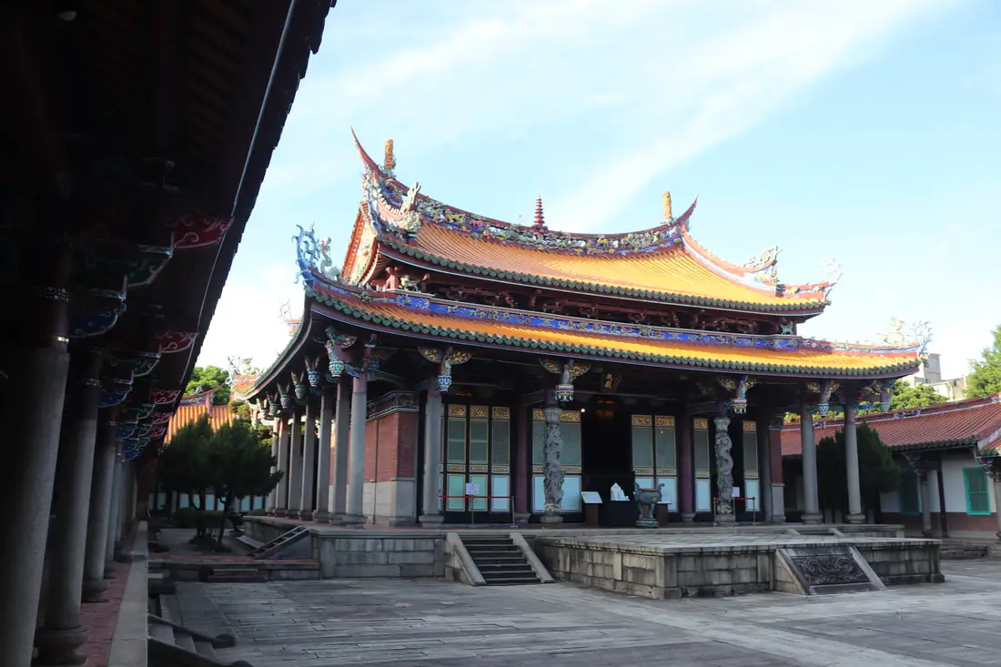
The Taipei Confucius Temple is one of the most beautiful and easily accessible Confucius temples in Taiwan. Dating back to the Qing Dynasty, it features traditional Chinese architecture similar to other Confucius temples in East Asia. It is open to the public and is within walking distance of the Yuanshan MRT Station. Also, it stays open until 9 PM at night. It is definitely worth a visit on your next trip to Taipei.
Background: The Taipei Confucius Temple was built during the Qing Dynasty in 1879 , not long after Taipeh Prefecture was created. In 1930, the temple was completely demolished by the Japanese, but was later rebuilt by local resident Wang Yishun. The Japanese continued to try to stamp out traditional Chinese culture, and Shinto rituals were performed at the new temple. After the KMT took control of Taiwan, the temple was used briefly as the headquarters of the Examination Yuan. Now the temple is a popular tourist destination especially thanks to its location near the MRT. Hours: 8:30 AM to 9 PM, closed Mondays Price: Free Tours: You can book a tour of Taipei on Tripadvisor here, KKday here or Klook here. Hotels in Taipei: We have stayed at and recommend the Yuanshan Grand Hotel, once the tallest building in Taiwan and still the most grand (book on Booking.com here, Tripadvisor here, or Agoda here). We have stayed at and also recommend Fu Chang Hotel in Ximending, which is within walking distance of Ximending shopping district (book on Booking.com here, Tripadvisor here, or Agoda here). Looking for a hotel? We recommend booking through Booking.com here, which provides the best quality selection of accommodation in Taiwan. Find out where to stay in our Taiwan hotels guide or search for the best hotel deals in Taiwan here. Looking for Chinese lessons? You can get a 10% discount on Chinese lessons from Tutor ABC, the best Chinese language learning program out there by using the promo code FOREIGNERS10. How to get there: By MRT: The closest MRT station is Yuanshan Station, and is about a 5 minute walk. You can also book an MRT travel pass on Klook here. By Car/Scooter: Driving or taking a scooter there can be hard because there is limited paid parking nearby. Looking for scooter rental in Taipei? You can search on Klook here or KKday here to search for options. You can also check out our scooter rental guide here. If you are looking for car rentals, you can also search Qeeq here, Klook here, or KKday here. You can also check out our car rental guide here. By Bicycle: Cycling is the best way to enjoy Taiwan's landscapes if you have the time and energy, however bikes are no allowed in the park. Looking for bicycle rentals in Taiwan? You can use Taiwan's many Youbike sharing stations, or search for rentals on KKday here, and search for tours on Klook here. You can also check out our Taiwan cycling guide here. You can also book a Sunset Riverside Bike Ride and Historical Tour, 4 Hour Cycling in Taipei, Ultimate 8-Hour Cycling City Tour, or Taipei City Bike Tour with Night Market Experience on TripAdvisor here. For more information, check out our Taiwan transportation guide here. Map: See below: 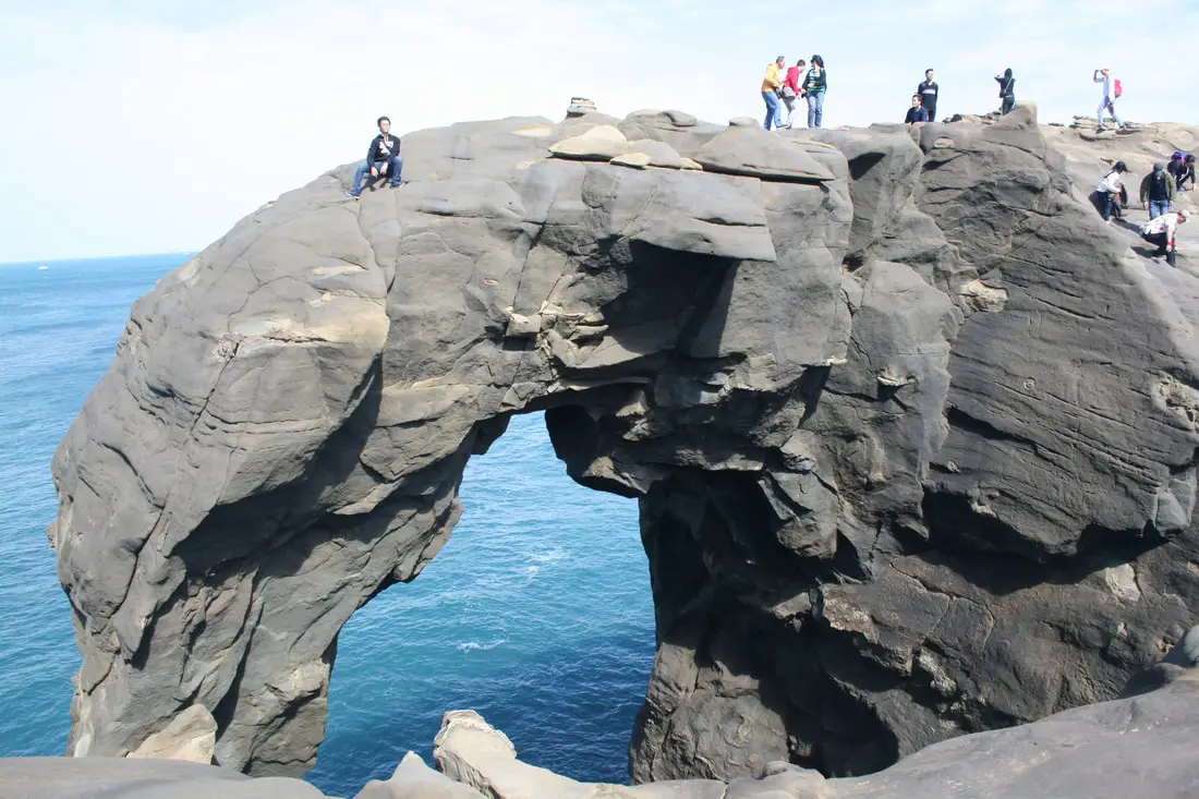
Elephant Trunk Rock was a rock shaped like its name in the Shenao area of Ruifang District, New Taipei City. There are also many interesting rock formations in the area. It was one of the most recognizable rock formations on the north coast and a popular location for, kayakers, snorkelers, and Instagrammers.
Elephant Trunk Rock eroded away and fell into the sea on December 16th, 2023. You can still visit for great views here, but the elephant trunk is gone. Background: The sandstone and sedimentary that forms the Elephant Rock formation was created between 10 and 20 million years ago, and was pushed out of the sea along with northern Taiwan thousands of years ago. The Elephant's head was formed by easily eroding sandstone, with the area under the trunk being eroded away by the sea and waves. Elephant Rock is so named because it looks like an elephant. The area around Elephant Rock was a protected military base until the year 2000, after which civilians were allowed to freely visit. Kayaking and Snorkeling are also popular activities near the Elephant Rock. Hours: 24/7 Price: Free Tours and Activities: At Elephant Rock there are many activities available to enjoy such as kayaking, canoeing, snorkeling, SUP / paddle boarding, water biking, and more activities which you can book on Klook here or KKday here. Hotels on Taiwan's Northern Coast: We recommend Fullon Hotel which has locations in Tamsui and Fulong near the beach (book on Booking.com here, Tripadvisor here, Agoda here, or Hotels.com here). We have stayed at and recommend Gold Mountain Ranch, which is a horse ranch and glamping destination in Jinshan. You can book a night at Gold Mountain Ranch on Klook here. You can also check out our full blog on the ranch here. We have also stayed at and recommend Hai Xia Your Home which is right in front of Fulong Beach (book on Booking.com here, Tripadvisor here, Agoda here, or Hotels.com here). Looking for a hotel? We recommend booking through Booking.com here, which provides the best quality selection of accommodation in Taiwan. Find out where to stay in our Taiwan hotels guide or search for the best hotel deals in Taiwan here. How to get there: By Car/Scooter: Drive to Keelung, then from downtown take provincial highway 2 east about 10 KM until you reach the Shenziao harbor, and there is some paid parking if you drive to the very end, which will put you closest to Elephant Trunk Rock. If you are looking for car rentals, you can also search Qeeq here, Klook here, or KKday here. You can also check out our car rental guide here. Looking for scooter rental in northern Taiwan? You can search on Klook here or KKday here to search for options. You can also check out our scooter rental guide here. By Train/Bus: Take the TRA to Badouzi (八斗子) station, then walk about 1 KM east until you reach the elephant rock on the coast. Book tickets via the normal train (TRA) on Klook here. You can purchase a discount easy card to use on the MRT and buses from Klook here or KKday here. You can also book an MRT travel pass on Klook here. By Bicycle: Cycling is the best way to enjoy Taiwan's landscapes if you have the time and energy. Looking for bicycle rentals in Taiwan? You can use Taiwan's many Youbike sharing stations, or search for rentals on KKday here, and search for tours on Klook here. You can also check out our Taiwan cycling guide here. You can also book a cycling tour on TripAdvisor here. For more information, check out our Taiwan transportation guide here. Map: Please see below: 
The Nanhai Academy is a collection of buildings built on a former Shinto shrine in traditional Chinese architecture not long after the KMT nationalists took control of Taiwan. The area consists of the National Art Education Center, National Music Education Center, Taipei Botanical Garden, and the National Museum of History. Located in downtown Taipei, it is easily accessible, and you can spend an entire afternoon here. It is definitely worth a visit on your next trip to Taipei.
Background: The buildings that make up the Nanhai Academy were originally built during the Japanese era (around 1900), and was known as Kenkou Shrine which was a Shinto shrine. Later the shrine was renovated to resemble Chinese classic style architecture not long after the KMT nationalists took control of Taiwan (around 1955) under order of Chiang Kai-shek. The area was used to establish the National Taiwan Science Education Center, National Taiwan Arts Education Center, National Taiwan Music Education Center, and Center for Educational Resources and Publishing. The area includes a theater, a performance hall, an auditorium, and a broadcasting building. Hours: 9:00 AM to 5 PM, closed Mondays Price: Free Tours: You can book a tour of Taipei on Tripadvisor here, KKday here or Klook here. Hotels in Taipei: We have stayed at and recommend the Yuanshan Grand Hotel, once the tallest building in Taiwan and still the most grand (book on Booking.com here, Tripadvisor here, or Agoda here). We have stayed at and also recommend Fu Chang Hotel in Ximending, which is within walking distance of Ximending shopping district (book on Booking.com here, Tripadvisor here, or Agoda here). Looking for a hotel? We recommend booking through Booking.com here, which provides the best quality selection of accommodation in Taiwan. Find out where to stay in our Taiwan hotels guide or search for the best hotel deals in Taiwan here. Looking for Chinese lessons? You can get a 10% discount on Chinese lessons from Tutor ABC, the best Chinese language learning program out there by using the promo code FOREIGNERS10. How to get there: By MRT: The closest MRT station is Xiaonanmen Station, and is about a 10 minute walk from the museum. You can also book an MRT travel pass on Klook here. By Car/Scooter: Driving or taking a scooter there can be hard because there is limited paid parking nearby. Looking for scooter rental in Taipei? You can search on Klook here or KKday here to search for options. You can also check out our scooter rental guide here. If you are looking for car rentals, you can also search Qeeq here, Klook here, or KKday here. You can also check out our car rental guide here. By Bicycle: Cycling is the best way to enjoy Taiwan's landscapes if you have the time and energy. Looking for bicycle rentals in Taiwan? You can use Taiwan's many Youbike sharing stations, or search for rentals on KKday here, and search for tours on Klook here. You can also check out our Taiwan cycling guide here. You can also book a Sunset Riverside Bike Ride and Historical Tour, 4 Hour Cycling in Taipei, Ultimate 8-Hour Cycling City Tour, or Taipei City Bike Tour with Night Market Experience on TripAdvisor here. For more information, check out our Taiwan transportation guide here. Map: See below: 
The Taipei Botanical Garden is a large area of trees, bushes, paths, and ponds, and one of the best places for birdwatching in downtown Taipei. It is also an area used for research, conservation, and education. Nearby you can also find the Nanhai Academy and National Museum of History. It is definitely worth a visit on your next trip to Taipei.
Background: The botanical garden was originally started in 1895 during the Japanese era to study local plants and was known as the Taipei Nursery, later the Taipei Experimental Forest, and finally the Botanical Garden. During WWII, the area was bombed and some palm trees still have scars from bombing raids. Later after the KMT took control of Taiwan, the garden was under the Forestry Bureau's jurisdiction, until 1999 when it was moved under the Agricultural Bureau. Currently, the garden is a popular spot for local residents. Hours: 9:00 AM to 5 PM, closed Mondays Price: Free Tours: You can book a tour of Taipei on Tripadvisor here, KKday here or Klook here. Hotels in Taipei: We have stayed at and recommend the Yuanshan Grand Hotel, once the tallest building in Taiwan and still the most grand (book on Booking.com here, Tripadvisor here, or Agoda here). We have stayed at and also recommend Fu Chang Hotel in Ximending, which is within walking distance of Ximending shopping district (book on Booking.com here, Tripadvisor here, or Agoda here). Looking for a hotel? We recommend booking through Booking.com here, which provides the best quality selection of accommodation in Taiwan. Find out where to stay in our Taiwan hotels guide or search for the best hotel deals in Taiwan here. How to get there: By MRT: The closest MRT station is Xiaonanmen Station, and is about a 10 minute walk from the museum. You can also book an MRT travel pass on Klook here. By Car/Scooter: Driving or taking a scooter there can be hard because there is limited paid parking nearby. Looking for scooter rental in Taipei? You can search on Klook here or KKday here to search for options. You can also check out our scooter rental guide here. If you are looking for car rentals, you can also search Qeeq here, Klook here, or KKday here. You can also check out our car rental guide here. By Bicycle: Cycling is the best way to enjoy Taiwan's landscapes if you have the time and energy, however bikes are no allowed in the park. Looking for bicycle rentals in Taiwan? You can use Taiwan's many Youbike sharing stations, or search for rentals on KKday here, and search for tours on Klook here. You can also check out our Taiwan cycling guide here. You can also book a Sunset Riverside Bike Ride and Historical Tour, 4 Hour Cycling in Taipei, Ultimate 8-Hour Cycling City Tour, or Taipei City Bike Tour with Night Market Experience on TripAdvisor here. For more information, check out our Taiwan transportation guide here. Map: See below: 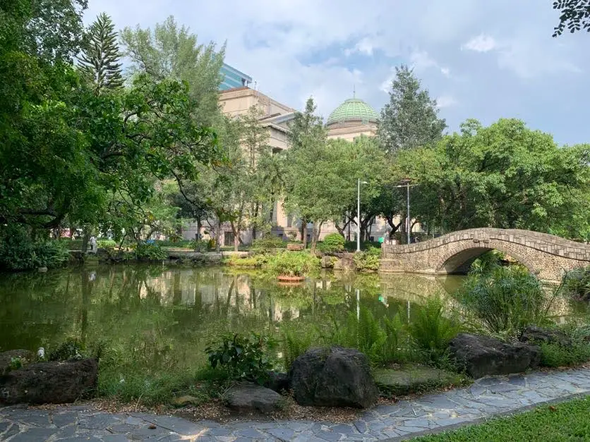
228 Peace Memorial Park is dedicated to the victims of the February 28 massacre of antigovernmental protestors not long after the KMT took control of Taiwan, and features a large memorial. The National Taiwan Museum also sits at the entrance to the park. Located in downtown Taipei, it is easily accessible, and you can spend an entire afternoon here. It is definitely worth a visit on your next trip to Taipei.
Background: What is now 228 Peace Memorial Park was established in 1900 by the Japanese as Taihoku New Park near the then Governer General's Office (currently the Taiwan Presidential Office). A radio station was also established on the premises, as well as National Taiwan Museum. The National Taiwan Museum was originally established in 1908 to commemorate the opening of the north-south railway in Taiwan and began with over 10,000 items related to Taiwan's academia, art, and industry. A Newer building was later built to house the collection in 1915. After the ROC took over Taiwan, it was known as the Taiwan Provincial Museum until 1999 when it changed its name to the National Taiwan Museum. It is the only museum established during the Japanese era that still stands today. The museum also underwent renovations in 2017. The museum has four areas: the main National Taiwan Museum (which is the focus of this blog), the Land Bank Exhibition Hall, Nanmen Park, and Railway Department Park. In the future, the Monopoly Bureau and the Mitsui Bussan Company Building will be added. After the KMT took over Taiwan, the park was renamed Taipei New Park. As part of the 228 antigovernmental protests, protesters took control of the radio station in the park and began to broadcast accusations against the KMT government. The radio station was taken back, and a brutal crackdown ensued. As part of the 228 incident, over 18,000 Taiwanese people were killed. As Taiwan moved toward democracy in the 1900's, the Taipei City Government renamed the park 228 Peace Memorial Park, and a memorial monument was placed inside the park. Now the park is a popular spot for recreation and exercise for local residents. Hours: 24/7 Price: Free National Taiwan Museum: 30 NT per person. You can book for a discount on Klook here or a museum combo ticket on KKday here. Tours: You can book a tour of Taipei on Tripadvisor here, KKday here or Klook here. Hotels in Taipei: We have stayed at and recommend the Yuanshan Grand Hotel, once the tallest building in Taiwan and still the most grand (book on Booking.com here, Tripadvisor here, or Agoda here). We have stayed at and also recommend Fu Chang Hotel in Ximending, which is within walking distance of Ximending shopping district (book on Booking.com here, Tripadvisor here, or Agoda here). Looking for a hotel? We recommend booking through Booking.com here, which provides the best quality selection of accommodation in Taiwan. Find out where to stay in our Taiwan hotels guide or search for the best hotel deals in Taiwan here. How to get there: By MRT: The closest MRT station is NTU Hospital Station, and is about a 5 minute walk from the museum. It is also about a ten minute walk from Taipei Main Station. You can also book an MRT travel pass on Klook here. By Car/Scooter: Driving or taking a scooter there can be hard because there is limited paid parking nearby. Looking for scooter rental in Taipei? You can search on Klook here or KKday here to search for options. You can also check out our scooter rental guide here. If you are looking for car rentals, you can also search Qeeq here, Klook here, or KKday here. You can also check out our car rental guide here. By Bicycle: Cycling is the best way to enjoy Taiwan's landscapes if you have the time and energy. Looking for bicycle rentals in Taiwan? You can use Taiwan's many Youbike sharing stations, or search for rentals on KKday here, and search for tours on Klook here. You can also check out our Taiwan cycling guide here. You can also book a Sunset Riverside Bike Ride and Historical Tour, 4 Hour Cycling in Taipei, Ultimate 8-Hour Cycling City Tour, or Taipei City Bike Tour with Night Market Experience on TripAdvisor here. For more information, check out our Taiwan transportation guide here. 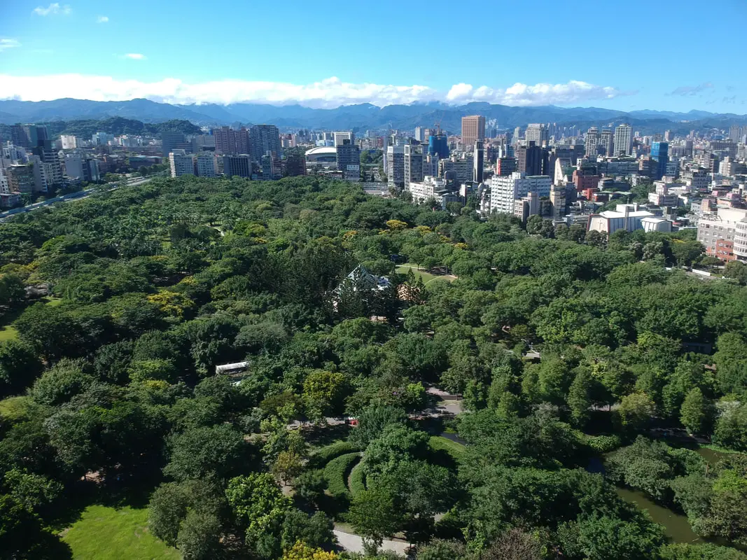
Daan Forest Park (aka Da'an Forest Park) is the most busy park in Taipei City. Built over a former military dependents village, it was meant to resemble Central Park in New York, and is considered the “lungs of Taipei.” You can also find lots of green space, ponds, and wildlife here. It is a great place to relax and connect with nature in the middle of the big city.
Background: The area where the park stands now was first designated as parkland in 1932 by the Japanese as part of their urban planning for the city of Taipei. After the ROC took control of Taiwan, there were many KMT military servicemen and their families who needed a place to stay, and the park served as a temporary place to build rudimentary housing for them. The military dependents villages built here were called Jianhua New Village (建華新村), Yuelu New Village (岳盧新村), and many other illegal structures built by Mainland Chinese people following the KMT to Taiwan. At its peak, the area housed a few thousand people comprising four neighborhoods. Plans to remake the land as a park began in 1956, but were delayed by debate about whether to remake the area as a forest park or have a recreational building. In 1989, it was finally decided to make a forest park. In 1992, the buildings on the land were demolished, and the park was opened to the public in 1994. The park can get very busy on weekends. Hours: 24/7 Price: Free Tours: You can book a Private Street Food Tour of Taipei on TripAdvisor here. For more information, you can check out Tripadvisor here, KKday here or Klook here, which are both great tour websites that can connect you with the right tour and tour guide for you. Hotels in Taipei: We have stayed at and recommend the Yuanshan Grand Hotel, once the tallest building in Taiwan and still the most grand (book on Booking.com here, Tripadvisor here, or Agoda here). We have stayed at and also recommend Fu Chang Hotel in Ximending, which is within walking distance of Ximending shopping district (book on Booking.com here, Tripadvisor here, or Agoda here). Looking for a hotel? We recommend booking through Booking.com here, which provides the best quality selection of accommodation in Taiwan. Find out where to stay in our Taiwan hotels guide or search for the best hotel deals in Taiwan here. How to get there: By MRT: Take the red line to Da'an Park MRT station. You can also book an MRT travel pass on Klook here. By Car/Scooter: There is limited paid parking on the north side of the park or across the street. Looking for scooter rental in Taipei? You can search on Klook here or KKday here to search for options. You can also check out our scooter rental guide here. If you are looking for car rentals, you can also search Qeeq here, Klook here, or KKday here. You can also check out our car rental guide here. By Bicycle: Cycling is allowed around the park but not inside. Cycling is the best way to enjoy Taiwan's landscapes if you have the time and energy. Looking for bicycle rentals in Taiwan? You can use Taiwan's many Youbike sharing stations, or search for rentals on KKday here, and search for tours on Klook here. You can also check out our Taiwan cycling guide here. You can also book a Sunset Riverside Bike Ride and Historical Tour, 4 Hour Cycling in Taipei, Ultimate 8-Hour Cycling City Tour, or Taipei City Bike Tour with Night Market Experience on TripAdvisor here. For more information, check out our Taiwan transportation guide here. Map: Please see below: 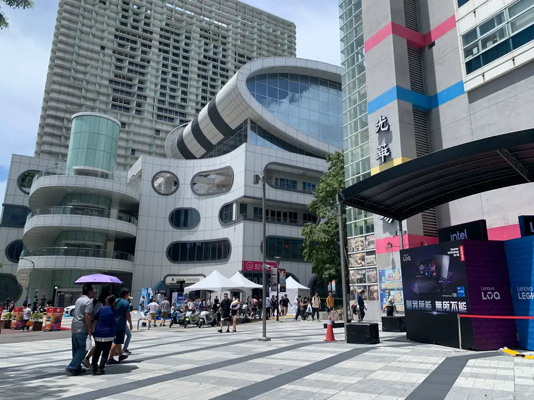
Guanghua Digital Plaza in Taipei is the Mecca for nerds and geeks looking for spare computer parts in Taiwan. The area around the plaza is also filled with countless other electronics stores. It is a one-stop shop for all your electronics needs.
Background: Guanghua Digital Plaza first started in 1973 under the old Guanghua Bridge which spanned the old railroad line in Taipei. During the time that Taipei's railroad was moved underground in 1992, Guanghua Digital Plaza also moved to an underground location on Bade Road, and then to a temporary building in 2006. on Civic Boulevard. By this time, many electronics shops had opened in the area. The main Guanghua Plaza building was completed in 2008, which has seven stories and over 196 vendors. Two other buildings were added to the plaza in 2018 and 2021, which added hotel rooms, offices, and restaurants. Currently, the area acts as a venue for the reveal of many new products from many big-name companies such as Acer, Asus, Microsoft, and Intel. This electronics market attracts thousands of visitors each day. Price: Free Hours: 11 AM to 9 PM every day Tours in Taipei: There are many tour itineraries that you can enjoy in Taipei that will take you to multiple destinations and arrange transportation. For more information, you can check out KKday here or Klook here which are both great tour websites that can connect you with the right tour and tour guide for you. Activities in Taipei: Indoor Skiing, Rock Climbing, Hiking, Wakeboarding, Surfing, Speedboat Surfing, SUP / Paddle Boarding, Diving, Snorkeling Kayaking, Canoeing, Water Biking, River Tracing / Canyoneering, ATVing, Horse Riding, Cooking Class, Archery, Ice Skating, Roller Skating, Tree Climbing, Urban Camping, Glamping, Motorcycling, Motorbike Tour, Dragon Boat Racing, Escape Room, Shen'ao Rail Bike, Laser Gun Experience, Batting Cages, Bowling, Paintball, Flight Simulation Experience, Taipei Tram Driving Experience, Rail Simulation Experience, Taipei 101 Observation Deck activity, Strawberry Picking, Professional Photo Shoot, Body Relaxation SPA, Night Tour, Calligraphy Workshop and more on Klook here or KKday here. Hotels in Taipei: We have stayed at and recommend the Yuanshan Grand Hotel, once the tallest building in Taiwan and still the most grand (book on Booking.com here, Agoda here, or Kayak here). We have stayed at and also recommend Fu Chang Hotel in Ximending, which is within walking distance of Ximending shopping district (book on Booking.com here, Agoda here, or Kayak here). Looking for a hotel? We recommend booking through Booking.com here, which provides the best quality selection of accommodation in Taiwan. Find out where to stay in our Taiwan hotels guide or search for the best hotel deals in Taiwan here. How to get there: By MRT: Take the green line MRT to Zhongxiao Xinsheng Station and the market is just a short walk away. You can also book an MRT travel pass on Klook here. By Car/Scooter: From central Taipei, take Civic Blvd. until you reach the plaza. It is hard to miss. There is paid parking nearby. If you are looking for car rentals, you can also search Qeeq here, Klook here, or KKday here. You can also check out our car rental guide here. Looking for scooter rental in Taipei? Click here or here to search for options. You can also check out our scooter rental guide here. By Bicycle: Cycling is the best way to enjoy Taiwan's landscapes if you have the time and energy. Looking for bicycle rentals in Taiwan? You can use Taiwan's many Youbike bike sharing stations, or search for rentals on KKday here, and search for tours on Klook here. You can also check out our Taiwan cycling guide here. For more information, check out our Taiwan transportation guide here. Map: Please see below: 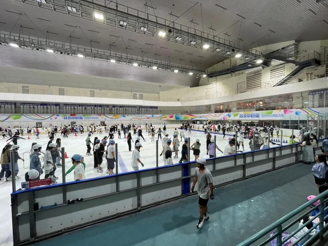
Taipei Arena is one of the few places in Taiwan that offers both ice skating and roller skating indoors all year round. For many people in Taiwan who have never seen snow, this is a unique experience and opportunity. It is definitely worth a trip during your next visit to Taipei.
Background: Taipei Arena was built over the former Taipei Baseball Stadium (1959-2000). Taipei Arena was completed in 2005 and is able to host many international sporting events such as ice skating, hockey, basketball, tennis, badminton, indoor soccer, concerts, and many other events. The arena is home to the Chinese Taipei Ice Hockey League. The place can get a little crowded during weekends and during summer and winter break, so come on weekdays during school times to avoid the crowds. Hours: 10 AM to 9 PM every day Price: Ice skating: Ice skating rink entrance: 200 NT per person (children under 6 are free) Ice skate rental: 80 NT per time for skates, and 20 NT per time for protective gear Roller Skating: 190 NT - 450 NT depending on the length of time. Discounts are given on weekdays. Tickets: You can book tickets for a discount on KKday here. Hotels in Taipei: We have stayed at and recommend the Yuanshan Grand Hotel, once the tallest building in Taiwan and still the most grand (book on Booking.com here, Agoda here, or Kayak here). We have stayed at and also recommend Fu Chang Hotel in Ximending, which is within walking distance of Ximending shopping district (book on Booking.com here, Agoda here, or Kayak here). Looking for a hotel? We recommend booking through Booking.com here, which provides the best quality selection of accommodation in Taiwan. Find out where to stay in our Taiwan hotels guide or search for the best hotel deals in Taiwan here. How to get there: By MRT: Take the green line MRT to Taipei Arena Station. You can also book an MRT travel pass on Klook here. By car/scooter: From central Taipei, take Nanjing East Road until you reach the arena. It is hard to miss. There is paid parking nearby. If you are looking for car rentals, you can also search Qeeq here, Klook here, or KKday here. You can also check out our car rental guide here. Looking for scooter rental in Taipei? Click here or here to search for options. You can also check out our scooter rental guide here. By Bicycle: Cycling is the best way to enjoy Taiwan's landscapes if you have the time and energy. Looking for bicycle rentals in Taiwan? You can use Taiwan's many Youbike bike sharing stations, or search for rentals on KKday here, and search for tours on Klook here. You can also check out our Taiwan cycling guide here. For more information, check out our Taiwan transportation guide here. Map: Please see below: 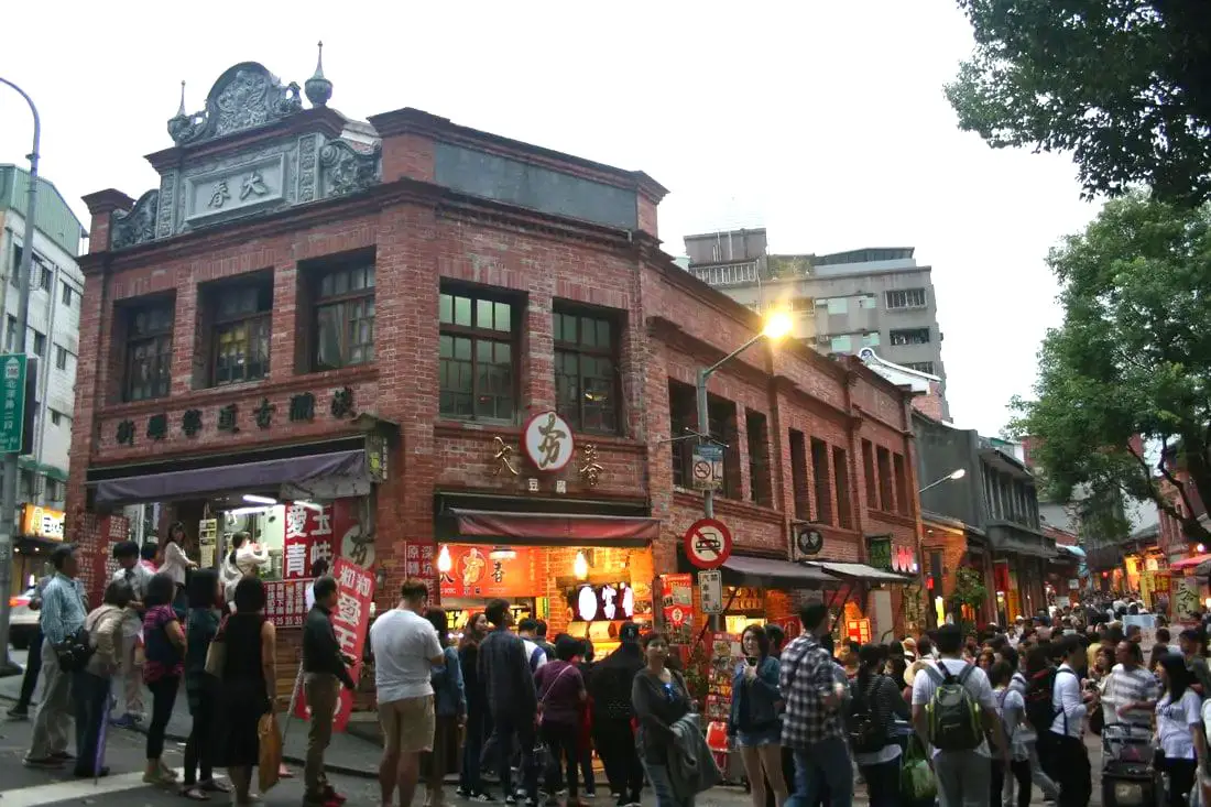
Taipei has some amazing old streets waiting to be discovered by you. Each one of the old streets around Taipei has a special story to tell that can help you understand more about Taiwan's History and Culture. In this guide, we will introduce the most popular old streets in Taipei, as well as some that are less well-known.
What is an "Old Street?" Taiwan's "old streets" can be difficult to define. There are technically "old streets" in every town in Taiwan, but what makes them famous enough to become known as the old street of the town? One can say that if there are enough historical buildings preserved in one spot, this can be considered an old street. However, sometimes old streets are put together by the local government and turned into a market or renovated historical area, or pedestrian area, with lots of stalls selling food and snacks and attracting lots of tourists. This is the kind of old street that most people want to visit, but we will cover both non-touristy old streets and touristy old streets in this blog. Brief Historical Background of Taipei: The land on which Taipei now stands on what was once part of Basay tribal land. The Basay people had lived on the land for thousands of years before the first Chinese settlers ever came. Chinese settlers from Fujian began living here during the Dutch rule in the 1600s. The first Chinese settlers came to the area in the mid-1800's during the Qing Dynasty. They created a public area for drying rice and grain, called Dadaocheng (大稻埕) which also became the central market in the area. The earliest trading shops were built in 1851, mainly selling rice, sugar, camphor, and tea. Dihua Street (迪化街) was created around this time, making it the oldest street in Taipei. Most of the buildings were one story and made of red brick in Fujian style, and later western style houses were built. The walls and gates of Taipei were completed in 1884. In 1891, the first train connecting Keelung and Taipei was completed. During the Japanese era, in 1904 the walls of Taipei were destroyed after less than 30 years, and Taipei was re-planned into the capital of Taiwan. After the ROC took control of Taiwan, Taipei continued as the capital city, as well as the financial hub of Taiwan. During the Taiwan miracle, many rural families moved from southern Taiwan to factories and offices in Taipei, making Taipei the most populous urban area in Taiwan. Currently, Taipei is the most advanced and affluent city in Taiwan. It also has Taiwan's most advanced public transportation system, making it easy for millions of commuters to live outside the city where rents are cheaper. Now, most of Taiwan's economic activity is based in this city. Basic Taipei Travel Tips:
When should you go to Taipei? In my opinion, the best weather in Taipei is from March-May, and October - November, when the temperatures stay around 26 degrees Celsius and there is not as much rain. Summers are also nice, with the most sunny weather, but also hot and rainy. Winters can be cold (but not below freezing) and usually wet. Overall, there is no wrong answer as to what time of year you should visit Taipei. You will have a great time here at any time of year. Hotels in Taipei: We have stayed at and recommend the Yuanshan Grand Hotel, once the tallest building in Taiwan and still the most grand (book on Booking.com here, Agoda here, or Kayak here). We have stayed at and also recommend Fu Chang Hotel in Ximending, which is within walking distance of Ximending shopping district (book on Booking.com here, Agoda here, or Kayak here). Looking for a hotel? We recommend booking through Booking.com here, which provides the best quality selection of accommodation in Taiwan. Find out where to stay in our Taiwan hotels guide or search for the best hotel deals in Taiwan here. Tours in Taipei: There are many tour itineraries that you can enjoy in Taipei that will take you to multiple destinations and arrange transportation. For more information, you can check out KKday here or Klook here which are both great tour websites that can connect you with the right tour and tour guide for you. Attractions in Taipei: There are many attractions that you can enjoy in Taipei such as Taipei 101 Observatory, Taipei 101 460 Skyline Observatory, Taipei Children's Amusement Park, Maokong Gondola, National Palace Museum, Yehliu Ocean World, Yehliu Geopark, National Museum of Marine Science and Biology, i-ride 5D cinema, Astronomical Museum, Miniatures Museum of Taiwan, Double Decker Sightseeing Bus, Miramar Ferris Wheel Ticket, Taipei Zoo, Heping Island Park, Ju Ming Museum, Yuanshan Hotel Secret Road, National Taiwan Museum, New Taipei Gold Museum, Futian Leisure Farm, Chiang Kai-shek Shilin Residence, Chi Po-lin Museaum, Beitou Museum, Tsao Wonderland, Railway Museum, Fort San Domingo, 13 Levels Archaeology Museum, Austin Land, Museum of World Religions, Formosan Aboriginies Museum, ASE Parent-child Park, teamLab Future Park, Yukids Island, VR Experience, Bat Cave, Neidong Waterfall, Candlestick Islet, Jurassic Snow Park, Zhonghe High5 Amusement Park, Longshan Temple, Xingtian Temple, Ningxia Night Market, Yansan Night Market, Meteor Garden, Yingge Old Street, and many more attractions on Klook here or KKday here. Activities in Taipei: Indoor Skiing, Rock Climbing, Hiking, Wakeboarding, Surfing, Speedboat Surfing, SUP / Paddle Boarding, Diving, Snorkeling Kayaking, Canoeing, Water Biking, River Tracing / Canyoneering, ATVing, Horse Riding, Cooking Class, Archery, Ice Skating, Roller Skating, Tree Climbing, Urban Camping, Glamping, Motorcycling, Motorbike Tour, Dragon Boat Racing, Escape Room, Shen'ao Rail Bike, Laser Gun Experience, Batting Cages, Bowling, Paintball, Flight Simulation Experience, Taipei Tram Driving Experience, Rail Simulation Experience, Taipei 101 Observation Deck activity, Strawberry Picking, Professional Photo Shoot, Body Relaxation SPA, Night Tour, Calligraphy Workshop and more on Klook here or KKday here. Just to let you know, if you book using the links above, we get some commission at no cost to you, and you can help support our blog. Some of the Klook links may not work if you are using an Ad blocker. You can click here to receive $5 USD on your first Klook purchase. How to get there: The only way to get to Taiwan is via airplane. Planes leave daily from Taipei's Songshan and Toayuan Airport. Taoyuan Airport: Taoyuan is Taiwan's largest airport and typically has cheaper flights and more flight times to choose from. It's about an hour's journey from Taoyuan Airport to the center of Taipei. You can travel via MRT, HSR, bus, or taxi to get to Taipei. You can get 30% off the Taoyuan Airport VIP lounge on KKday here. Songshan Airport: Songshan is a small airport in Taipei's city center, and can be a convenient option for people traveling within Asia. The airport is right on the Taipei MRT brown line. You can book cheap flights to Taiwan on KKday here, Trip.com here, CheapO Air here, or Kiwi here. How to get around in Taipei: Taipei's transportation system is convenient and safe. There are many options you can consider to get around in Taipei below: By Train: Gets you to the city center of all major cities in Taiwan. It is about 800NT to get from Taipei to Kaohsiung. Roughly half the price of the HSR. Book tickets via the normal train (TRA) on Klook here. By HSR: (High-Speed Rail) – Gets you quickly from north to south. Besides Taipei and Kaohsiung, most of the stations are far from city centers. It costs about 1500NT to get from Taipei to Kaohsiung. You can book tickets to the high-speed rail (HSR) on Klook here or KKDay here. By MRT: (Mass Rapid Transit, Metro train, subway) – Easily gets you around Taipei and Kaohsiung. You can also book an MRT travel pass on Klook here. By Bus: Buses can be tricky. Long-range buses such as Ubus and King Bus are easier to understand and cheaper than the local train. They can take you to the city center of every city throughout Taiwan and to remote tourist destinations such as sun moon lake. A long-range bus from Taipei to Kaohsiung is about 500 NT. You can also book tickets to travel to Shifen via inter-city bus on Klook here. By Taxi: You can take short rides for about 150 NT, or hire a Taxi for a day for around 150 USD. By Car: If you are looking for car rentals, you can also search Qeeq here, Klook here, or KKday here. You can also check out our car rental guide here. By Scooter: Looking for scooter rental in Taipei? Click here or here to search for options. You can also check out our scooter rental guide here. By Bicycle: Cycling is the best way to enjoy Taiwan's landscapes if you have the time and energy. Looking for bicycle rentals in Taiwan? You can use Taiwan's many Youbike bike sharing stations, or search for rentals on KKday here, and search for tours on Klook here. You can also check out our Taiwan cycling guide here. For more information, check out our Taiwan transportation guide here. Tourist Site Map: Check out our map below of tourist sites in Taiwan, which is constantly updated: 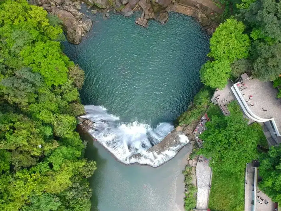
Taipei is home to some of Taiwan's most magnificent waterfalls, and most of them are just a short trip away. Here we have compiled a list of the most easily accessible waterfalls around Taipei.
Please note this is not an exhaustive list. There are many more waterfalls in Taipei than are listed in this blog. Get out there and discover Taipei's waterfalls for yourself! Safety Tips When Visiting Waterfalls:
Basic Taipei Travel Tips:
When should you go to Taipei? In my opinion, the best weather in Taipei is from March-May, and October - November, when the temperatures stay around 26 degrees Celsius and there is not as much rain. Summers are also nice, with the most sunny weather, but also hot and rainy. Winters can be cold (but not below freezing) and usually wet. Overall, there is no wrong answer as to what time of year you should visit Taipei. You will have a great time here at any time of year. Hotels in Taipei: We have stayed at and recommend the Yuanshan Grand Hotel, once the tallest building in Taiwan and still the most grand (book on Booking.com here, Agoda here, or Kayak here). We also recommend Fullon Hotel which has locations in Tamsui and Fulong near the beach (book on Booking.com here, Agoda here, or Kayak here). Budget Hotels: We have stayed at and also recommend Fu Chang Hotel in Ximending, which is within walking distance of Ximending shopping district (book on Booking.com here, Agoda here, or Kayak here). We have also stayed at and recommend Hai Xia Your Home which is right in front of Fulong Beach (book on Booking.com here, Agoda here, or Kayak here). Looking for a hotel? We recommend booking through Booking.com here, which provides the best quality selection of accommodation in Taiwan. Find out where to stay in our Taiwan hotels guide or search for the best hotel deals in Taiwan here. Tours in Taipei: There are many tour itineraries that you can enjoy in Taipei that will take you to multiple destinations and arrange transportation. For more information, you can check out KKday here or Klook here. Attractions in Taipei: There are many attractions that you can enjoy in Taipei such as Taipei 101 Observatory, Taipei 101 460 Skyline Observatory, Taipei Children's Amusement Park, Maokong Gondola, National Palace Museum and many more attractions on Klook here or KKday here. Activities in Taipei: You can also look for more activities in Taipei such as Rock Climbing, Surfing, Speedboat Surfing, Diving, Snorkeling, Cooking Class, Glamping, Motorcycling, and more on Klook here or KKday here. Just to let you know, if you book using the links above, we get some commission at no cost to you, and you can help support our blog. Some of the Klook links may not work if you are using an Ad blocker. You can click here to receive $5 USD on your first Klook purchase. How to get there: The only way to get to Taiwan is via airplane. Planes leave daily from Taipei's Songshan and Toayuan Airport. Taoyuan Airport: Taoyuan is Taiwan's largest airport and typically has cheaper flights and more flight times to choose from. It's about an hour's journey from Taoyuan Airport to the center of Taipei. You can travel via MRT, HSR, bus, or taxi to get to Taipei. You can get 30% off the Taoyuan Airport VIP lounge on KKday here. Songshan Airport: Songshan is a small airport in Taipei's city center, and can be a convenient option for people traveling within Asia. The airport is right on the Taipei MRT brown line. You can book cheap flights to Taiwan on KKday here, Trip.com here, CheapO Air here, or Kiwi here. How to get around in Taipei: Taipei's transportation system is convenient and safe. There are many options you can consider to get around in Taipei below: By Train: Gets you to the city center of all major cities in Taiwan. It is about 800NT to get from Taipei to Kaohsiung. Roughly half the price of the HSR. Book tickets via the normal train (TRA) on Klook here. By HSR: (High-Speed Rail) – Gets you quickly from north to south. Besides Taipei and Kaohsiung, most of the stations are far from city centers. It costs about 1500NT to get from Taipei to Kaohsiung. You can book tickets to the high-speed rail (HSR) on Klook here or KKDay here. By MRT: (Mass Rapid Transit, Metro train, subway) – Easily gets you around Taipei and Kaohsiung. You can also book an MRT travel pass on Klook here. By Bus: Buses can be tricky. Long-range buses such as Ubus and King Bus are easier to understand and cheaper than the local train. They can take you to the city center of every city throughout Taiwan and to remote tourist destinations such as sun moon lake. A long-range bus from Taipei to Kaohsiung is about 500 NT. You can also book tickets to travel to Shifen via inter-city bus on Klook here. By Taxi: You can take short rides for about 150 NT, or hire a Taxi for a day for around 150 USD. By Car: If you are looking for car rentals, you can also search Qeeq here, Klook here, or KKday here. You can also check out our car rental guide here. By Scooter: Looking for scooter rental in Taipei? Click here or here to search for options. You can also check out our scooter rental guide here. By Bicycle: Cycling is the best way to enjoy Taiwan's landscapes if you have the time and energy. Looking for bicycle rentals in Taiwan? You can use Taiwan's many Youbike bike sharing stations, or search for rentals on KKday here, and search for tours on Klook here. You can also check out our Taiwan cycling guide here. For more information, check out our Taiwan transportation guide here. Tourist Site Map: Check out our map below of tourist sites in Taiwan, which is constantly updated: 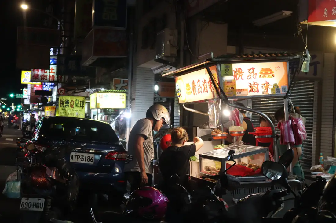
Yansan Night Market (aka Yuan Sen Night Market, or Daqiaotou Night Market, or Yanping Tourist Night Market) is a small night market in Datong District of Taipei. The night market is not fancy, not touristy, and not very busy. It caters local snacks to local people. It also has three shops that were mentioned in the Michelin guide to Taiwan.
Background: Yansan Night Market was originally called Daqiaotou Night Market (literally Big Bridge Head Night Market), because it sits at the head of the Taipei Bridge, on either side of Yanping North Road. Many of the stalls on this road have been operating for nearly 40 years. The night market is very close to Dadaocheng, which had settlements here dating back to the Dutch rule in the 1600s. The first Chinese settlers came to the area in the mid-1800's during the Qing Dynasty. They created a public area for drying rice and grain, called Dadaocheng (大稻埕) from which the place got its name, which also became the central market in the area. The earliest trading shops were built in 1851, mainly selling rice, sugar, camphor, and tea. Dihua Street (迪化街), or Center Street (中街) was created around this time, making it the oldest street in Taipei. In 2019, the Michelin Guide honored YanSan night market by mentioning three of the eateries here: Taiwanese cabbage rice and pork rib soup, DaQiaoTou Tube Rice Pudding, and Shih Chia Big Rice Balls. Hours: Every day from 5 PM to 9 PM Price: Free Tours: You can book a Michelin food tour of Yansan Night Market and nearby locations on Klook here. Hotels in Taipei: We have stayed at and recommend the Yuanshan Grand Hotel, once the tallest building in Taiwan and still the most grand (book on Booking.com here, Agoda here, or Kayak here). We also recommend Fullon Hotel which has locations in Tamsui and Fulong near the beach (book on Booking.com here, Agoda here, or Kayak here). Budget Hotels: We have stayed at and also recommend Fu Chang Hotel in Ximending, which is within walking distance of Ximending shopping district (book on Booking.com here, Agoda here, or Kayak here). We have also stayed at and recommend Hai Xia Your Home which is right in front of Fulong Beach (book on Booking.com here, Agoda here, or Kayak here). Looking for a hotel? We recommend booking through Booking.com here, which provides the best quality selection of accommodation in Taiwan. Find out where to stay in our Taiwan hotels guide or search for the best hotel deals in Taiwan here. How to get there: By MRT: The night market is right in front of Daqiaotou MRT station on the orange line. You can also book an MRT travel pass on Klook here. By Scooter: Take Minquan West Road west until you reach the Taipei Bridge, then turn right onto Yanping North Road. There is limited parking on the side of the road. Looking for scooter rental in Taipei? You can search on Klook here or KKday here to search for options. You can also check out our scooter rental guide here. By Car: Take Minquan West Road west until you reach the Taipei Bridge, then turn right onto Yanping North Road. There are some paid parking garages around the night market. If you are looking for car rentals, you can also search Qeeq here, Klook here, or KKday here. You can also check out our car rental guide here. By Bicycle: Cycling is the best way to enjoy Taiwan's landscapes if you have the time and energy. Looking for bicycle rentals in Taiwan? You can use Taiwan's many Youbike sharing stations, or search for rentals on KKday here, and search for tours on Klook here. You can also check out our Taiwan cycling guide here. You can also book a Sunset Riverside Bike Ride and Historical Tour, 4 Hour Cycling in Taipei, Ultimate 8-Hour Cycling City Tour, or Taipei City Bike Tour with Night Market Experience on TripAdvisor here. For more information, check out our Taiwan transportation guide here. Map: Please see below: 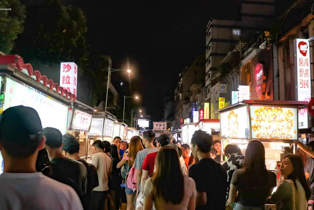
Ningxia Night Market is one of the most popular night markets in Taipei. The night market takes up two city blocks and includes food stalls as well as sit-down areas and restaurants. Popular delicacies here include Oyster Omelet, fried chicken, fried squid, and much more. The night market is also very close to the Dadaocheng historical area and is often considered to be a part of it. It is definitely worth a stop on your next trip to Taipei.
Historical Background: Ningxia Night Market began as a few food stalls on on the Jiancheng Roundabout (建成圓環) on Chongqing North Road, not long after the Danshui Railway Line was built in 1908. It was the most popular night market in Taipei during the Japanese Era. After the ROC took control of Taiwan, it continued to be a popular night market known for great food and cheap prices. After Chongqing North Road was widened in 1973, most of the stalls moved north to either side of Ningxia Road. Ningxia Road was refurbished in 2006 making it more sanitary and environmentally friendly. In 2015, it was named the best night market for shopping, the friendliest night market, the most charismatic night market, the most environmentally conscious night market, and the best-tasting night market in Taipei. As for the roundabout, the local government saw it as a run-down area with lots of illegal stalls. There were also two large fires there in 1993 and 1998. In 2002, then Taipei Mayor Ma Yingjeou tore down the old roundabout and built a glass restaurant area in its place. However, restaurant owners found that the new building was poorly designed and bad for business, and the popular restaurants moved out. Later on, in 2008 the area was rebuilt again, but there was a scandal involving how the area was rented, and so the area shut down in 2011. In 2016, the roundabout was made into a park. Hours: Open from 5 PM until 1 AM, every night. Tours: You can book a food tour of Ningxia Night Market on Klook here or TripAdvisor here. Hotels in Taipei: We have stayed at and recommend the Yuanshan Grand Hotel, once the tallest building in Taiwan and still the most grand (book on Booking.com here or Agoda here). We also recommend Fullon Hotel which has locations in Tamsui and Fulong near the beach (book on Booking.com here or Agoda here). Budget Hotels: We have stayed at and also recommend Fu Chang Hotel in Ximending, which is within walking distance of Ximending shopping district (book on Booking.com here or Agoda here). We have also stayed at and recommend Hai Xia Your Home which is right in front of Fulong Beach (book on Booking.com here or Agoda here). Looking for a hotel? We recommend booking through Booking.com here, which provides the best quality selection of accommodation in Taiwan. Find out where to stay in our Taiwan hotels guide or search for the best hotel deals in Taiwan here. How to get there: By MRT: Take the Red Line to Shuanglian Station and then take exit 1 or 2 west out of the station. The night market is about two blocks down the road. You can also book an MRT travel pass on Klook here. By Scooter: Take Chongqing North Road in central Taipei until you reach Ningxia Road. You can park on the side of the road near Ningxia Road. Looking for scooter rental in Taipei? You can search on Klook here or KKday here to search for options. You can also check out our scooter rental guide here. By Car: Take Chongqing North Road in central Taipei until you reach Ningxia Road. You can park on the side of the road near Ningxia Road. There are some paid parking garages around the night market. If you are looking for car rentals, you can also search Qeeq here, Klook here, or KKday here. You can also check out our car rental guide here. By Bicycle: Cycling is the best way to enjoy Taiwan's landscapes if you have the time and energy. Looking for bicycle rentals in Taiwan? You can use Taiwan's many Youbike sharing stations, or search for rentals on KKday here, and search for tours on Klook here. You can also check out our Taiwan cycling guide here. You can also book a Sunset Riverside Bike Ride and Historical Tour, 4 Hour Cycling in Taipei, Ultimate 8-Hour Cycling City Tour, or Taipei City Bike Tour with Night Market Experience on TripAdvisor here. For more information, check out our Taiwan transportation guide here. Map: See below: 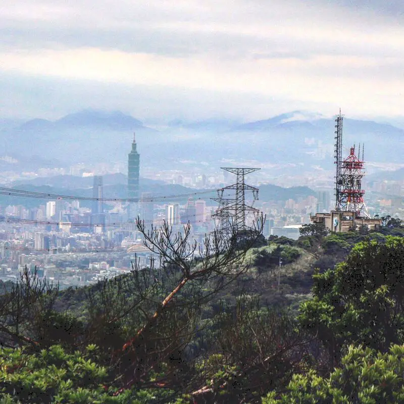
Wuzhishan is a beautiful mountain in Xizhi District of New Taipei. It is a popular place to stop for hikers, bikers, and Instagrammers due to its amazing views of east Taipei. Also there are many coffee shops here with amazing views. Besides taking photos, Wuzhishan is a great place to relax and enjoy nature.
Background: The rock formations that form Wuzhishan formed as sediment under the ocean millions of years ago, and was later uplifted thanks to the collision of the Eurasian and Philippine plates. The rocks are mainly sedimentary and are part of the same formation that forms the special rock formations on the northern coast around Keelung, and the waterfalls in Pingxi. Wuzhishan sits at 376 meters above sea level, while the bottom of the mountain is 76 meters, and the road it is 2.1 KM, making it a short, steep climb. Dream Lake get's its name from the thick fog that covers it during winter months, making it look like a dreamscape. Dream Lake is a popular spot for couples, wedding photography, and Instagram photos. Hours: 24/7 Price: Free Hike Difficulty: Moderate: About a two hour hike round trip, steep and difficult climbing through the forest with aid of ropes. Tours in Taipei: There are many tour itineraries that you can enjoy in Taipei that will take you to multiple destinations and arrange transportation. For more information, you can check out Tripadvisor here, KKday here or Klook here, which are both great tour websites that can connect you with the right tour and tour guide for you. Activities in Taipei: You can also look for more activities in Taipei such as Rock Climbing, Surfing, Speedboat Surfing, Diving, Snorkeling, Cooking Class, Glamping, Motorcycling, and more on Klook here or KKday here. Hotels in Taipei: We have stayed at and recommend the Yuanshan Grand Hotel, once the tallest building in Taiwan and still the most grand (book on Booking.com here, Tripadvisor here, or Agoda here). We have stayed at and also recommend Fu Chang Hotel in Ximending, which is within walking distance of Ximending shopping district (book on Booking.com here, Tripadvisor here, or Agoda here). Looking for a hotel? We recommend booking through Booking.com here, which provides the best quality selection of accommodation in Taiwan. Find out where to stay in our Taiwan hotels guide or search for the best hotel deals in Taiwan here. How to get there: By Car/Scooter: Take Xiwan Road (夕萬路) all the way to the top. You can also hike it starting from the Wuzhishan Old Trail trailhead. Looking for scooter rental in Taipei? You can search on Klook here or KKday here to search for options. You can also check out our scooter rental guide here. If you are looking for car rentals, you can also search Qeeq here, Klook here, or KKday here. You can also check out our car rental guide here. By Bus: Take Dongnan Bus F910 from Xizhi Park about 40 minutes up the mountain to Wuzhishan. You can purchase a discount easy card to use on the MRT from Klook here or KKday here. You can also book an MRT travel pass on Klook here. By Bicycle: Cycling is the best way to enjoy Taiwan's landscapes if you have the time and energy. Looking for bicycle rentals in Taiwan? You can use Taiwan's many Youbike sharing stations, or search for rentals on KKday here, and search for tours on Klook here. You can also check out our Taiwan cycling guide here. ​You can also book a Sunset Riverside Bike Ride and Historical Tour, 4 Hour Cycling in Taipei, Ultimate 8-Hour Cycling City Tour, or Taipei City Bike Tour with Night Market Experience on TripAdvisor here. For more information, check out our Taiwan transportation guide here. Map: Please see below: |
Author 作家I am an American expat who has extensive experience living, working, and traveling in Taiwan. In my day, I had to learn many things about Taiwan the hard way. But I have come to learn that Taiwan is one of the best places in the world for Foreigners to live. This blog does not represent the opinions of every foreigner in Taiwan. I am just trying to help others learn more about this beautiful country. Tutor ABC - World's No. 1 Online Platform for learning English and Chinese. Get 10% off all Tutor ABC website listed prices with promo code: FOREIGNERS10 Tutor ABC - 世界第一英語和中文線上學習平台 使用促銷代碼: FOREIGNERS10 可享有 Tutor ABC 網站上列出的所有價格 10% 的折扣 Archives 檔案
April 2024
Tutor ABC - World's No. 1 Online Platform for learning English and Chinese. Get 10% off all Tutor ABC website listed prices with promo code: FOREIGNERS10 Tutor ABC - 世界第一英語和中文線上學習平台 使用促銷代碼: FOREIGNERS10 可享有 Tutor ABC 網站上列出的所有價格 10% 的折扣 Categories
|
 RSS Feed
