
Taiwan is the most friendly country in the world for foreigners, and one of the best tourist destinations in the world. Many have called it the best kept secret in Asia. Taiwan is not usually known as a travel destination, mainly because of PRC China that tries to downplay its existence, and the fact that the Taiwan Tourism Bureau does not do a very good job. We will try to make up for that with this blog.
0 Comments
Pingtung is Taiwan's southernmost county and includes the best beaches, the best outer island, some of the best mountains, rivers, and waterfalls, and also interesting historical and cultural sites. It should definitely be on your list on your next visit to Taiwan.
When to go: Pingtung is great year round, but it can get a little hot in the summer, and Typhoon season and the heavy rain season last from about May to October. If you are afraid of the heat and rain then you can visit during winter when the temperatures are mild and the climate is dryer. Winters are windy and colder, but the water is still warm enough to swim in. Winter is a better time for activities like hiking and surfing. How to get there: By Car/Scooter: Take Provincial Highway 1 south to the bottom of Taiwan until it becomes Pingtung, or if in a car you can take National Freeway 3. Looking for scooter rental in Pingtung? Click here or here to search for options. If you are looking for car rentals, you can also search Qeeq here, Klook here, or KKday here. You can also check out our car rental guide here. By Bicycle: Cycling is the best way to enjoy Taiwan's landscapes if you have the time and energy. Looking for bicycle rentals in Taiwan? You can search on KKday here and search for tours on Klook here. You can also check out our Taiwan cycling guide here. By Bus: You can book tickets to travel to Pingtung via inter-city bus on Klook here. By TRA Train: There are many TRA stations in Pingtung which makes this a convenient option. You can book tickets to Pingtung via high speed rail (HSR) on Klook here or KKDay here, or book tickets via the normal train (TRA) on Klook here. By Plane: There are direct shuttle buses to Pintung from Kaohsing's Xiaogang (KHH) Airport. You can search for cheap flights in Taiwan here. Where to stay: Looking for a hotel? Find out where to stay in our Taiwan hotels guide or search for the best hotel deals in Taiwan here. We recommend booking through Agoda here, which provides the best quality selection of accommodation in Taiwan. I have stayed at many hostels and hotels in Pingtung, and even almost bought a house here. Some places that I have stayed at and can recommend are Nanwan Kiki (book on Agoda here, Booking.com here), a B&B next to Nanwan Bay, Kenting's most popular Beach. There are also a few decent hotels near Kenting Street Night Market like Kenting Star Inn 888 (book on Agoda here, Klook here, or Booking.com here), or Kenting Dajianshan Hotel (book on Agoda here or Booking.com here). You will notice that none of these hotels are five star resorts (I do not come to Kenting to waste my time at a resort, but you can still search Agoda, Booking.com, or Klook here for those) but they are in my opinion the above have the best value for the money. How to get around in Pingtung: 1. Rent a scooter - the best way to see Taiwan. Electric scooters that do not require a license are also readily available. For better range and speed, rent a gas scooter. You can search for scooter options here or here, and you can check out our scooter rental guide here. 2. Rent a car - more expensive than a scooter but may be more suitable for a large family. If you are looking for car rentals, you can also search Qeeq here, Klook here, or KKday here. You can also check out our car rental guide here. 3. Take the bus - cheap but slower than your own transportation, and it doesn't stop everywhere. You can book tickets to travel to Pingtung via inter-city bus on Klook here. 4. Cycle - you can rent a bicycle or bring your own. This is a great way to enjoy the scenery at a slower pace. Looking for bicycle rentals in Taiwan? You can search on KKday here and search for tours on Klook here. You can also check out our Taiwan cycling guide here. 5. Hire a taxi - more expensive than a rental car but perhaps more convenient. You can also search for a car charter service here or here. Tours and Activities in Pingtung: There are many activities available in Pingtung, such as snorkeling, diving, SUPing, surfing, submarine riding, and river tracing. You can find more tours of Pingtung on Klook here or KKday here. Just to let you know, if you book using the links above, we get some commission at no cost to you, and you can help support our blog. You can click here to receive $5 USD on your first Klook purchase. Map: See below for a map of places we will cover in this blog: 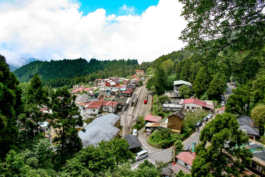
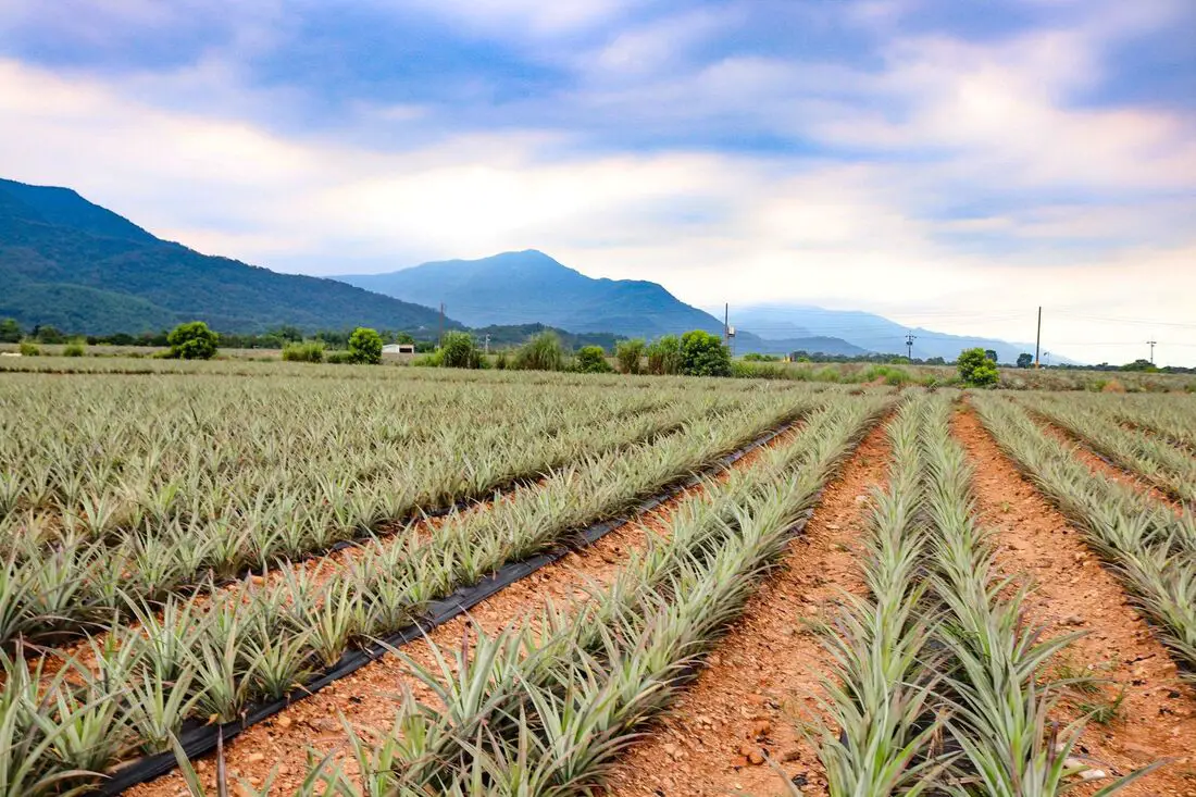
Chiayi is a mostly rural county in south-central Taiwan. Despite its relatively small population compared to other counties in Taiwan, it has some of the most beautiful scenery, delicious local food, and interesting history. Come for Alishan, and stay for everything else you find along the way.
Below I will list out some of the best places in Chiayi that I have visited. I will be sure to update this blog as I visit more places later. How get to Chiayi? You can book tickets to travel to Chiayi via inter-city bus on Klook here. You can book tickets to Chiayi via high speed rail (HSR) on Klook here or KKDay here. Book tickets via the normal train (TRA) on Klook here. How to get around in Chiayi? As always, we recommend renting a scooter as the best way to see Taiwan. However, you can also a great deal of Chiayi by taking the TRA train, Alishan Forest Railway, inter city bus, or local bus. Getting around in a car is also a convenient option as there is plenty of parking pretty much everywhere in this less crowded county. Scooter Rental: Looking for scooter rental in Chiayi? You can check out Klook here or KKday here to search for options. You can also check out our scooter rental guide here. Car Rental: If you are looking for car rentals, you can also search Qeeq here, Klook here, or KKday here. You can also check out our car rental guide here. Bicycle Rental: Looking for bicycle rentals in Taiwan? You can search on KKday here and search for tours on Klook here. You can also check out our Taiwan cycling guide here. Train / Bus: You can purchase tours and tickets of the Alishan Railway through Klook here or KKday here. Book tickets via the normal train (TRA) on Klook here. Tours and Activities: You can purchase tours and tickets for many activities in Chiayi such as glamping, Three Pigs Farm, Janfusun Fancy World, Taiping Suspension Bridge, Chateau de Jourdeness , Kumquat Tourist Factory, Taisugar Siantou Cultural Park, Meteor Garden, Veoveoana Tribe Tour, Danayi Valley, Batongguan Historic Trail, Xianghe Leisure Farm, Foot massage and many others through Klook here or KKday here. Accommodation: We have stayed at and recommend Chiayi Crown Hotel (you can book on Agoda here, Booking.com here, Hotels.com here, or Expedia here), Shin Kao Hotel (you can book on Agoda here or Trip.com here), and YesHotel (you can book on Agoda here, Booking.com here, Hotels.com here, or Expedia here), which are all quality hotels for a reasonable price near Chiayi Station. We also recommend Shianghu Botique Hotel (you can book on Agoda here, Booking.com here, Hotels.com here, or Expedia here), with excellent quality for the money just our of Chiayi City center. Finally we have stayed at and recommend Fenchihu Street Hotel (you can book on Agoda here, Booking.com here, Hotels.com here, or Expedia here), which is within walking distance of Fenqihu Old Street, Fenqihu Station, and many amazing hikes in the area. Find out more about where to stay in our Taiwan hotels guide or search for the best hotel deals in Taiwan here. We recommend booking through Agoda here, which provides the best quality selection of accommodation on the islands. You can also book Wifi and SIM cards for Taiwan on Gigago here. Need travel insurance? Compare prices on Insubuy here. Just to let you know, if you book using the links above, we get some commission at no cost to you, and you can help support our blog. You can click here to receive $5 USD on your first Klook purchase. Map: You can see a map of all the places that we will visit in this blog below: 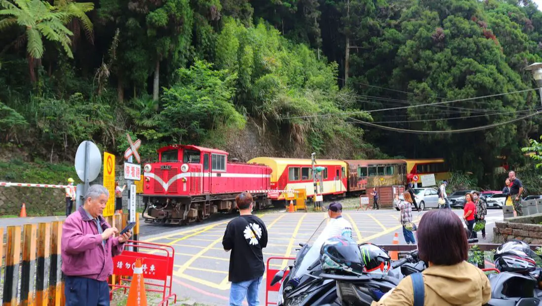
Alishan Forest Railway is one of the most iconic and best preserved historical mountain railways in the world. Starting at the center of Chiayi City, it passes through tropical forests, subtropical hills, and rising into the temperate forests in the mountains, originally ending up at Alishan. It is definitely something you should experience while you are in Taiwan.
Historical Background: The Alishan forest railway was opened in 1912 during the Japanese occupation of Taiwan. Originally it was built to transport lumber from mountain areas in Chiayi County, especially cypress and Taiwania wood. The railway consists of narrow gauge track, and has 50 tunnels and70 wooden bridges. After the Alishan highway was completed in 1982 and logging in Taiwan was banned, passengers along the railway dropped considerably. However, the railway has become popular again in recent years due to its unique and historic preservation. Before the railway from Fenqihu to Zhuqi station was opened, passengers had to disembark at Fenqihu to take a bus to Alishan. In recent years, many parts of the railway have been damaged by floods and landslides, closing parts of the railway for days or even years. Currently the railway from Shizilu to Alishan is still impassible, but hopefully will open soon. The railway is known as one of the most beautiful mountain railways in the world. It is also the highest narrow-gage railway in Asia at 2,451 meters (Chushan Station). Currently the railway attracts visitors from all over the world and is one of the most popular attractions in Taiwan. Hours: Chiayi to Shizilu: First train leaves Chiayi at 8:30 AM Last train leaves Chiayi at 9:00 AM Trains return to Chiayi at around 3:00 PM - 4PM A one way trip takes about two and a half hours. Zhushan: 30 minutes (sunrise train) Shenmu: 7 minutes Zhaoping Line: 6 minutes You can purchase tours and tickets of the Alishan Railway through Klook here or KKday here. Price: 384 NT one way from Chiayi to Fenqihu, 459 NT one way from Chiayi to Shizilu Zhushan Line: 150 NT per ride Shenmu Line: 100 NT per ride Zhaoping Line: 100 NT per ride You can purchase tours and tickets of the Alishan Railway through Klook here or KKday here. How to Buy Tickets: Online: you can purchase tours and tickets of the Alishan Railway through Klook here or KKday here. You can use the online system to buy tickets here. In person: Go to Chiayi Station in person for the Chiayi-Shizilu portion, or Alishan Station for the Zhushan, Shenmu, and Zhaoping lines. The counter to buy tickets is on the right of the main entrance. This is the best way to buy tickets. The online system does not show all tickets and routes available, so if possible it is better to buy in person instead. Where to sit: The best views going up are on the right of the train, and coming down on the left of the train. When to go: Any season. Spring is special because of Cherry blossoms. In the summer (May-October), rock falls due to heavy rains or Typhoons can stop the train for a few days. Make sure to check the train is still running before you go in the summer. Stations: We will cover the following stations in this blog: Chiayi Station 嘉義車站 Beimen 北門站 Lumachan 鹿麻產 Zhuqi 竹奇 Zhangnaoliao 樟腦寮 Dulishan 獨立山 Liyuanliao 梨園寮 Zhaoliping 交力坪 Shuisheliao 水社寮 Fenqihu 奮起湖 Duolin 多林 Shizilu 十字路 First Switch 第一分道 Second Switch 第二分道 Erwanping 二萬平 Shenmu 神木 Alishan 阿里山 Zhaoping 沼平 Shizifendao 十字分道 Dueigaoyue 對高岳 Chushan 祝山 Mian Yue/Tashan Line 眠月線/塔山線 Dongpu Line 東埔線 Shuishan Line 水山線 How to get there: Most passengers board from Chiayi TRA Station or the nearby Beimen TRA Station. Got to Alishan Station for the Zhushan, Shenmu, and Zhaoping lines. You can book tickets to travel to Chiayi via inter-city bus on Klook here. You can book tickets to Chiayi via high speed rail (HSR) on Klook here or KKDay here. Book tickets via the normal train (TRA) on Klook here. Scooter Rental: Looking for scooter rental in Chiayi? You can check out Klook here or KKday here to search for options. You can also check out our scooter rental guide here. Car Rental: If you are looking for car rentals, you can also search Qeeq here, Klook here, or KKday here. You can also check out our car rental guide here. Bicycle Rental: Looking for bicycle rentals in Taiwan? You can search on KKday here and search for tours on Klook here. You can also check out our Taiwan cycling guide here. Tours and Activities: You can purchase tours and tickets for many activities in Chiayi such as glamping, Three Pigs Farm, Janfusun Fancy World, Taiping Suspension Bridge, Chateau de Jourdeness , Kumquat Tourist Factory, Taisugar Siantou Cultural Park, Meteor Garden, Veoveoana Tribe Tour, Danayi Valley, Batongguan Historic Trail, Xianghe Leisure Farm, Foot massage and many others through Klook here or KKday here. Accommodation: We have stayed at and recommend Chiayi Crown Hotel (you can book on Agoda here, Booking.com here, Hotels.com here, or Expedia here), Shin Kao Hotel (you can book on Agoda here or Trip.com here), and YesHotel (you can book on Agoda here, Booking.com here, Hotels.com here, or Expedia here), which are all quality hotels for a reasonable price near Chiayi Station. We also recommend Shianghu Botique Hotel (you can book on Agoda here, Booking.com here, Hotels.com here, or Expedia here), with excellent quality for the money just our of Chiayi City center. Finally we have stayed at and recommend Fenchihu Street Hotel (you can book on Agoda here, Booking.com here, Hotels.com here, or Expedia here), which is within walking distance of Fenqihu Old Street, Fenqihu Station, and many amazing hikes in the area. Find out more about where to stay in our Taiwan hotels guide or search for the best hotel deals in Taiwan here. We recommend booking through Agoda here, which provides the best quality selection of accommodation on the islands. You can also book Wifi and SIM cards for Taiwan on Gigago here. Need travel insurance? Compare prices on Insubuy here. Just to let you know, if you book using the links above, we get some commission at no cost to you, and you can help support our blog. You can click here to receive $5 USD on your first Klook purchase. Maps: Please see a map of all the stations below: 
Tainan is the oldest city in Taiwan and was the capital of Taiwan for over 200 years. It is also said to be the culinary capital of Taiwan, with many traditional Taiwanese snacks that originated here. Surrounded by historical sites, from the Dutch, Koxinga, and Qing Dynasty, it is a great place to enjoy Taiwan's interesting history and its delicious cuisine.
Below I will list some of the best places in Tainan that I have visited. I will be sure to update this blog as I visit more places later. When to visit? Tainan is great year-round, but it can get a little hot in the summer, and Typhoon season and heavy rain season last from about May to October. If you are afraid of the heat and rain then you can visit during winter when the temperatures are mild and the climate is dryer. Where to stay? Most of the accommodation you will find is near the city center. If you only want to visit old Tainan, you can book a hotel near the west part of downtown and consider walking or cycling around the city. We have stayed at and recommend Liho Hotel (you can book on Agoda here, Booking.com here, or Hotels.com here), a quality hotel right next to Chikan Tower, and Famouse Hotel (you can book on Agoda here or Klook here), which is another great hotel also within walking distance of Chikan Tower in old Tainan. You can find out where to stay in our Taiwan hotels guide or search for the best hotel deals in Taiwan here. How to get to Tainan? You can book tickets to travel to Tainan via inter-city bus on Klook here. You can book tickets to Tainan via high speed rail (HSR) on Klook here or KKDay here. Book tickets via the normal train (TRA) on Klook here. Need travel insurance? Compare prices on Insubuy here. How to get around in Tainan: As always, we recommend renting a scooter as the best way to see Taiwan. However, you can also a great deal of Tainan by taking the train, inter-city bus, local bus, Youbike, or just walking. Getting around in a car is also a convenient option as there is plenty of parking pretty much everywhere in this less crowded county. Scooter Rental: Looking for scooter rental in Tainan? You can search KKday here or Klook here to look for options. You can also check out our scooter rental guide here. Car Rental: If you are looking for car rentals in Tainan, you can also search Klook here or KKDay here. You can also check out our car rental guide here. By Bicycle: Cycling is the best way to enjoy Taiwan's landscapes if you have the time and energy. Looking for bicycle rentals in Taiwan? You can search on KKday here and search for tours on Klook here. You can also check out our Taiwan cycling guide here. Tours: You can find more tours and activities in Tainan such as SUPing / Paddle Boarding, Oyster Harvesting, Wind Surfing, Glamping, Life Sciences Museum, Zuojhen Fossil Park, National Museum of Prehistory and Archaeology, Astronomical Education Area, Arphology Museum, Tainan Art Museum, Ten Drum Cultural Village, Shuei Jiao She Cultural Park, Yukids Island, Container Park, Austin Land, Tsou Ma Lai Farm, Reality Game Experience, Thai Massage, Great Wall Exhibition, Wanpi World Wildlife Park, Zengwen Reservoir Yacht Tour, Anping Canal Cruise, Zoumase Farm and more on Klook here or KKday here. You can also book Wifi and SIM cards for Taiwan on Gigago here. Just to let you know, if you book using the links above, we get some commission at no cost to you, and you can help support our blog. You can click here to receive $5 USD on your first Klook purchase. Map: You can see a map of all the places that we will visit in this blog below: 
Taitung has some of the most beautiful scenery in Taiwan, two amazing offshore islands, a striking coastline, deep mountains, and most of all it is bursting with unique aboriginal culture, with indigenous people making up over one-third of the population. It is an unmissable stop on your next trip to Taiwan. Here we have compiled our full guide to Taitung County.
Historical Background: Taitung has been inhabited by the Amis Aboriginal Tribe which has lived there since at least 1500 BC, and over 35% of the people that live there are Taiwan Aborigines. The area is still a center for Amis rituals and traditional ceremonies, as well as aboriginal culture. The east rift valley was also settled by aboriginal tribes such as the Puyuma which relocated from Pingtung. Qing dynasty Chinese farmers started settling there in 1875, as a reaction to the Mudan Incident of 1871 (in which a crew of shipwrecked Japanese sailors were beheaded by Taiwan aborigines) and the Japanese punitive expedition to Taiwan in 1874. After the Japanese took control of Taiwan, Taitung's main industries were growing sugar cane and rice. The eastern railway line was completed in 1926, linking Taitung to the rest of Taiwan. After the ROC took control of Taiwan, Taitung Airport opened in 1981, which further improved transportation links to the region, however, Taitung has remained relatively undeveloped when compared to the rest of Taiwan, and the population of about 200,000 has been in decline for years. However Taitung has become an important tourist destination, and the local government has invested heavily in tourism development. With its untamed and undeveloped landscape, towering mountains, beautiful coastline, and vibrant aboriginal culture, Taitung has become a tourist hot spot in Taiwan. When to go: The best time to go they say is around May when it is not too hot and there are no northeasterly winds or typhoons which can cancel your transportation to the island. The typhoon season lasts from around June to October. The busy season is during summer break from June to August, during which time it can be hard to book a hostel or airplane ticket. Winter is the less crowded season, but the water will be colder, there will be constant wind (which could cancel transportation), and it will rain more often. How to get there: By Plane: Traveling to Taitung by plane is the fastest way to get there. The trip only takes one hour from Taipei, and there are planes that leave daily through Mandarin Airlines and Uni Air. From Taitung, where you can switch to Saily Air which will take you the rest of the way to Green Island or Orchid Island. A plane ticket to Taitung takes about one hour and costs about 5000 NT per round trip. You can book discount tickets to Taitung on KKday here. You can also book cheap flights to Kinmen on Trip.com or CheapO Air. You can also search for cheap flights in Taiwan here. By Train: The train ride from Taipei to Taitung takes 3-4 hours and costs about 800 NT one way. Book tickets via the normal train (TRA) on Klook here. By Car/Scooter: From Taipei, a car ride to Taitung takes about six hours, and a scooter ride takes about eight hours. You can rent a scooter from Taitung Station on Klook or KKday. Scooter rental is about 300 NT per day. You can check out our scooter rental guide here. How to get around: Rent a scooter! Unless you are travelling with small children or elderly people you should not need to rent a car. You can rent bicycles but you will not be able to travel as fast. You can also hire a driver to take you on tours. By scooter: You can rent a scooter from Taitung Station on Klook or KKday. Scooter rental is about 300 NT per day. You can check out our scooter rental guide here. By car / taxi: You can also rent a car for about 1500 NT per day. You can rent a car on Qeeq here or Klook here. You can hire a driver or tax; you can charter a car here. You can check out our car rental guide here. By Bicycle: Cycling is the best way to enjoy Taiwan's landscapes if you have the time and energy. Looking for bicycle rentals in Taiwan? You can search on KKday here and search for tours on Klook here. You can also check out our Taiwan cycling guide here. Accommodation: Booking accommodation in the Taitung can be difficult in the summer months and on weekends. We suggest a better quality selection on Agoda.com. We have stayed at and recommend the Papago International Resort in Chishang (you can book on Agoda here, Booking.com here, Hotels.com here, or Expedia here), which is a five star hotel with private villas with pools for each room, and Mountain and Ocean B & B in Taimali (you can book on Agoda here, Booking.com here, Hotels.com here, or Expedia here), which is a quiet and affordable B&B right next to the beach. You can also find out where to stay in our Taiwan hotels guide or search for the best hotels in Taiwan here. You can also book Wifi and SIM cards for Taiwan on Gigago here. Need travel insurance? Compare prices on Insubuy here. Tours: There are many companies offering snorkeling, diving, SUPing, Surfing, Speed Boating, Glamping, River tracing, and other tours in Taitung. You can find more tours of Taitung on Klook here or KKday here. Just to let you know, if you book using the links above, we get some commission at no cost to you, and you can help support our blog. You can click here to receive $5 USD on your first Klook purchase. Map: See a map of the places we will cover in this blog below: 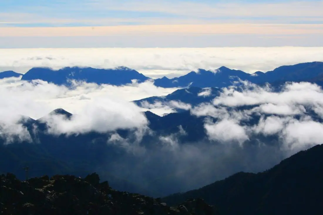
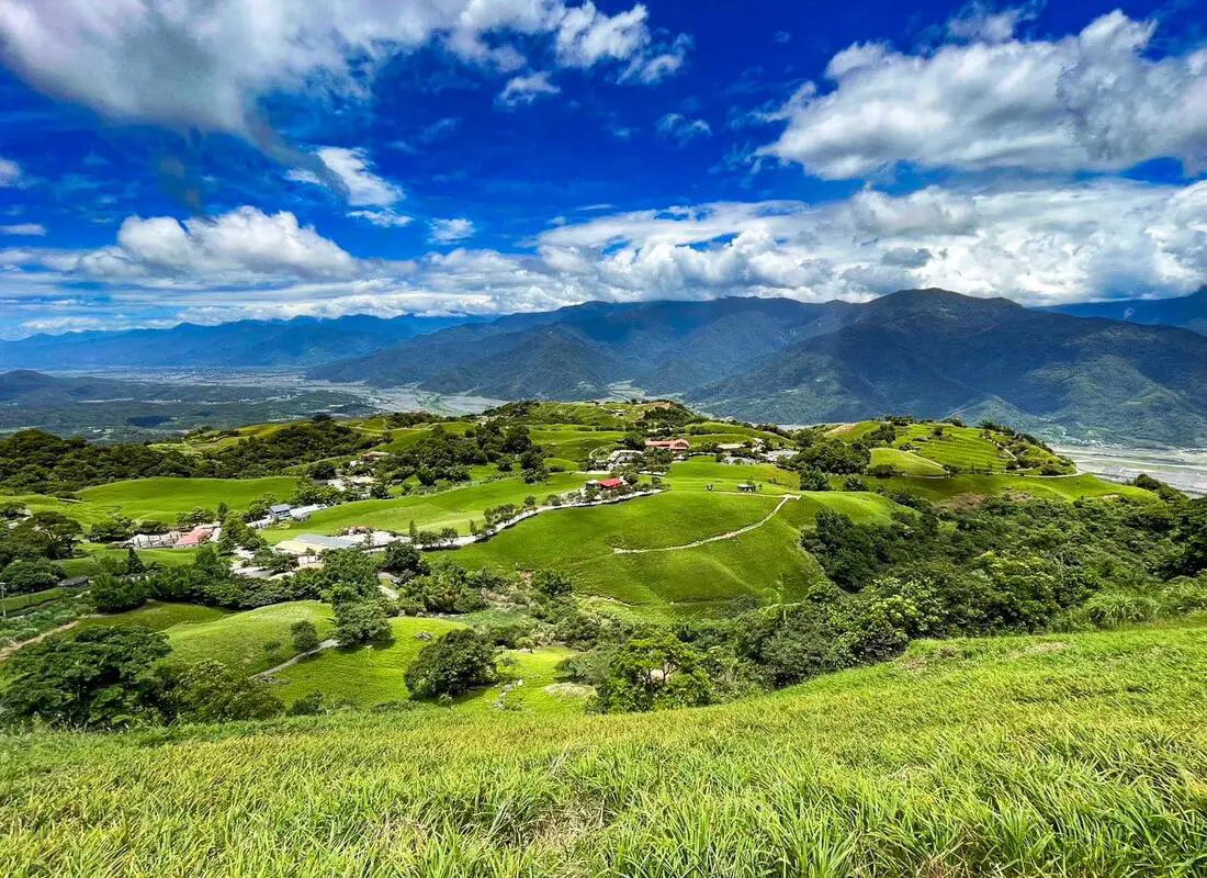
Nantou lies at the heart of Taiwan and is it's only landlocked county. It is known for its rugged natural landscapes and mountains, and includes the highest mountain in East Asia. If you come to Taiwan you should definitely pass through this place and stop by at some of the sights we will mention below.
How to get around Nantou: As always, we recommend renting a scooter as the best way to see Taiwan. However, you can also a great deal of Miaoli by taking the train to Taichung then switching to inter-city bus, or local bus. Getting around in a car is also a convenient option as there is plenty of parking pretty much everywhere in this less crowded county. Scooter Rental: Looking for scooter rental in Nantou? Search Klook here or KKday here to search for options. You can also check out our scooter rental guide here. Car Rental: If you are looking for car rentals, you can also search Qeeq here, Klook here, KKday here. You can also check out our car rental guide here. By Bus: You can book tickets to travel to Nantou via inter-city bus on Klook here. You can book tickets to Taichung via high speed rail (HSR) on Klook here or KKDay here, or book tickets via the normal train (TRA) on Klook here, then switch to a bus to Nantou. Bicycle Rental: Cycling is the best way to enjoy Taiwan's landscapes if you have the time and energy. Looking for bicycle rentals in Taiwan? You can search on KKday here and search for tours on Klook here. You can also check out our Taiwan cycling guide here. Just to let you know, if you book using the links above, we get some commission at no cost to you, and you can help support our blog. You can click here to receive $5 USD on your first Klook purchase. Tours: There are many tours and activities available in Nantou such as river Tracing, paragliding, Shanlinxi Forest Recreation Area 杉林溪, Cona's Chocolate Castle, Shuiyuan Suspension Bridge, JOJOZOO Park, and Aowanda Forest Recreation Area. You can find more tours of Nantou on Klook here or KKday here. Accommodation: We have stayed at and recommend Jenq Yang Hotspring Hotel (you can book on Agoda here, Booking.com here, Trip.com here, or Klook here), a hot spring hotel near the mystical Lushan hot spring, and Maple Leaf Holiday Villa (you can book on Agoda here, Booking.com here, Hotels.com here, Expedia.com here, Trip.com here, or Klook here), a lodge with a great view and within walking distance of Cingjing Farm. I also have stayed at and recommend Kirin Villa (you can book on Agoda here or Booking.com here), a mountain resort in Puli near Sun Moon Lake. Looking for a hotel? Find out where to stay in our Taiwan hotels guide or search for the best hotel deals in Taiwan here. We recommend booking through Agoda here, which provides the best quality selection of accommodation on the islands. You can also book Wifi and SIM cards for Taiwan on Gigago here. Map: Below is a map of these sites: 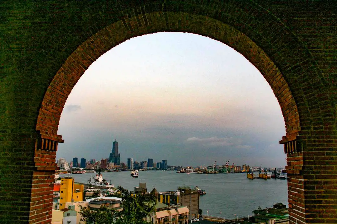
People often don’t realize that Kaohsiung has a lot to offer to tourists. There are many amazing historical and natural sites to see, as well as amazing food, shopping, and interesting culture. Many of the places down south aren’t represented as well in English as other sites in Taipei, which is why we want to help everyone realize what a great place it is. I lived in Kaohsiung for three years and it was like living in paradise every day (I wish I still lived there).
Below I will list some of the best places in Kaohsiung that I have visited. I will be sure to update this blog as I visit more places (and take more photos) later. When to go? Kaohsiung is great year round, but it can get a little hot in the summer, and Typhoon season and the heavy rain season last from about May to October. If you are afraid of the heat and rain then you can visit during winter when the temperatures are mild and the climate is dryer. How to get around in Kaohsiung? By Scooter/Car: As always, we recommend renting a scooter as the best way to see Taiwan. Getting around in a car is also a convenient option as there is plenty of parking pretty much everywhere in this less crowded county. Looking for scooter rental in Kaohsiung? You can check out Klook here or KKday here to search for options. You can check also out our scooter rental guide here. If you are looking for car rentals, you can search Qeeq here, KKday here, or Klook here. You can also check out our car rental guide here. By Public Transport: You can also a great deal of Kaohsiung by taking the MRT, light rail, train, inter city bus, local bus, taxi, or bicycle (U-bike rental). You can book tickets to travel to Kaohsiung via inter-city bus on Klook here. You can book tickets to Kaohsiung via high speed rail (HSR) on Klook here or KKDay here. Book tickets via the normal train (TRA) on Klook here. You can also book a Kaohsiung Travel pass here. By Bicycle: Cycling is the best way to enjoy Taiwan's landscapes if you have the time and energy. Looking for bicycle rentals in Taiwan? You can search on KKday here and search for tours on Klook here. You can also check out our Taiwan cycling guide here. Accommodation We have stayed at and recommend Chao She Hotel (you can book on Agoda here, Booking.com here, Hotels.com here, or Expedia here) IHI Sanduo Travel Hotel (you can book on Agoda here, Booking.com here, Hotels.com here, or Expedia here), and Mingli Hotel (you can book on Agoda here, Klook here, or Hotels.com here) which are three inexpensive and high quality choices in downtown Kaohsiung. I also have stayed at and recommend Kaohsiung Meinong Rabbit Paul Homestay B&B (you can book on Agoda here, Booking.com here, or Trip.com here), a quiet B&B in rural Meinong, and Chengching Lakeside Resort (you can book on Agoda here, Booking.com or Trip.com here)and the Grand Hotel Kaohsiung (you can book on Agoda here, Booking.com here, Hotels.com here, or Expedia here) which both offer breakfast buffet and free entrance into Chenqing Lake Park. I have also stayed at the 85 sky tower which offers great views of the city; you can search for rooms in the 85 sky tower on Agoda here, Booking.com here, Hotels.com here, Expedia here, or Trip.com here). Find out more about where to stay in our Taiwan hotels guide or search for the best hotel deals in Taiwan here. We recommend booking through Agoda here, which provides the best quality selection of accommodation on the islands. You can also book Wifi and SIM cards for Taiwan on Gigago here. Need travel insurance? Compare prices on Insubuy here. Tours: You can find more tours and activities in Kaohsiung such as Pier 2, Meinong Hakka Museum, Hamasen Railway Museum, Suzuka Circuit Park, i-Ride Kaohsiung Visual 5D Flying Theater, National Science and Technology Museum , Senya Village Restaruant, Austin Land, Ski School Indoor Ski Slope, and many more on Klook here or KKday here. Just to let you know, if you book using the links above, we get some commission at no cost to you, and you can help support our blog. You can click here to receive $5 USD on your first Klook purchase. Map: 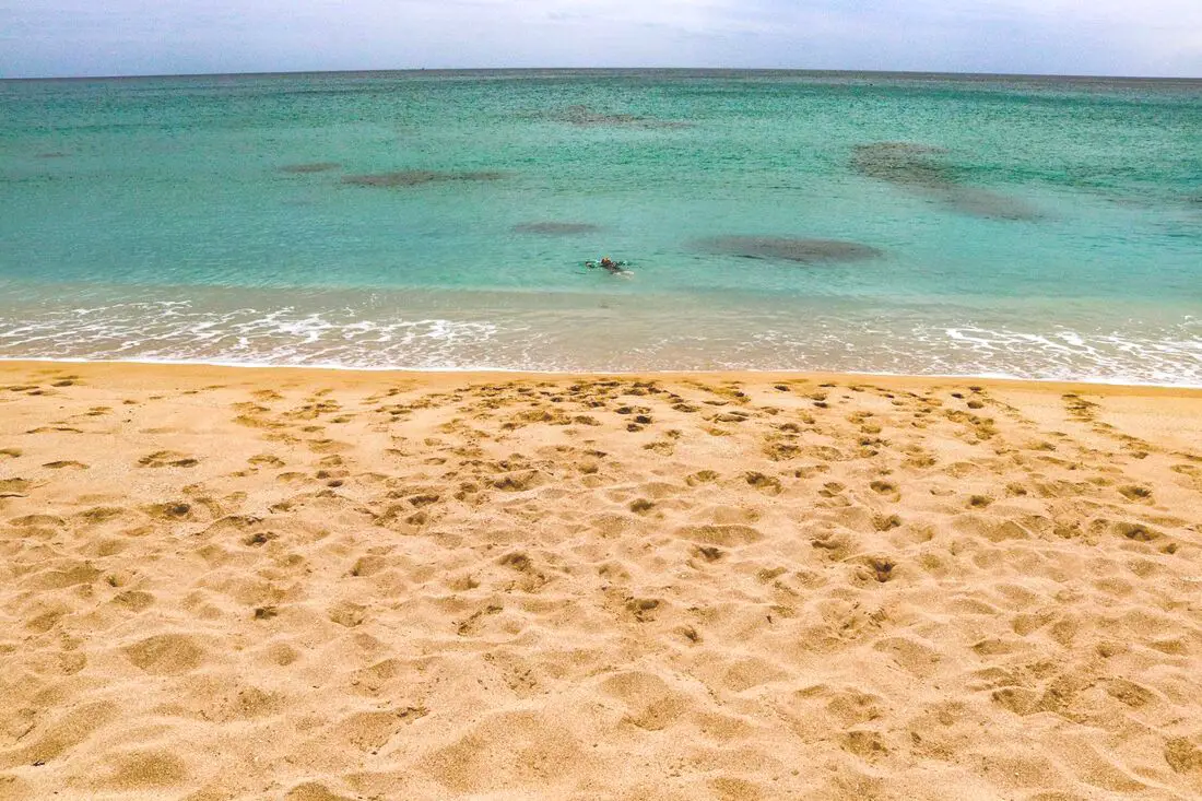
Yes, you should go to Kenting. Kenting has some of the best natural scenery in Taiwan, from beautiful white sand beaches that are warm year round to limestone mountains with hundreds of caves and waterfalls to explore. Although it may not be a world class beach resort destination yet, it should definitely be on your list on your trip to Taiwan.
Background: The area around the Hengchun Peninsula was once coral that has been uplifted over millions of years. The first people to live here were Taiwan aboriginals, from the Paiwan and Puyuma tribes (who caused the Rover Incident as portrayed in Seqalu: Formosa 1867). Kenting was first settled by Han farmers and fishermen during the Qing Dynasty. The word Kenting comes from two words that mean cultivate (ken3 墾) and strong man (丁 ding1). During that time, a group of strong men (or Zhuang Ding 壯丁) came from Guangdong, who were basically Chinese pioneers of the area to cultivate the land, hence the area was named Kenting for them. The aboriginal people were mostly assimilated with the local Chinese population. The area was considered to be made into a park during the Japanese occupation due to it being the only tropical location in the Japanese Empire, but was never officially created. During the Japanese era, Nanwan was used as a whaling area and there were a few fishing villages here. The Whaling industry continued here in the ROC era until the international ban on whaling in 1986. Kenting National Park was established in 1984 as the first national park in Taiwan after WWII. Kenting became a major vacation spot, becoming a center for hostels and hotels for travelers. Kenting is considered by many to have the best beaches in Taiwan. This is because of its fine white sand and year-round warm temperatures and sunshine (it is in the tropical part of Taiwan after all). When to go: Summer is the best time to go because there is warm sunny weather and not a lot of wind. However, there are more people and there may be Typhoons. Winters are windy and colder, but the water is still warm enough to swim in. Winter is a better time for activities like hiking and surfing. How to get there: By Car/Scooter: Take provincial highway 1 south to the bottom of Taiwan until it becomes provincial highway 26. After that keep going past Hengchun into Kenting National Park. Looking for scooter rental in Kenting? Click here or here to search for options. If you are looking for car rentals, you can also search Qeeq here, Klook here, or KKday here. You can also check out our car rental guide here. By Bus: Busses leave daily to Kenting from Zuoying HSR station, Kaohsiung Station, and Pingtung. You can book tickets to Kenting via high speed rail (HSR) on Klook here or KKDay here, or book tickets via the normal train (TRA) on Klook here. You can book tickets to travel to Kenting via inter-city bus on Klook here. Once in Kenting, you can save money by booking Kenting's bus pass. By Plane: There are direct shuttle busses to Kenting from Kaohsing's Xiaogang (KHH) Airport. You can search for cheap flights in Taiwan here. By Bicycle: Cycling is the best way to enjoy Taiwan's landscapes if you have the time and energy. Looking for bicycle rentals in Taiwan? You can search on KKday here and search for tours on Klook here. You can also check out our Taiwan cycling guide here. Where to stay: Looking for a hotel? Find out where to stay in our Taiwan hotels guide or search for the best hotel deals in Taiwan here. We recommend booking through Agoda here, which provides the best quality selection of accommodation in Taiwan. I have stayed at many hostels and hotels in Pingtung, and even almost bought a house here. Some places that I have stayed at and can recommend are Nanwan Kiki (book on Agoda here, Booking.com here), a B&B next to Nanwan Bay, Kenting's most popular Beach. There are also a few decent hotels near Kenting Street Night Market like Kenting Star Inn 888 (book on Agoda here, Klook here, or Booking.com here), or Kenting Dajianshan Hotel (book on Agoda here or Booking.com here). You will notice that none of these hotels are five star resorts (I do not come to Kenting to waste my time at a resort, but you can still search Agoda, Booking.com, or Klook here for those) but they are in my opinion the above have the best value for the money. How to get around in Kenting: 1. Rent a scooter - the best way to see Taiwan. Electric scooters that do not require a license are also readily available. For better range and speed, rent a gas scooter. You can search for scooter options here or here, and you can check out our scooter rental guide here. 2. Rent a car - more expensive than a scooter but may be more suitable for a large family. If you are looking for car rentals, you can also search Qeeq here, Klook here, or KKday here. You can also check out our car rental guide here. 3. Take the Kenting bus - cheap but slower than your own transportation, and it doesn't stop everywhere. You can book tickets to travel to Kenting via inter-city bus on Klook here. 4. Cycle - you can rent a bicycle or bring your own. This is a great way to enjoy the scenery at a slower pace. You can search on KKday here and search for tours on Klook here. You can also check out our Taiwan cycling guide here. 5. Hire a taxi - more expensive than a rental car but perhaps more convenient. You can also search for a car charter service here or here. Tours and Activities in Kenting: There are many activities available in Kenting, such as snorkeling, diving, SUPing, surfing, submarine riding, and river tracing. You can find more tours of Kenting on Klook here or KKday here. Just to let you know, if you book using the links above, we get some commission at no cost to you, and you can help support our blog. You can click here to receive $5 USD on your first Klook purchase. Map of sites in this blog: 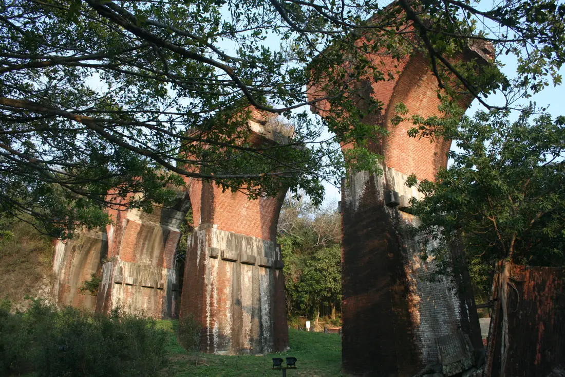
For you expats or foreigners who have never left Taipei, Miaoli is a large rural county in central Taiwan. For years I myself never visited, because I didn't know what was there and had no reason to go. It turns out there are quite a few attractions here in this secret paradise.
Below I will list out some of the best places in Miaoli that I have visited. I will be sure to update this blog as I visit more places later. How to get around in Miaoli? As always, we recommend renting a scooter as the best way to see Taiwan. However, you can also a great deal of Miaoli by taking the train, inter city bus, or local bus. Getting around in a car is also a convenient option as there is plenty of parking pretty much everywhere in this less crowded county. By scooter: Looking for scooter rental in Miaoli? Check out Klook here or KKday here to search for options. You can also check out our scooter rental guide here. You can also check out our car rental guide here. By car: If you are looking for car rentals, you can also search Qeeq here, Klook here, or KKday here. You can also check out our car rental guide here. By bus: You can book tickets to travel to Miaoli via inter-city bus on Klook here. You can book tickets to Miaoli via high speed rail (HSR) on Klook here or KKDay here. Book tickets via the normal train (TRA) on Klook here. By Bicycle: Cycling is the best way to enjoy Taiwan's landscapes if you have the time and energy. Looking for bicycle rentals in Taiwan? You can search on KKday here and search for tours on Klook here. You can also check out our Taiwan cycling guide here. Tours: There are many tours and activities available in Miaoli such as Schokolake Chocolate Factory, Shangshun World, West Lake Resortopia, Suweila Manor, Baba Kengdao, Hobbit Valley, Zhuo Ye Cottage Duck Box and more on Klook here or KKday here. Accommodation: We have stayed at and recommend Beautiful Landscape Resort, a fish farm and resort near Nanzhuang Old Street (you can book on Agoda here, Booking.com here, Hotels.com here, or Expedia here), and Yuan Motel, a high class car motel which includes a great breakfast buffet (you can book on Agoda here, Booking.com here, Hotels.com here, or Expedia here). We also recommend Flying Cow Ranch which includes cabins and camping right on the tourist ranch; you can book a room on Agoda here, Booking.com here, or Trip.com here. Looking for a hotel? Find out where to stay in our Taiwan hotels guide or search for the best hotel deals in Taiwan here. You can also book Wifi and SIM cards for Taiwan on Gigago here. Need travel insurance? Compare prices on Insubuy here. Just to let you know, if you book using the links above, we get some commission at no cost to you, and you can help support our blog. You can click here to receive $5 USD on your first Klook purchase. Map: You can see a map of all the places that we will visit in this blog below: 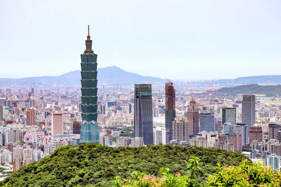
Are you wondering what to do, see, and eat during your trip to Taipei? We have all the answers here in this ultimate travel guide. From the abundant food options, night markets, historical sights, mountains, and natural beauty of the area, there are endless activities and sights to enjoy for any amount of time.
About the author: I am a long-time Taipei resident. So far I have lived over 7 years in Taipei City. Originally I am from the USA, but I now call Taiwan my home. Specifically, I currently live in Nangang District, but I have also lived in Da'an District and Sanchong. Exploring Taipei is my passion. Brief Historical Background of Taipei: The land on which Taipei now stands on what was once part of Basay tribal land. The Basay people had lived on the land for thousands of years before the first Chinese settlers ever came. Chinese settlers from Fujian began living here during the Dutch rule in the 1600s. The first Chinese settlers came to the area in the mid-1800's during the Qing Dynasty. They created a public area for drying rice and grain, called Dadaocheng (大稻埕) which also became the central market in the area. The earliest trading shops were built in 1851, mainly selling rice, sugar, camphor, and tea. Dihua Street (迪化街) was created around this time, making it the oldest street in Taipei. Most of the buildings were one story and made of red brick in Fujian style, and later western style houses were built. The walls and gates of Taipei were completed in 1884. In 1891, the first train connecting Keelung and Taipei was completed. During the Japanese era, in 1904 the walls of Taipei were destroyed after less than 30 years, and Taipei was re-planned into the capital of Taiwan. After the ROC took control of Taiwan, Taipei continued as the capital city, as well as the financial hub of Taiwan. During the Taiwan miracle, many rural families moved from southern Taiwan to factories and offices in Taipei, making Taipei the most populous urban area in Taiwan. Currently, Taipei is the most advanced and affluent city in Taiwan. It also has Taiwan's most advanced public transportation system, making it easy for millions of commuters to live outside the city where rents are cheaper. Now, most of Taiwan's economic activity is based in this city. Basic Taipei Travel Tips:
When should you go to Taipei? In my opinion, the best weather in Taipei is from March-May, and October - November, when the temperatures stay around 26 degrees Celsius and there is not as much rain. Summers are also nice, with the most sunny weather, but also hot and rainy. Winters can be cold (but not below freezing) and usually wet. Overall, there is no wrong answer as to what time of year you should visit Taipei. You will have a great time here at any time of year. Hotels in Taipei: High end: We have stayed at and recommend the Yuanshan Grand Hotel, once the tallest building in Taiwan and still the most grand (book on Booking.com here, Tripadvisor here, or Agoda here). We have also stayed at and recommend the Grand Hyatt (book on Booking.com here, Tripadvisor here, Agoda here, or Hotels.com here), Marriot (book on Booking.com here, Tripadvisor here, Agoda here, or Hotels.com here), Sheraton (book on Booking.com here, Tripadvisor here, Agoda here, or Hotels.com here), Shangri-la (book on Booking.com here, Tripadvisor here, Agoda here, or Hotels.com here), and Regent (book on Booking.com here, Tripadvisor here, Agoda here, or Hotels.com here), which are all very high quality hotels in the middle of Taipei City. We also recommend Fullon Hotel which has locations in Tamsui and Fulong near the beach (book on Booking.com here, Tripadvisor here, Agoda here, or Hotels.com here). Budget Hotels: We have stayed at and also recommend Fu Chang Hotel in Ximending, which is within walking distance of Ximending shopping district (book on Booking.com here, Tripadvisor here, or Agoda here). We have also stayed at and recommend Hai Xia Your Home which is right in front of Fulong Beach (book on Booking.com here, Tripadvisor here, Agoda here, or Hotels.com here). Looking for a hotel? We recommend booking through Booking.com here, which provides the best quality selection of accommodation in Taiwan. Find out where to stay in our Taiwan hotels guide or search for the best hotel deals in Taiwan here. Attractions in Taipei: There are many attractions that you can enjoy in Taipei such as Taipei 101 Observatory, Taipei 101 460 Skyline Observatory, Taipei Children's Amusement Park, Maokong Gondola, National Palace Museum, Yehliu Ocean World, Yehliu Geopark, National Museum of Marine Science and Biology, i-ride 5D cinema, Astronomical Museum, Miniatures Museum of Taiwan, Double Decker Sightseeing Bus, Miramar Ferris Wheel Ticket, Taipei Zoo, Heping Island Park, Ju Ming Museum, Yuanshan Hotel Secret Road, National Taiwan Museum, New Taipei Gold Museum, Futian Leisure Farm, Chiang Kai-shek Shilin Residence, Chi Po-lin Museaum, Beitou Museum, Tsao Wonderland, Railway Museum, Fort San Domingo, 13 Levels Archaeology Museum, Austin Land, Museum of World Religions, Formosan Aboriginies Museum, ASE Parent-child Park, teamLab Future Park, Yukids Island, VR Experience, Bat Cave, Neidong Waterfall, Candlestick Islet, Jurassic Snow Park, Zhonghe High5 Amusement Park, Longshan Temple, Xingtian Temple, Ningxia Night Market, Yansan Night Market, Meteor Garden, Yingge Old Street, and many more attractions on Tripadvisor here, Klook here, or KKday here. Activities in Taipei: Don't forget that there are many activities available in Taipei such as Indoor Skiing, Rock Climbing, Hiking, Wakeboarding, Surfing, Speedboat Surfing, SUP / Paddle Boarding, Diving, Snorkeling Kayaking, Canoeing, Water Biking, River Tracing / Canyoneering, ATVing, Horse Riding, Cooking Class, Archery, Ice Skating, Roller Skating, Tree Climbing, Urban Camping, Glamping, Motorcycling, Motorbike Tour, Dragon Boat Racing, Escape Room, Shen'ao Rail Bike, Laser Gun Experience, Batting Cages, Bowling, Paintball, Flight Simulation Experience, Taipei Tram Driving Experience, Rail Simulation Experience, Taipei 101 Observation Deck activity, Strawberry Picking, Professional Photo Shoot, Body Relaxation SPA, Night Tour, Calligraphy Workshop, and more on Tripadvisor here, Klook here, or KKday here. Just to let you know, if you book using the links above, we get some commission at no cost to you, and you can help support our blog. Some of the Klook links may not work if you are using an Ad blocker. You can click here to receive $5 USD on your first Klook purchase. How to get there: The only way to get to Taiwan is via airplane. Planes leave daily from Taipei's Songshan and Toayuan Airport. Taoyuan Airport: Taoyuan is Taiwan's largest airport and typically has cheaper flights and more flight times to choose from. It's about an hour's journey from Taoyuan Airport to the center of Taipei. You can travel via MRT, HSR, bus, or taxi to get to Taipei. You can get 30% off the Taoyuan Airport VIP lounge on KKday here. Songshan Airport: Songshan is a small airport in Taipei's city center, and can be a convenient option for people traveling within Asia. The airport is right on the Taipei MRT brown line. You can book cheap flights to Taiwan on KKday here, Trip.com here, CheapO Air here, or Kiwi here. How to get around in Taipei: Taipei's transportation system is convenient and safe. There are many options you can consider to get around in Taipei below: By Train: Gets you to the city center of all major cities in Taiwan. It is about 800NT to get from Taipei to Kaohsiung. Roughly half the price of the HSR. Book tickets via the normal train (TRA) on Klook here. By HSR: (High-Speed Rail) – Gets you quickly from north to south. Besides Taipei and Kaohsiung, most of the stations are far from city centers. It costs about 1500NT to get from Taipei to Kaohsiung. You can book tickets to the high-speed rail (HSR) on Klook here or KKDay here. By MRT: (Mass Rapid Transit, Metro train, subway) – Easily gets you around Taipei and Kaohsiung. You can purchase a discount easy card to use on the MRT from Klook here or KKday here. You can also book an MRT travel pass on Klook here. By Bus: Buses can be tricky. Long-range buses such as Ubus and King Bus are easier to understand and cheaper than the local train. They can take you to the city center of every city throughout Taiwan and to remote tourist destinations such as sun moon lake. A long-range bus from Taipei to Kaohsiung is about 500 NT. You can also book tickets to travel to Shifen via inter-city bus on Klook here. You can also book a Taipei Sightseeing: Hop On, Hop Off Open Top Bus on TripAdvisor here. By Taxi: You can take short rides for about 150 NT, or hire a Taxi for a day for around 150 USD. By Car: If you are looking for car rentals, you can also search Qeeq here, Klook here, or KKday here. You can also check out our car rental guide here. By Scooter: Looking for scooter rental in Taipei? You can search on Klook here or KKday here to search for options. You can also check out our scooter rental guide here. By Bicycle: Cycling is the best way to enjoy Taiwan's landscapes if you have the time and energy. Looking for bicycle rentals in Taiwan? You can use Taiwan's many Youbike sharing stations, or search for rentals on KKday here, and search for tours on Klook here. You can also check out our Taiwan cycling guide here. ​You can also book a Sunset Riverside Bike Ride and Historical Tour, 4 Hour Cycling in Taipei, Ultimate 8-Hour Cycling City Tour, or Taipei City Bike Tour with Night Market Experience on TripAdvisor here. For more information, check out our Taiwan transportation guide here. Tourist Site Map: Check out our map below of tourist sites in Taiwan, which is constantly updated: 
Hualien is the largest county in Taiwan and is considered by many to be the most beautiful. It includes a breathtaking coastline along the Pacific Ocean, including cliffs thousands of meters high, marble gorges, fertile valleys, and a large section of Taiwan's central mountain range. Hualien is simply a must-stop location on your trip to Taiwan.
Historical Background Hualien was first inhabited by Sakiraya aborigines and was known as Kilai. Later the Spanish came here to pan for gold for a brief period. Afterward, the first Han Chinese settlers came to the area in 1851 and named the place Hualien after the swirling delta of the Liwu River. During the Japanese era, many Japanese people were relocated here to develop agriculture. Now Hualien is the key population center on Taiwan's East Coast. When to visit? Hualien is great year round, but it can get a little hot in the summer, and Typhoon season and heavy rain season last from about May to October. If you are afraid of the heat and rain then you can visit during winter when the temperatures are mild and the climate is usually dryer. Where to stay? The best hostel I’ve ever stayed at is “When Happiness Knock Your Door” “幸福來敲門” in Hualien. The hostess will go out of her way to make you comfortable and her rooms are kept extremely nice. Also it was one of the few hostels I’ve ever been to that has an elevator. Her price is well below the quality you will enjoy. She has almost a perfect rating on Booking.com and Agoda. You can book When Happiness Knock Your Door on Agoda here, Booking.com here, Hotels.com here, Expedia here, Kayak here, TripAdvisor here, or Klook here. We have also stayed at and recommend Dream Taiwan Homestay (Agoda / Booking.com / Expedia / Hotels.com), a high quality hostel for the money in downtown Hualien, Farglory Hotel (Agoda / Booking.com / Expedia / Hotels.com), right next to Farglory Ocean Park with amazing views of Hualien, and Goldenflower B&B (Agoda / Booking.com) in Yuli right next to Sixty Stone Mountain. You can find out where to stay in our Taiwan hotels guide or search for the best hotel deals in Taiwan here. How to get to Hualien? You can book tickets to travel to Hualien via inter-city bus on Klook here. Book tickets via the normal train (TRA) on Klook here. Need travel insurance? Compare prices on Insubuy here. How to get around in Hualien: As always, we recommend renting a scooter as the best way to see Taiwan. However, you can also a great deal of Tainan by taking the train, inter-city bus, local bus, biking, or just walking. Getting around in a car is also a convenient option as there is plenty of parking pretty much everywhere in this less crowded county. Scooter Rental: Looking for a scooter rental in Hualien? You can search KKday here or Klook here to look for options. You can also check out our scooter rental guide here. Car Rental: If you are looking for car rentals in Hualien, you can also search Klook here or KKDay here. You can also check out our car rental guide here. By Bicycle: Cycling is the best way to enjoy Taiwan's landscapes if you have the time and energy. Looking for bicycle rentals in Taiwan? You can search on KKday here and search for tours on Klook here. You can also check out our Taiwan cycling guide here. Tours: You can find more tours and activities in Hualien such as Surfing, Paragliding, SUP / Paddle Boarding, Kayaking, Canoeing, River Tracing, River Rafting, Whale Watching, Snorkeling, Diving, ATV / 4-wheeling, Paintballing, Farm Dream Estates Zoo, Water Biking, Oyster Harvesting, Shrimp Harvesting, Indigenous Experience, Glamping, Cycling, Ziplining and much more on Klook here or KKday here. You can also book Wifi and SIM cards for Taiwan on Gigago here. Just to let you know, if you book using the links above, we get some commission at no cost to you, and you can help support our blog. You can click here to receive $5 USD on your first Klook purchase. Map: Please see the map below for the areas we will cover in the blog. 
For you expats or foreigners who have never left Taipei, Changhua is a large mostly rural county in central Taiwan. For years I myself never visited, because I didn't know what was there and had no reason to go. It turns out there are quite a few attractions here in this secret paradise.
Below I will list some of the best places in Changhua that I have visited. I will be sure to update this blog as I visit more places later. Historical Background: Before Han settlement, Changhua was inhabited by native peoples. During the Dutch era in Taiwan, a well was made to tap into the Zhuokou River water table. The Red Hair Well was made around 1611 by Dutch colonizers and was often used by Dutch soldiers and missionaries, During the Qing Dynasty, the city of Lukang became an important trading port, because of the depth of the water and the fact that it was closer to Fujian province than other cities in Taiwan. The main product shipped to Fujian was rice. In the 1800s, Lukang was Taiwan's second largest city, with as many as 20,000 residents, even more than Banka (modern day Taipei) and second only to Tainan. Later on, the port began to silt in, and the railroad bypassed the city, meaning that economic activity here went downhill. However because the city has changed so little in the past 200 years, it has become a cultural relic preserved from the past. The city also has over 200 temples. After the railroad was moved to Changhua City, it became the most important economic region in the county. Despite being the smallest county in Taiwan by area, Changhua County is the most populous county in Taiwan. It is often described as being part of the Taichung-Changhua metropolitan area. How to get around in Changhua? As always, we recommend renting a scooter as the best way to see Taiwan. However, you can also a great deal of Changhua by taking the train, inter-city bus, or local bus. Getting around in a car is also a convenient option as there is plenty of parking pretty much everywhere in this less crowded county. By Scooter: Looking for scooter rental in Changhua? Check out Klook here or KKday here to search for options. You can also check out our scooter rental guide here. By Car: If you are looking for car rentals, you can also search Qeeq here, Klook here, or KKday here. You can also check out our car rental guide here. By Bus/Train: You can book tickets to travel to Changhua via inter-city bus on Klook here. You can book tickets to Changhua via high speed rail (HSR) on Klook here or KKDay here. Book tickets via the normal train (TRA) on Klook here. By Bicycle: Cycling is the best way to enjoy Taiwan's landscapes if you have the time and energy. Looking for bicycle rentals in Taiwan? You can search on KKday here and search for tours on Klook here. You can also check out our Taiwan cycling guide here. Accommodation: We have stayed at and recommend Guide Hotel Changhua Jhongjheng, which is one of our favorite hotels in all of Taiwan, with great quality and service right in downtown Changhua. (book on Agoda here, Booking.com here, Hotels.com here, Expedia here, or Trip.com here) Looking for a hotel? We recommend booking through Agoda here, which provides the best quality selection of accommodation on the islands. Find out where to stay in our Taiwan hotels guide or search for the best hotel deals in Taiwan here. You can also book Wifi and SIM cards for Taiwan on Gigago here. Need travel insurance? Compare prices on Insubuy here. Tours: Tours and activities in Changhua include Magical Mushrooms Leisure Farm, Cheng Mei Cultural Park, Changhua Love Farm, Gushengwu Paleontology Park, Taiwan You Good School of Cookie, Baiguoshan Amusement Park, Yunhe Starry Sky View Restaruant , Tianzhong, Yakuta Experience , Qingshui Hot Spring Glamping, Fruit Picking , Tonight Star Leisure Farm, Tianweiwang Scenic Spot, and more. You can find more tours of Changhua on Klook here or KKday here. Just to let you know, if you book using the links above, we get some commission at no cost to you, and you can help support our blog. You can click here to receive $5 USD on your first Klook purchase. Map: You can see a map of all the places that we will visit in this blog below: 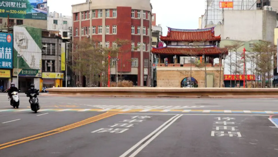
Hsinchu is not only Taiwan's technological hub, but is also rich with historical sights, Hakka culture, and natural beauty. It has numerous old streets, preserved Japanese-era and Qing-era buildings, zoos, mountains, lakes, rivers, beaches, and much more to explore. It is definitely worth a stop on your next trip to Taiwan.
History of Hsinchu: After the settlement of the area by Han Chinese farmers in about 1711, what was then known as Zhuqianshe became the most important economic area in northern Taiwan. By 1723, a walled city was built here out of bamboo, because brick walls were forbidden for fear of a revolt against the Qing authorities. The name Zhuqiancheng (竹塹城) literally means bamboo moat city. The bamboo-walled city had four gates and its perimeter was about 1.4 KM long. In 1806, the city was upgraded with earthen walls. In 1828, the city walls and gates were finally made into brick, with the perimeter covering 2.7 KM, and walls 5 meters high, the center of the city being the Chenghuang City God Temple. In 1901, the Japanese government decided to redesign the City of Hsinchu and destroyed all the gates and walls except the existing East Gate. In the ROC era, the Hsinchu Science Park was established in 1980 under President Chiang Jingkuo, and was made to model silicon valley. TSMC, Taiwan's most important corporation, was formed in 1987 with its headquarters in the park and created a technological hub, making Hsinchu indispensable to Taiwan's economy. When to visit: It is best to visit from April to November when the weather is warm and less windy. There is a constant, cold northeasterly wind from December to March especially along the coast. However, the winter in general is more dry. Where to stay: Most of the accommodation you will find is near the city center. If you will only visit downtown, you can consider a day trip from Taipei. We have stayed at and recommend the Golden Motel a high quality motel near Green Grass Lake (you can book on Agoda here, Booking.com here, Hotels.com here, Expedia here, or Trip.com here), and CD Motel, another high quality motel in downtown Hsinchu (you can book on Agoda here, Booking.com here, or Trip.com here). Unfortunately I cannot recommend any further hotels that I have stayed at in Hsinchu because usually we stay at my wife's uncle's house. You can find out where to stay in our Taiwan hotels guide or search for the best hotel deals in Taiwan here. You can also book Wifi and SIM cards for Taiwan on Gigago here. Need travel insurance? Compare prices on Insubuy here. How get to Hsinchu? You can book tickets to travel to Hsinchu via inter-city bus on Klook here. You can book tickets to Hsinchu via high speed rail (HSR) on Klook here or KKDay here. Book tickets via the normal train (TRA) on Klook here. How to get around in Hsinchu: As always, we recommend renting a scooter as the best way to see Taiwan. However, you can also a great deal of Hsinchu by taking the train, inter-city bus, or local bus. Getting around in a car is also a convenient option as there is plenty of parking pretty much everywhere in this less crowded county. Scooter Rental: Looking for scooter rental in Hsinchu? You can search Klook here or KKday here to look for options. You can also check out our scooter rental guide here. Car Rental: If you are looking for car rentals in Hsinchu, you can also search Qeeq here, Klook here, or KKDay here. You can also check out our car rental guide here. By Bicycle: Cycling is the best way to enjoy Taiwan's landscapes if you have the time and energy. Looking for bicycle rentals in Taiwan? You can search on KKday here and Klook here. You can also check out our Taiwan cycling guide here. Tours: You can find more tours and activities in Hsinchu such as You can find more tours and activities in Hsinchu such as river tracing, wild hot springs, white water kayaking, backpack rafting, Little Ding Dong Theme Park, Leofoo Village Theme Park, Window on China Theme Park, glamping, camping, stone spa, horse riding, Yukids Island, Tom and Bei Bei Parent Child Paradise, bee keeping experience, cycling, dried persimmons experience, Jump Wave Trampoline Park and more on Klook here or KKday here. Just to let you know, if you book using the links above, we get some commission at no cost to you, and you can help support our blog. You can click here to receive $5 USD on your first Klook purchase. Map: See below for a map of places we will cover in this blog: 
Green Island is a paradise off the southeastern coast of Taiwan. Once a prison for political enemies of the KMT, it is now a tourist hot spot. It is one of the best places to snorkel and dive in Taiwan, one of only three saltwater hot springs in the world, and it also includes amazing volcanic rock formations and scenery all around the island.
Background: Green Island is the remnant of a volcano that formed millions of years ago and is part of the Luzon Volcanic Arc. Today you can see lots of volcanic rock all along the shoreline. Green Island is the seventh largest Island in Taiwan. Green Island became inhabited hundreds of years ago by the Tao indigenous people (達悟族) (aka Yami people 雅美族, which is a name coined by the Japanese, but the native people prefer Tao), which are thought to have traveled from the Batanes Islands in the Philippines, and then to Orchid Island. It was called Jitanasey by the Tao people. It was also known to be inhabited by the Amis Tribe (阿美族) who reside today in Taitung. It was known by the Amis people as Samasana Island. The Island was first settled by Han Chinese fisherman from Xiaoliuqiu Island in 1813, who called the island Huoshandao (火燒島) or Bonfire Island. More Han settlers from Donggang arrived in 1850. In 1937 the American Steamship SS President Hoover ran ground at Green Island and all aboard were saved. To thank the people of Green Island, the US donated to build the Green Island Lighthouse which was designed by the Japanese and finished in 1938, at 33.3 meters or 109 feet high. Green Island also served as a penal colony for political prisoners' during the martial law era of Taiwan, which lasted from the late 9140s to the late 1980s. Some prisoners went on to help form the Democratic Progressive Party. The prison is now open to the public. Currently, the Island is powered by one diesel generator. It also includes an airport. Currently about 4500 people live on the island, and the main industries are tourism and fishing. Weather and Climate: The island has a tropical rainforest climate, with average high temperatures between 20 and 30 degrees year round. The rainy months are in summer, especially due to Typhoons, but the most sunny days are also in summer (expect a lot of sun), and the most rainy days are in winter. Summer is the tourist season, but spring and fall are also popular times to visit. Winters are said to be dreary, cold, and have constant northeastern winds that can stop airplanes and ferries from departing to the island. When to go: The best time to go they say is around May when it is not too hot and there are no northeasterly winds or typhoons which can cancel your transportation to the island. Typhoon season lasts from around June to October. The busy season is during summer break from June to August, during which time it can be hard to book a hostel or airplane ticket. Winter is the less crowded season, but the water will be colder, there will be constant wind (which could cancel transportation), and it will rain more often. Rules to Consider:
How to get there: By Plane: The only planes to and from Green Island come from Taitung City in Southeastern Taiwan. From Taipei, there are daily flights from Songshan Airport to Taitung, where you can switch to Daily Air which will take you the rest of the way to Green Island. You can book discount tickets from Taipei to Taitung on KKday here. Flight times: As of the time of this blog, there were six flights per day by Daily Air Corporation from about 8 AM to 4 PM (Please note their website is only in Chinese). The flight from Taitung to Green Island takes about 15 minutes. Please note that the aircraft are small and flights can be cancelled due to high winds or unfavorable weather. Costs: NT 1428 to Green Island and NT 1360 from Green Island. By Boat: You can purchase boat ferry tickets through a tour agency such as Klook here or KKday here. There are two places that offer ferry rides to Green Island: Houbihu Harbor (恆春後壁湖漁港) in Pingtung and Fugang Harbor in Taitung (臺東富岡漁港). However, to get there from Houbihu you need to stop in Lanyu, so I will focus this blog on departing from Fugang Harbor. There are also about three ferry companies that operate at both harbors. Both companies leave from both harbors at the same time and arrive at the about same times for the same prices (1200 NT per person round trip/600 NT per single trip). Ferry Boat costs: 1200 NT per person round trip (600 NT per single trip) from Taitung. Ferry companies have roughly the same price. Ferry Boat Times*: 7:30 AM departure from Fugang Harbor, 8:20 AM arrival to Green Island. 8:30 AM departure from Green Island, 9:20 AM arrival to Fugang Harbor. 9:30 AM departure from Fugang Harbor, 10:20 AM arrival to Green Island. (permanent set time) 10:30 AM departure from Green Island, 11:20 AM arrival to Fugang Harbor. (permanent set time) 11:30 AM departure from Fugang Harbor, 12:20 PM arrival to Green Island. 12:30 PM departure from Green Island, 9:20 PM arrival to Fugang Harbor. 13:30 PM departure from Fugang Harbor, 14:20 PM arrival to Green Island. (permanent set time) 14:30 PM departure from Green Island, 15:20 PM arrival to Fugang Harbor. (permanent set time) 15:30 PM departure from Fugang Harbor, 16:20 PM arrival to Green Island. 16:30 PM departure from Green Island, 17:20 PM arrival to Fugang Harbor. *Note: the above times change according to the seasons. There may only be one boat per day during winter, while all the boat times may be available during summer break and weekends. Please double check which times are available before you go. You can purchase tickets through a tour agency such as Klook here or KKday here. Getting around the island: Rent a scooter! The island is small so you should not need to rent a car. You can rent bicycles but you will not be able to travel as fast. You can also hire a driver to take you on tours. Ask your hostel for more rental information. They can help you book a rental in advance. Scooter Rental: Price: expect 400 NT per day. You can book a scooter rental for Green Island on Klook here or KKday here. It may be better to book your scooter rental in advance, especially during summer weekends. Ask for help from your hostel owner if needed. I am 100% percent certain you do not need a Taiwan local license to rent scooters here, however they may ask for an international license (but I'm fairly sure they will let you rent without one). Helmet wearing is not enforced at all as you will quickly find, but it's still the law. Also be careful to not hit any goats because they wander as they please. There is only one gas station next to Nanliao Fishing Harbor. Car Rental: Price: expect 2000 NT per day. You can rent a car for Green Island using KKday here. By Bicycle: Cycling is the best way to enjoy Taiwan's landscapes if you have the time and energy. Looking for bicycle rentals in Taiwan? You can search on KKday here and search for tours on Klook here. You can also check out our Taiwan cycling guide here. Accommodation: Booking accommodation on the island can be difficult in summer months and on weekends, when rooms can be fully booked for months in advance. AirBnb has the most choices, however there is also better quality selection on Agoda.com. We stayed at and can recommend Fire Island Guesthouse, which is a high quality B&B on right on the east coast of the island. My hostel did not require that I pay for my room in advance via bank wire transfer (as was the case on Lanyu), but they required me to pay in cash. Expect to pay 2000 - 4000 NT per night for a standard double room on Green Island. Tours and Activities: There are many companies offering snorkeling, diving, SUPing, and other tours on Green Island. You can search for tours on Klook here or KKday here. You can also book discount tickets to Zhaori Hot Spring on KKday here. You can also book Wifi and SIM cards for Taiwan on Gigago here. Just to let you know, if you book using the links above, we get some commission at no cost to you, and you can help support our blog. You can click here to receive $5 USD on your first Klook purchase. Map: Please see a map of all the locations covered in this blog below: 
Tamsui District of New Taipei is famous for its delicious food and historical atmosphere. It is one of the most popular and well known areas in all of Taiwan. Some local delicacies here include A-gei, iron eggs, fried squid, and other seafood. Historical places near here include Fort San Domingo, Hobe Fort, Tamsui Old Street, Bali Old Street, and the Shihsanhang archaeological site. There is plenty here to see and do for almost every kind of traveler.
Historical Background of Tamsui: Tamsui Harbor was opened in 1860 during the Qing Dynasty as part of the Treaty of Tientsin which ended the Second Opium War. It was one of only eight ports in the entire Qing empire that was open to trade with the West. As a result, it became a focal point for trade in Taiwan. It was also the western terminus of the Danlan Old Trail, which was a network of roads and trails that sent tea and other goods from Yilan to Tamsui. It remained an important port until it started to silt in during the 1900s, and after the construction of Keelung Harbor. There are also a number of important historical buildings in Tamsui such as Fort San Domingo, Hobe Fort, and others. Recently there have been projects from the local government to improve tourism, such as widening roads and making a riverside walkway. With the completion of the Red Line MRT with its terminus in 1997 right at the edge of Tamsui Old Street, Tamsui became an extremely popular destination for residents in greater Taipei and remains to be so today. When should you visit Tamsui? In my opinion, the best weather in Tamsui is from March-May, and October - November, when the temperatures stay around 26 degrees Celsius and there is not as much rain. Summers are also nice, with the most sunny weather, but also hot and rainy. Winters can be cold (but not below freezing) and usually wet. Overall, there is no wrong answer as to what time of year you should visit Tamsui. You will have a great time here at any time of year. Hotels in Tamsui: We have stayed at and recommend Fullon Hotel which has locations in Tamsui and Fulong near the beach (book on Booking.com here, Tripadvisor here, Agoda here, Klook here, Trip.com, Kayak here, or Hotels.com here). We have also stayed at and recommend the Yuanshan Grand Hotel, once the tallest building in Taiwan and still the most grand (book on Booking.com here, Tripadvisor here, Agoda here, Trip.com here, or Kayak here). Looking for a hotel? We recommend booking through Booking.com here, which provides the best quality selection of accommodation in Taiwan. Find out where to stay in our Taiwan hotels guide or search for the best hotel deals in Taiwan here. Tours: You can book a tour of Tamsui on TripAdvisor here, KKday here, or Klook here. You can book a tour of Taiwan's North Coast on TripAdvisor here, Klook here, or KKday here. Activities: There are many activities available around Tamsui such as SUPing, Sand Bar Digging, Horse Riding, Lover's Tower, Sailing, Yachting, Happy Island Parent Child Gymnasium, Chi Po Lin Museum and more on TripAdvisor here, KKday here, or Klook here. How to get around in Tamsui: Taipei's transportation system is convenient and safe. There are many options you can consider to get around in Taipei below: By MRT/Danhai Light Rail: (Mass Rapid Transit, Metro train, subway) – Easily gets you around Taimsui. New stations will be added to the Danhai Rail line soon. You can purchase a discount easy card to use on the MRT from Klook here or KKday here. You can also book an MRT travel pass on Klook here. By Bus: Buses can be tricky. Long-range buses such as Ubus and King Bus are easier to understand and cheaper than the local train. They can take you to the city center of every city throughout Taiwan and to remote tourist destinations. A long-range bus from Taipei to Kaohsiung is about 500 NT. You can also book tickets to travel to Shifen via inter-city bus on Klook here. You can also book a Taipei Sightseeing: Hop On, Hop Off Open Top Bus on TripAdvisor here. By Taxi: You can take short rides for about 150 NT, or hire a Taxi for a day for around 150 USD. You can also get a private charted car on Klook here. By Car: If you are looking for car rentals, you can also search Qeeq here, Klook here, or KKday here. You can also check out our car rental guide here. By Scooter: Looking for scooter rental in Taipei? You can search on Klook here or KKday here to search for options. You can also check out our scooter rental guide here. By Bicycle: Cycling is the best way to enjoy Taiwan's landscapes if you have the time and energy. Looking for bicycle rentals in Taiwan? You can use Taiwan's many Youbike sharing stations, or search for rentals on KKday here, and search for tours on Klook here. You can also check out our Taiwan cycling guide here. You can also book a Sunset Riverside Bike Ride and Historical Tour, 4 Hour Cycling in Taipei, Ultimate 8-Hour Cycling City Tour, or Taipei City Bike Tour with Night Market Experience on TripAdvisor here. For more information, check out our Taiwan transportation guide here. Below we have created a list of what we think are the best places to see near Tamsui. Map: Please see a map below of the places we will visit in this blog: 
Keelung is a small city in the northern part of Taiwan, known for its deep harbor. Here you can find interesting historical sites dating back to the Dutch, Spanish, Qing, and Japanese colonization of Taiwan. Now the town is a bustling urban area with tons of food options, amazing coastline, waterfalls, mountains, and much more to explore. It should definitely be on your bucket list of places to visit in Taiwan.
Brief Historical Background of Keelung: Keelung was formed as sediment under the ocean millions of years ago and was then uplifted thanks to the collision of the Eurasian and Phillipine plates. The rocks have then been slowly eroded away by wind and water, creating odd shapes that you see today. You can see similar formations at Yehliu Geopark. What is now Keelung was once part of Basay aborigine lands. Keelung was first settled by the Spanish in 1626 because of the deep-watered Keelung Harbor. Their first settlement in what became their rule of northern Taiwan until they were defeated by the Dutch and left Taiwan in 1642 was on Heping Island. They built Fort San Salvador (聖薩爾瓦多城), which was destroyed and abandoned by the Dutch in 1668. The ruins of the fort were not confirmed to be found on the island until excavations in 2019. In 1891, the first train connecting Keelung and Taipei was completed. During this time, the Qing Dynasty built many forts near Keelung in response to the Opium Wars and the Sino-French War. During the Japanese Era, the capital of Taiwan was moved to Taipei and a round-island railway was completed. After WWII, as part of the White Terror Movement, on March 8th, 1947 KMT soldiers kidnapped and shot some of about 30 civilians on Sheliao island who were suspected enemy conspirators, known as the Sheliao Incident "社寮事件." After this, the people on the island decided to change to island's name to "Peace Island" or Heping Island in Chinese. Keelung is now a popular daytime and weekend destination for many Taiwanese. Basic Keelung Travel Tips:
When should you go to Keelung? In my opinion, the best weather in Keelung is from March-May, and October - November, when the temperatures stay around 26 degrees Celsius and there is not as much rain. Summers are also nice, with the most sunny weather, but also hot and rainy. Winters can be cold (but not below freezing) and usually wet. Overall, there is no wrong answer as to what time of year you should visit Keelung. You will have a great time here at any time of year. Hotels in Keelung: We recommend Just Live Inn-Keelung and Yung Feng Hotel, which are two great quality hotels for a reasonable price in Keelung's City Center. You can book Just Live Inn-Keelung on Booking.com here, Agoda here, Klook here, Hotels.com here, Trip.com here, or Kayak here. You can book Yung Feng Hotel on Booking.com here, Agoda here, Hotels.com here, Trip.com here, Klook here, or Kayak here. Looking for a hotel? We recommend booking through Booking.com here, which provides the best quality selection of accommodation in Taiwan. Find out where to stay in our Taiwan hotels guide or search for the best hotel deals in Taiwan here. Tours near Keelung: There are many tour itineraries that you can enjoy in Keelung that will take you to multiple destinations and arrange transportation. For more information, you can check out Tripadvisor here, KKday here or Klook here, which are both great tour websites that can connect you with the right tour and tour guide for you. Here are some of the most popular tours of Taipei on Tripadvisor:
Attractions around Keelung: There are many attractions that you can enjoy in Keelung such as Heping Island Park, Miaokou Night Market, Chaojing Smart Aquarium, Kanziding Fish Market, National Museum of Marine Science and Biology, Yehliu Ocean World, Yehliu Geopark, Jiufen, Elephant Trunk Rock, Ju Ming Museum, New Taipei Gold Museum, Bat Cave, Candlestick Islet, and many more attractions on Tripadvisor here, Klook here, or KKday here. Activities in Keelung: Don't forget that there are many activities available in Keelung such as Yachting, Fishing, Surfing, SUP / Paddle Boarding, Diving, Snorkeling Kayaking, Canoeing, Water Biking, River Tracing / Canyoneering, Glamping, Motorcycling, Motorbike Tour, Shen'ao Rail Bike, Night Fishing, Instagram Tour, Metaverse VR experience, Seaside Picnic, and more on Tripadvisor here, Klook here, or KKday here. Just to let you know, if you book using the links above, we get some commission at no cost to you, and you can help support our blog. Some of the Klook links may not work if you are using an Ad blocker. You can click here to receive $5 USD on your first Klook purchase. How to get there: The only way to get to Taiwan is via airplane. Planes leave daily from Taipei's Songshan and Toayuan Airport. Taoyuan Airport: Taoyuan is Taiwan's largest airport and typically has cheaper flights and more flight times to choose from. It's about an hour's journey from Taoyuan Airport to the center of Taipei. You can travel via MRT, HSR, bus, or taxi to get to Taipei. You can get 30% off the Taoyuan Airport VIP lounge on KKday here. Songshan Airport: Songshan is a small airport in Taipei's city center, and can be a convenient option for people traveling within Asia. The airport is right on the Taipei MRT brown line. You can book cheap flights to Taiwan on KKday here, Trip.com here, CheapO Air here, or Kiwi here. How to get around in Keelung: Taipei's transportation system is convenient and safe. There are many options you can consider to get around in Taipei below: By Train: Gets you to the city center of all major cities in Taiwan. It is about 800NT to get from Taipei to Kaohsiung. Roughly half the price of the HSR. Book tickets via the normal train (TRA) on Klook here. By Bus: Long-range buses such as Ubus and King Bus are easier to understand and cheaper than the local train. You can book tickets to travel to Keelung via inter-city bus on Klook here. By Taxi: You can take short rides for about 150 NT, or hire a Taxi for a day for around 150 USD. You can search for private chartered cars on KKDay here. By Car: If you are looking for car rentals, you can also search Qeeq here, Klook here, or KKday here. You can also check out our car rental guide here. By Scooter: Looking for scooter rental in Taipei? Search KKday here for options. You can also check out our scooter rental guide here. By Bicycle: Cycling is the best way to enjoy Taiwan's landscapes if you have the time and energy. Looking for bicycle rentals in Taiwan? You can use Taiwan's many Youbike bike sharing stations, or search for rentals on KKday here, and search for tours on Klook here. You can also check out our Taiwan cycling guide here. For more information, check out our Taiwan transportation guide here. Tourist Site Map: Check out our map below of tourist sites in Taiwan, which is constantly updated: 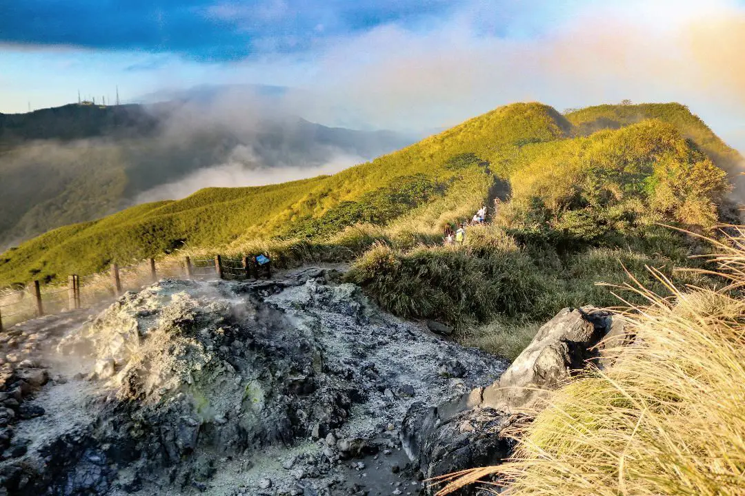
Yangmingshan National Park is a mountainous area in Taipei and New Taipei, known for its volcanic activity, hiking trails, wildlife, waterfalls, hot springs, and sulfur vents. It is definitely worth a stop on your trip to Taipei.
Historical Background: The area known as Yangmingshan now was formed by volcanoes about 700,000 years ago, forming many mountains about 1000 meters or less in northwestern Taiwan. The park still features active volcanoes, vents, and hot springs. The original name of the area was Caoshan (grass mountain 草山). During the Qing Dynasty, the area was used to harvest sulfur, and many of the hills were burned to help catch sulfur thieves, Qingtiangang likely being one of these areas. Sulfur mining was started in the Qing Dynasty by a British mining company that first obtained the rights to mine here in 1897. In 1927 during the Japanese era, Yangmingshan was made as the first national park in Taiwan, then known as Datunshan National Park Association. The area around Qingtiangang to Lengshuikeng was made into a ranch for water buffalo, and grass from Japan was planted here for them to graze. In 1950 after the ROC took Taiwan, Chiang Kai-shek renamed the park after the philosopher Wang Yangming, and called the area Yangmingshan. The KMT kept the ranch at Qingtiangang and continued to maintain it. They also built bunkers here and kept a garrison of troops. In 1985, after resolving many land disputes, Yangmingshan National Park was officially designated as a national park in the ROC era. Due to its easy accessibility from Taipei and many natural attractions, it is one of the most popular tourist destinations in Taipei City. Most visitors come on weekends, and it has parking lots and visitor's centers throughout the park. Hours: The visitor's centers are open from 9 AM to 4:30 PM. However you can visit the park 24/7. Price: Free entrance into the park (car parking 30-50 NT, scooter parking 20 NT) You can book tours to Yangmingshan on TripAdvisor here, Klook here, or KKday here or here. Tours: You can check out tours to Yangmingshan such as a One-day Yangmingshan NP Beitou Hot Spring Park and Tamsui Tour Package, Beitou and Yangmingshan Day Tour from Taipei, One Day Hike around Yangmingshan, or Private Yangmingshan Volcano Tour and more on TripAdvisor here, Klook here, or KKday here. When to Go: Silver Grass Season: Mang Grass season goes from September to November. During this time you will be able to see silvery grass all over the mountain tops around the park. Cherry Blossom Season: Cherry blossoms can be seen in the park from February to late March. Snowfall: Once every few years it can snow here from December to February. The snow usually only lasts a day or two and melts away quickly. Best Weather: In my opinion, the best weather is in the summer when constant rain makes the air cleaner, and summer mornings are usually clear. Be sure to start hiking in the morning for the best views and sunshine, as afternoon thundershowers are common. Hotels in Taipei: High end: We have stayed at and recommend the Yuanshan Grand Hotel, once the tallest building in Taiwan and still the most grand (book on Booking.com here, Tripadvisor here, or Agoda here). We have also stayed at and recommend the Grand Hyatt (book on Booking.com here, Tripadvisor here, Agoda here, or Hotels.com here), Marriot (book on Booking.com here, Tripadvisor here, Agoda here, or Hotels.com here), Sheraton (book on Booking.com here, Tripadvisor here, Agoda here, or Hotels.com here), Shangri-la (book on Booking.com here, Tripadvisor here, Agoda here, or Hotels.com here), and Regent (book on Booking.com here, Tripadvisor here, Agoda here, or Hotels.com here), which are all very high quality hotels in the middle of Taipei City. We also recommend Fullon Hotel which has locations in Tamsui and Fulong near the beach (book on Booking.com here, Tripadvisor here, Agoda here, or Hotels.com here). Budget Hotels: We have stayed at and also recommend Fu Chang Hotel in Ximending, which is within walking distance of Ximending shopping district (book on Booking.com here, Tripadvisor here, or Agoda here). We have also stayed at and recommend Hai Xia Your Home which is right in front of Fulong Beach (book on Booking.com here, Tripadvisor here, Agoda here, or Hotels.com here). Looking for a hotel? We recommend booking through Booking.com here, which provides the best quality selection of accommodation in Taiwan. Find out where to stay in our Taiwan hotels guide or search for the best hotel deals in Taiwan here. How to get there: By Car/Scooter: From Taipei, take provincial highway 2A north to the park, where you can see the main attractions such as Zhuzihu, Qixingshan, Datunshan, Qingtiangang, etc. There are many parking lots, but car parking is limited on weekends and the number of cars allowed up the mountain is also limited. There is also paid scooter parking. On weekends this place can be packed, and cars can be backed up for up to an hour or more, so consider taking a scooter or bus. Looking for scooter rental in Taipei? Check out Qeeq here, Klook here, or KKday here to search for options. You can also check out our scooter rental guide here. If you are looking for car rentals, you can also search Qeeq here, Klook here, or KKday here. You can also check out our car rental guide here. By Bus: From Beitou MRT Station, Take Little Bus 19 (小19), or another bus to the park. You can book tickets to travel to Taipei via inter-city bus on Klook here. You can book tickets to Taipei via high speed rail (HSR) on Klook here or KKDay here. By Bicycle: Cycling is the best way to enjoy Taiwan's landscapes if you have the time and energy. Looking for bicycle rentals in Taiwan? You can search on KKday here and search for tours on Klook here. You can also check out our Taiwan cycling guide here. Map: See below for a map of places mentioned in this blog: 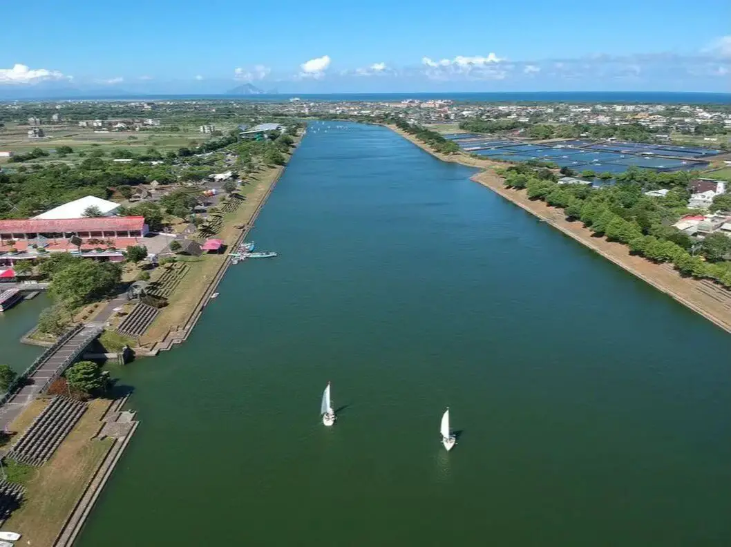
Yilan is a gem on Taiwan's northeast coast. It has rugged mountains, waterfalls, a flat coastal plain, a volcanic island, hot springs, and some of the best beaches in Taiwan. In addition you can find night markets, seafood markets, museums, and much more to explore here. It is definitely worth a stop on your next trip to Taiwan.
Historical Background of Yilan: Before Chinese settlers came, the area around Yilan was inhabited by the Ketagalan Aboriginal tribe, whose language is now extinct. The name Yilan comes from this language. The town Toucheng literally means "first town" in Chinese, because it was the first settlement in Yilan, settled in the late 1700s. With the nearby Wushih and Touwei Harbors around the same time, it became the economic focal point of Yilan. However, in the late 1800s and early 1900s Wushih Harbor and Touwei Harbor silted in, reducing their function. With the advent of the Japanese-built Yilan railway line in the mid-1900's, as well as constant floods and continual silting of the harbors, Toucheng Old Street quickly lost its importance economically and fell into decay. The Japanese also built logging railways up to Taipingshan to harvest lumber. The first path between Yilan and Hualien was a trail built in the Qing Dynasty that was completed in 1876, in order for the Qing to better control aboriginal peoples on the east coast. Later after Japan took control of Taiwan, they widened the path and built 9 bridges and 14 tunnels along the way, making it drivable for cars (one way only) by 1932. Because much of the road was next to cliffs that underwent constant landslides, it was considered one of the most dangerous roads in the world at the time. In the 1980s the ROC government further widened the road, and the two-lane highway was completed in 1990. In 2020, the section of road between Su'ao and Dong'ao was bypassed by a tunnel. Currently Yilan has a population of over 450,000. An High-Speed Rail extension is planned for Yilan, and is expected to be completed by 2036. When to go? The best weather in Yilan lasts from about March-November. During winter months there is constant rain due to the northeasterly winds. How get to Yilan? You can book tickets to travel to Yilan via inter-city bus on Klook here. You can book tickets to Yialn via high speed rail (HSR) on Klook here or KKDay here. Book tickets via the normal train (TRA) on Klook here. How to get around in Yilan? As always, we recommend renting a scooter as the best way to see Taiwan. However, you can also a great deal of Yilan by taking the TRA train, inter-city bus, or local bus. Getting around in a car is also a convenient option as there is plenty of parking pretty much everywhere in this less crowded county. Scooter Rental: Looking for scooter rental in Yilan? You can search Klook here or KKday here to look for options. You can also check out our scooter rental guide here. Car Rental: If you are looking for car rentals in Yilan, you can also search Klook here or KKDay here. You can also check out our car rental guide here. Bicycle Rental: Cycling is the best way to enjoy Taiwan's landscapes if you have the time and energy. Looking for bicycle rentals in Taiwan? You can search on KKday here and search for tours on Klook here. You can also check out our Taiwan cycling guide here. Tours and Activities: You can purchase tours and tickets for many activities in Yilan such as Su'ao Crayon Castle, Taipingshan, Turtle Island, International Children's Festival, Lanyang Museum, Toucheng Leisure Farm, Zhang Mei Ama Capybura Farm, Bambi Land, Yinong Ranch, National Center for Traditional Arts, Taxi Museum, Glamping, Camping, ATV / 4-wheeling experience, SUP / paddle boarding, Ximeng Forest Theater, Surfing, Kayaking, Horse Riding, River Tracing, River Rafting, River Tubing, Pack Rafting, Water Biking, Snorkeling, Canoeing, Shrimping and many others through Klook here or KKday here. Accommodation: We have stayed at and recommend Ying Shih Guest House, a resort in Datong Township near Taipingshan and Fan Fan Hot Spring (you can book on Agoda here or Booking.com here), and Jiaosi Hotspring Hotel, a hotel with hot springs in each room (you can book on Agoda here, Booking.com here, Hotels.com here, Expedia here, or Trip.com here). We have also stayed at Toucheng Leisure Farm, a recreational farm and experience center in Toucheng (you can book on Agoda here, Booking.com here, Hotels.com here, Expedia here, on Klook here, or on Trip.com here). We recommend booking through Agoda here, which provides the best quality selection of accommodation on the islands. Find out where to stay in our Taiwan hotels guide or search for the best hotel deals in Taiwan here. You can also book Wifi and SIM cards for Taiwan on Gigago here. Need travel insurance? Compare prices on Insubuy here. Just to let you know, if you book using the links above, we get some commission at no cost to you, and you can help support our blog. You can click here to receive $5 USD on your first Klook purchase. Map: You can find a map of places we will cover in this blog below: 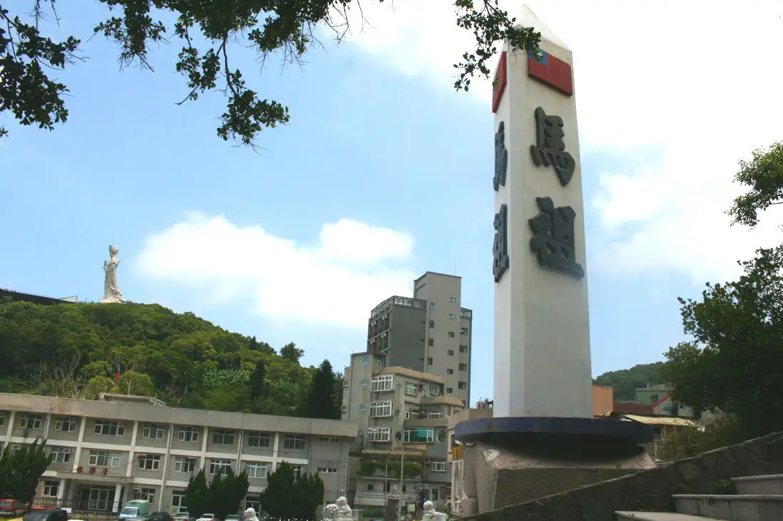
The Matsu Archipelago is a group of small islands off the coast of China that belong to Taiwan. Acting for a long time as military outposts for Taiwan, the islands have recently opened to tourists. Here you can find traditional stone house villages, magical "blue tear" bioluminescent phenomena, wild sika deer, military museums, a Mazu memorial park including the largest Mazu statue in the world, a variety of local food, and much more to explore.
Background: Thousands of years ago, stone aged peoples once inhabited the Matsu Islands. These stone aged people later disappeared. The Matsu islands were inhabited again around the Song Dynasty (990 - 1200 AD) by Chinese fisherman, the descendants of whom still inhabit the islands today. Because the Goddess Mazu's corpse washed ashore on this island, Nangan is also known as Matsu Island. During the Chinese Civil War, Matsu was used as a military outpost for the retreating ROC. During the years that followed, it withheld shelling and threats of invasion from China, helping to keep Taiwan free of communist control. In 1992 after cross-strait relations had warmed up, martial law was lifted on the islands and tourists were allowed to visit. In the year 2000, a ferry link with Fuzhou started to provide constant China Mainland visitors to the island, as part of the three links with China. In 1994 Beigan Airport was opened and was the only airport in Matsu for 9 years. In 2003, the Nangan Airport was opened, which significantly lowered the number of travelers to Beigan. However fast and convenient boat travel has made it so that most tourists travel to both islands. Matsu (or officially Lienchiang County of Fujian Province 連江縣) consists of 36 islands or islets, with 5 major islands: Nangan, Beigan, Xiju, Dongju, and Dongyin, and minor islands including Daqiu, Xiaoqiu, Gaodeng, and Liangdao. Nangan has a population of 4,000 people and is the largest island in Matsu in terms of population and geographical size. Beigan Island is the second largest island in Matsu (behind Nangan), and has a population of about 2,500. Xiju and Dongju Islands sit next to each other and have a combined population of 1,500 people. Dongyin is the third largest island in terms of size and population, with about 1,300 people. Daqiu is a small island near Beigan with a population of 1 human and about 300 wild sika deer. Xiaoqiu is another small uninhabited rocky islet next to Daqiu. Gaodeng Island and Liangdao Islands are also sizable islands in the chain but are military islands that are currently closed off to tourists. How to get there: The easiest way to get around the islands is to take a plane from Songshan Airport or by boat from Taipei or Keelung Nangan and then go island hopping from there. Nangan is the main transportation hub for all the islands. You can book flights to Matsu on Trip.com or CheapO Air. You can also search for cheap flights in Taiwan on Kiwi here. You can book ferry tickets to Matsu on KKday here. Dongyin Island: By Boat: There are daily ferries from Keelung Harbor that usually take an overnight trip to Nangan, passing through Dongyin Island. The price for a one-way ride is 400-2000 NT depending on the type of accommodation you want on the boat. Boats from Nangan leave twice a day and take 2 hours. The price for a one-way ride is 350 NT. Beigan Island: By Boat: There are boats from Nangan Fu'Ao Harbor (南竿福奧港) to Beigan Baisha Harbor (北竿白沙港) every hour from 7 AM to 5 PM. There are no daily routes to Beigan from other islands (except Daqiu). You can book tickets between Nangan and Beigan Islands on KKday here. By Plane: There are flights to and from Taipei Songshan Airport three times a day via Uni Air. You can book flights on KKday here, Trip.com here, CheapO Air here, or Kiwi here. Daiqu Island: Public Ferry from Nangan Fu'Ao Harbor (福澳港) (April to October): 350 NT round trip per person (Stops at Baisha Harbor in Nangan) Nangan departure times: 9:50 AM, 1:30 PM, Daqiu departure times: 12:10 Noon, 3:40 PM Trip takes about 20 minutes. You can book a ferry to Daqiu Island on KKday here. Public Ferry from Beigan Qiaozi Harbor (橋仔港) (May to October): 300 NT round trip per person Beigan departure times: 8:30 AM, 2:30 PM, Daqiu departure times: 10:30 AM, 4:30 PM https://hotels.matsu.idv.tw/ferry.php Trip takes about 10 minutes. Chartered ferries: Around 300 NT per round trip. You can book tickets between Nangan and Beigan Islands on KKday here. Nangan Island: By Boat: There are daily ferries from Taipei or Keelung that usually take an overnight trip to Nangan, passing through Dongyin Island. There are boats from Beigan Baisha Harbor (北竿白沙港) to Nangan Fu'Ao Harbor (南竿福奧港) every hour from 7 AM to 5 PM. You can book tickets between Nangan and Beigan Islands on KKday here. By Plane: There are flights to and from Taipei Songshan Airport three times a day via Uni Air. You can book flights on KKday here, Trip.com here, CheapO Air here, or Kiwi here. Dongju and Xiju Islands: By Boat: Ferries from Nangan leave every 3 hours, with three trips per day. The trip takes about an hour. Price is 200 NT one way. Price (to Nangan): By Boat: 500-2000 NT per person (one way from Taipei or Keelung) 160 NT per person (one way from Beigan) By Plane: About 2000 NT (one way from Taipei). There are flights to and from Taipei Songshan Airport three times a day via Uni Air. You can book flights on KKday here, Trip.com here, CheapO Air here, or Kiwi here. How to get around the islands: Matsu has large, hilly islands and it would be very hard to get around on foot or bicycle. We recommend one of the following. By Ferries: The only way to get to smaller islands without airports is by ferry. You can check KKday here for ferry tickets or buy them at the harbor. By Scooter: We recommend riding a scooter as your #1 choice. It's fast, convenient, and there isn't much traffic on the island. A scooter will cost about 500 NT per day to rent. You can rent a scooter on Klook here or KKday here. When braking on hills, use both brakes, otherwise, you could lose traction on one tire and skid. Don't stop or park on a slope. Also, some hills that are too steep are closed off for scooters. You can also check out our scooter rental guide here. By Car/Taxi: You can rent a car or hire a taxi for 200O NT per day. If you are looking for car rentals, you can also search Qeeq here, Klook here, or KKday here. You can also check out our car rental guide here. By Bus: There are buses that go around the islands, but wait times can be 30 minutes or more. By Bicycle: Cycling is the best way to enjoy Taiwan's landscapes if you have the time and energy. Looking for bicycle rentals in Taiwan? You can search on KKday here and search for tours on Klook here. You can also check out our Taiwan cycling guide here. Hotels: We have stayed at and recommend Fu Hwa Homestay on Nangan (you can book on Agoda here, Booking,com here, or Trip.com here), and B&B of Blueshine on Beigan (you can book on Agoda here, Booking,com here, or Trip.com here). Both places were excellent, and provided us a car ride to and from the airport for free. You can also check out our Taiwan hotels guide here. Looking for a hotel? We recommend booking through Agoda here, which provides the best quality selection of accommodation on the island. You can also book Wifi and SIM cards for Taiwan on Gigago here. Need travel insurance? Compare prices on Insubuy here. When to go: We recommend going between April and June when the "blue tear" phosphorescent microbes in the water will be the most visible at night. Also, winters can be cold and windy, and summers very hot, and there could also be typhoons in the summer and fall. Tours and Activities: Beihai Tunnel Rocking Boat: about 150 NT Blue Tears Museum: about 300 NT SUP/Paddle experience: about 2300 NT You can search for other tours and activities on KKday here or Klook here. Just to let you know, if you book using the links above, we get some commission at no cost to you, and you can help support our blog. You can click here to receive $5 USD on your first Klook purchase. Map: Please see below: 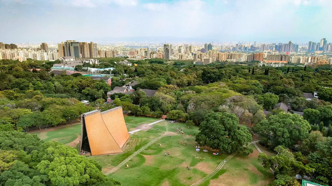
Taichung is the second largest city in Taiwan, and includes a vibrant city, delicious food, amazing coastline, and dazzling mountains. In addition, Taichung's central location in Taiwan makes it easy to visit other nearby counties. In this blog, we will show you some of the most worthwhile sites to see on your next trip to Taichung.
When to visit: It is best to visit from April to November when the weather is warm and less windy. There is a constant, cold wind from December to March especially along the coast. However, the winter in general is more dry. Where to stay: Most of the accommodation you will find is near the city center. If you will only visit downtown, you can consider a day trip from Taipei. We have stayed at and recommend the Norway Forest Travel Hotel, a convenient hotel right in front of Taichung Station (you can book on Booking.com here, Agoda here, or compare prices on Kayak here), and Sin Fu Business Hotel which is also a great value for the money and great quality in downtown Taichung (you can book on Agoda here or compare prices on Kayak here). Looking for a hotel? We recommend booking through Booking.com here, which provides the best quality selection of accommodation in Taiwan. Find out where to stay in our Taiwan hotels guide or search for the best hotel deals in Taiwan here. Basic Taichung Travel Tips:
How get to Taichung? You can book tickets to travel to Taichung via inter-city bus on Klook here. You can book tickets to Taichung via high speed rail (HSR) on Klook here or KKDay here. Book tickets via the normal train (TRA) on Klook here. How to get around in Taichung: As always, we recommend renting a scooter as the best way to see Taiwan. However, you can also a great deal of Hsinchu by taking the train, inter-city bus, or local bus. Getting around in a car is also a convenient option as there is plenty of parking pretty much everywhere in this less crowded county. Scooter Rental: Looking for scooter rental in Taichung? You can search Klook here or KKday here to look for options. You can also check out our scooter rental guide here. Car Rental: If you are looking for car rentals in Taichung, you can also search Qeeq here, Klook here, or KKDay here. You can also charter a car on KKday here. You can also check out our car rental guide here. By Bus: You can book a Taichung sightseeing bus on KKday here. By Bicycle: Cycling is the best way to enjoy Taiwan's landscapes if you have the time and energy. Looking for bicycle rentals in Taiwan? You can search on KKday here and Klook here. You can also check out our Taiwan cycling guide here. For more information, check out our Taiwan transportation guide here. Tours: There are many tours of Taichung available on on KKday here or Klook here, such as an Instagram Day Tour, Historic Downtown and Sun Cake DIY Experience, Taichung Railway Station Walking Tour, Local Market Biking Tour, Aboriginal Food Tour, and much more on KKday here or Klook here. Attractions: There are many amazing sites and attractions in Taichung, such as Gaomei Wetlands, Rainbow Village, Luce Chapel, Rainbow Village, Wuling Farm, Nantun Old Street, Xinshe Flower Garden, Lihpao Land Theme Park, National Museum of Natural Science, Wonder New Land Children's Park, Carton King Creative Park, Jurassic Planet Park, Museum of Illusions, Lavender Cottage, Okuma Center Fishing Museum, Basian Forest Recreation Area, Wooderlife Gaming Area, Dasyueshan Recreation Area, Wufeng Lin Family Garden, Moncoeur Garden, Yukids Island, Shoe Wonderland Factory Tour, Lihpao International STS Race Circuit, Muxinquan Leisure Farm, Guguan Hot Springs, Miyahar, Fushoushan Recreational Farm, Xinshe Castle, National Taichung Theater, and many more which are covered in this blog. You can also book a Taichung pass for multiple attractions on Klook here or here. Activities: Taichung has lots of indoor and outdoor activities available, such as Scuba Cube Hotel Indoor Diving Experience, Batting Cages, Indoor Skiing and Sledding, Car Race Track, Pilot an Aircraft, Glamping, Archery, Trampoline Center, Off-road ATVing, Hiking, see cherry blossoms, stargazing, Aboriginal Food Tour, cooking class, and much more on KKday here or Klook here. Just to let you know, if you book using the links above, we get some commission at no cost to you, and you can help support our blog. You can click here to receive $5 USD on your first Klook purchase. Map: See below for a map of places we will cover in this blog: 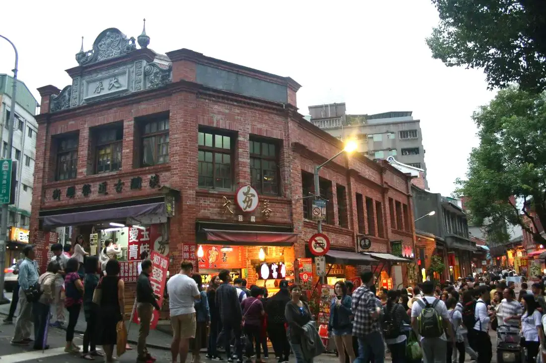
Taipei has some amazing old streets waiting to be discovered by you. Each one of the old streets around Taipei has a special story to tell that can help you understand more about Taiwan's History and Culture. In this guide, we will introduce the most popular old streets in Taipei, as well as some that are less well-known.
What is an "Old Street?" Taiwan's "old streets" can be difficult to define. There are technically "old streets" in every town in Taiwan, but what makes them famous enough to become known as the old street of the town? One can say that if there are enough historical buildings preserved in one spot, this can be considered an old street. However, sometimes old streets are put together by the local government and turned into a market or renovated historical area, or pedestrian area, with lots of stalls selling food and snacks and attracting lots of tourists. This is the kind of old street that most people want to visit, but we will cover both non-touristy old streets and touristy old streets in this blog. Brief Historical Background of Taipei: The land on which Taipei now stands on what was once part of Basay tribal land. The Basay people had lived on the land for thousands of years before the first Chinese settlers ever came. Chinese settlers from Fujian began living here during the Dutch rule in the 1600s. The first Chinese settlers came to the area in the mid-1800's during the Qing Dynasty. They created a public area for drying rice and grain, called Dadaocheng (大稻埕) which also became the central market in the area. The earliest trading shops were built in 1851, mainly selling rice, sugar, camphor, and tea. Dihua Street (迪化街) was created around this time, making it the oldest street in Taipei. Most of the buildings were one story and made of red brick in Fujian style, and later western style houses were built. The walls and gates of Taipei were completed in 1884. In 1891, the first train connecting Keelung and Taipei was completed. During the Japanese era, in 1904 the walls of Taipei were destroyed after less than 30 years, and Taipei was re-planned into the capital of Taiwan. After the ROC took control of Taiwan, Taipei continued as the capital city, as well as the financial hub of Taiwan. During the Taiwan miracle, many rural families moved from southern Taiwan to factories and offices in Taipei, making Taipei the most populous urban area in Taiwan. Currently, Taipei is the most advanced and affluent city in Taiwan. It also has Taiwan's most advanced public transportation system, making it easy for millions of commuters to live outside the city where rents are cheaper. Now, most of Taiwan's economic activity is based in this city. Basic Taipei Travel Tips:
When should you go to Taipei? In my opinion, the best weather in Taipei is from March-May, and October - November, when the temperatures stay around 26 degrees Celsius and there is not as much rain. Summers are also nice, with the most sunny weather, but also hot and rainy. Winters can be cold (but not below freezing) and usually wet. Overall, there is no wrong answer as to what time of year you should visit Taipei. You will have a great time here at any time of year. Hotels in Taipei: We have stayed at and recommend the Yuanshan Grand Hotel, once the tallest building in Taiwan and still the most grand (book on Booking.com here, Agoda here, or Kayak here). We have stayed at and also recommend Fu Chang Hotel in Ximending, which is within walking distance of Ximending shopping district (book on Booking.com here, Agoda here, or Kayak here). Looking for a hotel? We recommend booking through Booking.com here, which provides the best quality selection of accommodation in Taiwan. Find out where to stay in our Taiwan hotels guide or search for the best hotel deals in Taiwan here. Tours in Taipei: There are many tour itineraries that you can enjoy in Taipei that will take you to multiple destinations and arrange transportation. For more information, you can check out KKday here or Klook here which are both great tour websites that can connect you with the right tour and tour guide for you. Attractions in Taipei: There are many attractions that you can enjoy in Taipei such as Taipei 101 Observatory, Taipei 101 460 Skyline Observatory, Taipei Children's Amusement Park, Maokong Gondola, National Palace Museum, Yehliu Ocean World, Yehliu Geopark, National Museum of Marine Science and Biology, i-ride 5D cinema, Astronomical Museum, Miniatures Museum of Taiwan, Double Decker Sightseeing Bus, Miramar Ferris Wheel Ticket, Taipei Zoo, Heping Island Park, Ju Ming Museum, Yuanshan Hotel Secret Road, National Taiwan Museum, New Taipei Gold Museum, Futian Leisure Farm, Chiang Kai-shek Shilin Residence, Chi Po-lin Museaum, Beitou Museum, Tsao Wonderland, Railway Museum, Fort San Domingo, 13 Levels Archaeology Museum, Austin Land, Museum of World Religions, Formosan Aboriginies Museum, ASE Parent-child Park, teamLab Future Park, Yukids Island, VR Experience, Bat Cave, Neidong Waterfall, Candlestick Islet, Jurassic Snow Park, Zhonghe High5 Amusement Park, Longshan Temple, Xingtian Temple, Ningxia Night Market, Yansan Night Market, Meteor Garden, Yingge Old Street, and many more attractions on Klook here or KKday here. Activities in Taipei: Indoor Skiing, Rock Climbing, Hiking, Wakeboarding, Surfing, Speedboat Surfing, SUP / Paddle Boarding, Diving, Snorkeling Kayaking, Canoeing, Water Biking, River Tracing / Canyoneering, ATVing, Horse Riding, Cooking Class, Archery, Ice Skating, Roller Skating, Tree Climbing, Urban Camping, Glamping, Motorcycling, Motorbike Tour, Dragon Boat Racing, Escape Room, Shen'ao Rail Bike, Laser Gun Experience, Batting Cages, Bowling, Paintball, Flight Simulation Experience, Taipei Tram Driving Experience, Rail Simulation Experience, Taipei 101 Observation Deck activity, Strawberry Picking, Professional Photo Shoot, Body Relaxation SPA, Night Tour, Calligraphy Workshop and more on Klook here or KKday here. Just to let you know, if you book using the links above, we get some commission at no cost to you, and you can help support our blog. Some of the Klook links may not work if you are using an Ad blocker. You can click here to receive $5 USD on your first Klook purchase. How to get there: The only way to get to Taiwan is via airplane. Planes leave daily from Taipei's Songshan and Toayuan Airport. Taoyuan Airport: Taoyuan is Taiwan's largest airport and typically has cheaper flights and more flight times to choose from. It's about an hour's journey from Taoyuan Airport to the center of Taipei. You can travel via MRT, HSR, bus, or taxi to get to Taipei. You can get 30% off the Taoyuan Airport VIP lounge on KKday here. Songshan Airport: Songshan is a small airport in Taipei's city center, and can be a convenient option for people traveling within Asia. The airport is right on the Taipei MRT brown line. You can book cheap flights to Taiwan on KKday here, Trip.com here, CheapO Air here, or Kiwi here. How to get around in Taipei: Taipei's transportation system is convenient and safe. There are many options you can consider to get around in Taipei below: By Train: Gets you to the city center of all major cities in Taiwan. It is about 800NT to get from Taipei to Kaohsiung. Roughly half the price of the HSR. Book tickets via the normal train (TRA) on Klook here. By HSR: (High-Speed Rail) – Gets you quickly from north to south. Besides Taipei and Kaohsiung, most of the stations are far from city centers. It costs about 1500NT to get from Taipei to Kaohsiung. You can book tickets to the high-speed rail (HSR) on Klook here or KKDay here. By MRT: (Mass Rapid Transit, Metro train, subway) – Easily gets you around Taipei and Kaohsiung. You can also book an MRT travel pass on Klook here. By Bus: Buses can be tricky. Long-range buses such as Ubus and King Bus are easier to understand and cheaper than the local train. They can take you to the city center of every city throughout Taiwan and to remote tourist destinations such as sun moon lake. A long-range bus from Taipei to Kaohsiung is about 500 NT. You can also book tickets to travel to Shifen via inter-city bus on Klook here. By Taxi: You can take short rides for about 150 NT, or hire a Taxi for a day for around 150 USD. By Car: If you are looking for car rentals, you can also search Qeeq here, Klook here, or KKday here. You can also check out our car rental guide here. By Scooter: Looking for scooter rental in Taipei? Click here or here to search for options. You can also check out our scooter rental guide here. By Bicycle: Cycling is the best way to enjoy Taiwan's landscapes if you have the time and energy. Looking for bicycle rentals in Taiwan? You can use Taiwan's many Youbike bike sharing stations, or search for rentals on KKday here, and search for tours on Klook here. You can also check out our Taiwan cycling guide here. For more information, check out our Taiwan transportation guide here. Tourist Site Map: Check out our map below of tourist sites in Taiwan, which is constantly updated: 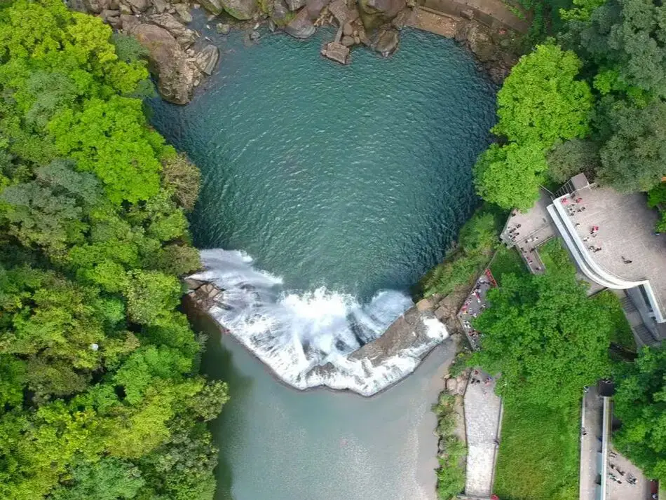
Taipei is home to some of Taiwan's most magnificent waterfalls, and most of them are just a short trip away. Here we have compiled a list of the most easily accessible waterfalls around Taipei.
Please note this is not an exhaustive list. There are many more waterfalls in Taipei than are listed in this blog. Get out there and discover Taipei's waterfalls for yourself! Safety Tips When Visiting Waterfalls:
Basic Taipei Travel Tips:
When should you go to Taipei? In my opinion, the best weather in Taipei is from March-May, and October - November, when the temperatures stay around 26 degrees Celsius and there is not as much rain. Summers are also nice, with the most sunny weather, but also hot and rainy. Winters can be cold (but not below freezing) and usually wet. Overall, there is no wrong answer as to what time of year you should visit Taipei. You will have a great time here at any time of year. Hotels in Taipei: We have stayed at and recommend the Yuanshan Grand Hotel, once the tallest building in Taiwan and still the most grand (book on Booking.com here, Agoda here, or Kayak here). We also recommend Fullon Hotel which has locations in Tamsui and Fulong near the beach (book on Booking.com here, Agoda here, or Kayak here). Budget Hotels: We have stayed at and also recommend Fu Chang Hotel in Ximending, which is within walking distance of Ximending shopping district (book on Booking.com here, Agoda here, or Kayak here). We have also stayed at and recommend Hai Xia Your Home which is right in front of Fulong Beach (book on Booking.com here, Agoda here, or Kayak here). Looking for a hotel? We recommend booking through Booking.com here, which provides the best quality selection of accommodation in Taiwan. Find out where to stay in our Taiwan hotels guide or search for the best hotel deals in Taiwan here. Tours in Taipei: There are many tour itineraries that you can enjoy in Taipei that will take you to multiple destinations and arrange transportation. For more information, you can check out KKday here or Klook here. Attractions in Taipei: There are many attractions that you can enjoy in Taipei such as Taipei 101 Observatory, Taipei 101 460 Skyline Observatory, Taipei Children's Amusement Park, Maokong Gondola, National Palace Museum and many more attractions on Klook here or KKday here. Activities in Taipei: You can also look for more activities in Taipei such as Rock Climbing, Surfing, Speedboat Surfing, Diving, Snorkeling, Cooking Class, Glamping, Motorcycling, and more on Klook here or KKday here. Just to let you know, if you book using the links above, we get some commission at no cost to you, and you can help support our blog. Some of the Klook links may not work if you are using an Ad blocker. You can click here to receive $5 USD on your first Klook purchase. How to get there: The only way to get to Taiwan is via airplane. Planes leave daily from Taipei's Songshan and Toayuan Airport. Taoyuan Airport: Taoyuan is Taiwan's largest airport and typically has cheaper flights and more flight times to choose from. It's about an hour's journey from Taoyuan Airport to the center of Taipei. You can travel via MRT, HSR, bus, or taxi to get to Taipei. You can get 30% off the Taoyuan Airport VIP lounge on KKday here. Songshan Airport: Songshan is a small airport in Taipei's city center, and can be a convenient option for people traveling within Asia. The airport is right on the Taipei MRT brown line. You can book cheap flights to Taiwan on KKday here, Trip.com here, CheapO Air here, or Kiwi here. How to get around in Taipei: Taipei's transportation system is convenient and safe. There are many options you can consider to get around in Taipei below: By Train: Gets you to the city center of all major cities in Taiwan. It is about 800NT to get from Taipei to Kaohsiung. Roughly half the price of the HSR. Book tickets via the normal train (TRA) on Klook here. By HSR: (High-Speed Rail) – Gets you quickly from north to south. Besides Taipei and Kaohsiung, most of the stations are far from city centers. It costs about 1500NT to get from Taipei to Kaohsiung. You can book tickets to the high-speed rail (HSR) on Klook here or KKDay here. By MRT: (Mass Rapid Transit, Metro train, subway) – Easily gets you around Taipei and Kaohsiung. You can also book an MRT travel pass on Klook here. By Bus: Buses can be tricky. Long-range buses such as Ubus and King Bus are easier to understand and cheaper than the local train. They can take you to the city center of every city throughout Taiwan and to remote tourist destinations such as sun moon lake. A long-range bus from Taipei to Kaohsiung is about 500 NT. You can also book tickets to travel to Shifen via inter-city bus on Klook here. By Taxi: You can take short rides for about 150 NT, or hire a Taxi for a day for around 150 USD. By Car: If you are looking for car rentals, you can also search Qeeq here, Klook here, or KKday here. You can also check out our car rental guide here. By Scooter: Looking for scooter rental in Taipei? Click here or here to search for options. You can also check out our scooter rental guide here. By Bicycle: Cycling is the best way to enjoy Taiwan's landscapes if you have the time and energy. Looking for bicycle rentals in Taiwan? You can use Taiwan's many Youbike bike sharing stations, or search for rentals on KKday here, and search for tours on Klook here. You can also check out our Taiwan cycling guide here. For more information, check out our Taiwan transportation guide here. Tourist Site Map: Check out our map below of tourist sites in Taiwan, which is constantly updated: 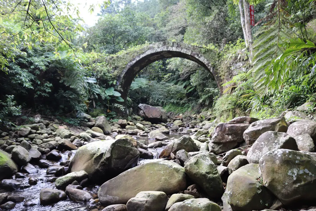
Shiding District is a secret mountain paradise in New Taipei City, in northern Taiwan (新北市石碇區). Lots of people simply pass through here without knowing much about what there is to see. In this guide I will show you some of the secret historical and nature destinations in this amazing place.
Historical Background: The name Shiding comes from boats transporting goods from the area that used to use large rocks (shi 石) in the river as anchors (ding 碇). The Shiding administrative area (石碇堡) was created during the Qing Dynasty and extended from Keelung to Wenshan District. The area around Shiding Old Street was the first area to be developed by Han Chinese in Shiding. In the early days during the Qing Dynasty, the Han Chinese settlers here mainly grew tea and leeks. During the Qing Dynasty, Shiding was an important stop along the Danlan Old Trail (淡蘭古道 which means the road between Tamsui and Yilan), which was split into three paths, and Shiding was on the Southern Path. The Southern Path winded from Mengjia Old Street to Liuzhangli, then to Shengkeng, and onto Shiding which was a major tea producer at the time. From Shiding, the road then went to Pinglin and then Yilan. The Southern path was the quickest way to Yilan. During the Japanese Era until the 1980s, the major industry in the area was coal mining, As the coal mining industry winded down in the 1980s and 90s in Taiwan due to lower worldwide coal prices, the economy in Shiding suffered and many people left. The multi story buildings near Shiding Old street are a testament to the economic prosperity of the coal mining era. Currently Shiding is sparsely populated with the main economic activity including tea farming and agriculture. Tours of Shiding: You can book a tour to Shiding on TripAdvisor here, Klook here, or KKday here. Hotels in Taipei: We have stayed at and recommend the Yuanshan Grand Hotel, once the tallest building in Taiwan and still the most grand (book on Booking.com here, Tripadvisor here, or Agoda here). We have stayed at and also recommend Fu Chang Hotel in Ximending, which is within walking distance of Ximending shopping district (book on Booking.com here, Tripadvisor here, or Agoda here). Looking for a hotel? We recommend booking through Booking.com here, which provides the best quality selection of accommodation in Taiwan. Find out where to stay in our Taiwan hotels guide or search for the best hotel deals in Taiwan here. How to get there: By Car: Go east on National Freeway 5, then get off at the Shiding interchange. Continue east until you reach Shiding Old Street. If you are looking for car rentals, you can also search Qeeq here, Klook here, or KKday here. You can also check out our car rental guide here. By Scooter: From Taipei, take highway 106 east from Shenkeng toward Shiding, pass through Shiding Bao Tunnel, and soon you will come to Shiding Old Street. Looking for scooter rental in Taipei? You can search on Klook here or KKday here to search for options. You can also check out our scooter rental guide here. By Bus: From Taipei City Call MRT station, you can take bus 912 to Shiding High School, after that you will have to switch to bus 666 which will take you all the way to the old street (total about 40 minutes). You can also book tickets to travel to Shiding via inter-city bus on Klook here. You can also book a Taipei Sightseeing: Hop On, Hop Off Open Top Bus on TripAdvisor here. By Bicycle: Cycling is the best way to enjoy Taiwan's landscapes if you have the time and energy. Looking for bicycle rentals in Taiwan? You can use Taiwan's many Youbike sharing stations, or search for rentals on KKday here, and search for tours on Klook here. You can also check out our Taiwan cycling guide here. You can also book a Sunset Riverside Bike Ride and Historical Tour, 4 Hour Cycling in Taipei, Ultimate 8-Hour Cycling City Tour, or Taipei City Bike Tour with Night Market Experience on TripAdvisor here. For more information, check out our Taiwan transportation guide here. Map: 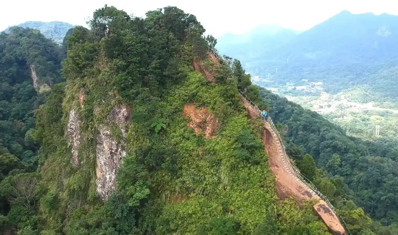
Taipei is full of very accessible hikes right next to the city center. You can find amazing views of Taipei City, as well as make some adrenaline pumping hikes up some very steep peaks in New Taipei and Keelung. We highly recommend checking out what hikes Taipei has to offer. In this guide, we will list out some of the most amazing hikes around Taipei.
Safety Tips When Hiking in Taipei:
Basic Taipei Travel Tips:
When should you go to Taipei? In my opinion, the best weather in Taipei is from March-May, and October - November, when the temperatures stay around 26 degrees Celsius and there is not as much rain. Summers are also nice, with the most sunny weather, but also hot and rainy. Winters can be cold (but not below freezing) and usually wet. Overall, there is no wrong answer as to what time of year you should visit Taipei. You will have a great time here at any time of year. Hotels in Taipei: High end: We have stayed at and recommend the Yuanshan Grand Hotel, once the tallest building in Taiwan and still the most grand (book on Booking.com here, Tripadvisor here, or Agoda here). We have also stayed at and recommend the Grand Hyatt (book on Booking.com here, Tripadvisor here, Agoda here, or Hotels.com here), Marriot (book on Booking.com here, Tripadvisor here, Agoda here, or Hotels.com here), Sheraton (book on Booking.com here, Tripadvisor here, Agoda here, or Hotels.com here), Shangri-la (book on Booking.com here, Tripadvisor here, Agoda here, or Hotels.com here), and Regent (book on Booking.com here, Tripadvisor here, Agoda here, or Hotels.com here), which are all very high quality hotels in the middle of Taipei City. We also recommend Fullon Hotel which has locations in Tamsui and Fulong near the beach (book on Booking.com here, Tripadvisor here, Agoda here, or Hotels.com here). Budget Hotels: We have stayed at and recommend and also Fu Chang Hotel in Ximending, which is within walking distance of Ximending shopping district (book on Booking.com here, Tripadvisor here, or Agoda here). We have also stayed at and recommend Hai Xia Your Home which is right in front of Fulong Beach (book on Booking.com here, Tripadvisor here, Agoda here, or Hotels.com here). Looking for a hotel? We recommend booking through Booking.com here, which provides the best quality selection of accommodation in Taiwan. Find out where to stay in our Taiwan hotels guide or search for the best hotel deals in Taiwan here. Tours in Taipei: There are many tour itineraries that you can enjoy in Taipei that will take you to multiple destinations and arrange transportation. For more information, you can check out Tripadvisor here, KKday here or Klook here, which are both great tour websites that can connect you with the right tour and tour guide for you. Here are some of the post popular tours of Taipei on Tripadvisor:
Attractions in Taipei: There are many attractions that you can enjoy in Taipei such as Taipei 101 Observatory, Taipei 101 460 Skyline Observatory, Taipei Children's Amusement Park, Maokong Gondola, National Palace Museum, Yehliu Ocean World, Yehliu Geopark, National Museum of Marine Science and Biology, i-ride 5D cinema, Astronomical Museum, Miniatures Museum of Taiwan, Double Decker Sightseeing Bus, Miramar Ferris Wheel Ticket, Taipei Zoo, Heping Island Park, Ju Ming Museum, Yuanshan Hotel Secret Road, National Taiwan Museum, New Taipei Gold Museum, Futian Leisure Farm, Chiang Kai-shek Shilin Residence, Chi Po-lin Museaum, Beitou Museum, Tsao Wonderland, Railway Museum, Fort San Domingo, 13 Levels Archaeology Museum, Austin Land, Museum of World Religions, Formosan Aboriginies Museum, ASE Parent-child Park, teamLab Future Park, Yukids Island, VR Experience, Bat Cave, Neidong Waterfall, Candlestick Islet, Jurassic Snow Park, Zhonghe High5 Amusement Park, Longshan Temple, Xingtian Temple, Ningxia Night Market, Yansan Night Market, Meteor Garden, Yingge Old Street, and many more attractions on Tripadvisor here, Klook here, or KKday here. Activities in Taipei: Indoor Skiing, Rock Climbing, Hiking, Wakeboarding, Surfing, Speedboat Surfing, SUP / Paddle Boarding, Diving, Snorkeling Kayaking, Canoeing, Water Biking, River Tracing / Canyoneering, ATVing, Horse Riding, Cooking Class, Archery, Ice Skating, Roller Skating, Tree Climbing, Urban Camping, Glamping, Motorcycling, Motorbike Tour, Dragon Boat Racing, Escape Room, Shen'ao Rail Bike, Laser Gun Experience, Batting Cages, Bowling, Paintball, Flight Simulation Experience, Taipei Tram Driving Experience, Rail Simulation Experience, Taipei 101 Observation Deck activity, Strawberry Picking, Professional Photo Shoot, Body Relaxation SPA, Night Tour, Calligraphy Workshop rand more on Tripadvisor here, Klook here, or KKday here. Just to let you know, if you book using the links above, we get some commission at no cost to you, and you can help support our blog. Some of the Klook links may not work if you are using an Ad blocker. You can click here to receive $5 USD on your first Klook purchase. How to get there: The only way to get to Taiwan is via airplane. Planes leave daily from Taipei's Songshan and Toayuan Airport. Taoyuan Airport: Taoyuan is Taiwan's largest airport and typically has cheaper flights and more flight times to choose from. It's about an hour's journey from Taoyuan Airport to the center of Taipei. You can travel via MRT, HSR, bus, or taxi to get to Taipei. You can get 30% off the Taoyuan Airport VIP lounge on KKday here. Songshan Airport: Songshan is a small airport in Taipei's city center, and can be a convenient option for people traveling within Asia. The airport is right on the Taipei MRT brown line. You can book cheap flights to Taiwan on KKday here, Trip.com here, CheapO Air here, or Kiwi here. How to get around in Taipei: Taipei's transportation system is convenient and safe. There are many options you can consider to get around in Taipei below: By Train: Gets you to the city center of all major cities in Taiwan. It is about 800NT to get from Taipei to Kaohsiung. Roughly half the price of the HSR. Book tickets via the normal train (TRA) on Klook here. By HSR: (High-Speed Rail) – Gets you quickly from north to south. Besides Taipei and Kaohsiung, most of the stations are far from city centers. It costs about 1500NT to get from Taipei to Kaohsiung. You can book tickets to the high-speed rail (HSR) on Klook here or KKDay here. By MRT: (Mass Rapid Transit, Metro train, subway) – Easily gets you around Taipei and Kaohsiung. You can also book an MRT travel pass on Klook here. By Bus: Buses can be tricky. Long-range buses such as Ubus and King Bus are easier to understand and cheaper than the local train. They can take you to the city center of every city throughout Taiwan and to remote tourist destinations such as sun moon lake. A long-range bus from Taipei to Kaohsiung is about 500 NT. You can also book tickets to travel to Shifen via inter-city bus on Klook here. You can also book a Taipei Sightseeing: Hop On, Hop Off Open Top Bus on TripAdvisor here. By Taxi: You can take short rides for about 150 NT, or hire a Taxi for a day for around 150 USD. By Car: If you are looking for car rentals, you can also search Qeeq here, Klook here, or KKday here. You can also check out our car rental guide here. By Scooter: Looking for scooter rental in Taipei? Click here or here to search for options. You can also check out our scooter rental guide here. By Bicycle: Cycling is the best way to enjoy Taiwan's landscapes if you have the time and energy. Looking for bicycle rentals in Taiwan? You can use Taiwan's many Youbike bike sharing stations, or search for rentals on KKday here, and search for tours on Klook here. You can also check out our Taiwan cycling guide here. You can also book a Sunset Riverside Bike Ride and Historical Tour, 4 Hour Cycling in Taipei, Ultimate 8-Hour Cycling City Tour, or Taipei City Bike Tour with Night Market Experience on TripAdvisor here. For more information, check out our Taiwan transportation guide here. Tourist Site Map: Check out our map below of tourist sites in Taiwan, which is constantly updated: |
Author 作家I am an American expat who has extensive experience living, working, and traveling in Taiwan. In my day, I had to learn many things about Taiwan the hard way. But I have come to learn that Taiwan is one of the best places in the world for Foreigners to live. This blog does not represent the opinions of every foreigner in Taiwan. I am just trying to help others learn more about this beautiful country. Tutor ABC - World's No. 1 Online Platform for learning English and Chinese. Get 10% off all Tutor ABC website listed prices with promo code: FOREIGNERS10 Tutor ABC - 世界第一英語和中文線上學習平台 使用促銷代碼: FOREIGNERS10 可享有 Tutor ABC 網站上列出的所有價格 10% 的折扣 Archives 檔案
April 2024
Tutor ABC - World's No. 1 Online Platform for learning English and Chinese. Get 10% off all Tutor ABC website listed prices with promo code: FOREIGNERS10 Tutor ABC - 世界第一英語和中文線上學習平台 使用促銷代碼: FOREIGNERS10 可享有 Tutor ABC 網站上列出的所有價格 10% 的折扣 Categories
|
 RSS Feed
