
Taipei is home to some of Taiwan's most magnificent waterfalls, and most of them are just a short trip away. Here we have compiled a list of the most easily accessible waterfalls around Taipei.
Please note this is not an exhaustive list. There are many more waterfalls in Taipei than are listed in this blog. Get out there and discover Taipei's waterfalls for yourself! Safety Tips When Visiting Waterfalls:
Basic Taipei Travel Tips:
When should you go to Taipei? In my opinion, the best weather in Taipei is from March-May, and October - November, when the temperatures stay around 26 degrees Celsius and there is not as much rain. Summers are also nice, with the most sunny weather, but also hot and rainy. Winters can be cold (but not below freezing) and usually wet. Overall, there is no wrong answer as to what time of year you should visit Taipei. You will have a great time here at any time of year. Hotels in Taipei: We have stayed at and recommend the Yuanshan Grand Hotel, once the tallest building in Taiwan and still the most grand (book on Booking.com here, Agoda here, or Kayak here). We also recommend Fullon Hotel which has locations in Tamsui and Fulong near the beach (book on Booking.com here, Agoda here, or Kayak here). Budget Hotels: We have stayed at and also recommend Fu Chang Hotel in Ximending, which is within walking distance of Ximending shopping district (book on Booking.com here, Agoda here, or Kayak here). We have also stayed at and recommend Hai Xia Your Home which is right in front of Fulong Beach (book on Booking.com here, Agoda here, or Kayak here). Looking for a hotel? We recommend booking through Booking.com here, which provides the best quality selection of accommodation in Taiwan. Find out where to stay in our Taiwan hotels guide or search for the best hotel deals in Taiwan here. Tours in Taipei: There are many tour itineraries that you can enjoy in Taipei that will take you to multiple destinations and arrange transportation. For more information, you can check out KKday here or Klook here. Attractions in Taipei: There are many attractions that you can enjoy in Taipei such as Taipei 101 Observatory, Taipei 101 460 Skyline Observatory, Taipei Children's Amusement Park, Maokong Gondola, National Palace Museum and many more attractions on Klook here or KKday here. Activities in Taipei: You can also look for more activities in Taipei such as Rock Climbing, Surfing, Speedboat Surfing, Diving, Snorkeling, Cooking Class, Glamping, Motorcycling, and more on Klook here or KKday here. Just to let you know, if you book using the links above, we get some commission at no cost to you, and you can help support our blog. Some of the Klook links may not work if you are using an Ad blocker. You can click here to receive $5 USD on your first Klook purchase. How to get there: The only way to get to Taiwan is via airplane. Planes leave daily from Taipei's Songshan and Toayuan Airport. Taoyuan Airport: Taoyuan is Taiwan's largest airport and typically has cheaper flights and more flight times to choose from. It's about an hour's journey from Taoyuan Airport to the center of Taipei. You can travel via MRT, HSR, bus, or taxi to get to Taipei. You can get 30% off the Taoyuan Airport VIP lounge on KKday here. Songshan Airport: Songshan is a small airport in Taipei's city center, and can be a convenient option for people traveling within Asia. The airport is right on the Taipei MRT brown line. You can book cheap flights to Taiwan on KKday here, Trip.com here, CheapO Air here, or Kiwi here. How to get around in Taipei: Taipei's transportation system is convenient and safe. There are many options you can consider to get around in Taipei below: By Train: Gets you to the city center of all major cities in Taiwan. It is about 800NT to get from Taipei to Kaohsiung. Roughly half the price of the HSR. Book tickets via the normal train (TRA) on Klook here. By HSR: (High-Speed Rail) – Gets you quickly from north to south. Besides Taipei and Kaohsiung, most of the stations are far from city centers. It costs about 1500NT to get from Taipei to Kaohsiung. You can book tickets to the high-speed rail (HSR) on Klook here or KKDay here. By MRT: (Mass Rapid Transit, Metro train, subway) – Easily gets you around Taipei and Kaohsiung. You can also book an MRT travel pass on Klook here. By Bus: Buses can be tricky. Long-range buses such as Ubus and King Bus are easier to understand and cheaper than the local train. They can take you to the city center of every city throughout Taiwan and to remote tourist destinations such as sun moon lake. A long-range bus from Taipei to Kaohsiung is about 500 NT. You can also book tickets to travel to Shifen via inter-city bus on Klook here. By Taxi: You can take short rides for about 150 NT, or hire a Taxi for a day for around 150 USD. By Car: If you are looking for car rentals, you can also search Qeeq here, Klook here, or KKday here. You can also check out our car rental guide here. By Scooter: Looking for scooter rental in Taipei? Click here or here to search for options. You can also check out our scooter rental guide here. By Bicycle: Cycling is the best way to enjoy Taiwan's landscapes if you have the time and energy. Looking for bicycle rentals in Taiwan? You can use Taiwan's many Youbike bike sharing stations, or search for rentals on KKday here, and search for tours on Klook here. You can also check out our Taiwan cycling guide here. For more information, check out our Taiwan transportation guide here. Tourist Site Map: Check out our map below of tourist sites in Taiwan, which is constantly updated:
0 Comments
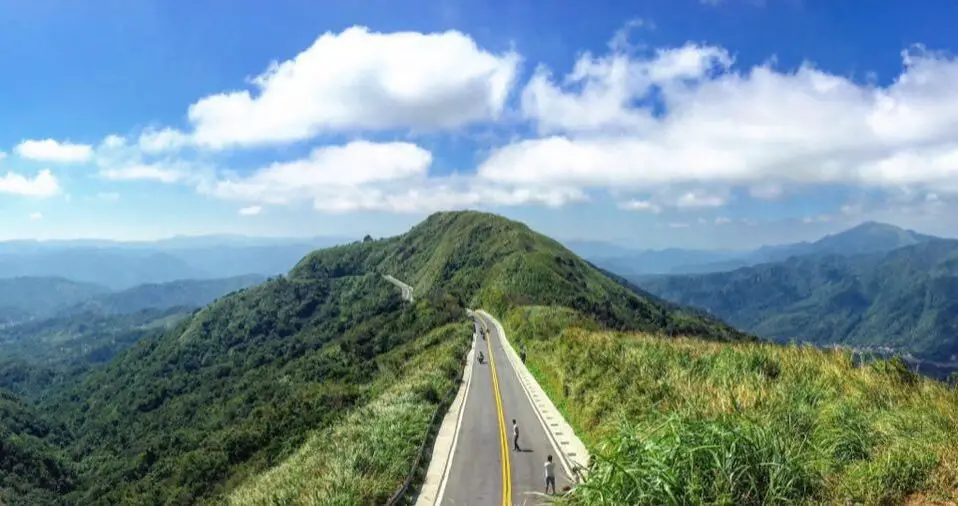
Buyanting is a viewing pavilion in Ruifang District of New Taipei, which offers amazing views of Shangxi and Ruifang Districts of New Taipei as well as Keelung City. Lately it has become a popular spot for Instagrammers to come and take dangerous photos of them standing in the middle of the road.
Background: Buyanting was built along the New Taipei City Highway 102 in 1966 (aka Ruishuang Road 瑞雙公路), at the border between Ruifang and Shuangxi. At the time, the road was the main route that connected Jiufen to Yilan, and thus connecting greater Taipei to Yilan. Later this road to Yilan was replaced by provincial highway 2, and 2A. The name Buyan Pavilion means that the views here are “not loathsome” (不厭 Buyan) so you can sit here and enjoy the views all day. The words "Buyan" are taken from a poems of the famous Tang Dynasty poet Libai. From the pavilion, you can see the ocean and Keelung Harbor, as well as the Mudan Valley, and surrounding mountains. It is a popular spot on the weekends, with many people stopping here for photos. Hours: 24/7 Price: Free Activities in Taipei: You can also look for more activities in Taipei such as Rock Climbing, Surfing, Speedboat Surfing, Diving, Snorkeling, Cooking Class, Glamping, Motorcycling, and more on Klook here or KKday here. Hotels in Taipei: We have stayed at and recommend the Yuanshan Grand Hotel, once the tallest building in Taiwan and still the most grand (book on Booking.com here, Tripadvisor here, or Agoda here). We have stayed at and also recommend Fu Chang Hotel in Ximending, which is within walking distance of Ximending shopping district (book on Booking.com here, Tripadvisor here, or Agoda here). Looking for a hotel? We recommend booking through Booking.com here, which provides the best quality selection of accommodation in Taiwan. Find out where to stay in our Taiwan hotels guide or search for the best hotel deals in Taiwan here. How to get there: By car/scooter: From Jiufen, take highway 102 south and the pavilion will be on the way to Mudan. You can also go the other way from Mudan. There is plenty of free parking on the side of the road. Looking for scooter rental in Taipei? You can search on Klook here or KKday here to search for options. You can also check out our scooter rental guide here. If you are looking for car rentals, you can also search Qeeq here, Klook here, or KKday here. You can also check out our car rental guide here. By Bus: Sadly no bus service is available here! Unless you want a really long walk. You can purchase a discount easy card to use on the MRT from Klook here or KKday here. You can also book an MRT travel pass on Klook here. By Bicycle: Cycling is the best way to enjoy Taiwan's landscapes if you have the time and energy. Looking for bicycle rentals in Taiwan? You can use Taiwan's many Youbike sharing stations, or search for rentals on KKday here, and search for tours on Klook here. You can also check out our Taiwan cycling guide here. You can also book a Sunset Riverside Bike Ride and Historical Tour, 4 Hour Cycling in Taipei, Ultimate 8-Hour Cycling City Tour, or Taipei City Bike Tour with Night Market Experience on TripAdvisor here. For more information, check out our Taiwan transportation guide here. Map: Please see below: 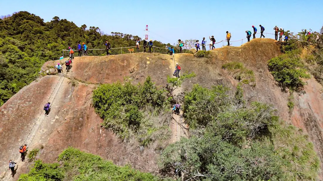
Wuliaojian in Sanxia District is one of the most popular hikes in greater Taipei. It features rope climbs, rock scrambling, and rock climbing, and has some amazing views of southern Taipei. Wuliaojian is everything but wuliao.
Background: Wuliao Jian stands at 639 meters above sea level, and the top features five peaks in the shape of a clenched fist. The climb requires ropes for some parts, and one peak called Qiaobi Xong Peak requires a 30 meter rock climb up a near sheer vertical cliff face. From the top you can enjoy views of Taipei such as Sanxia and Shulin Districts of New Taipei. Currently the hike is very popular for local people especially on the weekends. Distance: 5.5 km, Elevation gain: 530 meters Time needed: 3-5 hours When to go: Go on a sunny day when the rocks are dry, because some rock climbing is involved. Also consider going early in the morning or on a weekday, because the trails can get really clogged with crowds of people during the day on weekends. Equipment needed: Gloves because you will need to slide down lots of ropes and you do not want to get rope burn. Also bring good hiking shoes and lots of water. Tours in Taipei: There are many tour itineraries that you can enjoy in Taipei that will take you to multiple destinations and arrange transportation. For more information, you can check out Tripadvisor here, KKday here or Klook here, which are both great tour websites that can connect you with the right tour and tour guide for you. Activities in Taipei: You can also look for more activities in Taipei such as Rock Climbing, Surfing, Speedboat Surfing, Diving, Snorkeling, Cooking Class, Glamping, Motorcycling, and more on Klook here or KKday here. Hotels in Taipei: We have stayed at and recommend the Yuanshan Grand Hotel, once the tallest building in Taiwan and still the most grand (book on Booking.com here, Tripadvisor here, or Agoda here). We have stayed at and also recommend Fu Chang Hotel in Ximending, which is within walking distance of Ximending shopping district (book on Booking.com here, Tripadvisor here, or Agoda here). Looking for a hotel? We recommend booking through Booking.com here, which provides the best quality selection of accommodation in Taiwan. Find out where to stay in our Taiwan hotels guide or search for the best hotel deals in Taiwan here. How to get there: By Car/Scooter: From Sanxia Old Street, travel south on provincial highway three, and then keep left at the fork with provincial highway 7乙. The trail head is right in front of a small shop called Yuli Store (玉里商店). Looking for scooter rental in Taipei? You can search on Klook here or KKday here to search for options. You can also check out our scooter rental guide here. If you are looking for car rentals, you can also search Qeeq here, Klook here, or KKday here. You can also check out our car rental guide here. By Bus: From downtown Sanxia, take bus F627 40 minutes south to Hezuo Bridge Station, which is the start of the trailhead. You can purchase a discount easy card to use on the MRT from Klook here or KKday here. You can also book an MRT travel pass on Klook here. By Bicycle: Cycling is the best way to enjoy Taiwan's landscapes if you have the time and energy. Looking for bicycle rentals in Taiwan? You can use Taiwan's many Youbike sharing stations, or search for rentals on KKday here, and search for tours on Klook here. You can also check out our Taiwan cycling guide here. ​You can also book a Sunset Riverside Bike Ride and Historical Tour, 4 Hour Cycling in Taipei, Ultimate 8-Hour Cycling City Tour, or Taipei City Bike Tour with Night Market Experience on TripAdvisor here. For more information, check out our Taiwan transportation guide here. Map: Please see below: 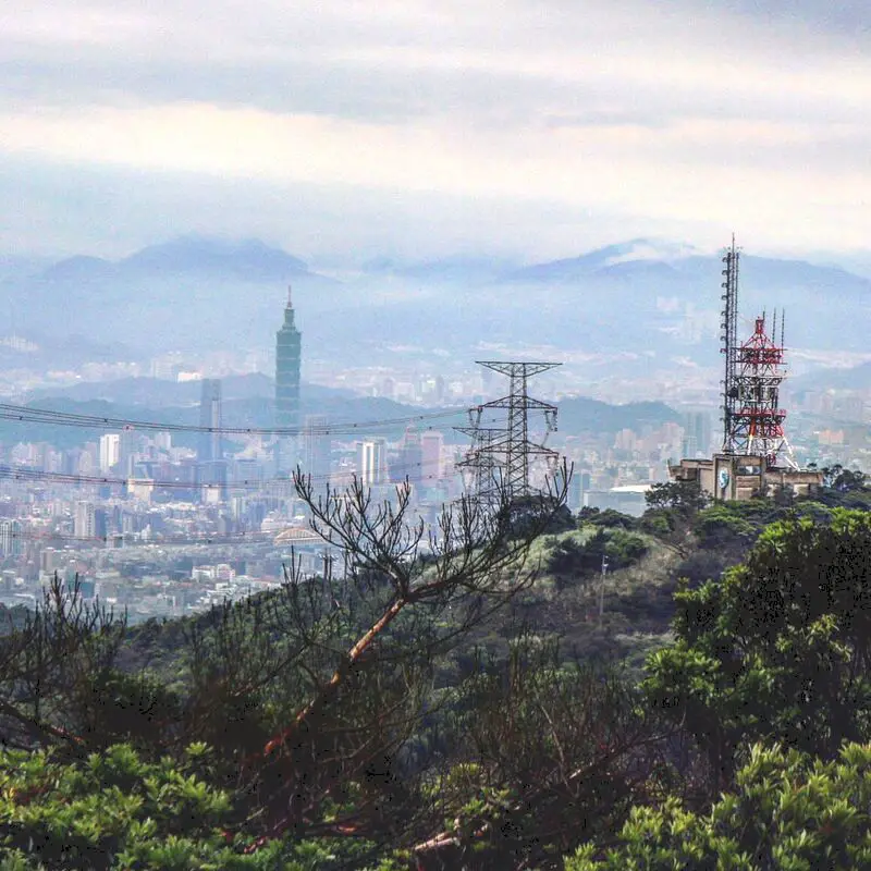
Wuzhishan is a beautiful mountain in Xizhi District of New Taipei. It is a popular place to stop for hikers, bikers, and Instagrammers due to its amazing views of east Taipei. Also there are many coffee shops here with amazing views. Besides taking photos, Wuzhishan is a great place to relax and enjoy nature.
Background: The rock formations that form Wuzhishan formed as sediment under the ocean millions of years ago, and was later uplifted thanks to the collision of the Eurasian and Philippine plates. The rocks are mainly sedimentary and are part of the same formation that forms the special rock formations on the northern coast around Keelung, and the waterfalls in Pingxi. Wuzhishan sits at 376 meters above sea level, while the bottom of the mountain is 76 meters, and the road it is 2.1 KM, making it a short, steep climb. Dream Lake get's its name from the thick fog that covers it during winter months, making it look like a dreamscape. Dream Lake is a popular spot for couples, wedding photography, and Instagram photos. Hours: 24/7 Price: Free Hike Difficulty: Moderate: About a two hour hike round trip, steep and difficult climbing through the forest with aid of ropes. Tours in Taipei: There are many tour itineraries that you can enjoy in Taipei that will take you to multiple destinations and arrange transportation. For more information, you can check out Tripadvisor here, KKday here or Klook here, which are both great tour websites that can connect you with the right tour and tour guide for you. Activities in Taipei: You can also look for more activities in Taipei such as Rock Climbing, Surfing, Speedboat Surfing, Diving, Snorkeling, Cooking Class, Glamping, Motorcycling, and more on Klook here or KKday here. Hotels in Taipei: We have stayed at and recommend the Yuanshan Grand Hotel, once the tallest building in Taiwan and still the most grand (book on Booking.com here, Tripadvisor here, or Agoda here). We have stayed at and also recommend Fu Chang Hotel in Ximending, which is within walking distance of Ximending shopping district (book on Booking.com here, Tripadvisor here, or Agoda here). Looking for a hotel? We recommend booking through Booking.com here, which provides the best quality selection of accommodation in Taiwan. Find out where to stay in our Taiwan hotels guide or search for the best hotel deals in Taiwan here. How to get there: By Car/Scooter: Take Xiwan Road (夕萬路) all the way to the top. You can also hike it starting from the Wuzhishan Old Trail trailhead. Looking for scooter rental in Taipei? You can search on Klook here or KKday here to search for options. You can also check out our scooter rental guide here. If you are looking for car rentals, you can also search Qeeq here, Klook here, or KKday here. You can also check out our car rental guide here. By Bus: Take Dongnan Bus F910 from Xizhi Park about 40 minutes up the mountain to Wuzhishan. You can purchase a discount easy card to use on the MRT from Klook here or KKday here. You can also book an MRT travel pass on Klook here. By Bicycle: Cycling is the best way to enjoy Taiwan's landscapes if you have the time and energy. Looking for bicycle rentals in Taiwan? You can use Taiwan's many Youbike sharing stations, or search for rentals on KKday here, and search for tours on Klook here. You can also check out our Taiwan cycling guide here. ​You can also book a Sunset Riverside Bike Ride and Historical Tour, 4 Hour Cycling in Taipei, Ultimate 8-Hour Cycling City Tour, or Taipei City Bike Tour with Night Market Experience on TripAdvisor here. For more information, check out our Taiwan transportation guide here. Map: Please see below: 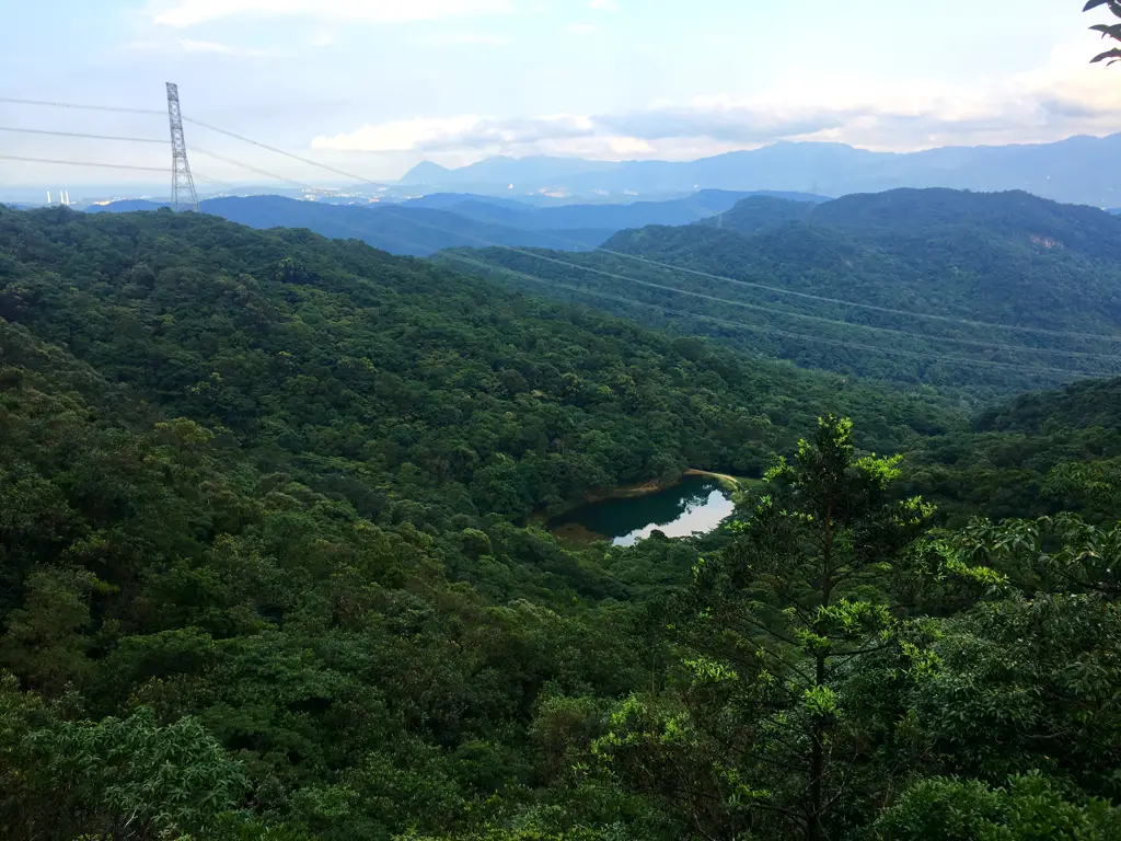
Xinshan Dream Lake (aka Xinshan Menghu) is a beautiful lake in Xizhi District of New Taipei. It is a popular place to stop for couples and Instagrammers due to its dream like aura. Also you can take the steep climb up Xinshan and enjoy some amazing views of east Taipei and Keelung. Besides taking photos, this Xinshan Dream Lake is a great place to relax and enjoy nature.
Background: The rock formations that form the Xinshan Dream lake hike formed as sediment under the ocean millions of years ago, and was later uplifted thanks to the collision of the Eurasian and Phillipine plates. The rocks are mainly sedimentary and are part of the same formation that forms the special rock formations on the northern coast around Keelung, and the waterfalls in Pingxi. Xinshan sits at 499 meters above sea level, while dream lake is 325 meters above sea level, which means the hike gains 175 meters from dream lake (in less than .5 KM), making it a short, steep hike. Dream Lake get's its name from the thick fog that covers it during winter months, making it look like a dreamscape. Dream Lake is a popular spot for couples, wedding photography, and Instagram photos. Hours: 24/7 Price: Free Hike Difficulty: Moderate: About an hour hike round trip, steep and difficult climbing through the forest with aid of ropes. Tours in Taipei: There are many tour itineraries that you can enjoy in Taipei that will take you to multiple destinations and arrange transportation. For more information, you can check out Tripadvisor here, KKday here or Klook here, which are both great tour websites that can connect you with the right tour and tour guide for you. Activities in Taipei: You can also look for more activities in Taipei such as Rock Climbing, Surfing, Speedboat Surfing, Diving, Snorkeling, Cooking Class, Glamping, Motorcycling, and more on Klook here or KKday here. Hotels in Taipei: We have stayed at and recommend the Yuanshan Grand Hotel, once the tallest building in Taiwan and still the most grand (book on Booking.com here, Tripadvisor here, or Agoda here). We have stayed at and also recommend Fu Chang Hotel in Ximending, which is within walking distance of Ximending shopping district (book on Booking.com here, Tripadvisor here, or Agoda here). Looking for a hotel? We recommend booking through Booking.com here, which provides the best quality selection of accommodation in Taiwan. Find out where to stay in our Taiwan hotels guide or search for the best hotel deals in Taiwan here. How to get there: By Car/Scooter: Take Xiwan Road (夕萬路) from Xizhi until you come to the turnoff the Xinshan Menghu on the right. It is a small one lane road up the mountain. There is scooter parking and limited car parking on the side of the road. You may need to park further down and hike up if you drive a car. The Lake trail is at the end of the road. Looking for scooter rental in Taipei? You can search on Klook here or KKday here to search for options. You can also check out our scooter rental guide here. If you are looking for car rentals, you can also search Qeeq here, Klook here, or KKday here. You can also check out our car rental guide here. By Bus: Take Dongnan Bus F910 from Xizhi Park about 40 minutes up the mountain to Xiwan Raod Bridge No. 3. From there you have to hike up to Xinshan before you come down to dream lake. Or you can get off at Menghu Intersection, but it is a long walk up the road. You can purchase a discount easy card to use on the MRT from Klook here or KKday here. You can also book an MRT travel pass on Klook here. By Bicycle: Cycling is the best way to enjoy Taiwan's landscapes if you have the time and energy. Looking for bicycle rentals in Taiwan? You can use Taiwan's many Youbike sharing stations, or search for rentals on KKday here, and search for tours on Klook here. You can also check out our Taiwan cycling guide here. ​You can also book a Sunset Riverside Bike Ride and Historical Tour, 4 Hour Cycling in Taipei, Ultimate 8-Hour Cycling City Tour, or Taipei City Bike Tour with Night Market Experience on TripAdvisor here. For more information, check out our Taiwan transportation guide here. Map: Please see below: 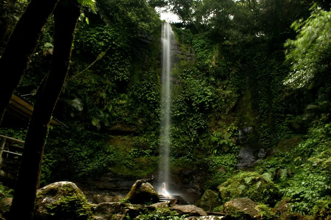
Paozilun Waterfall is a tall waterfall in Shenkeng District of New Taipei. The hike here is super easy, and there is a metal rack you can sit on to get massaged by the falling water. It is definitely a fun trip in the mountains that will not take too much time, and is part of a longer trail system through the tea fields in Shenkeng.
Background: Paozilun Waterfall is about 20 meters high, and its name comes from the Paozilun River which it is a part of. It lies on the Paozilun industrial road and can be a bit hard to find, and lies among agricultural land and tea fields. During the Qing Dynasty, the town of Shenkeng was an important stop along the Danlan Old Trail (淡蘭古道 which means the road between Tamsui and Yilan), which was split into three paths, and Shenkeng was on the Southern Path. The Southern Path winded from Mengjia Old Street to Liuzhangli, then to Shengkeng which was a major business center at the time. From Shenkeng the road then went to Shiding, Pinglin, and then Yilan. The Southern path was the quickest way to Yilan. After World War 2, the train to Yilan replaced the need for a boat dock for shipping in Shenkeng, and the town slowly fell out of importance. National Highway 3 and National highway 5 were constructed near Shenkeng in 1993 and 2006 respectively, making Shenkeng again an important stop on the way to Yilan. Currently tea is still an important crop in the mountains of Shenkeng. As for the Paozilun Trail, it is not super popular or well known and there is a good chance you will find yourself alone there on a weekend. Hours: 24/7 Price: Free Tours in Taipei: There are many tour itineraries that you can enjoy in Taipei that will take you to multiple destinations and arrange transportation. For more information, you can check out Tripadvisor here, KKday here or Klook here, which are both great tour websites that can connect you with the right tour and tour guide for you. Activities in Taipei: You can also look for more activities in Taipei such as Rock Climbing, Surfing, Speedboat Surfing, Diving, Snorkeling, Cooking Class, Glamping, Motorcycling, and more on Klook here or KKday here. Hotels in Taipei: We have stayed at and recommend the Yuanshan Grand Hotel, once the tallest building in Taiwan and still the most grand (book on Booking.com here, Tripadvisor here, or Agoda here). We have stayed at and also recommend Fu Chang Hotel in Ximending, which is within walking distance of Ximending shopping district (book on Booking.com here, Tripadvisor here, or Agoda here). Looking for a hotel? We recommend booking through Booking.com here, which provides the best quality selection of accommodation in Taiwan. Find out where to stay in our Taiwan hotels guide or search for the best hotel deals in Taiwan here. How to get there: By Car/Scooter: From Shenkeng Old Street, cross south across Highway 106 toward "Paozilun" and keep left on the road until you reach the point on the map below. There is no clear marker to the waterfall, so just follow the pictures below. There is plenty of parking on the side of the road. Looking for scooter rental in Taipei? You can search on Klook here or KKday here to search for options. You can also check out our scooter rental guide here. If you are looking for car rentals, you can also search Qeeq here, Klook here, or KKday here. You can also check out our car rental guide here. By Bus: Take bus F712 to Paozilun station, then walk a few hundred meters to the left up the hill until you reach the point on the map below. There is no clear marker to the waterfall, so just follow the pictures below. You can purchase a discount easy card to use on the MRT from Klook here or KKday here. You can also book an MRT travel pass on Klook here. By Bicycle: Cycling is the best way to enjoy Taiwan's landscapes if you have the time and energy. Looking for bicycle rentals in Taiwan? You can use Taiwan's many Youbike sharing stations, or search for rentals on KKday here, and search for tours on Klook here. You can also check out our Taiwan cycling guide here. ​You can also book a Sunset Riverside Bike Ride and Historical Tour, 4 Hour Cycling in Taipei, Ultimate 8-Hour Cycling City Tour, or Taipei City Bike Tour with Night Market Experience on TripAdvisor here. For more information, check out our Taiwan transportation guide here. Map: Please see below: 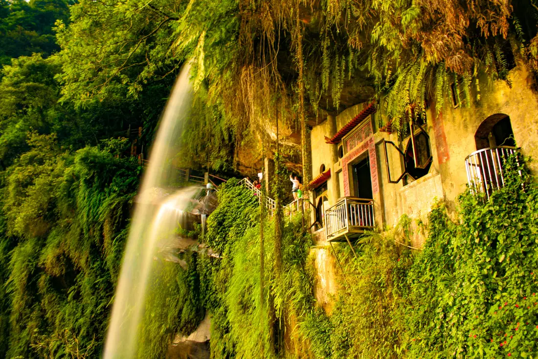
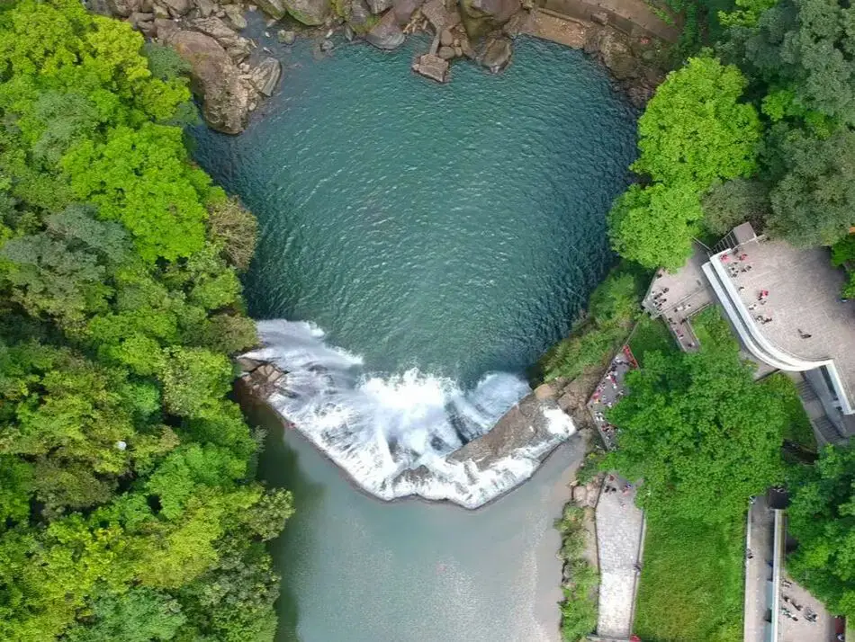
Yinhedong Waterfall (aka Yinhe Cave Waterfall) is an easily accessible sight in Xindian District of New Taipei, and perhaps the most picturesque in all of Taiwan. It is easily accessible by public transportation, and the hike takes less than ten minutes to get there from the trailhead. The waterfall includes a cave and temple that are great for taking phots. It's spectacular cascading falls are definitely worth a stop for anyone in Taiwan.
Background: Yinhedong Waterfall is about 30 meters high and is separated into two parts by a cave in the middle of the waterfall. It is located near the town of Xindian, and it's name literally means "Silver River Cave" or "Milky Way Cave." The waterfall lies a tributary of the Qingtan River which runs down tho the Xindian River, which runs into the Tamsui River. The rocks here easily erode, making for odd shapes in the riverbed. The earliest known discovery of the waterfall is by Chen Qiuju, who led a rebellion against the Japanese and used the cave as his hideout. The Japanese later discovered the cave and in 1914 a temple was built in the cave. The temple was renovated in 1958, and now the main god worshipped is Guanyin Bodhisattva. Now the waterfall is a popular attraction in the mountains of New Taipei with many other popular trails nearby. Hours: 24/7 Price: Free Tours in Taipei: There are many tour itineraries that you can enjoy in Taipei that will take you to multiple destinations and arrange transportation. For more information, you can check out Tripadvisor here, KKday here or Klook here, which are both great tour websites that can connect you with the right tour and tour guide for you. Activities in Taipei: You can also look for more activities in Taipei such as Rock Climbing, Surfing, Speedboat Surfing, Diving, Snorkeling, Cooking Class, Glamping, Motorcycling, and more on Klook here or KKday here. Hotels in Taipei: We have stayed at and recommend the Yuanshan Grand Hotel, once the tallest building in Taiwan and still the most grand (book on Booking.com here, Tripadvisor here, or Agoda here). We have stayed at and also recommend Fu Chang Hotel in Ximending, which is within walking distance of Ximending shopping district (book on Booking.com here, Tripadvisor here, or Agoda here). Looking for a hotel? We recommend booking through Booking.com here, which provides the best quality selection of accommodation in Taiwan. Find out where to stay in our Taiwan hotels guide or search for the best hotel deals in Taiwan here. How to get there: By Gondola: From Xindian MRT station, you can take the green 12 bus to Yinhedong Station. According the Google the fastest way to get to Yinhe Cave from central Taipei is by taking the Maokong Gondla to Maokong Station, then taking the trail down to Yinhe Road and the waterfall trail entrance. I't about a hal hour or 2KM walk from the Maokong Gondola to the trail entrance. You can purchase a discount easy card to use on the MRT from Klook here or KKday here. You can also book an MRT travel pass on Klook here. By Car/Scooter: Take provincial highway 9 east from Xindian toward Pinglin, then turn left off the main highway once you reach Yinhe Road. The waterfall is to the right of the first switchback in the road, and car and scooter parking are free on the side of the road near the entrance. Looking for scooter rental in Taipei? You can search on Klook here or KKday here to search for options. You can also check out our scooter rental guide here. If you are looking for car rentals, you can also search Qeeq here, Klook here, or KKday here. You can also check out our car rental guide here. By Bicycle: Cycling is the best way to enjoy Taiwan's landscapes if you have the time and energy. Looking for bicycle rentals in Taiwan? You can use Taiwan's many Youbike sharing stations, or search for rentals on KKday here, and search for tours on Klook here. You can also check out our Taiwan cycling guide here. You can also book a Sunset Riverside Bike Ride and Historical Tour, 4 Hour Cycling in Taipei, Ultimate 8-Hour Cycling City Tour, or Taipei City Bike Tour with Night Market Experience on TripAdvisor here. For more information, check out our Taiwan transportation guide here. Map: Please see below 
Shiding District is a secret mountain paradise in New Taipei City, in northern Taiwan (新北市石碇區). Lots of people simply pass through here without knowing much about what there is to see. In this guide I will show you some of the secret historical and nature destinations in this amazing place.
Historical Background: The name Shiding comes from boats transporting goods from the area that used to use large rocks (shi 石) in the river as anchors (ding 碇). The Shiding administrative area (石碇堡) was created during the Qing Dynasty and extended from Keelung to Wenshan District. The area around Shiding Old Street was the first area to be developed by Han Chinese in Shiding. In the early days during the Qing Dynasty, the Han Chinese settlers here mainly grew tea and leeks. During the Qing Dynasty, Shiding was an important stop along the Danlan Old Trail (淡蘭古道 which means the road between Tamsui and Yilan), which was split into three paths, and Shiding was on the Southern Path. The Southern Path winded from Mengjia Old Street to Liuzhangli, then to Shengkeng, and onto Shiding which was a major tea producer at the time. From Shiding, the road then went to Pinglin and then Yilan. The Southern path was the quickest way to Yilan. During the Japanese Era until the 1980s, the major industry in the area was coal mining, As the coal mining industry winded down in the 1980s and 90s in Taiwan due to lower worldwide coal prices, the economy in Shiding suffered and many people left. The multi story buildings near Shiding Old street are a testament to the economic prosperity of the coal mining era. Currently Shiding is sparsely populated with the main economic activity including tea farming and agriculture. Tours of Shiding: You can book a tour to Shiding on TripAdvisor here, Klook here, or KKday here. Hotels in Taipei: We have stayed at and recommend the Yuanshan Grand Hotel, once the tallest building in Taiwan and still the most grand (book on Booking.com here, Tripadvisor here, or Agoda here). We have stayed at and also recommend Fu Chang Hotel in Ximending, which is within walking distance of Ximending shopping district (book on Booking.com here, Tripadvisor here, or Agoda here). Looking for a hotel? We recommend booking through Booking.com here, which provides the best quality selection of accommodation in Taiwan. Find out where to stay in our Taiwan hotels guide or search for the best hotel deals in Taiwan here. How to get there: By Car: Go east on National Freeway 5, then get off at the Shiding interchange. Continue east until you reach Shiding Old Street. If you are looking for car rentals, you can also search Qeeq here, Klook here, or KKday here. You can also check out our car rental guide here. By Scooter: From Taipei, take highway 106 east from Shenkeng toward Shiding, pass through Shiding Bao Tunnel, and soon you will come to Shiding Old Street. Looking for scooter rental in Taipei? You can search on Klook here or KKday here to search for options. You can also check out our scooter rental guide here. By Bus: From Taipei City Call MRT station, you can take bus 912 to Shiding High School, after that you will have to switch to bus 666 which will take you all the way to the old street (total about 40 minutes). You can also book tickets to travel to Shiding via inter-city bus on Klook here. You can also book a Taipei Sightseeing: Hop On, Hop Off Open Top Bus on TripAdvisor here. By Bicycle: Cycling is the best way to enjoy Taiwan's landscapes if you have the time and energy. Looking for bicycle rentals in Taiwan? You can use Taiwan's many Youbike sharing stations, or search for rentals on KKday here, and search for tours on Klook here. You can also check out our Taiwan cycling guide here. You can also book a Sunset Riverside Bike Ride and Historical Tour, 4 Hour Cycling in Taipei, Ultimate 8-Hour Cycling City Tour, or Taipei City Bike Tour with Night Market Experience on TripAdvisor here. For more information, check out our Taiwan transportation guide here. Map: 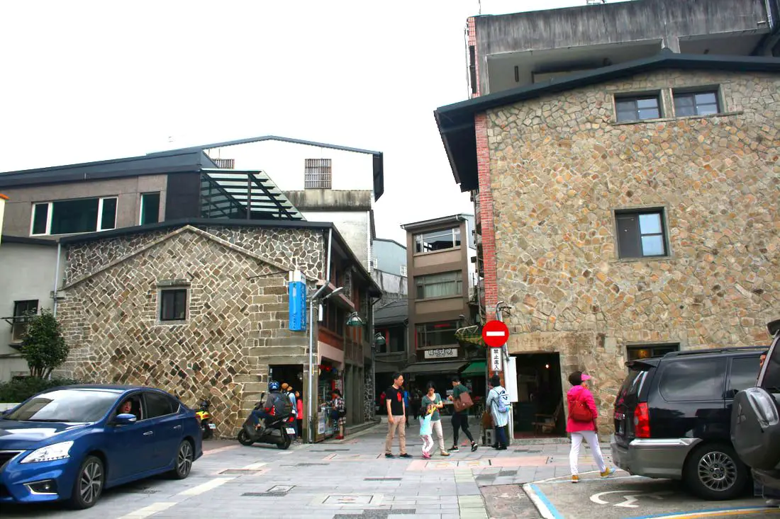
Pinglin Old Street (also known as Pinglin Shopping District 坪林商圈) is a small street in the mountainous Pinglin District in New Taipei. There are some great tea shops here, a tea museum, Qing dynasty stone houses, and beautiful views of the Beishi River and surrounding mountains. Also, there are some great hiking trails and camp sites nearby. If you love tea, Pinglin is the place for you.
Background: The first documented Han Chinese settlers came to Pinglin in 1821, mainly for agriculture. In the early days during the Qing Dynasty, the Han Chinese settlers here mainly grew tea and leeks. The only road through Pinglin at the time was the Danlan Old Trail (淡蘭古道). During the Qing Dynasty, Pinglin was an important stop along Danlan Old Trail (which means the road between Tamsui and Yilan), which was split into three paths, and Pinglin was on the Southern Path. The Southern Path winded from Mengjia Old Street to Liuzhangli, then to Shengkeng, and onto Shiding and then Pinglin which was a major tea producer at the time. Pinglin, the trail went over the mountains to Yilan. The Southern path was the quickest way to Yilan. During the Japanese Era until the 1980s, the populations remained small and the main economic output came from tea. Pinglin is the largest producer of Paozhong Tea (包種茶) in Taiwan. When National Freeway 5 was completed in 1990, originally there was no access to Pinglin. After much protest, a referendum was brought to the people, and 97% of voters agreed to allow access to National Freeway 5. Currently the Pinglin Shopping District covers Pinglin Old Street, Pinglin Middle School, Pinglin Agricultural Association, Tea Museum, and many other small tea shops in the area. It is a popular stop along National Freeway 5. Price: Free Hours: About 8 AM to 5 PM. Tours: You can also book a tour to Pinglin on KKday here or TripAdvisor here. Activities: Here you can river trace, SUP / Paddleboard, and more on KKday here. Hotels in Taipei: We have stayed at and recommend the Yuanshan Grand Hotel, once the tallest building in Taiwan and still the most grand (book on Booking.com here, Tripadvisor here, or Agoda here). We have stayed at and also recommend Fu Chang Hotel in Ximending, which is within walking distance of Ximending shopping district (book on Booking.com here, Tripadvisor here, or Agoda here). Looking for a hotel? We recommend booking through Booking.com here, which provides the best quality selection of accommodation in Taiwan. Find out where to stay in our Taiwan hotels guide or search for the best hotel deals in Taiwan here. How to get there: By Car: Go east on National Freeway 5, then get off at the Pinglin interchange. Continue east until you reach Pinglin Street. If you are looking for car rentals, you can also search Qeeq here, Klook here, or KKday here. You can also check out our car rental guide here. By Scooter: From Taipei, take highway 106 east from Shenkeng toward Shiding, pass through Shiding Bao Tunnel, and continue over the mountain past Huafan University, over to Pinglin. The street is at the center of town. Looking for scooter rental in Taipei? You can search on Klook here or KKday here to search for options. You can also check out our scooter rental guide here. By Bus: From Taipei City Call MRT station, you can take bus 912 to Bafenliao Station, the switch to bus 923 to Pinglin Station. The ride should take about 2 hours. You can also book tickets to travel to Pinglin via inter-city bus on Klook here. You can also book a Taipei Sightseeing: Hop On, Hop Off Open Top Bus on TripAdvisor here. By Bicycle: Cycling is the best way to enjoy Taiwan's landscapes if you have the time and energy. Looking for bicycle rentals in Taiwan? You can use Taiwan's many Youbike sharing stations, or search for rentals on KKday here, and search for tours on Klook here. You can also check out our Taiwan cycling guide here. You can also book a Sunset Riverside Bike Ride and Historical Tour, 4 Hour Cycling in Taipei, Ultimate 8-Hour Cycling City Tour, or Taipei City Bike Tour with Night Market Experience on TripAdvisor here. For more information, check out our Taiwan transportation guide here. Map: Please see below. 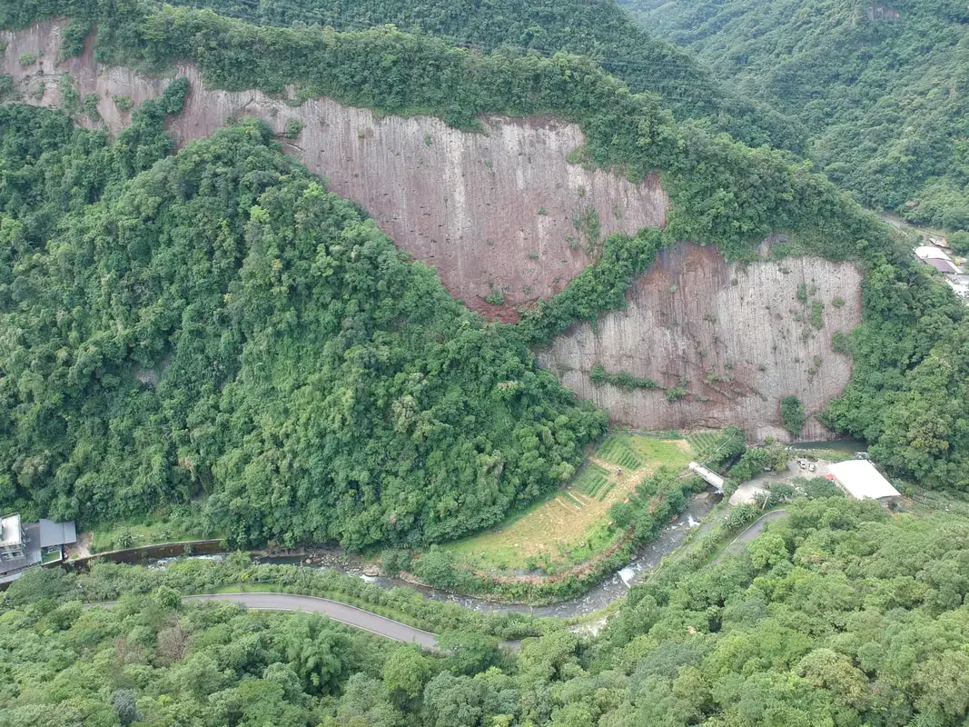
Throughout the mountains of Shiding and Pingxi are quite a few sheer cliffs and rock walls, formed from sedimentary rock being thrust upward by tectonic forces. Many of these places are not well known and hard to get to, but they are beautiful features in Taiwan's mountainous terrain. One of the largest of such rock walls is the Yuguiling Rock Wall in Shiding, which is the largest sandstone cliff in Northern Taiwan.
Background: The rock formations that form the mountains of Shiding and Pingxi formed as sediment under the ocean millions of years ago and were then uplifted thanks to the collision of the Eurasian and Philippine plates. The rocks are mainly sedimentary and are part of the same formation that forms the special rock formations on the northern coast around Keelung. The rock wall here is on private property and so can only be enjoyed from the road. Holes in the rock wall also appear to be home to many birds. The cliff here is 100 meters high at the middle and nearly 300 meters wide, making it the highest sandstone cliff in northern Taiwan. Price: Free Hours: 24/7 Tours: You can book a tour to Shiding Old Street on TripAdvisor here, Klook here or KKday here. Hotels in Taipei: We have stayed at and recommend the Yuanshan Grand Hotel, once the tallest building in Taiwan and still the most grand (book on Booking.com here, Tripadvisor here, or Agoda here). We have stayed at and also recommend Fu Chang Hotel in Ximending, which is within walking distance of Ximending shopping district (book on Booking.com here, Tripadvisor here, or Agoda here). Looking for a hotel? We recommend booking through Booking.com here, which provides the best quality selection of accommodation in Taiwan. Find out where to stay in our Taiwan hotels guide or search for the best hotel deals in Taiwan here. How to get there: By Car/Scooter: Take highway 106 east through Shiding until you reach the large U shaped bridge before Yongding Village. Do not get on the bridge, and take a right under the bridge up the mountain valley. Keep going straight until you reach the rock walls. If you are looking for car rentals, you can also search Qeeq here, Klook here, or KKday here. You can also check out our car rental guide here. Looking for scooter rental in Taipei? You can search on Klook here or KKday here to search for options. You can also check out our scooter rental guide here. By Bus: Take bus 795 from Shiding until you reach Tengliaokeng (藤寮坑) station. From there it is about 4 KM or one hour walk to get to the cliffs, not ideal! You can also book tickets to travel to Shiding via inter-city bus on Klook here. You can also book a Taipei Sightseeing: Hop On, Hop Off Open Top Bus on TripAdvisor here. By Bicycle: Cycling is the best way to enjoy Taiwan's landscapes if you have the time and energy. Looking for bicycle rentals in Taiwan? You can use Taiwan's many Youbike sharing stations, or search for rentals on KKday here, and search for tours on Klook here. You can also check out our Taiwan cycling guide here. You can also book a Sunset Riverside Bike Ride and Historical Tour, 4 Hour Cycling in Taipei, Ultimate 8-Hour Cycling City Tour, or Taipei City Bike Tour with Night Market Experience on TripAdvisor here. For more information, check out our Taiwan transportation guide here. Map: Pleas see below: 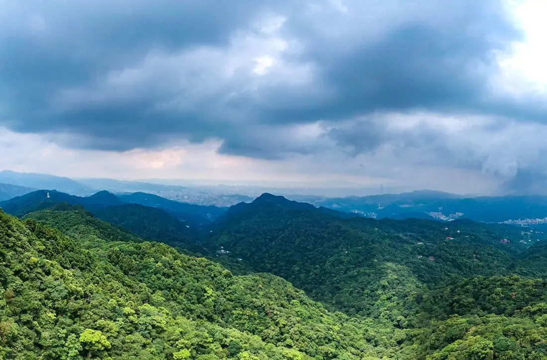
Ergeshan (aka Erge Mountain or Shijianshan) is a magnificent mountain hike in Shiding District of New Taipei. The trail features a short climb to a watch tower with 360 degrees of Xindian, Wenshan, and Shiding Districts. There are also great views of Taipei City and the surrounding area.
Background: The rock formations that form Ergeshan formed as sediment under the ocean millions of years ago, and was later uplifted thanks to the collision of the Eurasian and Phillipine plates. The rocks are mainly sedimentary and are part of the same formation that forms the special rock formations on the northern coast around Keelung, and the waterfalls in Pingxi. Ergeshan is the highest mountain in the surrounding area at 678 meters above sea level. It is one of the 100 lesser peaks in Taiwan. Hours: 24/7 Price: Free Length: 2.5 KM, 200 meters of elevation gain About 1.5 hours total Difficulty: Easy, The trail can be quite steep in some places, but overall an easy short hike. Tours: You can book a tour to Shiding on TripAdvisor here, Klook here or KKday here. Hotels in Taipei: We have stayed at and recommend the Yuanshan Grand Hotel, once the tallest building in Taiwan and still the most grand (book on Booking.com here, Tripadvisor here, or Agoda here). We have stayed at and also recommend Fu Chang Hotel in Ximending, which is within walking distance of Ximending shopping district (book on Booking.com here, Tripadvisor here, or Agoda here). Looking for a hotel? We recommend booking through Booking.com here, which provides the best quality selection of accommodation in Taiwan. Find out where to stay in our Taiwan hotels guide or search for the best hotel deals in Taiwan here. How to get there: By Bus: Take Bus GR12 from Xindian to Xiangdi Temple. The trailhead is about a 12 minute walk from there. You can also book tickets to travel to Shiding via inter-city bus on Klook here. You can also book a Taipei Sightseeing: Hop On, Hop Off Open Top Bus on TripAdvisor here. By Car/Scooter: Take provincial highway 9 to Xiandi Temple and take a turn up the mountain, and take a left at the monastery. The road ends at the trailhead. You can park further up the road for the faster way to get there. Looking for scooter rental in Taipei? You can search on Klook here or KKday here to search for options. You can also check out our scooter rental guide here. If you are looking for car rentals, you can also search Qeeq here, Klook here, or KKday here. You can also check out our car rental guide here. By Bicycle: Cycling is the best way to enjoy Taiwan's landscapes if you have the time and energy. Looking for bicycle rentals in Taiwan? You can use Taiwan's many Youbike sharing stations, or search for rentals on KKday here, and search for tours on Klook here. You can also check out our Taiwan cycling guide here. You can also book a Sunset Riverside Bike Ride and Historical Tour, 4 Hour Cycling in Taipei, Ultimate 8-Hour Cycling City Tour, or Taipei City Bike Tour with Night Market Experience on TripAdvisor here. For more information, check out our Taiwan transportation guide here. Map: Please see below: 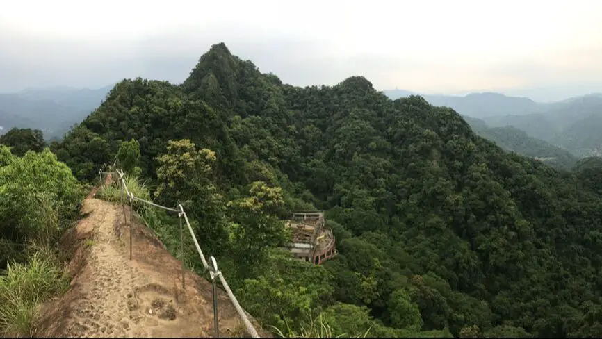
The Huangdidian Trail (aka Huangdi Temple Trail) is a magnificent mountain hike in Shiding District of New Taipei. The trail features ladder climbs, rope climbs, and rock climbs with the aid of ropes, and the top has a vertical drop on either side. There are also great views of Taipei and the surrounding area.
Background: The rock formations that form the Huangdidian hike formed as sediment under the ocean millions of years ago, and was later uplifted thanks to the collision of the Eurasian and Phillipine plates. The rocks are mainly sedimentary and are part of the same formation that forms the special rock formations on the northern coast around Keelung, and the waterfalls in Pingxi. Huangdidian gets its name from the Tianwang Temple below (天王廟) which is also known as the Huangdi Temple (皇帝殿). The Huangdidian trail climbs up Huangdidian Mountain, which has three peaks, the highest of which is 593 meters above sea level. Recently rope railings were installed at the top of the mountain to improve safety. Even so, the hike is still really scary. Hours: 24/7 Price: Free Length: 4.5 KM, 300 meters of elevation gain About three hours total Difficulty: Moderate, there are some rope climbs and ladder climbs up sheer rock face, and sheer drop-off on either side with little protection from falls in some places. Also the trail can be quite steep in some places. Tours: You can book a tour to Shiding on TripAdvisor here, Klook here or KKday here. Hotels in Taipei: We have stayed at and recommend the Yuanshan Grand Hotel, once the tallest building in Taiwan and still the most grand (book on Booking.com here, Tripadvisor here, or Agoda here). We have stayed at and also recommend Fu Chang Hotel in Ximending, which is within walking distance of Ximending shopping district (book on Booking.com here, Tripadvisor here, or Agoda here). Looking for a hotel? We recommend booking through Booking.com here, which provides the best quality selection of accommodation in Taiwan. Find out where to stay in our Taiwan hotels guide or search for the best hotel deals in Taiwan here. How to get there: By Bus: Take Bus 912 from Taipei City Hall, then switch buses at Wanfu Bridge. Take Bus 666 to Huangdi Temple station, and the trail head is about a 15 minute walk up the hill. You can also book tickets to travel to Shiding via inter-city bus on Klook here. You can also book a Taipei Sightseeing: Hop On, Hop Off Open Top Bus on TripAdvisor here. By Car/Scooter: Take highway 106 past Shiding Old Street, then turn left on a small road Marked "Huangdidian." There is a temple with a bunch of yellow lanterns in front of it. Looking for scooter rental in Taipei? You can search on Klook here or KKday here to search for options. You can also check out our scooter rental guide here. If you are looking for car rentals, you can also search Qeeq here, Klook here, or KKday here. You can also check out our car rental guide here. By Bicycle: Cycling is the best way to enjoy Taiwan's landscapes if you have the time and energy. Looking for bicycle rentals in Taiwan? You can use Taiwan's many Youbike sharing stations, or search for rentals on KKday here, and search for tours on Klook here. You can also check out our Taiwan cycling guide here. You can also book a Sunset Riverside Bike Ride and Historical Tour, 4 Hour Cycling in Taipei, Ultimate 8-Hour Cycling City Tour, or Taipei City Bike Tour with Night Market Experience on TripAdvisor here. For more information, check out our Taiwan transportation guide here. Map: Please see below: 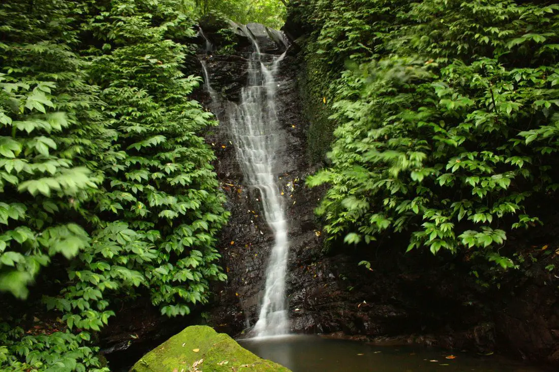
Dajianshan Waterfall (aka Dajianshan Falls) is a set of waterfalls in Xizhi District of New Taipei City, Taiwan. It a somewhat difficult and steep hiking path that takes about an hour to walk up, and includes a six main tiers of waterfall and amazing natural scenery. It's spectacular cascading falls and pools have made it a most popular destination in the area.
Background: Dajianshan Waterfall is roughly 200 meters high (650 feet) from the lowest falls to the highest falls, and is broken up by six sections of waterfalls. The rock formations that form the Waterfalls formed as sediment under the ocean millions of years ago and were then uplifted thanks to the collision of the Eurasian and Philippine plates. The rocks are mainly sedimentary and are part of the same formation that forms the special rock formations on the northern coast around Keelung. The rocks here easily erode, making for odd shapes in the riverbed. Due to the difficult nature of the trail, it is usually free of people, even on weekends. Hours: 24/7 Price: Free When to go: Go in the spring time when there is more rain. If you go during the dry season, the waterfall will be quite small. Difficulty: Moderate, 200 meter elevation gain. Takes about an hour to complete. Tours and Activities: You can book a river tracing experience at Dajianshan Waterfall on KKday here. Hotels in Taipei: High end: We have stayed at and recommend the Yuanshan Grand Hotel, once the tallest building in Taiwan and still the most grand (book on Booking.com here, Tripadvisor here, or Agoda here). We also recommend Fullon Hotel which has locations in Tamsui and Fulong near the beach (book on Booking.com here, Tripadvisor here, Agoda here, or Hotels.com here). Looking for a hotel? We recommend booking through Booking.com here, which provides the best quality selection of accommodation in Taiwan. Find out where to stay in our Taiwan hotels guide or search for the best hotel deals in Taiwan here. How to get there: By Bus: From Xizhi TRA station, take bus F911 to Fuji Mountain Villa stop, then walk through the neighborhood, which will take you to a mountain road on the back side. The waterfall is about a 15 minute walk from Fuji Mountain Villa. You can purchase a discount easy card to use on the MRT from Klook here or KKday here. You can also book an MRT travel pass on Klook here. By Car/Scooter: From provincial highway 5 in Xizhi, turn up the mountain after reaching the Xizhi Administrative Building (汐止行政中心). Then go up the mountain and turn into Xiufeng Road, aka Fuji Mountain Villa. After that, drive through the neighborhood, which will take you to a mountain road on the back side. The waterfall is about a 3 minute ride from Fuji Mountain Villa, on the switchback just before Qiedong Waterfall. Looking for scooter rental in Taipei? You can search on Klook here or KKday here to search for options. You can also check out our scooter rental guide here. If you are looking for car rentals, you can also search Qeeq here, Klook here, or KKday here. You can also check out our car rental guide here. By Bicycle: Cycling is the best way to enjoy Taiwan's landscapes if you have the time and energy. Looking for bicycle rentals in Taiwan? You can use Taiwan's many Youbike sharing stations, or search for rentals on KKday here, and search for tours on Klook here. You can also check out our Taiwan cycling guide here. You can also book a Sunset Riverside Bike Ride and Historical Tour, 4 Hour Cycling in Taipei, Ultimate 8-Hour Cycling City Tour, or Taipei City Bike Tour with Night Market Experience on TripAdvisor here. For more information, check out our Taiwan transportation guide here. Map: Please see below 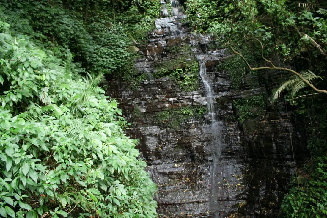
Xiufeng Waterfall is a tall waterfall in Xizhi District in New Taipei, Taiwan. It is easily accessible via a flat hiking path that takes about 10 minutes to complete, and includes amazing views of Taipei along the way. It's spectacular cascading falls are definitely worth a stop for anyone in Taiwan.
Background: Xiufeng Waterfall is roughly 10 meters high and 2 meters wide (32 x 13 ft.). It is located on Dajianshan in Xizhi, and connects with other Dajianshan trails in the area. The rocks here easily erode, making for odd shapes in the riverbed. Hours: 24/7 Price: Free When to go: Go in the spring time when there is more rain. If you go during the dry season, the waterfall will be quite small. Difficulty: Easy Tours: You can book a river tracing experience near Xiufeng Waterfall on KKday here. Hotels in Taipei: High end: We have stayed at and recommend the Yuanshan Grand Hotel, once the tallest building in Taiwan and still the most grand (book on Booking.com here, Tripadvisor here, or Agoda here). We also recommend Fullon Hotel which has locations in Tamsui and Fulong near the beach (book on Booking.com here, Tripadvisor here, Agoda here, or Hotels.com here). Looking for a hotel? We recommend booking through Booking.com here, which provides the best quality selection of accommodation in Taiwan. Find out where to stay in our Taiwan hotels guide or search for the best hotel deals in Taiwan here. How to get there: By Train: Take the TRA to Xizhi Station, then take a bus up the mountain to Xiufeng Watefall stop. You can purchase a discount easy card to use on the MRT from Klook here or KKday here. You can also book an MRT travel pass on Klook here. By Car/Scooter: From central Taipei, take Provincial Highway 5 east toward Xizhi, turn up the mountain once you reach the Xizhi District Administrative building. The trailhead is on the right side of the road on a bend. Scooter parking is free at the entrance. Looking for scooter rental in Taipei? You can search on Klook here or KKday here to search for options. You can also check out our scooter rental guide here. If you are looking for car rentals, you can also search Qeeq here, Klook here, or KKday here. You can also check out our car rental guide here. By Bicycle: Cycling is the best way to enjoy Taiwan's landscapes if you have the time and energy. Looking for bicycle rentals in Taiwan? You can use Taiwan's many Youbike sharing stations, or search for rentals on KKday here, and search for tours on Klook here. You can also check out our Taiwan cycling guide here. You can also book a Sunset Riverside Bike Ride and Historical Tour, 4 Hour Cycling in Taipei, Ultimate 8-Hour Cycling City Tour, or Taipei City Bike Tour with Night Market Experience on TripAdvisor here. For more information, check out our Taiwan transportation guide here. Map: Please see below 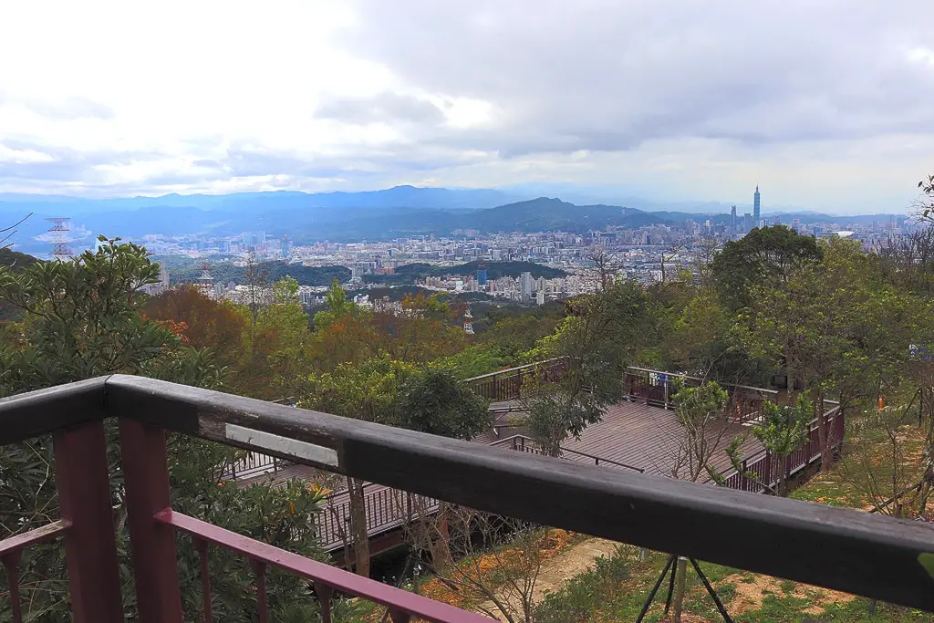
Bishan Campground (aka Bishan Camping Area) in Neihu District of Taipei City is the only free campground run by Taipei City (although it has an extension campground in Beitou). Near the campground is Bishan Temple, which has one of the best views of Taipei. Besides camping and temple worship, the area is also a popular hiking spot, and there are multiple tourist farms and tea shops to explore.
How to apply for a camping spot: You can apply using this online form (it's in English!): http://gisweb.taipei.gov.tw/TPCamp/en/ABishan.aspx You must apply at least 7 days in advance, but no more than 30 days in advance. You must enter your passport ID or Taiwan ID. You can check the status of the application online as well. For more info, check here (Chinese): https://www.geo.gov.taipei/mp10504b/ Price: Free! Utilities:
Hours: Camping time starts at 2 PM and ends at 1 PM the next day. You can only stay for two nights at a time. Tours and Activities: You can book a ticket to the Neihu Strawberry Garden on KKday here. You can look for more activities on Klook here or KKday here. How to get there: By Bus: You can take a bus to about 1 KM away from the campsite, but then you have to walk with all of that gear. If that's not what you want then you should take a taxi or your own vehicle. You can also book a Taipei Sightseeing: Hop On, Hop Off Open Top Bus on TripAdvisor here. By Scooter/Car: From East Neihu, drive up Bishan Raod (碧山路) until you see the campground. It's hard to miss. Looking for scooter rental in Taipei? You can search on Klook here or KKday here to search for options. You can also check out our scooter rental guide here. If you are looking for car rentals, you can also search Qeeq here, Klook here, or KKday here. You can also check out our car rental guide here. By Bicycle: Cycling is the best way to enjoy Taiwan's landscapes if you have the time and energy. Looking for bicycle rentals in Taiwan? You can use Taiwan's many Youbike sharing stations, or search for rentals on KKday here, and search for tours on Klook here. You can also check out our Taiwan cycling guide here. You can also book a Sunset Riverside Bike Ride and Historical Tour, 4 Hour Cycling in Taipei, Ultimate 8-Hour Cycling City Tour, or Taipei City Bike Tour with Night Market Experience on TripAdvisor here. For more information, check out our Taiwan transportation guide here. Map: Please see below: 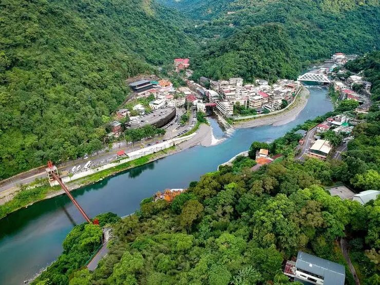
Wulai has become a major tourist attraction, partly because of its close proximity to Taipei. It has museums, waterfalls, a gondola, a train, an old street night market, and most of all hot springs. It has an old Japanese era coal mining railroad track which has been restored with a working train. In addition there are hikes, wildlife, and endless mountain scenery to explore.
Background: Wulai was originally an Atayal aborigine village, its name meaning hot and poisonous. There has always been natural hot springs in Wulai, but much of that water has been channeled into hotels and public bathhouses. The free hot springs stood at the bottom of the hill next to the river, and was a collection of used hot spring water from the hotels and paid hot springs above. In its prime, it boasted the largest free outdoor hot springs in Taiwan. Recently the District of Wulai in New Taipei has become a major tourist attraction, partly because of its close proximity to Taipei. It has museums, waterfalls, a gondola, a train, an old street night market, and most of all hot springs. The main delicacies on the old street are Taiwan ingenuous foods such as wild boar meat and rice steamed in bamboo. Hours: Wulai Old Street: Roughly 10 AM to 8 PM Cable Car and Yun Hsien Amusement Park Entrance: 9 AM to 4:30 PM You can book tickets to the gondola and to Yun Hsien theme park on Klook here or KKday here. Neidong Waterfall: 8 AM to 5 PM. You can book tickets to Neidong Forest Recreation Area on KKday here or Klook here. Price: Wulai Old Street: Free Cable Car and Yun Hsien Amusement Park Entrance: 220 NT per person You can book tickets to the gondola and to Yun Hsien theme park on Klook here or KKday here. Neidong Waterfall: 65 NT per person. You can book tickets on KKday here or Klook here. Hot Spring Bath: 300-500 NT. You can look for hot spring bath experiences on Klook here or KKday here. Delicacies: Wilde Boar meat, hot spring eggs, rice steamed in bamboo, among others. Hotels in Wulai: There are many hot spring hotels in Wulai that have a hot spring tub right in the room. We have stayed at and recommend Wulai SungLyu Hot Spring Resort, which is a hot spring resort with great views just above Wulai Old Street. You can book on Booking.com here, Agoda here, Hotels.com here, TripAdvisor here, Trip.com here, Klook here, Kayak here, or Expedia here. Looking for a hotel? We recommend booking through Booking.com here, which provides the best quality selection of accommodation in Taiwan. Find out where to stay in our Taiwan hotels guide or search for the best hotel deals in Taiwan here. How to get there: By Bus: From central Taipei, take bus 849 to Wulai Old Street. The trips takes about an hour and a half. You can purchase a discount easy card to use on a bus to Wulai on Klook here or KKday here. You can also book a Taipei travel pass on Klook here. By Car/Scooter: From Taipei, take provincial highway 9甲 to Wulai. There is a large paid parking garage in front of the old street. You may also be able to find free parking up the mountain. If you are looking for car rentals, you can also search Qeeq here, Klook here, or KKday here. You can also check out our car rental guide here. Looking for scooter rental in Taipei? You can search on Klook here or KKday here to search for options. You can also check out our scooter rental guide here. By Taxi: You can take short rides for about 150 NT, or hire a Taxi for a day for around 150 USD on Klook here. By Bicycle: Cycling is the best way to enjoy Taiwan's landscapes if you have the time and energy. Looking for bicycle rentals in Taiwan? You can use Taiwan's many Youbike sharing stations, or search for rentals on KKday here, and search for tours on Klook here. You can also check out our Taiwan cycling guide here. You can also book a Sunset Riverside Bike Ride and Historical Tour, 4 Hour Cycling in Taipei, Ultimate 8-Hour Cycling City Tour, or Taipei City Bike Tour with Night Market Experience on TripAdvisor here. For more information, check out our Taiwan transportation guide here. Map: Please see below of the places covered in this blog: 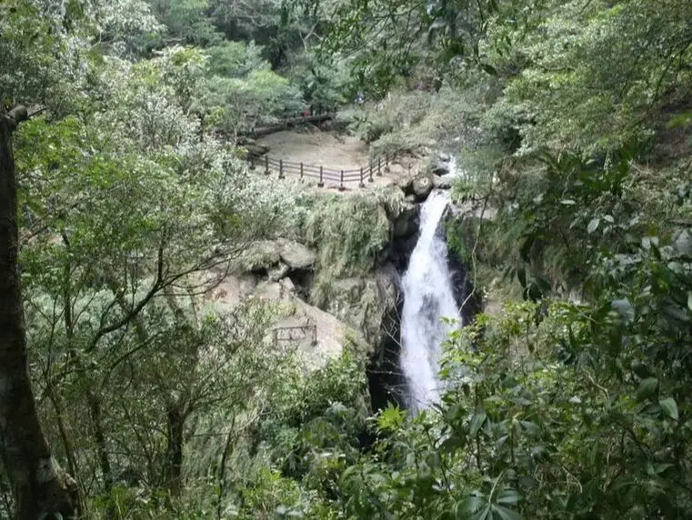
Full Moon Waterfall (Manyue Waterfall) lies in Sanxia's Manyueyuan National Forest Recreation Area in New Taipei. It's a beautiful waterfall and an easy family hike.
滿月圓瀑布位於新北市三峽區的滿月圓國家森林游樂區,是一個美麗的瀑布且容易的步道。 When to go: I actually recommend not going until the new tourist information center and Virgin Waterfall are opened up. That's right, Virgin Waterfall, the biggest waterfall in the park, is not even accessible, but you can still see Manyueyuan Waterfall for a discounted price. 其實我建議等到處女瀑布開放之後再去。對了,處女瀑布關閉了,整個公園最大的瀑布。但是滿月圓瀑布有優惠哦! Price: 80 NT You can book a ticket to Manyueyuan National Forest Recreation Area on KKday here. Hotels in Taipei: We have stayed at and recommend the Yuanshan Grand Hotel, once the tallest building in Taiwan and still the most grand (book on Booking.com here, Tripadvisor here, or Agoda here). We have stayed at and also recommend Fu Chang Hotel in Ximending, which is within walking distance of Ximending shopping district (book on Booking.com here, Tripadvisor here, or Agoda here). Looking for a hotel? We recommend booking through Booking.com here, which provides the best quality selection of accommodation in Taiwan. Find out where to stay in our Taiwan hotels guide or search for the best hotel deals in Taiwan here. How to get there: To get there, the only way is by taking your own vehicle or taxi. According to the recreation area website, there are no buses to get there. 去那邊只能開車或搭計程車。本地區的網站說沒有公車。 Looking for scooter rental in Taipei? You can search on Klook here or KKday here to search for options. You can also check out our scooter rental guide here. If you are looking for car rentals, you can also search Qeeq here, Klook here, or KKday here. You can also check out our car rental guide here. Map: See a map of the waterfall below: 請參考以下的地圖: 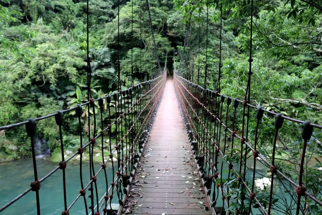
Kuolai Old Trail was a major intersection along the Danlan Old Trail that connects Keelung to Yilan through the mountains of New Taipei. There are three pedestrian bridges, multiple camping locations, lots of swimming spots, and beautiful views of the surrounding mountains. Also, there are some great hiking trails along multiple sections of the original Danlan Old Trail to discover.
Background: Kuolai was originally a small village create in the late Qing Dynasty. In the early days during the Qing Dynasty, the Han Chinese settlers here mainly grew tea and leeks. During the Qing Dynasty, Kuolai was an important stop along the Danlan Old Trail (淡蘭古道 which means the road between Tamsui and Yilan), which was split into three paths, and Kuolai was on the middle path. The middle path winded from Nuannuan to Shifen, then to Kuolai, and then finally over the mountains to Wai'ao in Yilan. Part of section connecting Kuolai to Wai'ao through Wantan is known as the Wantan Old Trail. Kuolai also intersects with the Beishi River Old Trail which connects Shuangxi to Pinglin. During the Japanese Era until the 1980s, the major industry in the area besides tea growing was coal mining, The coal mining industry winded down in the 1980s and 90s in Taiwan. Currently Kuolai is a popular stop near National Highway 5 in northern Pinglin. Besides the history, there is also some great hiking trails and scenery nearby. Price: Free Hours: About 8 AM to 5 PM. Tours and Activities: Here you can river trace, SUP / Paddleboard, and more on KKday here. Hotels in Taipei: We have stayed at and recommend the Yuanshan Grand Hotel, once the tallest building in Taiwan and still the most grand (book on Booking.com here, Tripadvisor here, or Agoda here). We have stayed at and also recommend Fu Chang Hotel in Ximending, which is within walking distance of Ximending shopping district (book on Booking.com here, Tripadvisor here, or Agoda here). Looking for a hotel? We recommend booking through Booking.com here, which provides the best quality selection of accommodation in Taiwan. Find out where to stay in our Taiwan hotels guide or search for the best hotel deals in Taiwan here. How to get there: By Car: Go east on National Freeway 5, then get off at the Pinglin interchange. Continue north east on Pingshuang Road, which follows the Beishi River Old Trail. You can find the many suspension bridges on the side of the road. If you are looking for car rentals, you can also search Qeeq here, Klook here, or KKday here. You can also check out our car rental guide here. By Scooter: From Taipei, take highway 106 east from Shenkeng toward Shiding, pass over the mountain to Pinglin, then once in Pinglin continue north east on Pingshuang Road, which follows the Beishi River Old Trail. You can find the many suspension bridges on the side of the road. Looking for scooter rental in Taipei? You can search on Klook here or KKday here to search for options. You can also check out our scooter rental guide here. By Bus: From Taipei City Call MRT station, you can take bus 912 to Bafenliao Station, the switch to bus 923 to Pinglin Station. The ride should take about 2 hours. From Pinglin, you can take the F721 bus up along the Beishi River Old Trail. This will take up a lot of time. You can also book tickets to travel to Pinglin via inter-city bus on Klook here. You can also book a Taipei Sightseeing: Hop On, Hop Off Open Top Bus on TripAdvisor here. By Bicycle: Cycling is the best way to enjoy Taiwan's landscapes if you have the time and energy. Looking for bicycle rentals in Taiwan? You can use Taiwan's many Youbike sharing stations, or search for rentals on KKday here, and search for tours on Klook here. You can also check out our Taiwan cycling guide here. You can also book a Sunset Riverside Bike Ride and Historical Tour, 4 Hour Cycling in Taipei, Ultimate 8-Hour Cycling City Tour, or Taipei City Bike Tour with Night Market Experience on TripAdvisor here. For more information, check out our Taiwan transportation guide here. Map: Please see below. 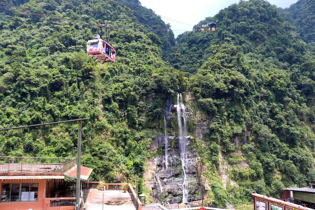
Wulai Waterfall is the highest waterfall in northern Taiwan. Here you can find a street with snacks and restaurants, and a gondola that leads to a second tier of the waterfall and an amusement park. In addition there are hikes, wildlife, and endless mountain scenery to explore.
Background: Wulai was originally an Atayal aborigine village, its name meaning hot and poisonous. There has always been natural hot springs in Wulai, but much of that water has been channeled into hotels and public bathhouses. The free hot springs stood at the bottom of the hill next to the river, and was a collection of used hot spring water from the hotels and paid hot springs above. In its prime, it boasted the largest free outdoor hot springs in Taiwan. Recently the District of Wulai in New Taipei has become a major tourist attraction, partly because of its close proximity to Taipei. It has museums, waterfalls, a gondola, a train, an old street night market, and most of all hot springs. The main delicacies on the old street are Taiwan ingenuous foods such as wild boar meat and rice steamed in bamboo. Wulai waterfall is 80 meters high, making it the highest waterfall in northern Taiwan. It's highest point sits at 230 meters above sea level, and drops to 150 meters above sea level. The waterfall is also about 10 meters wide. Yunceng Amusement Park began construction in 1960 and was completed in 1970. It includes a gondola, hotel, swimming pool, canoe pond, and other activities. Originally it had a roller coaster, pirate ship, and other rides, but these have all been taken down. Hours: Waterfall: 24/7 Cable Car and Yun Hsien Amusement Park Entrance: 9 AM to 4:30 PM You can book tickets to the gondola and to Yun Hsien theme park on Klook here or KKday here. Neidong Waterfall: 8 AM to 5 PM. You can book tickets to Neidong Forest Recreation Area on KKday here or Klook here. Price: Wulai Waterfall: Free Cable Car and Yun Hsien Amusement Park Entrance: 220 NT per person You can book tickets to the gondola and to Yun Hsien theme park on Klook here or KKday here. Neidong Waterfall: 65 NT per person. You can book tickets on KKday here or Klook here. Hot Spring Bath: 300-500 NT. You can look for hot spring bath experiences on Klook here or KKday here. Tours and Activities: You can book a Taiwan Wulai Aboriginal Tribe afternoon Tour on TripAdvisor here. You can also book a tour of Wulai on KKday here. You can also book a ticket on the Wulai Train on Klook here, or a river tracing experience in Wulai on Klook here, or SUP paddleboarding experience in Wulai on KKday here, hot spring baths on Klook here or KKday here, on or tickets to the gondola and to Yun Hsien theme park on Klook here or KKday here. Hotels in Wulai: There are many hot spring hotels in Wulai that have a hot spring tub right in the room. We have stayed at and recommend Wulai SungLyu Hot Spring Resort, which is a hot spring resort with great views just above Wulai Old Street. You can book on Booking.com here, Agoda here, Hotels.com here, TripAdvisor here, Trip.com here, Klook here, Kayak here, or Expedia here. Looking for a hotel? We recommend booking through Booking.com here, which provides the best quality selection of accommodation in Taiwan. Find out where to stay in our Taiwan hotels guide or search for the best hotel deals in Taiwan here. How to get there: By Bus: From central Taipei, take bus 849 to Wulai Waterfall. The trips takes about an hour and a half. You can purchase a discount easy card to use on a bus to Wulai on Klook here or KKday here. You can also book a Taipei travel pass on Klook here. By Car: From Taipei, take provincial highway 9甲 to Wulai. There is a large paid parking garage in front of the old street. You may also be able to find free parking further up the road closer to the waterfall but car parking is very limited. If you are looking for car rentals, you can also search Qeeq here, Klook here, or KKday here. You can also check out our car rental guide here. Looking for scooter rental in Taipei? You can search on Klook here or KKday here to search for options. You can also check out our scooter rental guide here. By Taxi: You can take short rides for about 150 NT, or hire a Taxi for a day for around 150 USD on Klook here. By Bicycle: Cycling is the best way to enjoy Taiwan's landscapes if you have the time and energy. Looking for bicycle rentals in Taiwan? You can use Taiwan's many Youbike sharing stations, or search for rentals on KKday here, and search for tours on Klook here. You can also check out our Taiwan cycling guide here. You can also book a Sunset Riverside Bike Ride and Historical Tour, 4 Hour Cycling in Taipei, Ultimate 8-Hour Cycling City Tour, or Taipei City Bike Tour with Night Market Experience on TripAdvisor here. For more information, check out our Taiwan transportation guide here. Map: Please see below of the places covered in this blog: 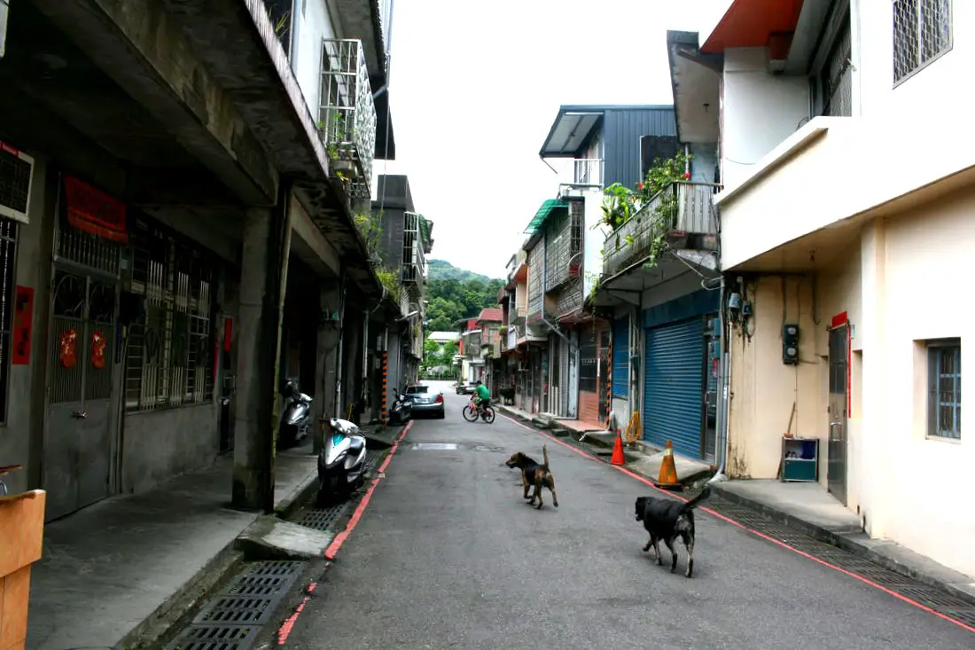
Mudan Old Street is a small old street in Mudan Neighborhood of Shuangxi District. The old street is almost totally a residential area. Now it is a quiet town with very little tourists, but with lots of nature sights, mountain roads, camp sites, and hiking trails nearby.
Background: Mudan is named after the tree peonie flower. During the Qing Dynasty, Mudan was an important stop along the Danlan Old Trail (淡蘭古道 which means the road between Tamsui and Yilan), which was split into three paths, and Mudan was on the Northern Path. The Northern Path winded from Mengjia Old Street to Nuannuan, then to Ruifang, and onto Jiufen and Houtong. From Houtong, the road then went to Mudan and then Shuangxi, then went along the coast to Yilan. During this time, most of the things traded were tea leaves and agricultural goods. Historically Mudan and the areas nearby have been rural, and in the 1900s relied on coal, gold, and mercury mining to drive the economy. The mining industry died down in the late 1900s and is now defunct. Currently the neighborhood of Mudan has a population of only 1953 people, and is dropping every year. The Mudan Train Station was recently upgraded to a simple station, with a TRA employee stationed there to sell tickets. There are about 200 people coming and leaving the station every day. Only the shuttle train stops at the station. Now it is a quiet town with very little tourists, but with lots of nature sights, mountain roads, and hiking trails nearby. Hours: About 10 AM to 6 PM. Price: Free Tours and Activities Around Mudan: Don't forget that there are many activities available around Ruifang such as Rock Climbing, Hiking, kayaking, canoeing, snorkeling, SUP / paddle boarding, water biking, Diving, River Tracing / Canyoneering, ATVing, Horse Riding, Cooking Class, photo shoot, Jingtong Sky Lantern Police Station, Shifen Sky Lantern Experience, Waterfall Zipline, Waterfall Diving, and more on Tripadvisor here, Klook here, or KKday here. Hotels in Taipei: We have stayed at and recommend the Yuanshan Grand Hotel, once the tallest building in Taiwan and still the most grand (book on Booking.com here, Tripadvisor here, or Agoda here). We have stayed at and also recommend Fu Chang Hotel in Ximending, which is within walking distance of Ximending shopping district (book on Booking.com here, Tripadvisor here, or Agoda here). Looking for a hotel? We recommend booking through Booking.com here, which provides the best quality selection of accommodation in Taiwan. Find out where to stay in our Taiwan hotels guide or search for the best hotel deals in Taiwan here. How to get there: By Train: Take the TRA to Mudan Station. Only the shuttle train stops at the station. Book tickets via the normal train (TRA) on Klook here. By Car/Scooter: From Taipei, on provincial highway 5 until you reach Keelung, then take provincial highway 2B to Shuangxi. You then need to take county raod 102 to Mudan. The old street is only one lane, so you can get stuck if driving a car. Looking for scooter rental in Taipei? You can search on Klook here or KKday here to search for options. You can also check out our scooter rental guide here. If you are looking for car rentals, you can also search Qeeq here, Klook here, or KKday here. You can also check out our car rental guide here. By Bicycle: Cycling is the best way to enjoy Taiwan's landscapes if you have the time and energy. Looking for bicycle rentals in Taiwan? You can use Taiwan's many Youbike sharing stations, or search for rentals on KKday here, and search for tours on Klook here. You can also check out our Taiwan cycling guide here. You can also book a Sunset Riverside Bike Ride and Historical Tour, 4 Hour Cycling in Taipei, Ultimate 8-Hour Cycling City Tour, or Taipei City Bike Tour with Night Market Experience on TripAdvisor here. For more information, check out our Taiwan transportation guide here. Map: Please see below: 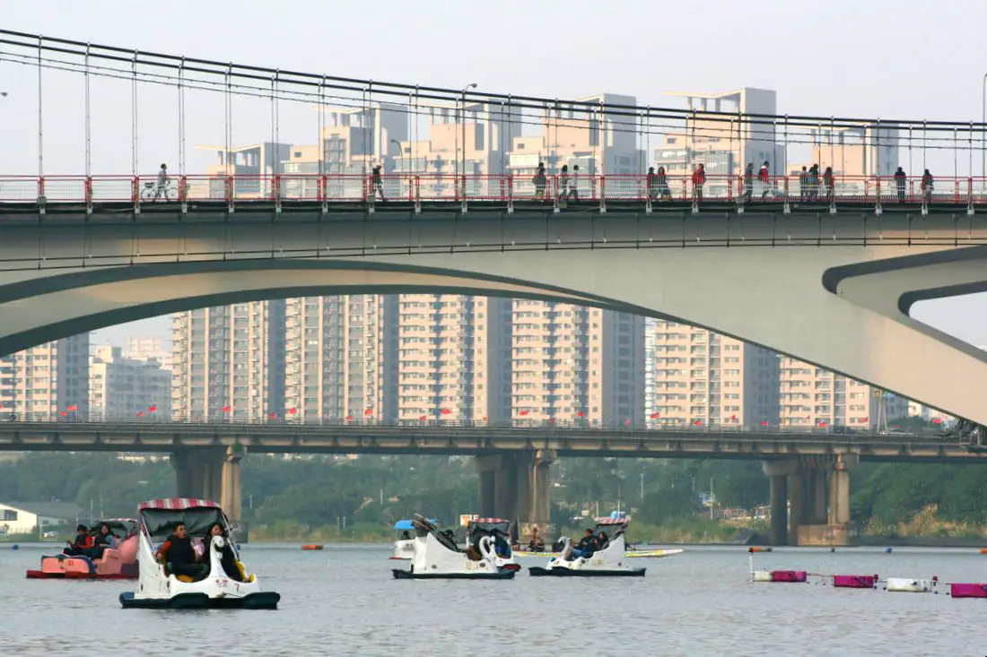
Bitan is a slow moving part of the Xindian River in Xindian District of New Taipei. It is also known as Bitan Lake, or Bitan Scenic Area (碧潭風景區). Here you can bike ride, paddle boat, go hiking, and shop at Xindian Old Street (新店老街). With convenient transportation via Taipei MRT, it is definitely worth a stop on your trip to Taipei.
Background: The name Bitan means "green lake" in Chinese, which was coined by Sun Ke, vice chairman of the KMT after WWII. It is also known as Chibi Lake (赤壁潭)、Shibi Lake (石壁潭)、and Shishan Big Lake (獅山邊大潭). Bitan suspension bridge was completed in 1937. Before that time, ferry boat was the best means of transport. In 1997, the National Freeway 3 bridge was completed across the lake. In 2000, Bitan Suspension Bridge was refurbished. It is also known as one of Taiwan's top 12 or top 8 sights. It is also a very popular recreational spot for Taipie residents on the weekend. Near Bitan is Xindian Old Street (新店老街), which sells street food, fruits, and vegetables. It has been the main acrigultural market in Xindian for over a hundred years. The Changxing Temple on the Old Street (長興宮) is over 150 years old, and is dedicated to the Earth God. Hours: About 8 AM to 10 PM. Price: Free entrance Ferry boat: 20 NT one way Paddle boats: 300 NT for a two person boat, more for more people or electric boats Bike rental: 15-70 NT per hour depending on the bike SUP Paddle Boarding: 2000-3000 NT You can book an SUP / Stand up Paddle boarding experience at Bitan on TripAdvisor here, Klook here, or KKday here. Tours and Activities: You can book an SUP / Stand up Paddle boarding experience at Bitan on TripAdvisor here, Klook here, or KKday here. How to get there: By MRT: Take the Green Line MRT south to Xindian Station, or Xiaobitan Station. Xindian Old Street is within walking distance of Xindian Old Street. From Xiaobitan Station, you can rent a bike and ride up the river to Xindian Old Street. You can also book an MRT travel pass on Klook here. By car/scooter: From Taipei, go south on provincial highway 9 until you reach Xindian Old Street. There is paid parking near the old street. Looking for scooter rental in Taipei? You can search on Klook here or KKday here to search for options. You can also check out our scooter rental guide here. If you are looking for car rentals, you can also search Qeeq here, Klook here, or KKday here. You can also check out our car rental guide here. By Bicycle: Cycling is the best way to enjoy Taiwan's landscapes if you have the time and energy. Looking for bicycle rentals in Taiwan? You can use Taiwan's many Youbike sharing stations, or search for rentals on KKday here, and search for tours on Klook here. You can also check out our Taiwan cycling guide here. You can also book a Sunset Riverside Bike Ride and Historical Tour, 4 Hour Cycling in Taipei, Ultimate 8-Hour Cycling City Tour, or Taipei City Bike Tour with Night Market Experience on TripAdvisor here. For more information, check out our Taiwan transportation guide here. Map: Please see below: 
Yuanshan in Sanxia District is a popular hike in greater Taipei. It features a short easy hike has some amazing views of southern Taipei. It can also get very crowded on weekends despite the lack of public transportation. If you are looking for amazing views that are easy to get to, this is the place.
Background: Yuanshan stands at 299 meters above sea level, and the top features a bell tower and exposed rocks that provide a great view of Taipei. From the top you can enjoy views of Taipei such as Sanxia and Shulin Districts of New Taipei, as well as north east Taoyuan. Currently the hike is very popular for local people especially on the weekends. When to go: Go on a sunny day when the air is clear for the best views. Also consider going early in the morning or on a weekday, because the trails can get really clogged with crowds of people during the day on weekends. Tours and Activities Around Sanxia: Don't forget that there are many activities available around Sanxia such as Rock Climbing, Hiking, kayaking, canoeing, snorkeling, SUP / paddle boarding, water biking, Diving, River Tracing / Canyoneering, ATVing, Horse Riding, Cooking Class, photo shoot, Jingtong Sky Lantern Police Station, Shifen Sky Lantern Experience, Waterfall Zipline, Waterfall Diving, and more on Tripadvisor here, Klook here, or KKday here. Hotels in Taipei: We have stayed at and recommend the Yuanshan Grand Hotel, once the tallest building in Taiwan and still the most grand (book on Booking.com here, Tripadvisor here, or Agoda here). We have stayed at and also recommend Fu Chang Hotel in Ximending, which is within walking distance of Ximending shopping district (book on Booking.com here, Tripadvisor here, or Agoda here). Looking for a hotel? We recommend booking through Booking.com here, which provides the best quality selection of accommodation in Taiwan. Find out where to stay in our Taiwan hotels guide or search for the best hotel deals in Taiwan here. How to get there: By Car/Scooter: From Sanxia Old Street, travel west up the mountain, on the one way road. There is very limited car and scooter parking, I do not recommend driving a car up here on the weekend or on holidays. I'm serious, I saw someone pop their tire trying to park on the side of the road here. Looking for scooter rental in Taipei? You can search on Klook here or KKday here to search for options. You can also check out our scooter rental guide here. If you are looking for car rentals, you can also search Qeeq here, Klook here, or KKday here. You can also check out our car rental guide here. By Bicycle: Cycling is the best way to enjoy Taiwan's landscapes if you have the time and energy. Looking for bicycle rentals in Taiwan? You can use Taiwan's many Youbike sharing stations, or search for rentals on KKday here, and search for tours on Klook here. You can also check out our Taiwan cycling guide here. You can also book a Sunset Riverside Bike Ride and Historical Tour, 4 Hour Cycling in Taipei, Ultimate 8-Hour Cycling City Tour, or Taipei City Bike Tour with Night Market Experience on TripAdvisor here. For more information, check out our Taiwan transportation guide here. By Train: You can get close to the mountain via Yingge TRA station. Book tickets via the normal train (TRA) on Klook here. Map: Please see below: 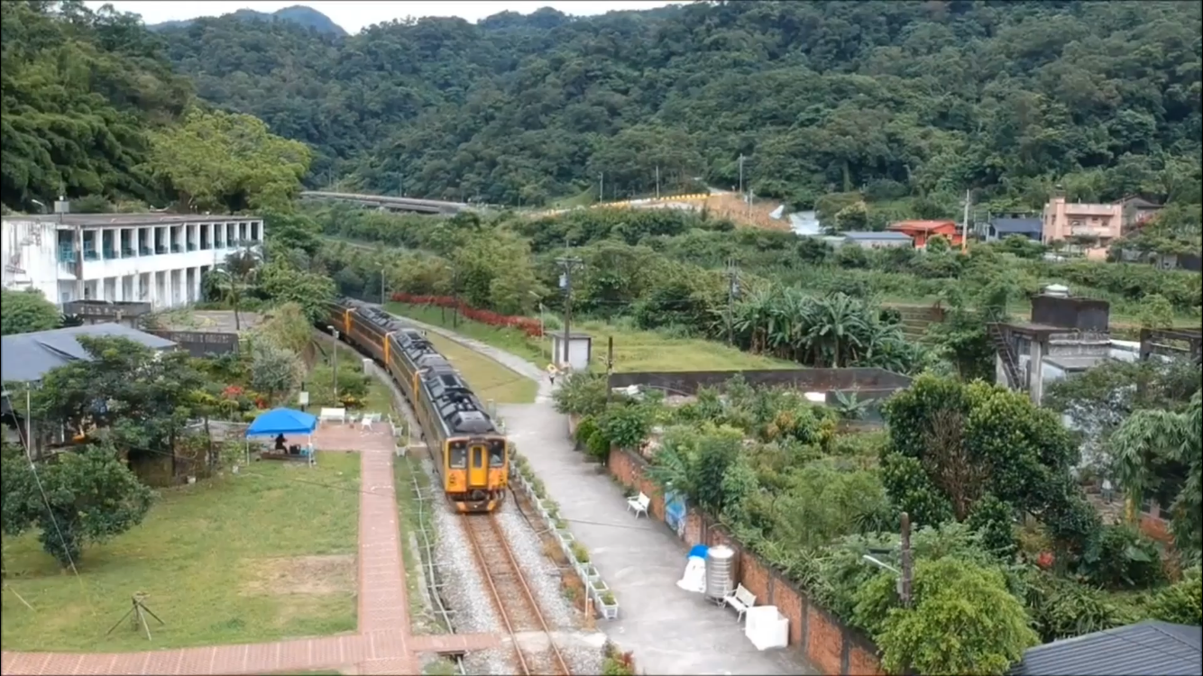
Sandiaoling is a small station along the Pingxi Railway in Ruifang District of New Taipei, near Shuoren Village that was once reliant on coal mining. Officially the first station along the Pingxi Line, it is popular with hikers for nearby trails to waterfalls. The village also has a few historical sites such as the defunct Sandiao Mine and the abandoned Shuoren Elementary School. There are also quite a few tea and coffee shops here, perfect for resting hikers to relax. Sandiaoling Station is the only train station in Taiwan that is inaccessible by car; it can only be reached by foot.
Background: The name Sandiaoling Comes from the Spanish name Santiago, which was the name the Spanish gave to the nearby Fulong Village and Santiaogo Cape when they landed there in 1626. Sandiao is the Taiwanese transliteration of Santiago. During the Qing Dynasty, Sandiaoling was also a town along the Danlan Old Trail that connected Taipei to Yilan. The Pingxi Line was completed in 1921 by the Japanese for coal transport, and opened to travelers in 1929. The reason that Sandiaoling Station is inaccessible by road is that originally it was only meant as a stop for railway workers who were directing trains at the fork here. Trains from Sandiaoling can either go up the Pingxi Line or travel on to Yilan. Another reason is that the Keelung River acts as a natural barrier to the nearest road. In 1968, another track was added between Houtong Station and Sandiaoling Station, so as to prevent train accidents, as Sandiaoling is a convergence of the Pingxi and Yilan lines. Coal mining at Sandialing stopped in the 1980s with the decline of the coal industry in Taiwan. In 2018, there were an average of 86 passengers per day to Sandiaoling Station. Hours: 24/7 (first train comes at about 5:30 AM, the last train leaves at about 10:30 PM, with one train coming every half hour or so) Tours of Pingxi: You can book a tour to Pingxi on TripAdvisor here, Klook here, or KKday here. There are many tour itineraries that you can enjoy in Shifen that will take you to multiple destinations and arrange transportation. Activities Around Pingxi: Don't forget that there are many activities available around Pingxi such as Rock Climbing, Hiking, kayaking, canoeing, snorkeling, SUP / paddle boarding, water biking, Diving, River Tracing / Canyoneering, ATVing, Horse Riding, Cooking Class, photo shoot, Jingtong Sky Lantern Police Station, Shifen Sky Lantern Experience, Waterfall Zipline, Waterfall Diving, and more on Tripadvisor here, Klook here, or KKday here. Hotels Near Pingxi: We recommend Fullon Hotel which has locations in Tamsui and Fulong near the beach (book on Booking.com here, Tripadvisor here, Agoda here, or Hotels.com here). We have stayed at and recommend Gold Mountain Ranch, which is a horse ranch and glamping destination in Jinshan. You can book a night at Gold Mountain Ranch on Klook here. You can also check out our full blog on the ranch here. We have also stayed at and recommend Hai Xia Your Home which is right in front of Fulong Beach (book on Booking.com here, Tripadvisor here, Agoda here, or Hotels.com here). Looking for a hotel? We recommend booking through Booking.com here, which provides the best quality selection of accommodation in Taiwan. Find out where to stay in our Taiwan hotels guide or search for the best hotel deals in Taiwan here. How to get there: By Train: Take the TRA to Ruifang Station, and then switch to the Pingxi Railway line. Get off at Sandiaoling Station, and you have arrived! Book tickets via the normal train (TRA) on Klook here. You can purchase a discount easy card to use on Pingxi Railway Line on Klook here or KKday here. You can also book a travel pass on Klook here. By Car/Scooter: Take Provincial Highway 2 east toward Pinglin, then get off the main highway once you reach Shuangxi. You then need to take highway 102 past Mudan (牡丹) and then turn left onto Houmu Public Road (侯牡公路), take it to the end and you will reach Shuoren Village near Sandiaoling Station (you then need to walk about 5 mintues to get the station). If you are looking for car rentals, you can also search Qeeq here, Klook here, or KKday here. You can also check out our car rental guide here. Looking for scooter rental in Taipei? You can search on Klook here or KKday here to search for options. You can also check out our scooter rental guide here. By Taxi: You can take short rides for about 150 NT, or hire a Taxi for a day for around 150 USD on Klook here. By Bus: You can also book tickets to travel to Shifen via inter-city bus on Klook here. You can also book a Taipei Sightseeing: Hop On, Hop Off Open Top Bus on TripAdvisor here. By Bicycle: Cycling is the best way to enjoy Taiwan's landscapes if you have the time and energy. Looking for bicycle rentals in Taiwan? You can use Taiwan's many Youbike sharing stations, or search for rentals on KKday here, and search for tours on Klook here. You can also check out our Taiwan cycling guide here. You can also book a Sunset Riverside Bike Ride and Historical Tour, 4 Hour Cycling in Taipei, Ultimate 8-Hour Cycling City Tour, or Taipei City Bike Tour with Night Market Experience on TripAdvisor here. For more information, check out our Taiwan transportation guide here. Map: Please see below: 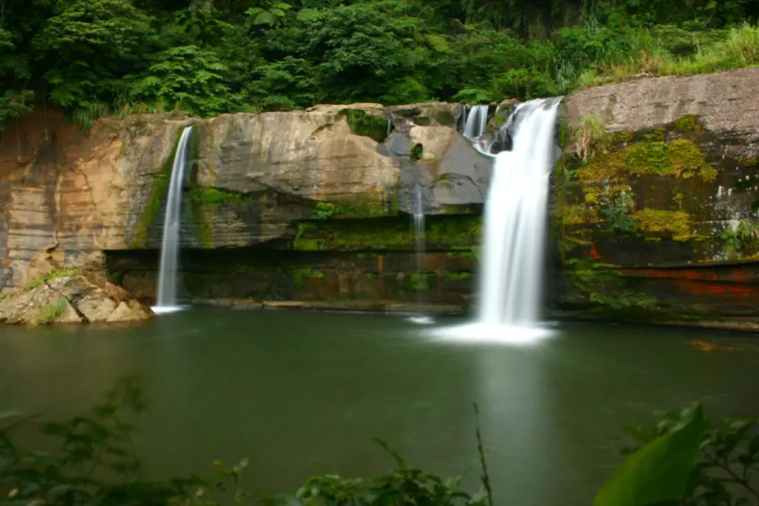
Lingjiao Waterfall (aka "Lingjiao Grotto Great Waterfall" 嶺腳石窟大瀑布) is a large waterfall and swimming hole right next to Lingjiao Station of the Pingxi Railway, on the Keelung River in Pingxi District of New Taipei. Its large cliffs are popular for jumping and has a large deep pool that is safe to swim in. Its accessibility via the Pingxi Railway has made it a popular spot, but most of the time there will not be any crowds there.
Background: Lingjiao Waterfall Is 40 meters wide and 11 meters tall, and is the second biggest waterfall in Pingxi District after Shifen Waterfall. The town of Lingjiao was named because it sits at the foot of a mountain (the name meaning literally "foot of the peak"). Lingjiao was a mining town on the Pingxi Railway, and a station there was completed during the Japanese Era in 1929. A few decades ago the waterfall was a popular spot for the locals who dug holes in the rocks at the base of the falls, so the waterfall is also known by the name "Lingjiao Grotto Great Waterfall" (嶺腳石窟大瀑布). The land around the falls was also once closed off and an admission was required, however due to mismanagement the business has long since closed down, so seeing the falls is now free. Price: Free Hours: 24/7 Tours of Pingxi: You can book a tour to Shifen on TripAdvisor here, Klook here, or KKday here. There are many tour itineraries that you can enjoy in Shifen that will take you to multiple destinations and arrange transportation. Activities Around Pingxi: Don't forget that there are many activities available around Pingxi such as Rock Climbing, Hiking, kayaking, canoeing, snorkeling, SUP / paddle boarding, water biking, Diving, River Tracing / Canyoneering, ATVing, Horse Riding, Cooking Class, photo shoot, Jingtong Sky Lantern Police Station, Shifen Sky Lantern Experience, Waterfall Zipline, Waterfall Diving, and more on Tripadvisor here, Klook here, or KKday here. Hotels Near Pingxi: We recommend Fullon Hotel which has locations in Tamsui and Fulong near the beach (book on Booking.com here, Tripadvisor here, Agoda here, or Hotels.com here). We have stayed at and recommend Gold Mountain Ranch, which is a horse ranch and glamping destination in Jinshan. You can book a night at Gold Mountain Ranch on Klook here. You can also check out our full blog on the ranch here. We have also stayed at and recommend Hai Xia Your Home which is right in front of Fulong Beach (book on Booking.com here, Tripadvisor here, Agoda here, or Hotels.com here). Looking for a hotel? We recommend booking through Booking.com here, which provides the best quality selection of accommodation in Taiwan. Find out where to stay in our Taiwan hotels guide or search for the best hotel deals in Taiwan here. How to get there: By Train: Take the TRA to Ruifang Station, and then switch to the Pingxi Railway line. Get off at Lingjiao Station, and then walk east down the road next to the train tracks, you will see the steps down to the waterfall on the right. Book tickets via the normal train (TRA) on Klook here. You can purchase a discount easy card to use on Pingxi Railway Line on Klook here or KKday here. You can also book a travel pass on Klook here. By Car/Scooter: Take provincial highway 2 east toward Pinglin, then get off the main highway once you reach Shifen. Then turn right and go west on county road 106 until you reach the Lingjiao Station turnoff. After that, you can park next to the train tracks and walk east down the road next to the train tracks, you will see the steps down to the waterfall on the right. If you are looking for car rentals, you can also search Qeeq here, Klook here, or KKday here. You can also check out our car rental guide here. Looking for scooter rental in Taipei? You can search on Klook here or KKday here to search for options. You can also check out our scooter rental guide here. By Taxi: You can take short rides for about 150 NT, or hire a Taxi for a day for around 150 USD on Klook here. By Bus: You can also book tickets to travel to Shifen via inter-city bus on Klook here. You can also book a Taipei Sightseeing: Hop On, Hop Off Open Top Bus on TripAdvisor here. By Bicycle: Cycling is the best way to enjoy Taiwan's landscapes if you have the time and energy. Looking for bicycle rentals in Taiwan? You can use Taiwan's many Youbike sharing stations, or search for rentals on KKday here, and search for tours on Klook here. You can also check out our Taiwan cycling guide here. You can also book a Sunset Riverside Bike Ride and Historical Tour, 4 Hour Cycling in Taipei, Ultimate 8-Hour Cycling City Tour, or Taipei City Bike Tour with Night Market Experience on TripAdvisor here. For more information, check out our Taiwan transportation guide here. Map: Please see below: 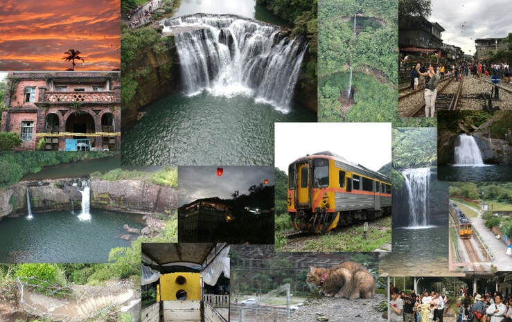
Pingxi District of New Taipei has some of the most popular attractions in Northern Taiwan. With a total of 7 stations along the Pingxi Railway Line (plus 2 if you count Ruifang and Houtong), there are endless places to explore, eat, hike, and enjoy Taiwan's history, culture, and natural beauty all in one place.
Background: Before the Pingxi Railway was built, during the Qing Dynasty a section of the Danlan Old Trail ran through roughly the same area, connecting Yilan to Tamsui. The Japanese completed the Pingxi Railway in 1921 in order to transport coal from the area. Most all of the stations and villages along the line were economically reliant on the coal industry until its downfall in the late 1990s. The coal industry remained strong after the ROC took over Taiwan after WWII, but slowly waned in the 1980s and 1990s due to the decrease in global coal prices. In the year 2000, Sanxia’s Lifeng Mine shut down operations, and Taiwan’s mining company closed, and thus all coal mining in Taiwan effectively stopped. The Pingxi Railway is a single track that is 12.9 KM long with 7 stations. Recently the government has offered many plans to connect the Pingxi Railway to the Taipei MRT via Jingtong to Jingmei, however due to many factors these plans have never been approved. The area around Pingxi and Ruifang is made up of sedimentary rock which easily erodes, creating many large waterfalls such as Shifen Falls, and pointy jagged peaks like the Pingxi Crags. Popular activities along the Pingxi Railway include hiking, river tracing, eating at one of the many old streets, setting off sky lanterns, and exploring the many historical coal mining sites. Hours: The first train reaches Sandiaoling daily at 5:25 AM and the last train leaves Jingtong at 8:33 PM. Price: 80 NT per person for a one day pass. Book tickets via the normal train (TRA) on Klook here. You can purchase a discount easy card to use on Pingxi Railway Line on Klook here or KKday here. You can also book a travel pass on Klook here. When to go: Any time of year is great. However, waterfalls are most enjoyable during the hot summer, and you may want to come for the Lantern Festival when hundreds of sky lanterns are set off at once. To avoid crowds and packed trains, do not go on weekends or holidays. Tours of Pingxi: There are many tour itineraries that you can enjoy in Shifen that will take you to multiple destinations and arrange transportation. For more information, you can check out Tripadvisor here, KKday here or Klook here, which are both great tour websites that can connect you with the right tour and tour guide for you. Here are some of the most popular tours of Pingxi:
Activities Around Pingxi: Don't forget that there are many activities available around Pingxi such as Rock Climbing, Hiking, kayaking, canoeing, snorkeling, SUP / paddle boarding, water biking, Diving, River Tracing / Canyoneering, ATVing, Horse Riding, Cooking Class, photo shoot, Jingtong Sky Lantern Police Station, Shifen Sky Lantern Experience, Waterfall Zipline, Waterfall Diving, and more on Tripadvisor here, Klook here, or KKday here. Hotels on Taiwan's Northern Coast: We recommend Fullon Hotel which has locations in Tamsui and Fulong near the beach (book on Booking.com here, Tripadvisor here, Agoda here, or Hotels.com here). We have stayed at and recommend Gold Mountain Ranch, which is a horse ranch and glamping destination in Jinshan. You can book a night at Gold Mountain Ranch on Klook here. You can also check out our full blog on the ranch here. We have also stayed at and recommend Hai Xia Your Home which is right in front of Fulong Beach (book on Booking.com here, Tripadvisor here, Agoda here, or Hotels.com here). Looking for a hotel? We recommend booking through Booking.com here, which provides the best quality selection of accommodation in Taiwan. Find out where to stay in our Taiwan hotels guide or search for the best hotel deals in Taiwan here. How to get there: By Train: Take the TRA to Ruifang Station, buy the Pingxi Railway line one day pass, and then switch to the Pingxi Railway line. Get off at any station! Book tickets via the normal train (TRA) on Klook here. You can purchase a discount easy card to use on Pingxi Railway Line on Klook here or KKday here. You can also book a travel pass on Klook here. By Car/Scooter: Take Provincial Highway 2 east toward Pinglin, then get off the main highway once you reach Shifen. You can drive right or left to reach all of the stations on the Pingxi Railway line. But please know there is limited car parking around the stations. If you are looking for car rentals, you can also search Qeeq here, Klook here, or KKday here. You can also check out our car rental guide here. Looking for scooter rental in Taipei? You can search on Klook here or KKday here to search for options. You can also check out our scooter rental guide here. By Taxi: You can take short rides for about 150 NT, or hire a Taxi for a day for around 150 USD on Klook here. By Bus: You can also book tickets to travel to Shifen via inter-city bus on Klook here. You can also book a Taipei Sightseeing: Hop On, Hop Off Open Top Bus on TripAdvisor here. By Bicycle: Cycling is the best way to enjoy Taiwan's landscapes if you have the time and energy. Looking for bicycle rentals in Taiwan? You can use Taiwan's many Youbike sharing stations, or search for rentals on KKday here, and search for tours on Klook here. You can also check out our Taiwan cycling guide here. You can also book a Sunset Riverside Bike Ride and Historical Tour, 4 Hour Cycling in Taipei, Ultimate 8-Hour Cycling City Tour, or Taipei City Bike Tour with Night Market Experience on TripAdvisor here. For more information, check out our Taiwan transportation guide here. Map: Please see below: |
Author 作家I am an American expat who has extensive experience living, working, and traveling in Taiwan. In my day, I had to learn many things about Taiwan the hard way. But I have come to learn that Taiwan is one of the best places in the world for Foreigners to live. This blog does not represent the opinions of every foreigner in Taiwan. I am just trying to help others learn more about this beautiful country. Tutor ABC - World's No. 1 Online Platform for learning English and Chinese. Get 10% off all Tutor ABC website listed prices with promo code: FOREIGNERS10 Tutor ABC - 世界第一英語和中文線上學習平台 使用促銷代碼: FOREIGNERS10 可享有 Tutor ABC 網站上列出的所有價格 10% 的折扣 Archives 檔案
April 2024
Tutor ABC - World's No. 1 Online Platform for learning English and Chinese. Get 10% off all Tutor ABC website listed prices with promo code: FOREIGNERS10 Tutor ABC - 世界第一英語和中文線上學習平台 使用促銷代碼: FOREIGNERS10 可享有 Tutor ABC 網站上列出的所有價格 10% 的折扣 Categories
|
 RSS Feed
